More like 'Looking east from north side of 5118 Douglas Road - The Roberts House'
Narrow Results By
Decade
- 2020s 132
- 2010s 84
- 2000s 1021
- 1990s 568
- 1980s 500
- 1970s
- 1960s 379
- 1950s
- 1940s 565
- 1930s 482
- 1920s 508
- 1910s 488
- 1900s 211
- 1890s 35
- 1880s 52
- 1870s 6
- 1860s 3
- 1850s 1
- 1840s 1
- 1830s 2
- 1820s 1
- 1810s 1
- 1800s 1
- 1790s 1
- 1780s 1
- 1770s 1
- 1760s 1
- 1750s 1
- 1740s 1
- 1730s 1
- 1720s 1
- 1710s 1
- 1700s 1
- 1690s 1
- 1680s 1
- 1670s 1
- 1660s 1
- 1650s 1
- 1640s 1
- 1630s 1
- 1620s 1
- 1610s 1
- 1600s 1

Helen 'The Swinging Girl' Neon Sign
https://search.heritageburnaby.ca/link/landmark591
- Repository
- Burnaby Heritage Planning
- Description
- Commercial building.
- Associated Dates
- 1956
- Formal Recognition
- Heritage Designation, Community Heritage Register
- Other Names
- Helen's Childrens Wear Sign
- Street View URL
- Google Maps Street View
- Repository
- Burnaby Heritage Planning
- Other Names
- Helen's Childrens Wear Sign
- Geographic Access
- Hastings Street
- Associated Dates
- 1956
- Formal Recognition
- Heritage Designation, Community Heritage Register
- Enactment Type
- Bylaw No. 12771
- Enactment Date
- 19/04/2010
- Description
- Commercial building.
- Heritage Value
- While the building here is of some importance as the former North Burnaby municipal office, its primary importance is its delightful neon sign that has become a North Burnaby landmark. Helen Arnold opened Helen’s Childrens Wear shop in the building next door to the old Municipal offices in 1948. In 1955, when North Burnaby moved out, she moved into the vacated building. As part of the renovations, Helen enlisted the assistance of her good friend Jimmy Wallace, owner of Vancouver’s Wallace Neon Company, to create a new sign for her expanded business. One of the company’s designers, Reeve Lehman, created the swinging neon girl that was installed in 1956. Designed in two parts, one section of the sign is cloud shaped and reads ‘Helen’s’ while the other section is a moving representation of a little girl on a swing. The sign is nine feet six inches high and nine feet wide, and the lower section is animated with an internal motor and gears. It immediately became a landmark on Hastings Street, and recently the sign’s design fame has spread far and wide as one of the best surviving examples of kinetic neon art in North America.
- Locality
- Vancouver Heights
- Historic Neighbourhood
- Vancouver Heights (Historic Neighbourhood)
- Planning Study Area
- Willingdon Heights Area
- Community
- Burnaby
- Names
- Helen's Childrens Wear
- Street Address
- 4142 Hastings Street
- Street View URL
- Google Maps Street View
Images


![Looking east from 3107 Dominion Street, [between 1952 and 1955] thumbnail](/media/hpo/_Data/_Archives_Images/_Unrestricted/600/620-020.jpg?width=280)
Looking east from 3107 Dominion Street
https://search.heritageburnaby.ca/link/archivedescription91839
- Repository
- City of Burnaby Archives
- Date
- [between 1952 and 1955]
- Collection/Fonds
- Small family fonds
- Description Level
- Item
- Physical Description
- 1 photograph : sepia copy print ; 12 cm x 16 cm
- Scope and Content
- Photograph of Adeline, Sharon, and Donna McLean in front of the property at 3093 Douglas Road. The house on the right was built by John W. Roberts in 1940 and purchased and lived in by the Hardy family. The small white building was likely used for raising chickens. The photograph was taken from 31…
- Repository
- City of Burnaby Archives
- Date
- [between 1952 and 1955]
- Collection/Fonds
- Small family fonds
- Physical Description
- 1 photograph : sepia copy print ; 12 cm x 16 cm
- Description Level
- Item
- Record No.
- 620-020
- Access Restriction
- No restrictions
- Reproduction Restriction
- No reproduction permitted
- Accession Number
- 2017-01
- Scope and Content
- Photograph of Adeline, Sharon, and Donna McLean in front of the property at 3093 Douglas Road. The house on the right was built by John W. Roberts in 1940 and purchased and lived in by the Hardy family. The small white building was likely used for raising chickens. The photograph was taken from 3107 Dominion Street, looking east.
- Media Type
- Photograph
- Notes
- Transcribed title
- Title transcribed from donor's notes
- Note in blue ink on recto of photograph reads: Mar 1952
- Note in blue ink on verso of photograph reads: "Copy - (original not available) / Courtesy of [name]"
- Note in blue ink on verso of photograph reads: "P.20"
- Note in blue ink on verso of photograph reads: "Adeline McLean, Sharon McLean / Donna Mclean / March ? 1952 / May?
- 3107 Dominion Street later renumbered 5493 Dominion Street and then subdivided into two lots: 5491 and 5495 Dominion Street.
- Street Address
- 3093 Douglas Road
- Historic Neighbourhood
- Burnaby Lake (Historic Neighbourhood)
- Planning Study Area
- Ardingley-Sprott Area
Images
![Looking east from 3107 Dominion Street, [between 1952 and 1955] thumbnail](/media/hpo/_Data/_Archives_Images/_Unrestricted/600/620-020.jpg)
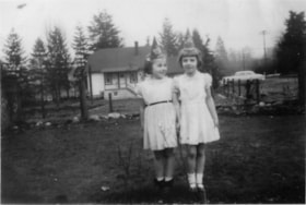
Looking east from 5493 Dominion Street
https://search.heritageburnaby.ca/link/archivedescription91840
- Repository
- City of Burnaby Archives
- Date
- February 18, 1955
- Collection/Fonds
- Small family fonds
- Description Level
- Item
- Physical Description
- 1 photograph : b&w copy print ; 12 cm x 17 cm
- Scope and Content
- Photograph of Sharon McLean and Kathryn Small standing in front the Hardys' house at 3093 Douglas Road. Both girls wear white dresses and party hats. The photograph was taken from 5493 (previously 3107) Dominion Street, looking east.
- Repository
- City of Burnaby Archives
- Date
- February 18, 1955
- Collection/Fonds
- Small family fonds
- Physical Description
- 1 photograph : b&w copy print ; 12 cm x 17 cm
- Description Level
- Item
- Record No.
- 620-021
- Access Restriction
- No restrictions
- Reproduction Restriction
- No reproduction permitted
- Accession Number
- 2017-01
- Scope and Content
- Photograph of Sharon McLean and Kathryn Small standing in front the Hardys' house at 3093 Douglas Road. Both girls wear white dresses and party hats. The photograph was taken from 5493 (previously 3107) Dominion Street, looking east.
- Media Type
- Photograph
- Notes
- Title based on contents of photograph
- Note in black ink on verso of photograph reads: "Sharon McLean Kahryn Small / Feb. 18/55"
- Note in blue ink on verso of photograph reads: "P.21"
- Note in blue ink on verso of photograph reads: "Courtesy of [name]"
- 3107 Dominion Street later renumbered 5493 Dominion Street and then subdivided into two lots: 5491 and 5495 Dominion Street.
- Street Address
- 3093 Douglas Road
- Historic Neighbourhood
- Burnaby Lake (Historic Neighbourhood)
- Planning Study Area
- Ardingley-Sprott Area
Images


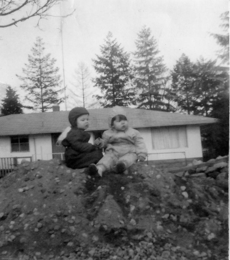
Looking east from 5493 Dominion Street
https://search.heritageburnaby.ca/link/archivedescription91841
- Repository
- City of Burnaby Archives
- Date
- 1959
- Collection/Fonds
- Small family fonds
- Description Level
- Item
- Physical Description
- 1 photograph : b&w copy print ; 11.5 cm x 10 cm
- Scope and Content
- Photograph of the Brocklebank children Brian and Pam, sitting on a dirt pile in front their single-storey house. The Hardys sold the north half of their property at 3071 Douglas Road to the Brocklebanks who built the house in 1957. The photograph was taken from 5493 (previously 3107) Dominion Str…
- Repository
- City of Burnaby Archives
- Date
- 1959
- Collection/Fonds
- Small family fonds
- Physical Description
- 1 photograph : b&w copy print ; 11.5 cm x 10 cm
- Description Level
- Item
- Record No.
- 620-022
- Access Restriction
- No restrictions
- Reproduction Restriction
- No reproduction permitted
- Accession Number
- 2017-01
- Scope and Content
- Photograph of the Brocklebank children Brian and Pam, sitting on a dirt pile in front their single-storey house. The Hardys sold the north half of their property at 3071 Douglas Road to the Brocklebanks who built the house in 1957. The photograph was taken from 5493 (previously 3107) Dominion Street, looking east.
- Media Type
- Photograph
- Notes
- Transcribed title
- Title transcribed from donor's notes
- Note in blue ink on verso of photograph reads: "P.22"
- Note in blue ink on verso of photograph reads: "Courtesy of [name]"
- Street Address
- 3071 Douglas Road
- Historic Neighbourhood
- Burnaby Lake (Historic Neighbourhood)
- Planning Study Area
- Ardingley-Sprott Area
Images

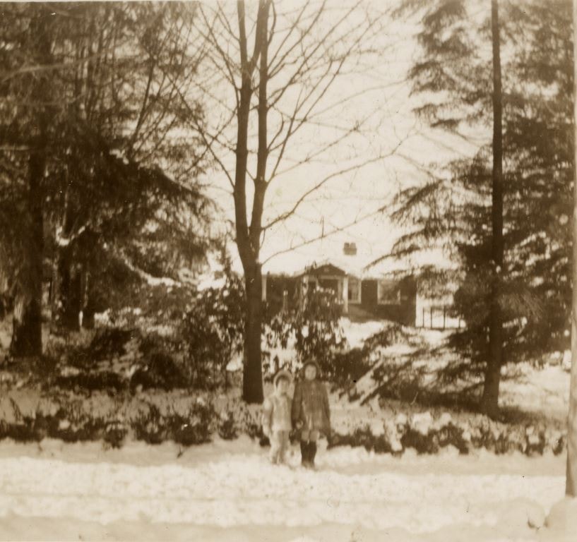
Looking west from Douglas Road
https://search.heritageburnaby.ca/link/archivedescription91831
- Repository
- City of Burnaby Archives
- Date
- 1951
- Collection/Fonds
- Small family fonds
- Description Level
- Item
- Physical Description
- 1 photograph : b&w ; 12.5 cm x 9 cm
- Scope and Content
- Photograph of Kathryn and Elizabeth Small standing in front of the Roberts' house at 5118 Douglas Road. Snow covers the ground, trees, and house and the girls wear winter coats. The photograph was taken from Douglas Road, looking west.
- Repository
- City of Burnaby Archives
- Date
- 1951
- Collection/Fonds
- Small family fonds
- Physical Description
- 1 photograph : b&w ; 12.5 cm x 9 cm
- Description Level
- Item
- Record No.
- 620-012
- Access Restriction
- No restrictions
- Reproduction Restriction
- No reproduction permitted
- Accession Number
- 2017-01
- Scope and Content
- Photograph of Kathryn and Elizabeth Small standing in front of the Roberts' house at 5118 Douglas Road. Snow covers the ground, trees, and house and the girls wear winter coats. The photograph was taken from Douglas Road, looking west.
- Media Type
- Photograph
- Notes
- Transcribed title
- Title transcribed from donor's notes
- Note in black ink on verso of photograph reads: "Kathryn and Elizabeth / Jan [struck through] 1951"
- Note in blue ink on verso of photograph reads: "March?"
- Note in blue ink on verso of photograph reads: "P.12"
- Stamp in black ink on verso of photograph reads: "754"
- 5118 Douglas Road renumbered to 3131 Douglas Road in 1958 and to 5538 Dominion Street in 1970 or 1971
- Street Address
- 3131 Douglas Road
- 5118 Douglas Road
- 5538 Dominion Street
- Historic Neighbourhood
- Burnaby Lake (Historic Neighbourhood)
- Planning Study Area
- Ardingley-Sprott Area
Images
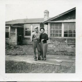
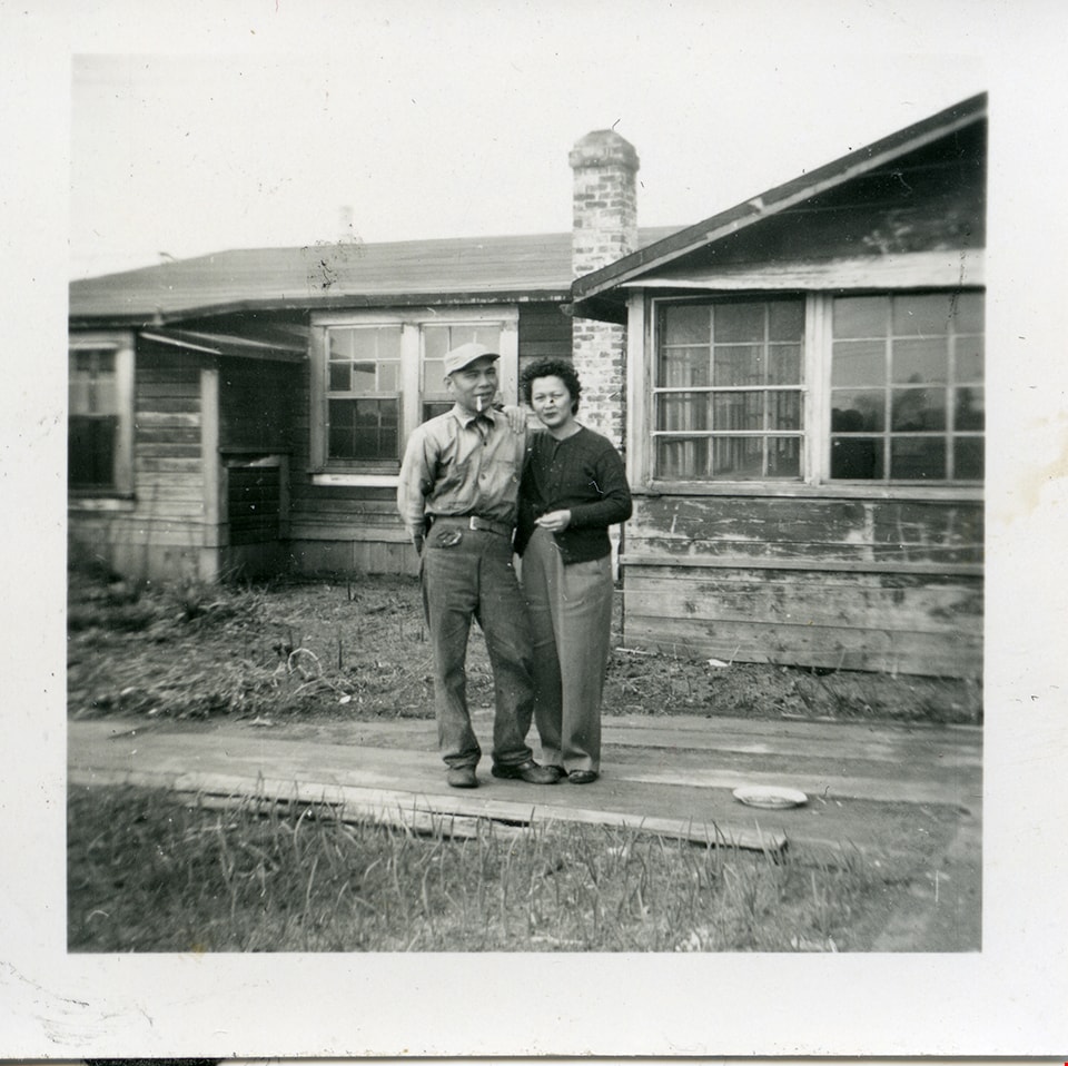
Puey Yuen Chan and Suey Ying "Laura" Yung
https://search.heritageburnaby.ca/link/museumdescription14784
- Repository
- Burnaby Village Museum
- Date
- [195-]
- Collection/Fonds
- Julie Lee and Cecil Lee family fonds
- Description Level
- Item
- Physical Description
- 1 photograph (tiff) : b&w ; 600 dpi
- Scope and Content
- Photograph of Puy Yuen Chan and Suey Ying "Laura" Jung standing on a board walk outside of an unidentified house.
- Repository
- Burnaby Village Museum
- Collection/Fonds
- Julie Lee and Cecil Lee family fonds
- Description Level
- Item
- Physical Description
- 1 photograph (tiff) : b&w ; 600 dpi
- Scope and Content
- Photograph of Puy Yuen Chan and Suey Ying "Laura" Jung standing on a board walk outside of an unidentified house.
- Accession Code
- BV020.38.7
- Access Restriction
- No restrictions
- Reproduction Restriction
- No known restrictions
- Date
- [195-]
- Media Type
- Photograph
- Scan Resolution
- 600
- Scan Date
- 26-Nov-2019
- Scale
- 100
- Notes
- Title based on contents of photograph
Images
![Paneloc marketing report, [between 1957 and 1960] thumbnail](/media/hpo/_Data/_BVM_Images/2019/2019_0040_0003_001.jpg?width=280)
Paneloc marketing report
https://search.heritageburnaby.ca/link/museumdescription15067
- Repository
- Burnaby Village Museum
- Date
- [between 1957 and 1960]
- Collection/Fonds
- Elmer Wilson Martin fonds
- Description Level
- Item
- Physical Description
- 1 report : 5 photographs + 6 architectural drawings : blueline prints ; 55 x 85 cm + 1 architectural drawing : blueline print ; 46 x 55 cm
- Scope and Content
- Item consists of a report created by Paneloc Marketing Ltd. 4217 Hastings Street Burnaby B.C. Architectural drawings within the report are drawn by Jack Pearl and designed by Elmer W. Martin, P. Engineer. Architectural drawings included in the report are titled; Paneloc Homes - All Models (2 drawin…
- Repository
- Burnaby Village Museum
- Collection/Fonds
- Elmer Wilson Martin fonds
- Description Level
- Item
- Physical Description
- 1 report : 5 photographs + 6 architectural drawings : blueline prints ; 55 x 85 cm + 1 architectural drawing : blueline print ; 46 x 55 cm
- Material Details
- Scales differ between 1"=60" and 3/4"=1'-0"
- Scope and Content
- Item consists of a report created by Paneloc Marketing Ltd. 4217 Hastings Street Burnaby B.C. Architectural drawings within the report are drawn by Jack Pearl and designed by Elmer W. Martin, P. Engineer. Architectural drawings included in the report are titled; Paneloc Homes - All Models (2 drawings); Paneloc Homes - Model 6 - 28 Panel (3 drawings) ; Paneloc Homes - Model 6-24 Panel (1 drawing) ; Paneloc Homes - Model 4 -20 Panel (1 drawing). The report includes five photographs of paneloc homes including two of completed homes and three of a paneloc building in various stages of assembly.
- Responsibility
- Panel Marketing Limited
- Accession Code
- BV019.40.3
- Access Restriction
- No restrictions
- Reproduction Restriction
- May be restricted by third party rights
- Date
- [between 1957 and 1960]
- Media Type
- Photograph
- Architectural Drawing
- Scan Resolution
- 600
- Scan Date
- February 5, 2021
- Scale
- 100
- Notes
- Title based on contents of report
- Architectural drawings were unfolded and removed from duotang binding
- According to an advertisement dated June 14, 1957 for Paneloc Manufacturing in the Vancouver Province newspaper, a paneloc display model was available for viewing at 6635 East Hastings Street in Burnaby. Some of the photographs within this report may have been at this location.
- Architectural drawings have reproduction and access restrictions. Contact Burnaby Village Museum to view.
Images
![Paneloc marketing report, [between 1957 and 1960] thumbnail](/media/hpo/_Data/_BVM_Images/2019/2019_0040_0003_001.jpg)


![Yuen Sun Toy with grandaughters, [197-] thumbnail](/media/hpo/_Data/_BVM_Images/2023/2023_0025_0012_001.jpg?width=280)
Yuen Sun Toy with grandaughters
https://search.heritageburnaby.ca/link/museumdescription20351
- Repository
- Burnaby Village Museum
- Date
- [197-]
- Collection/Fonds
- Harry Toy fonds
- Description Level
- Item
- Physical Description
- 1 photograph : col. ; 9 x 12.5 cm
- Scope and Content
- Photograph of Yuen Sun Toy standing together with her grandaughters, Melinda, Beverley and Christina Toy outside of the Canada Way Food Market located at 4694 Canada Way, Burnaby. Sign for International Meat Market is visible in the background.
- Repository
- Burnaby Village Museum
- Collection/Fonds
- Harry Toy fonds
- Series
- Harry Toy photographs series
- Description Level
- Item
- Physical Description
- 1 photograph : col. ; 9 x 12.5 cm
- Scope and Content
- Photograph of Yuen Sun Toy standing together with her grandaughters, Melinda, Beverley and Christina Toy outside of the Canada Way Food Market located at 4694 Canada Way, Burnaby. Sign for International Meat Market is visible in the background.
- Geographic Access
- Canada Way
- Street Address
- 4694 Canada Way
- Accession Code
- BV023.25.12
- Access Restriction
- No restrictions
- Reproduction Restriction
- No known restrictions
- Date
- [197-]
- Media Type
- Photograph
- Related Material
- See also BV023.16.19 - Interview with Harry Toy, Beverley Babey and Christina Toy
- For associated artifacts from Canada Way Food Market see Accession BV023.17
- Scan Resolution
- 600
- Scan Date
- 2023-12-01
- Notes
- Title based on contents of photograph
Images
![Yuen Sun Toy with grandaughters, [197-] thumbnail](/media/hpo/_Data/_BVM_Images/2023/2023_0025_0012_001.jpg)
![Blythe Eagles outside his home, [between 1955 and 1960] (date of original), copied 1996 thumbnail](/media/Hpo/_Data/_Archives_Images/_Unrestricted/205/245-002.jpg?width=280)
Blythe Eagles outside his home
https://search.heritageburnaby.ca/link/archivedescription51540
- Repository
- City of Burnaby Archives
- Date
- [between 1955 and 1960] (date of original), copied 1996
- Collection/Fonds
- Burnaby Historical Society fonds
- Description Level
- Item
- Physical Description
- 1 photograph : b&w copy negative ; 4 x 5.5 cm
- Scope and Content
- Photograph of Blythe Eagles standing in front of the Eagles' estate at Deer Lake.
- Repository
- City of Burnaby Archives
- Date
- [between 1955 and 1960] (date of original), copied 1996
- Collection/Fonds
- Burnaby Historical Society fonds
- Subseries
- Eagles family subseries
- Physical Description
- 1 photograph : b&w copy negative ; 4 x 5.5 cm
- Description Level
- Item
- Record No.
- 245-002
- Access Restriction
- No restrictions
- Reproduction Restriction
- Reproduce for fair dealing purposes only
- Accession Number
- BHS1990-11
- Scope and Content
- Photograph of Blythe Eagles standing in front of the Eagles' estate at Deer Lake.
- Names
- Eagles, Dr. Blythe
- Media Type
- Photograph
- Notes
- Title based on contents of photograph
- 1 b&w ; 12.7 x 17.7 cm print accompanying
- Geographic Access
- Sperling Avenue
- Street Address
- 5655 Sperling Avenue
- Historic Neighbourhood
- Burnaby Lake (Historic Neighbourhood)
- Planning Study Area
- Morley-Buckingham Area
Images
![Blythe Eagles outside his home, [between 1955 and 1960] (date of original), copied 1996 thumbnail](/media/Hpo/_Data/_Archives_Images/_Unrestricted/205/245-002.jpg)
![Ceperley House, [195-] thumbnail](/media/Hpo/_Data/_Archives_Images/_Unrestricted/316/329-001.jpg?width=280)
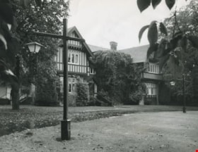
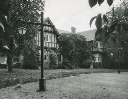
Ceperley House
https://search.heritageburnaby.ca/link/archivedescription37175
- Repository
- City of Burnaby Archives
- Date
- [195-]
- Collection/Fonds
- Burnaby Historical Society fonds
- Description Level
- Item
- Physical Description
- 1 photograph : b&w ; 7.5 x 9.5 cm
- Scope and Content
- Photograph of the Ceperley House.
- Repository
- City of Burnaby Archives
- Date
- [195-]
- Collection/Fonds
- Burnaby Historical Society fonds
- Subseries
- Photographs subseries
- Physical Description
- 1 photograph : b&w ; 7.5 x 9.5 cm
- Description Level
- Item
- Record No.
- 329-001
- Access Restriction
- No restrictions
- Reproduction Restriction
- Reproduce for fair dealing purposes only
- Accession Number
- BHS2007-04
- Scope and Content
- Photograph of the Ceperley House.
- Media Type
- Photograph
- Notes
- Title based on contents of photograph
- Photograph is a proof print
- Geographic Access
- Deer Lake Avenue
- Street Address
- 6344 Deer Lake Avenue
- Historic Neighbourhood
- Burnaby Lake (Historic Neighbourhood)
- Planning Study Area
- Douglas-Gilpin Area
Images
![Ceperley House, [195-] thumbnail](/media/Hpo/_Data/_Archives_Images/_Unrestricted/316/329-001.jpg)

Extension of McPherson Park School
https://search.heritageburnaby.ca/link/archivedescription36489
- Repository
- City of Burnaby Archives
- Date
- September 1959
- Collection/Fonds
- Burnaby Historical Society fonds
- Description Level
- Item
- Physical Description
- 1 photograph : b&w ; 8.5 x 12.5 cm print
- Scope and Content
- Photograph of the A.J. Keel house with excavation for the extension of the McPherson Park School.
- Repository
- City of Burnaby Archives
- Date
- September 1959
- Collection/Fonds
- Burnaby Historical Society fonds
- Subseries
- Keel family subseries
- Physical Description
- 1 photograph : b&w ; 8.5 x 12.5 cm print
- Description Level
- Item
- Record No.
- 279-002
- Access Restriction
- No restrictions
- Reproduction Restriction
- Reproduce for fair dealing purposes only
- Accession Number
- BHS1992-09
- Scope and Content
- Photograph of the A.J. Keel house with excavation for the extension of the McPherson Park School.
- Names
- McPherson Park School
- Media Type
- Photograph
- Notes
- Title based on contents of photograph
- Geographic Access
- Rumble Street
- Historic Neighbourhood
- Alta-Vista (Historic Neighbourhood)
- Planning Study Area
- Clinton-Glenwood Area
Images


Extension of McPherson Park School
https://search.heritageburnaby.ca/link/archivedescription36490
- Repository
- City of Burnaby Archives
- Date
- September 1959
- Collection/Fonds
- Burnaby Historical Society fonds
- Description Level
- Item
- Physical Description
- 1 photograph : b&w ; 8.5 x 12.5 cm print
- Scope and Content
- Photograph of the A.J. Keel house with a close-up of the excavation for the extension of McPherson Park School.
- Repository
- City of Burnaby Archives
- Date
- September 1959
- Collection/Fonds
- Burnaby Historical Society fonds
- Subseries
- Keel family subseries
- Physical Description
- 1 photograph : b&w ; 8.5 x 12.5 cm print
- Description Level
- Item
- Record No.
- 279-003
- Access Restriction
- No restrictions
- Reproduction Restriction
- Reproduce for fair dealing purposes only
- Accession Number
- BHS1992-09
- Scope and Content
- Photograph of the A.J. Keel house with a close-up of the excavation for the extension of McPherson Park School.
- Names
- McPherson Park School
- Media Type
- Photograph
- Notes
- Title based on contents of photograph
- Geographic Access
- Rumble Street
- Historic Neighbourhood
- Alta-Vista (Historic Neighbourhood)
- Planning Study Area
- Clinton-Glenwood Area
Images


Exterior of Love farmhouse
https://search.heritageburnaby.ca/link/museumdescription1129
- Repository
- Burnaby Village Museum
- Date
- 1971 (date of original), copied 1990
- Collection/Fonds
- Love family fonds
- Description Level
- Item
- Physical Description
- 1 photograph : col. ; 10 x 15 cm print
- Scope and Content
- Photograph of the northern exterior of the Love farmhouse while Elsie (nee Love) Hughes, her husband John and son Brent lived in the house. The one storey section housed the kitchen which was added in 1903 to the original house which was built in 1893. The house is located at 7651 Cumberland Stree…
- Repository
- Burnaby Village Museum
- Collection/Fonds
- Love family fonds
- Description Level
- Item
- Physical Description
- 1 photograph : col. ; 10 x 15 cm print
- Material Details
- Copy print was made from re-photographing an original colour slide
- Scope and Content
- Photograph of the northern exterior of the Love farmhouse while Elsie (nee Love) Hughes, her husband John and son Brent lived in the house. The one storey section housed the kitchen which was added in 1903 to the original house which was built in 1893. The house is located at 7651 Cumberland Street (Address pre 1960: 1390 Cumberland Road) and was moved from its original site to the Burnaby Village Museum in 1988 and designated a Municipal Heritage Landmark in 1992.
- Geographic Access
- Cumberland Street
- Street Address
- 7651 Cumberland Street
- Accession Code
- BV992.15.10
- Access Restriction
- Restricted access
- Reproduction Restriction
- May be restricted by third party rights
- Date
- 1971 (date of original), copied 1990
- Media Type
- Photograph
- Historic Neighbourhood
- East Burnaby (Historic Neighbourhood)
- Planning Study Area
- Cariboo-Armstrong Area
- Scan Resolution
- 600
- Scan Date
- 01-Jun-09
- Scale
- 100
- Photographer
- Parker, Albert "Bert"
- Notes
- Title based on contents of photograph
Images


Exterior of Love farmhouse
https://search.heritageburnaby.ca/link/museumdescription1130
- Repository
- Burnaby Village Museum
- Date
- 1971 (date of original), copied 1990
- Collection/Fonds
- Love family fonds
- Description Level
- Item
- Physical Description
- 1 photograph : col. ; 10 x 15 cm print
- Scope and Content
- Photograph of the exterior of the west side of the Love farnhouse while Elsie (nee Love) Hughes, her husband John and son Brent lived in the house.The one storey section housed the kitchen which was attached to the main house in 1903. The house was located at 7651 Cumberland Street (Address pre 196…
- Repository
- Burnaby Village Museum
- Collection/Fonds
- Love family fonds
- Description Level
- Item
- Physical Description
- 1 photograph : col. ; 10 x 15 cm print
- Material Details
- Copy print was made from re-photographing an original colour slide
- Scope and Content
- Photograph of the exterior of the west side of the Love farnhouse while Elsie (nee Love) Hughes, her husband John and son Brent lived in the house.The one storey section housed the kitchen which was attached to the main house in 1903. The house was located at 7651 Cumberland Street (Address pre 1960: 1390 Cumberland Road) and was moved from its original site to the Burnaby Village Museum in 1988 and designated a Municipal Heritage Landmark in 1992.
- Geographic Access
- Cumberland Street
- Street Address
- 7651 Cumberland Street
- Accession Code
- BV992.15.11
- Access Restriction
- Restricted access
- Reproduction Restriction
- May be restricted by third party rights
- Date
- 1971 (date of original), copied 1990
- Media Type
- Photograph
- Historic Neighbourhood
- East Burnaby (Historic Neighbourhood)
- Planning Study Area
- Cariboo-Armstrong Area
- Scan Resolution
- 600
- Scan Date
- 01-Jun-09
- Scale
- 100
- Photographer
- Parker, Albert "Bert"
- Notes
- Title based on contents of photograph
Images


Exterior of Love farmhouse
https://search.heritageburnaby.ca/link/museumdescription1131
- Repository
- Burnaby Village Museum
- Date
- 1971 (date of original), copied 1990
- Collection/Fonds
- Love family fonds
- Description Level
- Item
- Physical Description
- 1 photograph : col. ; 10 x 15 cm print
- Scope and Content
- Photograph of the exterior of the Love farmhouse taken from the corner of Fourteenth Avenue and Cumberland Street while Elsie (nee Love) Hughes, her husband John and son Brent lived in the house. The house was located at 7651 Cumberland Street (Address pre 1960: 1390 Cumberland Road) and was moved …
- Repository
- Burnaby Village Museum
- Collection/Fonds
- Love family fonds
- Description Level
- Item
- Physical Description
- 1 photograph : col. ; 10 x 15 cm print
- Material Details
- Copy print was made from re-photographing an original colour slide
- Scope and Content
- Photograph of the exterior of the Love farmhouse taken from the corner of Fourteenth Avenue and Cumberland Street while Elsie (nee Love) Hughes, her husband John and son Brent lived in the house. The house was located at 7651 Cumberland Street (Address pre 1960: 1390 Cumberland Road) and was moved from its original site to the Burnaby Village Museum in 1988 and designated a Municipal Heritage Landmark in 1992.
- Geographic Access
- Cumberland Street
- 14th Avenue
- Street Address
- 7651 Cumberland Street
- Accession Code
- BV992.15.12
- Access Restriction
- Restricted access
- Reproduction Restriction
- May be restricted by third party rights
- Date
- 1971 (date of original), copied 1990
- Media Type
- Photograph
- Historic Neighbourhood
- East Burnaby (Historic Neighbourhood)
- Planning Study Area
- Cariboo-Armstrong Area
- Scan Resolution
- 600
- Scan Date
- 01-Jun-09
- Scale
- 100
- Photographer
- Parker, Albert "Bert"
- Notes
- Title based on contents of photograph
Images


Front hallway entrance of Love farmhouse
https://search.heritageburnaby.ca/link/museumdescription1122
- Repository
- Burnaby Village Museum
- Date
- 1971 (date of original), copied 1990
- Collection/Fonds
- Love family fonds
- Description Level
- Item
- Physical Description
- 1 photograph : col. ; 15 x 10 cm print
- Scope and Content
- Photograph of the front hallway and entrance door of the Love farmhouse while Elsie (nee Love) Hughes, her husband John and son Brent lived in the house. The house was located at 7651 Cumberland Street (Address pre 1960: 1390 Cumberland Road) and was moved from its original site to the Burnaby Vill…
- Repository
- Burnaby Village Museum
- Collection/Fonds
- Love family fonds
- Description Level
- Item
- Physical Description
- 1 photograph : col. ; 15 x 10 cm print
- Material Details
- Copy print was made from re-photographing an original colour slide
- Scope and Content
- Photograph of the front hallway and entrance door of the Love farmhouse while Elsie (nee Love) Hughes, her husband John and son Brent lived in the house. The house was located at 7651 Cumberland Street (Address pre 1960: 1390 Cumberland Road) and was moved from its original site to the Burnaby Village Museum in 1988 and designated a Municipal Heritage Landmark in 1992.
- Geographic Access
- Cumberland Street
- Street Address
- 7651 Cumberland Street
- Accession Code
- BV992.15.3
- Access Restriction
- Restricted access
- Reproduction Restriction
- May be restricted by third party rights
- Date
- 1971 (date of original), copied 1990
- Media Type
- Photograph
- Historic Neighbourhood
- East Burnaby (Historic Neighbourhood)
- Planning Study Area
- Cariboo-Armstrong Area
- Scan Resolution
- 600
- Scan Date
- 01-Jun-09
- Scale
- 100
- Photographer
- Parker, Albert "Bert"
- Notes
- Title based on contents of photograph
Images

Hart House
https://search.heritageburnaby.ca/link/archivedescription36125
- Repository
- City of Burnaby Archives
- Date
- October 23, 1979
- Collection/Fonds
- Burnaby Historical Society fonds
- Description Level
- Item
- Physical Description
- 1 photograph : b&w ; 18.5 x 24 cm
- Scope and Content
- Photograph of the Hart House and street lights.
- Repository
- City of Burnaby Archives
- Date
- October 23, 1979
- Collection/Fonds
- Burnaby Historical Society fonds
- Subseries
- Columbian Newspaper subseries
- Physical Description
- 1 photograph : b&w ; 18.5 x 24 cm
- Description Level
- Item
- Record No.
- 222-048
- Access Restriction
- No restrictions
- Reproduction Restriction
- Reproduce for fair dealing purposes only
- Accession Number
- BHS1989-19
- Scope and Content
- Photograph of the Hart House and street lights.
- Media Type
- Photograph
- Photographer
- King, Basil
- Notes
- Title based on contents of photograph
- Newspaper clipping glued to verso of photograph reads: "Old-world elegance is a key feature of Deer Lake Park's latest aquisiton, the Riley House."
- Stamp on verso of photograph reads: "COLUMBIAN PHOTO BY BASIL KING"
- Geographic Access
- Deer Lake Avenue
- Street Address
- 6664 Deer Lake Avenue
- Historic Neighbourhood
- Burnaby Lake (Historic Neighbourhood)
- Planning Study Area
- Morley-Buckingham Area
Images
![Hart House and property, [between 1940 and 1959] thumbnail](/media/hpo/_Data/_Archives_Images/_Unrestricted/251/309-001.jpg?width=280)
Hart House and property
https://search.heritageburnaby.ca/link/archivedescription36611
- Repository
- City of Burnaby Archives
- Date
- [between 1940 and 1959]
- Collection/Fonds
- Burnaby Historical Society fonds
- Description Level
- Item
- Physical Description
- 1 photograph : sepia ; 6 x 10.5 cm
- Scope and Content
- Photograph of the Hart House and surrounding property.
- Repository
- City of Burnaby Archives
- Date
- [between 1940 and 1959]
- Collection/Fonds
- Burnaby Historical Society fonds
- Subseries
- Anne Macey subseries
- Physical Description
- 1 photograph : sepia ; 6 x 10.5 cm
- Description Level
- Item
- Record No.
- 309-001
- Access Restriction
- No restrictions
- Reproduction Restriction
- Reproduce for fair dealing purposes only
- Accession Number
- BHS1994-01
- Scope and Content
- Photograph of the Hart House and surrounding property.
- Media Type
- Photograph
- Notes
- Title based on contents of photograph
- Geographic Access
- Deer Lake Avenue
- Street Address
- 6664 Deer Lake Avenue
- Historic Neighbourhood
- Burnaby Lake (Historic Neighbourhood)
- Planning Study Area
- Morley-Buckingham Area
Images
![Hart House and property, [between 1940 and 1959] thumbnail](/media/hpo/_Data/_Archives_Images/_Unrestricted/251/309-001.jpg)
![Hart House and property, [between 1940 and 1959] thumbnail](/media/hpo/_Data/_Archives_Images/_Unrestricted/251/309-002.jpg?width=280)
Hart House and property
https://search.heritageburnaby.ca/link/archivedescription36612
- Repository
- City of Burnaby Archives
- Date
- [between 1940 and 1959]
- Collection/Fonds
- Burnaby Historical Society fonds
- Description Level
- Item
- Physical Description
- 1 photograph : sepia ; 6 x 10.5 cm
- Scope and Content
- Photograph of the side of the Hart House and its surrounding property.
- Repository
- City of Burnaby Archives
- Date
- [between 1940 and 1959]
- Collection/Fonds
- Burnaby Historical Society fonds
- Subseries
- Anne Macey subseries
- Physical Description
- 1 photograph : sepia ; 6 x 10.5 cm
- Description Level
- Item
- Record No.
- 309-002
- Access Restriction
- No restrictions
- Reproduction Restriction
- Reproduce for fair dealing purposes only
- Accession Number
- BHS1994-01
- Scope and Content
- Photograph of the side of the Hart House and its surrounding property.
- Media Type
- Photograph
- Notes
- Title based on contents of photograph
- Geographic Access
- Deer Lake Avenue
- Street Address
- 6664 Deer Lake Avenue
- Historic Neighbourhood
- Burnaby Lake (Historic Neighbourhood)
- Planning Study Area
- Morley-Buckingham Area
Images
![Hart House and property, [between 1940 and 1959] thumbnail](/media/hpo/_Data/_Archives_Images/_Unrestricted/251/309-002.jpg)
![Hart House and property, [between 1940 and 1959] thumbnail](/media/hpo/_Data/_Archives_Images/_Unrestricted/251/309-003.jpg?width=280)
Hart House and property
https://search.heritageburnaby.ca/link/archivedescription36613
- Repository
- City of Burnaby Archives
- Date
- [between 1940 and 1959]
- Collection/Fonds
- Burnaby Historical Society fonds
- Description Level
- Item
- Physical Description
- 1 photograph : sepia ; 6 x 10.5 cm
- Scope and Content
- Photograph of the side of the Hart House and its surrounding property.
- Repository
- City of Burnaby Archives
- Date
- [between 1940 and 1959]
- Collection/Fonds
- Burnaby Historical Society fonds
- Subseries
- Anne Macey subseries
- Physical Description
- 1 photograph : sepia ; 6 x 10.5 cm
- Description Level
- Item
- Record No.
- 309-003
- Access Restriction
- No restrictions
- Reproduction Restriction
- Reproduce for fair dealing purposes only
- Accession Number
- BHS1994-01
- Scope and Content
- Photograph of the side of the Hart House and its surrounding property.
- Media Type
- Photograph
- Notes
- Title based on contents of photograph
- Geographic Access
- Deer Lake Avenue
- Street Address
- 6664 Deer Lake Avenue
- Historic Neighbourhood
- Burnaby Lake (Historic Neighbourhood)
- Planning Study Area
- Morley-Buckingham Area
Images
![Hart House and property, [between 1940 and 1959] thumbnail](/media/hpo/_Data/_Archives_Images/_Unrestricted/251/309-003.jpg)