Narrow Results By
Aerial photograph of Burnaby Lake Area
https://search.heritageburnaby.ca/link/archivedescription84908
- Repository
- City of Burnaby Archives
- Date
- 1963
- Collection/Fonds
- Allan Amundsen collection
- Description Level
- Item
- Physical Description
- 1 photograph : b&w ; 22.5 x 22.5 cm
- Scope and Content
- Aerial photograph of Burnaby with Lougheed Highway in the north west corner, the Trans Canada Highway in the south east corner and Burnaby Lake appearing from the west.
- Repository
- City of Burnaby Archives
- Date
- 1963
- Collection/Fonds
- Allan Amundsen collection
- Physical Description
- 1 photograph : b&w ; 22.5 x 22.5 cm
- Description Level
- Item
- Record No.
- 561-026
- Access Restriction
- In Archives only
- Reproduction Restriction
- No reproduction permitted
- Accession Number
- 2014-08
- Scope and Content
- Aerial photograph of Burnaby with Lougheed Highway in the north west corner, the Trans Canada Highway in the south east corner and Burnaby Lake appearing from the west.
- Subjects
- Aerial Photographs
- Media Type
- Photograph
- Photographer
- Province of British Columbia
- Notes
- Title based on contents of photograph
- This photo is indentified as BC5062:25 and connects with B.C. air photograph BC5062:26 to the west and B.C. air photograph BC5062:24 to the east
- Historic Neighbourhood
- Burnaby Lake (Historic Neighbourhood)
- Lozells (Historic Neighbourhood)
- Planning Study Area
- Douglas-Gilpin Area
- Sperling-Broadway Area
- Government Road Area
- Burnaby Lake Area
Aerial photograph of Burnaby Lake Area
https://search.heritageburnaby.ca/link/archivedescription84909
- Repository
- City of Burnaby Archives
- Date
- 1963
- Collection/Fonds
- Allan Amundsen collection
- Description Level
- Item
- Physical Description
- 1 photograph : b&w ; 22.5 x 22.5 cm
- Scope and Content
- Aerial photograph of Burnaby with Lougheed Highway to the north and Burnaby Lake to the south.
- Repository
- City of Burnaby Archives
- Date
- 1963
- Collection/Fonds
- Allan Amundsen collection
- Physical Description
- 1 photograph : b&w ; 22.5 x 22.5 cm
- Description Level
- Item
- Record No.
- 561-027
- Access Restriction
- In Archives only
- Reproduction Restriction
- No reproduction permitted
- Accession Number
- 2014-08
- Scope and Content
- Aerial photograph of Burnaby with Lougheed Highway to the north and Burnaby Lake to the south.
- Subjects
- Aerial Photographs
- Media Type
- Photograph
- Photographer
- Province of British Columbia
- Notes
- Title based on contents of photograph
- This photo is indentified as BC5062:24 and connects with B.C. air photograph BC5062:25 to the west and B.C. air photograph BC5062:23 to the east
- Historic Neighbourhood
- Burnaby Lake (Historic Neighbourhood)
- Lozells (Historic Neighbourhood)
- Planning Study Area
- Douglas-Gilpin Area
- Sperling-Broadway Area
- Government Road Area
- Burnaby Lake Area
Aerial photograph of Burnaby Lake Area
https://search.heritageburnaby.ca/link/archivedescription84910
- Repository
- City of Burnaby Archives
- Date
- 1963
- Collection/Fonds
- Allan Amundsen collection
- Description Level
- Item
- Physical Description
- 1 photograph : b&w ; 22.5 x 22.5 cm
- Scope and Content
- Aerial photograph of Burnaby with Burnaby Lake to the south and Broadway to the north.
- Repository
- City of Burnaby Archives
- Date
- 1963
- Collection/Fonds
- Allan Amundsen collection
- Physical Description
- 1 photograph : b&w ; 22.5 x 22.5 cm
- Description Level
- Item
- Record No.
- 561-028
- Access Restriction
- In Archives only
- Reproduction Restriction
- No reproduction permitted
- Accession Number
- 2014-08
- Scope and Content
- Aerial photograph of Burnaby with Burnaby Lake to the south and Broadway to the north.
- Subjects
- Aerial Photographs
- Media Type
- Photograph
- Photographer
- Province of British Columbia
- Notes
- Title based on contents of photograph
- This photo is indentified as BC5062:23 and connects with B.C. air photograph BC5062:24 to the west and B.C. air photograph BC5062:22 to the east
- Historic Neighbourhood
- Burnaby Lake (Historic Neighbourhood)
- Lozells (Historic Neighbourhood)
- Planning Study Area
- Lake City Area
- Government Road Area
- Burnaby Lake Area
Dania Home
https://search.heritageburnaby.ca/link/archivedescription34585
- Repository
- City of Burnaby Archives
- Date
- 1958
- Collection/Fonds
- Burnaby Historical Society fonds
- Description Level
- Item
- Physical Description
- 1 photograph : b&w ; 17.8 x 22.7 cm
- Scope and Content
- Photograph of the exterior of the Dania Home at 4279 Norland Avenue and Canada Way. The accompanying description reads, "Dania - Modern Danish Rest Home / On site pioneer estate of C.F. Sprott, one of first reeves of Burnaby, Douglas Road - near Norland." The original house, at the centre of the b…
- Repository
- City of Burnaby Archives
- Date
- 1958
- Collection/Fonds
- Burnaby Historical Society fonds
- Subseries
- Photographs subseries
- Physical Description
- 1 photograph : b&w ; 17.8 x 22.7 cm
- Description Level
- Item
- Record No.
- 059-001
- Access Restriction
- No restrictions
- Reproduction Restriction
- Reproduce for fair dealing purposes only
- Accession Number
- BHS2007-04
- Scope and Content
- Photograph of the exterior of the Dania Home at 4279 Norland Avenue and Canada Way. The accompanying description reads, "Dania - Modern Danish Rest Home / On site pioneer estate of C.F. Sprott, one of first reeves of Burnaby, Douglas Road - near Norland." The original house, at the centre of the building, was one of the earliest homes in the Burnaby Lake area, built in 1891 by Charles F. Sprott with the assistance of Bernard R. Hill.
- Names
- Dania Home
- Media Type
- Photograph
- Notes
- Title based on contents of photograph
- Geographic Access
- Norland Avenue
- Street Address
- 4279 Norland Avenue
- Historic Neighbourhood
- Burnaby Lake (Historic Neighbourhood)
- Planning Study Area
- Douglas-Gilpin Area
Images
Aerial photograph of Burnaby
https://search.heritageburnaby.ca/link/archivedescription84907
- Repository
- City of Burnaby Archives
- Date
- 1963
- Collection/Fonds
- Allan Amundsen collection
- Description Level
- Item
- Physical Description
- 1 photograph : b&w ; 22.5 x 22.5 cm
- Scope and Content
- Aerial photograph of Burnaby with the Trans Canada Highway running from through and Burnaby Lake in the south east corner.
- Repository
- City of Burnaby Archives
- Date
- 1963
- Collection/Fonds
- Allan Amundsen collection
- Physical Description
- 1 photograph : b&w ; 22.5 x 22.5 cm
- Description Level
- Item
- Record No.
- 561-025
- Access Restriction
- In Archives only
- Reproduction Restriction
- No reproduction permitted
- Accession Number
- 2014-08
- Scope and Content
- Aerial photograph of Burnaby with the Trans Canada Highway running from through and Burnaby Lake in the south east corner.
- Subjects
- Aerial Photographs
- Media Type
- Photograph
- Photographer
- Province of British Columbia
- Notes
- Title based on contents of photograph
- This photo is indentified as BC5062:26 and connects with B.C. air photograph BC5062:27 to the west and B.C. air photograph BC5062:25 to the east
- Historic Neighbourhood
- Burnaby Lake (Historic Neighbourhood)
- Planning Study Area
- Douglas-Gilpin Area
- Ardingley-Sprott Area
- Burnaby Lake Area
Aerial photograph of Burnaby
https://search.heritageburnaby.ca/link/archivedescription84911
- Repository
- City of Burnaby Archives
- Date
- 1963
- Collection/Fonds
- Allan Amundsen collection
- Description Level
- Item
- Physical Description
- 1 photograph : b&w ; 22.5 x 22.5 cm
- Scope and Content
- Aerial photograph of Burnaby with Lougheed Highway running west to east through the middle of the photograph and the Trans Canada Highway in the lower left segment.
- Repository
- City of Burnaby Archives
- Date
- 1963
- Collection/Fonds
- Allan Amundsen collection
- Physical Description
- 1 photograph : b&w ; 22.5 x 22.5 cm
- Description Level
- Item
- Record No.
- 561-029
- Access Restriction
- In Archives only
- Reproduction Restriction
- No reproduction permitted
- Accession Number
- 2014-08
- Scope and Content
- Aerial photograph of Burnaby with Lougheed Highway running west to east through the middle of the photograph and the Trans Canada Highway in the lower left segment.
- Subjects
- Aerial Photographs
- Media Type
- Photograph
- Photographer
- Province of British Columbia
- Notes
- Title based on contents of photograph
- This photo is indentified as BC5062:22 and connects with B.C. air photograph BC5062:23 to the west and B.C. air photograph BC5062:21
- Historic Neighbourhood
- Lozells (Historic Neighbourhood)
- Burquitlam (Historic Neighbourhood)
- Planning Study Area
- Lake City Area
- Government Road Area
- Burnaby Lake Area
- Lyndhurst Area
- Cariboo-Armstrong Area
![Aerial view of Burnaby Lake, October 20, 1961 (date of original), copied [1985] thumbnail](/media/hpo/_Data/_BVM_Images/1985/1985_0457_0002_001.jpg?width=280)
Aerial view of Burnaby Lake
https://search.heritageburnaby.ca/link/museumdescription10583
- Repository
- Burnaby Village Museum
- Date
- October 20, 1961 (date of original), copied [1985]
- Collection/Fonds
- Burnaby Village Museum Photograph collection
- Description Level
- Item
- Physical Description
- 1 photograph : b&w copy negative ; 10 x 12 cm
- Scope and Content
- Photograph of aerial view of Burnaby Lake and construction for water main crossing at Piper Avenue.
- Repository
- Burnaby Village Museum
- Collection/Fonds
- Burnaby Village Museum Photograph collection
- Description Level
- Item
- Physical Description
- 1 photograph : b&w copy negative ; 10 x 12 cm
- Scope and Content
- Photograph of aerial view of Burnaby Lake and construction for water main crossing at Piper Avenue.
- Accession Code
- BV985.457.2
- Access Restriction
- No restrictions
- Reproduction Restriction
- May be restricted by third party rights
- Date
- October 20, 1961 (date of original), copied [1985]
- Media Type
- Photograph
- Historic Neighbourhood
- Burnaby Lake (Historic Neighbourhood)
- Planning Study Area
- Burnaby Lake Area
- Scan Resolution
- 1200
- Scan Date
- 2022-06-07
- Photographer
- George Allen Aerial Photos Limited
- Notes
- Title based on contents of photograph
Images
![Aerial view of Burnaby Lake, October 20, 1961 (date of original), copied [1985] thumbnail](/media/hpo/_Data/_BVM_Images/1985/1985_0457_0002_001.jpg)
![Boal family home, [1950] thumbnail](/media/hpo/_Data/_BVM_Images/2017/201700280022_001.jpg?width=280)
Boal family home
https://search.heritageburnaby.ca/link/museumdescription4215
- Repository
- Burnaby Village Museum
- Date
- [1950]
- Collection/Fonds
- Burnaby Village Museum Photograph collection
- Description Level
- Item
- Physical Description
- 1 photograph : b&w ; 6.5 x 9 cm
- Scope and Content
- Photograph of the Boal home at 4319 Norland Ave in Burnaby. This is a three-quarter shot of the house which has new, light coloured siding (white?) and a garage in the back. A man is mowing the lawn next to the house.
- Repository
- Burnaby Village Museum
- Collection/Fonds
- Burnaby Village Museum Photograph collection
- Description Level
- Item
- Physical Description
- 1 photograph : b&w ; 6.5 x 9 cm
- Material Details
- Handwritten text in ink on front of photograph reads: "1950".
- Stamped numeral on back of photograph reads: "452".
- Handwritten text on back of photograph reads: "summer, 1950 / Boals' house".
- Scope and Content
- Photograph of the Boal home at 4319 Norland Ave in Burnaby. This is a three-quarter shot of the house which has new, light coloured siding (white?) and a garage in the back. A man is mowing the lawn next to the house.
- History
- Material belonged to Glen and Ann Boal (nee Lockhart), who grew up in Burnaby and attended Burnaby South High School. They met and became engaged and married in 1954.
- Geographic Access
- Norland Avenue
- Street Address
- 4319 Norland Avenue
- Accession Code
- BV017.28.22
- Access Restriction
- No restrictions
- Reproduction Restriction
- No known restrictions
- Date
- [1950]
- Media Type
- Photograph
- Historic Neighbourhood
- Burnaby Lake (Historic Neighbourhood)
- Planning Study Area
- Burnaby Lake Area
- Scan Resolution
- 600
- Scan Date
- 06-Mar-2018
- Notes
- Title based on contents of photograph
Images
![Boal family home, [1950] thumbnail](/media/hpo/_Data/_BVM_Images/2017/201700280022_001.jpg)
![Boal family home, [195-] thumbnail](/media/hpo/_Data/_BVM_Images/2017/201700280023_001.jpg?width=280)
Boal family home
https://search.heritageburnaby.ca/link/museumdescription4216
- Repository
- Burnaby Village Museum
- Date
- [195-]
- Collection/Fonds
- Burnaby Village Museum Photograph collection
- Description Level
- Item
- Physical Description
- 1 photograph : col. ; 9 x 13 cm
- Scope and Content
- Photograph of the Boal home at 4319 Norland Ave in Burnaby. This is a three-quarter shot of the house. The house has been altered by enclosing the front porch and lowering the front door to ground level. Doors and window sills are painted light blue. Window shutters have been added. The house is wh…
- Repository
- Burnaby Village Museum
- Collection/Fonds
- Burnaby Village Museum Photograph collection
- Description Level
- Item
- Physical Description
- 1 photograph : col. ; 9 x 13 cm
- Scope and Content
- Photograph of the Boal home at 4319 Norland Ave in Burnaby. This is a three-quarter shot of the house. The house has been altered by enclosing the front porch and lowering the front door to ground level. Doors and window sills are painted light blue. Window shutters have been added. The house is white. There are trees in full leaf around the house.
- History
- Material belonged to Glen and Ann Boal (nee Lockhart), who grew up in Burnaby and attended Burnaby South High School. They met and became engaged and married in 1954.
- Geographic Access
- Norland Avenue
- Street Address
- 4319 Norland Avenue
- Accession Code
- BV017.28.23
- Access Restriction
- No restrictions
- Reproduction Restriction
- No known restrictions
- Date
- [195-]
- Media Type
- Photograph
- Historic Neighbourhood
- Burnaby Lake (Historic Neighbourhood)
- Planning Study Area
- Burnaby Lake Area
- Scan Resolution
- 600
- Scan Date
- 06-Mar-2018
- Notes
- Title based on contents of photograph
Images
![Boal family home, [195-] thumbnail](/media/hpo/_Data/_BVM_Images/2017/201700280023_001.jpg)
Burnaby Lake Tram #1228
https://search.heritageburnaby.ca/link/archivedescription35991
- Repository
- City of Burnaby Archives
- Date
- June 1951
- Collection/Fonds
- Burnaby Historical Society fonds
- Description Level
- Item
- Physical Description
- 1 photograph : col. ; 10 x 15 cm print
- Scope and Content
- Photograph of Tram #1228 on the Burnaby Lake Interurban line, near Stormont station.
- Repository
- City of Burnaby Archives
- Date
- June 1951
- Collection/Fonds
- Burnaby Historical Society fonds
- Subseries
- Geoff Meugans subseries
- Physical Description
- 1 photograph : col. ; 10 x 15 cm print
- Description Level
- Item
- Record No.
- 208-002
- Access Restriction
- No restrictions
- Reproduction Restriction
- Reproduce for fair dealing purposes only
- Accession Number
- BHS1988-08
- Scope and Content
- Photograph of Tram #1228 on the Burnaby Lake Interurban line, near Stormont station.
- Subjects
- Transportation - Electric Railroads
- Media Type
- Photograph
- Notes
- Title based on contents of photograph
- Geographic Access
- Burnaby Lake Interurban line
- Planning Study Area
- Burnaby Lake Area
Images

Burnaby Lake Tram #1230
https://search.heritageburnaby.ca/link/archivedescription35996
- Repository
- City of Burnaby Archives
- Date
- August 1951
- Collection/Fonds
- Burnaby Historical Society fonds
- Description Level
- Item
- Physical Description
- 1 photograph : col. ; 10 x 15 cm print
- Scope and Content
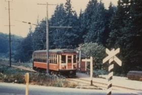
- Photograph of Tram #1230 on the Burnaby Lake Interurban line, at Cariboo station's level crossing.
- Repository
- City of Burnaby Archives
- Date
- August 1951
- Collection/Fonds
- Burnaby Historical Society fonds
- Subseries
- Geoff Meugans subseries
- Physical Description
- 1 photograph : col. ; 10 x 15 cm print
- Description Level
- Item
- Record No.
- 208-007
- Access Restriction
- No restrictions
- Reproduction Restriction
- Reproduce for fair dealing purposes only
- Accession Number
- BHS1988-08
- Scope and Content
- Photograph of Tram #1230 on the Burnaby Lake Interurban line, at Cariboo station's level crossing.
- Media Type
- Photograph
- Notes
- Title based on contents of photograph
- Geographic Access
- Burnaby Lake Interurban line
- Planning Study Area
- Burnaby Lake Area
Images

Burnaby Lake Tram #1231
https://search.heritageburnaby.ca/link/archivedescription35994
- Repository
- City of Burnaby Archives
- Date
- August 1951
- Collection/Fonds
- Burnaby Historical Society fonds
- Description Level
- Item
- Physical Description
- 1 photograph : col. ; 10 x 15 cm print
- Scope and Content
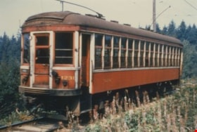
- Photograph of Tram #1231 on the Burnaby Lake Interurban line, near Stormont station.
- Repository
- City of Burnaby Archives
- Date
- August 1951
- Collection/Fonds
- Burnaby Historical Society fonds
- Subseries
- Geoff Meugans subseries
- Physical Description
- 1 photograph : col. ; 10 x 15 cm print
- Description Level
- Item
- Record No.
- 208-005
- Access Restriction
- No restrictions
- Reproduction Restriction
- Reproduce for fair dealing purposes only
- Accession Number
- BHS1988-08
- Scope and Content
- Photograph of Tram #1231 on the Burnaby Lake Interurban line, near Stormont station.
- Subjects
- Transportation - Electric Railroads
- Media Type
- Photograph
- Notes
- Title based on contents of photograph
- Geographic Access
- Burnaby Lake Interurban line
- Planning Study Area
- Burnaby Lake Area
Images

Burnaby Lake Tram #1233
https://search.heritageburnaby.ca/link/archivedescription35992
- Repository
- City of Burnaby Archives
- Date
- June 1951
- Collection/Fonds
- Burnaby Historical Society fonds
- Description Level
- Item
- Physical Description
- 1 photograph : col. ; 10 x 15 cm print
- Scope and Content
- Photograph of the caboose of Tram #1233, on the Burnaby Lake Interurban line, near Cariboo station.
- Repository
- City of Burnaby Archives
- Date
- June 1951
- Collection/Fonds
- Burnaby Historical Society fonds
- Subseries
- Geoff Meugans subseries
- Physical Description
- 1 photograph : col. ; 10 x 15 cm print
- Description Level
- Item
- Record No.
- 208-003
- Access Restriction
- No restrictions
- Reproduction Restriction
- Reproduce for fair dealing purposes only
- Accession Number
- BHS1988-08
- Scope and Content
- Photograph of the caboose of Tram #1233, on the Burnaby Lake Interurban line, near Cariboo station.
- Subjects
- Transportation - Electric Railroads
- Media Type
- Photograph
- Notes
- Title based on contents of photograph
- Geographic Access
- Burnaby Lake Interurban line
- Planning Study Area
- Burnaby Lake Area
Images


Burnaby Lake Tram #1234
https://search.heritageburnaby.ca/link/archivedescription35990
- Repository
- City of Burnaby Archives
- Date
- May 1951
- Collection/Fonds
- Burnaby Historical Society fonds
- Description Level
- Item
- Physical Description
- 1 photograph : col. ; 10 x 15 cm print
- Scope and Content
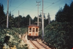
- Photograph of Tram #1234 on the Burnaby Lake Interurban line, near Stormont station.
- Repository
- City of Burnaby Archives
- Date
- May 1951
- Collection/Fonds
- Burnaby Historical Society fonds
- Subseries
- Geoff Meugans subseries
- Physical Description
- 1 photograph : col. ; 10 x 15 cm print
- Description Level
- Item
- Record No.
- 208-001
- Access Restriction
- No restrictions
- Reproduction Restriction
- Reproduce for fair dealing purposes only
- Accession Number
- BHS1988-08
- Scope and Content
- Photograph of Tram #1234 on the Burnaby Lake Interurban line, near Stormont station.
- Subjects
- Transportation - Electric Railroads
- Media Type
- Photograph
- Notes
- Title based on contents of photograph
- Geographic Access
- Burnaby Lake Interurban line
- Planning Study Area
- Burnaby Lake Area
Images
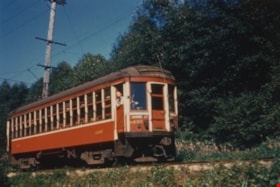
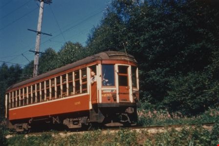
Burnaby Lake Tram #1235
https://search.heritageburnaby.ca/link/archivedescription35993
- Repository
- City of Burnaby Archives
- Date
- July 1951
- Collection/Fonds
- Burnaby Historical Society fonds
- Description Level
- Item
- Physical Description
- 1 photograph : col. ; 10 x 15 cm print
- Scope and Content
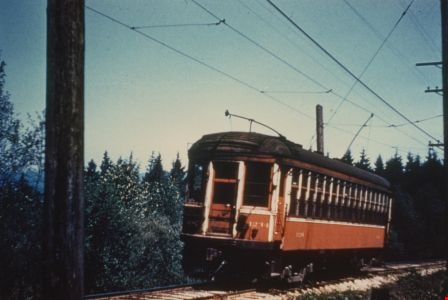
- Photograph of Tram #1235 on the Burnaby Lake Interurban line, near Cumberland Road station. The tram conductor can be seen poking his head out of the side door as he drives.
- Repository
- City of Burnaby Archives
- Date
- July 1951
- Collection/Fonds
- Burnaby Historical Society fonds
- Subseries
- Geoff Meugans subseries
- Physical Description
- 1 photograph : col. ; 10 x 15 cm print
- Description Level
- Item
- Record No.
- 208-004
- Access Restriction
- No restrictions
- Reproduction Restriction
- Reproduce for fair dealing purposes only
- Accession Number
- BHS1988-08
- Scope and Content
- Photograph of Tram #1235 on the Burnaby Lake Interurban line, near Cumberland Road station. The tram conductor can be seen poking his head out of the side door as he drives.
- Subjects
- Transportation - Electric Railroads
- Media Type
- Photograph
- Notes
- Title based on contents of photograph
- Geographic Access
- Burnaby Lake Interurban line
- Planning Study Area
- Burnaby Lake Area
Images
![Channel after dredging operation, 1951 (date of original), copied [1985] thumbnail](/media/hpo/_Data/_BVM_Images/1985/1985_0457_0007_001.jpg?width=280)
Channel after dredging operation
https://search.heritageburnaby.ca/link/museumdescription10588
- Repository
- Burnaby Village Museum
- Date
- 1951 (date of original), copied [1985]
- Collection/Fonds
- Burnaby Village Museum Photograph collection
- Description Level
- Item
- Physical Description
- 1 photograph : b&w copy negative ; 10 x 12.5 cm
- Scope and Content
- Photograph of channel of Burnaby Lake after dredging operation, 1951.
- Repository
- Burnaby Village Museum
- Collection/Fonds
- Burnaby Village Museum Photograph collection
- Description Level
- Item
- Physical Description
- 1 photograph : b&w copy negative ; 10 x 12.5 cm
- Scope and Content
- Photograph of channel of Burnaby Lake after dredging operation, 1951.
- Accession Code
- BV985.457.7
- Access Restriction
- No restrictions
- Reproduction Restriction
- May be restricted by third party rights
- Date
- 1951 (date of original), copied [1985]
- Media Type
- Photograph
- Historic Neighbourhood
- Burnaby Lake (Historic Neighbourhood)
- Planning Study Area
- Burnaby Lake Area
- Scan Resolution
- 1200
- Scan Date
- 2022-06-07
- Notes
- Title based on contents of photograph
Images
![Channel after dredging operation, 1951 (date of original), copied [1985] thumbnail](/media/hpo/_Data/_BVM_Images/1985/1985_0457_0007_001.jpg)
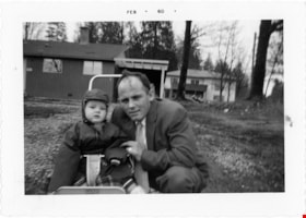
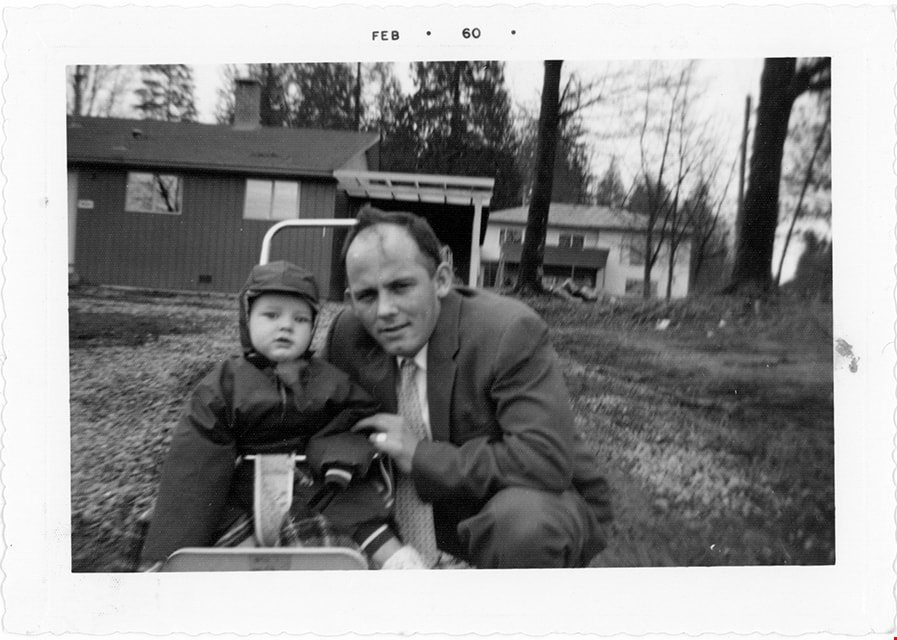
Cor and Sjouke Hiemstra in front of house
https://search.heritageburnaby.ca/link/museumdescription19128
- Repository
- Burnaby Village Museum
- Date
- Feb. 1960
- Collection/Fonds
- Cornelius and Lucy Hiemstra family fonds
- Description Level
- Item
- Physical Description
- 1 photograph : b&w ; 9.5 x 13.5 cm
- Scope and Content
- Photograph of Cornelius "Cor" Hiemstra with his eldest child Sjouke Hiemstra. Sjouke Hiemstra is in a stroller with his father crouched next to him, on the lawn in front of their house located at 5636 Canada Way.
- Repository
- Burnaby Village Museum
- Collection/Fonds
- Cornelius and Lucy Hiemstra family fonds
- Description Level
- Item
- Physical Description
- 1 photograph : b&w ; 9.5 x 13.5 cm
- Scope and Content
- Photograph of Cornelius "Cor" Hiemstra with his eldest child Sjouke Hiemstra. Sjouke Hiemstra is in a stroller with his father crouched next to him, on the lawn in front of their house located at 5636 Canada Way.
- Geographic Access
- Canada Way
- Accession Code
- BV022.15.8
- Access Restriction
- No restrictions
- Reproduction Restriction
- May be restricted by third party rights
- Date
- Feb. 1960
- Media Type
- Photograph
- Historic Neighbourhood
- Burnaby Lake (Historic Neighbourhood)
- Planning Study Area
- Burnaby Lake Area
- Notes
- Title based on contents of photograph
- Date stamp on recto of photograph reads: "FEB_60"
- Stamp in red ink on verso of photograph reads: "A "PICTURE PRINT" / MADE BY / VANCOUVER PHOTOFINISHING CO."
Images
![Dredge for clearing channel through Burnaby Lake, March 1951 (date of original), copied [1985] thumbnail](/media/hpo/_Data/_BVM_Images/1985/1985_0457_0004_001.jpg?width=280)
Dredge for clearing channel through Burnaby Lake
https://search.heritageburnaby.ca/link/museumdescription10585
- Repository
- Burnaby Village Museum
- Date
- March 1951 (date of original), copied [1985]
- Collection/Fonds
- Burnaby Village Museum Photograph collection
- Description Level
- Item
- Physical Description
- 1 photograph : b&w copy negative ; 10 x 12.5 cm
- Scope and Content
- Photograph of dredge for clearing channel through Burnaby Lake, March 1951.
- Repository
- Burnaby Village Museum
- Collection/Fonds
- Burnaby Village Museum Photograph collection
- Description Level
- Item
- Physical Description
- 1 photograph : b&w copy negative ; 10 x 12.5 cm
- Scope and Content
- Photograph of dredge for clearing channel through Burnaby Lake, March 1951.
- Accession Code
- BV985.457.4
- Access Restriction
- No restrictions
- Reproduction Restriction
- May be restricted by third party rights
- Date
- March 1951 (date of original), copied [1985]
- Media Type
- Photograph
- Historic Neighbourhood
- Burnaby Lake (Historic Neighbourhood)
- Planning Study Area
- Burnaby Lake Area
- Scan Resolution
- 1200
- Scan Date
- 2022-06-07
- Photographer
- Lindsay, Jack
- Notes
- Title based on contents of photograph
Images
![Dredge for clearing channel through Burnaby Lake, March 1951 (date of original), copied [1985] thumbnail](/media/hpo/_Data/_BVM_Images/1985/1985_0457_0004_001.jpg)
![Kincaid house, [196-] (date of original), copied 1995 thumbnail](/media/Hpo/_Data/_Archives_Images/_Unrestricted/316/324-001.jpg?width=280)
Kincaid house
https://search.heritageburnaby.ca/link/archivedescription37124
- Repository
- City of Burnaby Archives
- Date
- [196-] (date of original), copied 1995
- Collection/Fonds
- Burnaby Historical Society fonds
- Description Level
- Item
- Physical Description
- 1 photograph : b&w ; 8.5 x 12.5 cm print
- Scope and Content
- Photograph of three members of the Kincaid family standing outside of the Kincaid house on Glencarin Drive.
- Repository
- City of Burnaby Archives
- Date
- [196-] (date of original), copied 1995
- Collection/Fonds
- Burnaby Historical Society fonds
- Subseries
- Photographs subseries
- Physical Description
- 1 photograph : b&w ; 8.5 x 12.5 cm print
- Description Level
- Item
- Record No.
- 324-001
- Access Restriction
- No restrictions
- Reproduction Restriction
- Reproduce for fair dealing purposes only
- Accession Number
- BHS1995-18
- Scope and Content
- Photograph of three members of the Kincaid family standing outside of the Kincaid house on Glencarin Drive.
- Subjects
- Buildings - Residential - Houses
- Media Type
- Photograph
- Notes
- Title based on contents of photograph
- Geographic Access
- Glencarin Drive
- Historic Neighbourhood
- Burnaby Lake (Historic Neighbourhood)
- Planning Study Area
- Burnaby Lake Area
Images
![Kincaid house, [196-] (date of original), copied 1995 thumbnail](/media/Hpo/_Data/_Archives_Images/_Unrestricted/316/324-001.jpg)

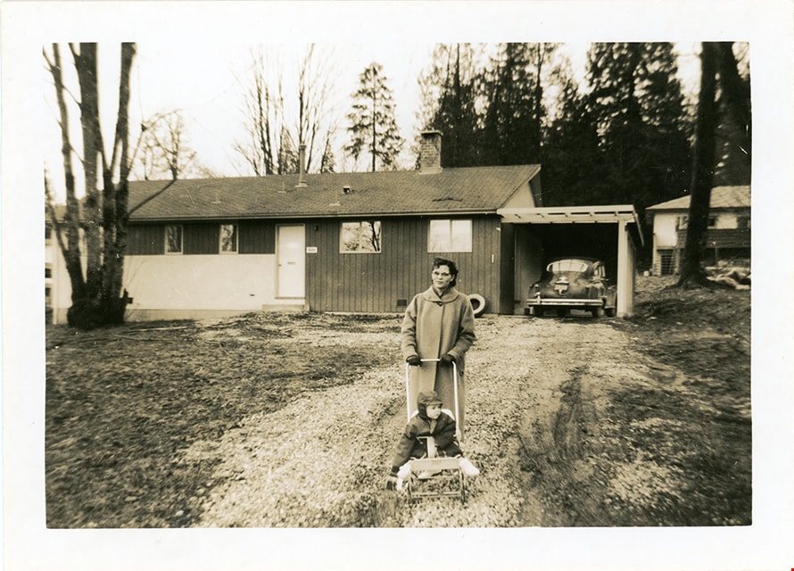
Lucy and Sjouke Hiemstra in front of house
https://search.heritageburnaby.ca/link/museumdescription19127
- Repository
- Burnaby Village Museum
- Date
- Feb. 1960
- Collection/Fonds
- Cornelius and Lucy Hiemstra family fonds
- Description Level
- Item
- Physical Description
- 1 photograph : b&w ; 8.5 x 11.5 cm
- Scope and Content
- Photograph of Lucy Hiemstra pushing her eldest child Sjouke Hiemstra in a stroller on the grass in front of their house located at 5636 Canada Way.
- Repository
- Burnaby Village Museum
- Collection/Fonds
- Cornelius and Lucy Hiemstra family fonds
- Description Level
- Item
- Physical Description
- 1 photograph : b&w ; 8.5 x 11.5 cm
- Scope and Content
- Photograph of Lucy Hiemstra pushing her eldest child Sjouke Hiemstra in a stroller on the grass in front of their house located at 5636 Canada Way.
- Geographic Access
- Canada Way
- Accession Code
- BV022.15.7
- Access Restriction
- No restrictions
- Reproduction Restriction
- May be restricted by third party rights
- Date
- Feb. 1960
- Media Type
- Photograph
- Historic Neighbourhood
- Burnaby Lake (Historic Neighbourhood)
- Planning Study Area
- Burnaby Lake Area
- Notes
- Title based on contents of photograph
- note in blue ink on verso of photograph reads: "Feb. 1960 / Sg. C. Hiemstra Jr."
- Stamp on verso of photograph reads: "919A"
Images