More like '6664 Deer Lake Avenue games room'
Narrow Results By
Subject
- Advertising Medium - Signs and Signboards 4
- Aerial Photographs 2
- Animals - Dogs 3
- Animals - Horses 1
- Armament - Firearms 2
- Buildings 4
- Buildings - Agricultural - Greenhouses 1
- Buildings - Civic - City Halls 2
- Buildings - Civic - Fire Halls 3
- Buildings - Civic - Hospitals 2
- Buildings - Civic - Libraries 2
- Buildings - Commercial 4
![Chapel at Fairacres, [between 1939 and 1954] thumbnail](/media/hpo/_Data/_Archives_Images/_Unrestricted/205/242-001.jpg?width=280)
Chapel at Fairacres
https://search.heritageburnaby.ca/link/archivedescription36251
- Repository
- City of Burnaby Archives
- Date
- [between 1939 and 1954]
- Collection/Fonds
- Burnaby Historical Society fonds
- Description Level
- Item
- Physical Description
- 1 photograph : b&w copy negative ; 3 x 4 cm
- Scope and Content
- Photograph of the chapel of the Order of St. Benedict at the Ceperley Mansion when they purchased and occupied the mansion from 1939 to 1954. They converted the drawing room into a chapel, placing the altar in front of the fireplace. A platform with a cross on a table. The letters "LOCUS ISTE SANCT…
- Repository
- City of Burnaby Archives
- Date
- [between 1939 and 1954]
- Collection/Fonds
- Burnaby Historical Society fonds
- Subseries
- Burnaby Art Gallery subseries
- Physical Description
- 1 photograph : b&w copy negative ; 3 x 4 cm
- Description Level
- Item
- Record No.
- 242-001
- Access Restriction
- No restrictions
- Reproduction Restriction
- No known restrictions
- Accession Number
- BHS1990-05
- Scope and Content
- Photograph of the chapel of the Order of St. Benedict at the Ceperley Mansion when they purchased and occupied the mansion from 1939 to 1954. They converted the drawing room into a chapel, placing the altar in front of the fireplace. A platform with a cross on a table. The letters "LOCUS ISTE SANCTUS EST" are inscribed on the wall above the cross. There is a picture of baby Jesus held by the Virgin Mary on one side of the platform, and a Saint holding a baby on the other.
- Names
- Westminster Priory
- Media Type
- Photograph
- Notes
- Title based on contents of photograph 1 b&w copy print accompanying
- Geographic Access
- Deer Lake Avenue
- Street Address
- 6344 Deer Lake Avenue
- Historic Neighbourhood
- Burnaby Lake (Historic Neighbourhood)
- Planning Study Area
- Douglas-Gilpin Area
Images
![Chapel at Fairacres, [between 1939 and 1954] thumbnail](/media/hpo/_Data/_Archives_Images/_Unrestricted/205/242-001.jpg)
![Chapel at Fairacres, [between 1939 and 1954] (date of original), copied 1979 thumbnail](/media/hpo/_Data/_BVM_Images/1979/1979_0034_0002_001.jpg?width=280)
Chapel at Fairacres
https://search.heritageburnaby.ca/link/museumdescription1629
- Repository
- Burnaby Village Museum
- Date
- [between 1939 and 1954] (date of original), copied 1979
- Collection/Fonds
- Burnaby Village Museum Photograph collection
- Description Level
- Item
- Physical Description
- 1 photograph : b&w ; 20.3 x 25.2 cm print
- Scope and Content
- Photograph of the chapel of the Order of St. Benedict at the Ceperley Mansion when they purchased and occupied the mansion from 1939 to 1954. They converted the drawing room into a chapel, placing the altar in front of the fireplace. A platform with a cross on a table. The letters "LOCUS ISTE SANCT…
- Repository
- Burnaby Village Museum
- Collection/Fonds
- Burnaby Village Museum Photograph collection
- Description Level
- Item
- Physical Description
- 1 photograph : b&w ; 20.3 x 25.2 cm print
- Scope and Content
- Photograph of the chapel of the Order of St. Benedict at the Ceperley Mansion when they purchased and occupied the mansion from 1939 to 1954. They converted the drawing room into a chapel, placing the altar in front of the fireplace. A platform with a cross on a table. The letters "LOCUS ISTE SANCTUS EST" are inscribed on the wall above the cross. There is a picture of baby Jesus held by the Virgin Mary on one side of the platform, and a Saint holding a baby on the other.
- Names
- Westminster Priory
- Geographic Access
- Deer Lake Avenue
- Street Address
- 6344 Deer Lake Avenue
- Accession Code
- HV979.34.2
- Access Restriction
- Restricted access
- Reproduction Restriction
- May be restricted by third party rights
- Date
- [between 1939 and 1954] (date of original), copied 1979
- Media Type
- Photograph
- Historic Neighbourhood
- Burnaby Lake (Historic Neighbourhood)
- Planning Study Area
- Douglas-Gilpin Area
- Scan Resolution
- 600
- Scan Date
- 2023-09-12
- Notes
- Title based on contents of photograph
Images
![Chapel at Fairacres, [between 1939 and 1954] (date of original), copied 1979 thumbnail](/media/hpo/_Data/_BVM_Images/1979/1979_0034_0002_001.jpg)
![Christ the King Seminary, 1945 (date of original), copied [2001] thumbnail](/media/hpo/_Data/_Archives_Images/_Unrestricted/371/416-002.jpg?width=280)
Christ the King Seminary
https://search.heritageburnaby.ca/link/archivedescription38355
- Repository
- City of Burnaby Archives
- Date
- 1945 (date of original), copied [2001]
- Collection/Fonds
- Burnaby Historical Society fonds
- Description Level
- Item
- Physical Description
- 1 photograph : b&w ; 20.5 x 25.5 cm print
- Scope and Content
- Photograph of the Robert and Bessie Anderson house at Deer Lake, which was built in 1912. In 1939, the house was purchased by the Benedictine Monks for use as part of the Seminary of Christ the King. In 1971, the house was purchased by Burnaby to be used as part of the Arts Centre and, in 1992, wa…
- Repository
- City of Burnaby Archives
- Date
- 1945 (date of original), copied [2001]
- Collection/Fonds
- Burnaby Historical Society fonds
- Subseries
- Municipal record subseries
- Physical Description
- 1 photograph : b&w ; 20.5 x 25.5 cm print
- Description Level
- Item
- Record No.
- 416-002
- Access Restriction
- No restrictions
- Reproduction Restriction
- No known restrictions
- Accession Number
- BHS2001-6
- Scope and Content
- Photograph of the Robert and Bessie Anderson house at Deer Lake, which was built in 1912. In 1939, the house was purchased by the Benedictine Monks for use as part of the Seminary of Christ the King. In 1971, the house was purchased by Burnaby to be used as part of the Arts Centre and, in 1992, was designated as a city heritage site.
- Names
- Christ the King Seminary
- Media Type
- Photograph
- Notes
- Title based on contents of photograph
- Geographic Access
- Deer Lake Avenue
- Historic Neighbourhood
- Burnaby Lake (Historic Neighbourhood)
- Planning Study Area
- Douglas-Gilpin Area
Images
![Christ the King Seminary, 1945 (date of original), copied [2001] thumbnail](/media/hpo/_Data/_Archives_Images/_Unrestricted/371/416-002.jpg)
Cunningham family
https://search.heritageburnaby.ca/link/archivedescription77527
- Repository
- City of Burnaby Archives
- Date
- 1944
- Collection/Fonds
- Montgomery family fonds
- Description Level
- Item
- Physical Description
- 1 photograph : b&w ; 7 x 12 cm
- Scope and Content
- Photograph of (from left) Charles "Cleve" Cunningham, his wife Ruth Cunningham holding their son Fred "Freddie" Cunningham Jr, with Freddie's grandparents Edna Cunningham and Fred Cunningham on the right. The three generations of Cunninghams are standing in front of Fred and Edna Cunningham's house…
- Repository
- City of Burnaby Archives
- Date
- 1944
- Collection/Fonds
- Montgomery family fonds
- Physical Description
- 1 photograph : b&w ; 7 x 12 cm
- Description Level
- Item
- Record No.
- 554-002
- Access Restriction
- No restrictions
- Reproduction Restriction
- No known restrictions
- Accession Number
- 2013-14
- Scope and Content
- Photograph of (from left) Charles "Cleve" Cunningham, his wife Ruth Cunningham holding their son Fred "Freddie" Cunningham Jr, with Freddie's grandparents Edna Cunningham and Fred Cunningham on the right. The three generations of Cunninghams are standing in front of Fred and Edna Cunningham's house on Douglas Road (this house was given heritage designation by the City of Burnaby in 1996).
- Names
- Cunningham, Charles "Cleve"
- Cunningham, Fred
- Cunningham, Fred Jr. "Freddy"
- Cunningham, Ruth
- Cunningham, Edna Elizabeth
- Media Type
- Photograph
- Notes
- Title based on contents of photograph
- Note in pencil on verso of photograph reads: "Cleve / Fredie [sic] / Ruth / Auntie Ed / Onkie / Burnaby / 1920? / or /30?"
- Street Address
- 3555 Douglas Road
- Historic Neighbourhood
- Burnaby Lake (Historic Neighbourhood)
- Planning Study Area
- Douglas-Gilpin Area
Images
![Hart House and property, [between 1940 and 1959] thumbnail](/media/hpo/_Data/_Archives_Images/_Unrestricted/251/309-001.jpg?width=280)
Hart House and property
https://search.heritageburnaby.ca/link/archivedescription36611
- Repository
- City of Burnaby Archives
- Date
- [between 1940 and 1959]
- Collection/Fonds
- Burnaby Historical Society fonds
- Description Level
- Item
- Physical Description
- 1 photograph : sepia ; 6 x 10.5 cm
- Scope and Content
- Photograph of the Hart House and surrounding property.
- Repository
- City of Burnaby Archives
- Date
- [between 1940 and 1959]
- Collection/Fonds
- Burnaby Historical Society fonds
- Subseries
- Anne Macey subseries
- Physical Description
- 1 photograph : sepia ; 6 x 10.5 cm
- Description Level
- Item
- Record No.
- 309-001
- Access Restriction
- No restrictions
- Reproduction Restriction
- Reproduce for fair dealing purposes only
- Accession Number
- BHS1994-01
- Scope and Content
- Photograph of the Hart House and surrounding property.
- Media Type
- Photograph
- Notes
- Title based on contents of photograph
- Geographic Access
- Deer Lake Avenue
- Street Address
- 6664 Deer Lake Avenue
- Historic Neighbourhood
- Burnaby Lake (Historic Neighbourhood)
- Planning Study Area
- Morley-Buckingham Area
Images
![Hart House and property, [between 1940 and 1959] thumbnail](/media/hpo/_Data/_Archives_Images/_Unrestricted/251/309-001.jpg)
![Hart House and property, [between 1940 and 1959] thumbnail](/media/hpo/_Data/_Archives_Images/_Unrestricted/251/309-002.jpg?width=280)
Hart House and property
https://search.heritageburnaby.ca/link/archivedescription36612
- Repository
- City of Burnaby Archives
- Date
- [between 1940 and 1959]
- Collection/Fonds
- Burnaby Historical Society fonds
- Description Level
- Item
- Physical Description
- 1 photograph : sepia ; 6 x 10.5 cm
- Scope and Content
- Photograph of the side of the Hart House and its surrounding property.
- Repository
- City of Burnaby Archives
- Date
- [between 1940 and 1959]
- Collection/Fonds
- Burnaby Historical Society fonds
- Subseries
- Anne Macey subseries
- Physical Description
- 1 photograph : sepia ; 6 x 10.5 cm
- Description Level
- Item
- Record No.
- 309-002
- Access Restriction
- No restrictions
- Reproduction Restriction
- Reproduce for fair dealing purposes only
- Accession Number
- BHS1994-01
- Scope and Content
- Photograph of the side of the Hart House and its surrounding property.
- Media Type
- Photograph
- Notes
- Title based on contents of photograph
- Geographic Access
- Deer Lake Avenue
- Street Address
- 6664 Deer Lake Avenue
- Historic Neighbourhood
- Burnaby Lake (Historic Neighbourhood)
- Planning Study Area
- Morley-Buckingham Area
Images
![Hart House and property, [between 1940 and 1959] thumbnail](/media/hpo/_Data/_Archives_Images/_Unrestricted/251/309-002.jpg)
![Hart House and property, [between 1940 and 1959] thumbnail](/media/hpo/_Data/_Archives_Images/_Unrestricted/251/309-003.jpg?width=280)
Hart House and property
https://search.heritageburnaby.ca/link/archivedescription36613
- Repository
- City of Burnaby Archives
- Date
- [between 1940 and 1959]
- Collection/Fonds
- Burnaby Historical Society fonds
- Description Level
- Item
- Physical Description
- 1 photograph : sepia ; 6 x 10.5 cm
- Scope and Content
- Photograph of the side of the Hart House and its surrounding property.
- Repository
- City of Burnaby Archives
- Date
- [between 1940 and 1959]
- Collection/Fonds
- Burnaby Historical Society fonds
- Subseries
- Anne Macey subseries
- Physical Description
- 1 photograph : sepia ; 6 x 10.5 cm
- Description Level
- Item
- Record No.
- 309-003
- Access Restriction
- No restrictions
- Reproduction Restriction
- Reproduce for fair dealing purposes only
- Accession Number
- BHS1994-01
- Scope and Content
- Photograph of the side of the Hart House and its surrounding property.
- Media Type
- Photograph
- Notes
- Title based on contents of photograph
- Geographic Access
- Deer Lake Avenue
- Street Address
- 6664 Deer Lake Avenue
- Historic Neighbourhood
- Burnaby Lake (Historic Neighbourhood)
- Planning Study Area
- Morley-Buckingham Area
Images
![Hart House and property, [between 1940 and 1959] thumbnail](/media/hpo/_Data/_Archives_Images/_Unrestricted/251/309-003.jpg)
![Albert Parker with dog, [between 1930 and 1940] (date of original), copied 1998 thumbnail](/media/hpo/_Data/_BVM_Images/2018/2018_0041_0170_001.jpg?width=280)
Albert Parker with dog
https://search.heritageburnaby.ca/link/museumdescription9985
- Repository
- Burnaby Village Museum
- Date
- [between 1930 and 1940] (date of original), copied 1998
- Collection/Fonds
- Burnaby Village Museum fonds
- Description Level
- Item
- Physical Description
- 1 photograph : sepia print ; 13 x 9.5 cm
- Scope and Content
- Photograph of young Albert Parker sitting on the ground with a dog. Behind him is the barn with a model "T" Ford parked inside. Albert is wearing a newsboy cap and is holding a black dog between his knees. In 1928 after Sarah Parker's father, Jesse Love died, William and Sarah (nee Love) Parker pu…
- Repository
- Burnaby Village Museum
- Collection/Fonds
- Burnaby Village Museum fonds
- Series
- Jesse Love farmhouse series
- Subseries
- Love family photographs subseries
- Description Level
- Item
- Physical Description
- 1 photograph : sepia print ; 13 x 9.5 cm
- Scope and Content
- Photograph of young Albert Parker sitting on the ground with a dog. Behind him is the barn with a model "T" Ford parked inside. Albert is wearing a newsboy cap and is holding a black dog between his knees. In 1928 after Sarah Parker's father, Jesse Love died, William and Sarah (nee Love) Parker purchased the Love farmhouse located at 1390 Cumberland Road. They lived there until 1961, with their three children; Albert, Bill and Elsie.
- Subjects
- Buildings - Heritage
- Geographic Access
- Cumberland Street
- Street Address
- 7651 Cumberland Street
- Accession Code
- BV018.41.170
- Access Restriction
- No restrictions
- Reproduction Restriction
- May be restricted by third party rights
- Date
- [between 1930 and 1940] (date of original), copied 1998
- Media Type
- Photograph
- Historic Neighbourhood
- East Burnaby (Historic Neighbourhood)
- Planning Study Area
- Cariboo-Armstrong Area
- Scan Resolution
- 600
- Scan Date
- 25-Feb-2019
- Scale
- 100
- Notes
- Title based on contents of photograph
Images
![Albert Parker with dog, [between 1930 and 1940] (date of original), copied 1998 thumbnail](/media/hpo/_Data/_BVM_Images/2018/2018_0041_0170_001.jpg)
![Parker family tennis court, [between 1930 and 1940] (date of original), copied 1998 thumbnail](/media/hpo/_Data/_BVM_Images/2018/2018_0041_0175_001.jpg?width=280)
Parker family tennis court
https://search.heritageburnaby.ca/link/museumdescription9984
- Repository
- Burnaby Village Museum
- Date
- [between 1930 and 1940] (date of original), copied 1998
- Collection/Fonds
- Burnaby Village Museum fonds
- Description Level
- Item
- Physical Description
- 1 photograph : b&w negative ; 35 mm
- Scope and Content
- Photograph of members of the Parker family and friends holding tennis rackets and standing on a tennis court at 1390 Cumberland Road. People are identified from L to R as; Lucy Deacon, Sid Batton, Walter Harris, Elsie Parker, Maud, Albert Parker, Bill Parker, Elsie Parker, Jo Harris and William Par…
- Repository
- Burnaby Village Museum
- Collection/Fonds
- Burnaby Village Museum fonds
- Series
- Jesse Love farmhouse series
- Subseries
- Love family photographs subseries
- Description Level
- Item
- Physical Description
- 1 photograph : b&w negative ; 35 mm
- Scope and Content
- Photograph of members of the Parker family and friends holding tennis rackets and standing on a tennis court at 1390 Cumberland Road. People are identified from L to R as; Lucy Deacon, Sid Batton, Walter Harris, Elsie Parker, Maud, Albert Parker, Bill Parker, Elsie Parker, Jo Harris and William Parker. The tennis court was built by William Parker with help from his son Albert. The court was first made of dirt, then grass with wood layed across to flatten it out. In the late 1920s William made the court out of wood. William and Sarah (nee Love) Parker purchased the Love farmhouse at 1390 Cumberland Road in 1928 after Sarah's father, Jesse Love died. William and Sarah lived there with their three children Albert, Bill and Elsie until 1961.
- Subjects
- Buildings - Heritage
- Geographic Access
- Cumberland Street
- Street Address
- 7651 Cumberland Street
- Accession Code
- BV018.41.175
- Access Restriction
- No restrictions
- Reproduction Restriction
- May be restricted by third party rights
- Date
- [between 1930 and 1940] (date of original), copied 1998
- Media Type
- Photograph
- Historic Neighbourhood
- East Burnaby (Historic Neighbourhood)
- Planning Study Area
- Cariboo-Armstrong Area
- Scan Resolution
- 2400
- Scan Date
- 4-Mar-2019
- Scale
- 100
- Notes
- Title based on contents of photograph
- 1 b&w copy print accompanying
Images
![Parker family tennis court, [between 1930 and 1940] (date of original), copied 1998 thumbnail](/media/hpo/_Data/_BVM_Images/2018/2018_0041_0175_001.jpg)
![Parkers at pond, [between 1930 and 1940] (date of original), copied 1998 thumbnail](/media/hpo/_Data/_BVM_Images/2018/2018_0041_0168_001.jpg?width=280)
Parkers at pond
https://search.heritageburnaby.ca/link/museumdescription9982
- Repository
- Burnaby Village Museum
- Date
- [between 1930 and 1940] (date of original), copied 1998
- Collection/Fonds
- Burnaby Village Museum fonds
- Description Level
- Item
- Physical Description
- 1 photograph : sepia print ; 10.5 x 18 cm
- Scope and Content
- Photograph of four women and three men sitting outside of the Love farmhouse at 1390 Cumberland Road. The group is sitting amongst large rocks and a small pond. The kitchen of the Love farmhouse and the barn are behind them. A few of the people are holding tennis rackets. In 1928 after Sarah Parke…
- Repository
- Burnaby Village Museum
- Collection/Fonds
- Burnaby Village Museum fonds
- Series
- Jesse Love farmhouse series
- Subseries
- Love family photographs subseries
- Description Level
- Item
- Physical Description
- 1 photograph : sepia print ; 10.5 x 18 cm
- Scope and Content
- Photograph of four women and three men sitting outside of the Love farmhouse at 1390 Cumberland Road. The group is sitting amongst large rocks and a small pond. The kitchen of the Love farmhouse and the barn are behind them. A few of the people are holding tennis rackets. In 1928 after Sarah Parker's father, Jesse Love died, William and Sarah (nee Love) Parker purchased the Love farmhouse located at 1390 Cumberland Road. They lived there until 1961, with their three children; Albert, Bill and Elsie.
- Subjects
- Buildings - Heritage
- Sports - Tennis
- Geographic Access
- Cumberland Street
- Street Address
- 7651 Cumberland Street
- Accession Code
- BV018.41.168
- Access Restriction
- No restrictions
- Reproduction Restriction
- May be restricted by third party rights
- Date
- [between 1930 and 1940] (date of original), copied 1998
- Media Type
- Photograph
- Historic Neighbourhood
- East Burnaby (Historic Neighbourhood)
- Planning Study Area
- Cariboo-Armstrong Area
- Scan Resolution
- 600
- Scan Date
- 25-Feb-2019
- Scale
- 100
- Notes
- Title based on contents of photograph
- Photograph was copied from the Albert Parker photograph album in 1998
Images
![Parkers at pond, [between 1930 and 1940] (date of original), copied 1998 thumbnail](/media/hpo/_Data/_BVM_Images/2018/2018_0041_0168_001.jpg)
![William Parker with shovel, [between 1930 and 1940] (date of original), copied 1998 thumbnail](/media/hpo/_Data/_BVM_Images/2018/2018_0041_0169_001.jpg?width=280)
William Parker with shovel
https://search.heritageburnaby.ca/link/museumdescription9983
- Repository
- Burnaby Village Museum
- Date
- [between 1930 and 1940] (date of original), copied 1998
- Collection/Fonds
- Burnaby Village Museum fonds
- Description Level
- Item
- Physical Description
- 1 photograph : sepia print ; 13 x 9.5 cm
- Scope and Content
- Photograph of William Parker digging with a shovel on the grounds of the Love farmhouse. There is a barn and tree behind him. In 1928 after Sarah Parker's father, Jesse Love died, William and Sarah (nee Love) Parker purchased the Love farmhouse located at 1390 Cumberland Road. They lived there unt…
- Repository
- Burnaby Village Museum
- Collection/Fonds
- Burnaby Village Museum fonds
- Series
- Jesse Love farmhouse series
- Subseries
- Love family photographs subseries
- Description Level
- Item
- Physical Description
- 1 photograph : sepia print ; 13 x 9.5 cm
- Scope and Content
- Photograph of William Parker digging with a shovel on the grounds of the Love farmhouse. There is a barn and tree behind him. In 1928 after Sarah Parker's father, Jesse Love died, William and Sarah (nee Love) Parker purchased the Love farmhouse located at 1390 Cumberland Road. They lived there until 1961, with their three children; Albert, Bill and Elsie.
- Subjects
- Buildings - Heritage
- Geographic Access
- Cumberland Street
- Street Address
- 7651 Cumberland Street
- Accession Code
- BV018.41.169
- Access Restriction
- No restrictions
- Reproduction Restriction
- May be restricted by third party rights
- Date
- [between 1930 and 1940] (date of original), copied 1998
- Media Type
- Photograph
- Historic Neighbourhood
- East Burnaby (Historic Neighbourhood)
- Planning Study Area
- Cariboo-Armstrong Area
- Scan Resolution
- 600
- Scan Date
- 25-Feb-2019
- Scale
- 100
- Notes
- Title based on contents of photograph
- Photograph was copied from the Albert Parker photograph album in 1998
Images
![William Parker with shovel, [between 1930 and 1940] (date of original), copied 1998 thumbnail](/media/hpo/_Data/_BVM_Images/2018/2018_0041_0169_001.jpg)
Construction site
https://search.heritageburnaby.ca/link/archivedescription34215
- Repository
- City of Burnaby Archives
- Date
- June 29, 1947
- Collection/Fonds
- Burnaby Historical Society fonds
- Description Level
- Item
- Physical Description
- 1 photograph : b&w negative ; 6.8 x 11.2 cm
- Scope and Content
- Photograph of five men standing outside at a construction site. Buildings, houses and lumber can be seen in the background. This is part of the Willingdon Heights subdivision site.
- Repository
- City of Burnaby Archives
- Date
- June 29, 1947
- Collection/Fonds
- Burnaby Historical Society fonds
- Subseries
- Alfred Bingham subseries
- Physical Description
- 1 photograph : b&w negative ; 6.8 x 11.2 cm
- Description Level
- Item
- Record No.
- 010-131
- Access Restriction
- No restrictions
- Reproduction Restriction
- Reproduce for fair dealing purposes only
- Accession Number
- BHS2007-04
- Scope and Content
- Photograph of five men standing outside at a construction site. Buildings, houses and lumber can be seen in the background. This is part of the Willingdon Heights subdivision site.
- Media Type
- Photograph
- Photographer
- Bingham, Alfred "Alf"
- Notes
- Title based on contents of photograph
Images
Edmonds Street and Kingsway
https://search.heritageburnaby.ca/link/archivedescription37823
- Repository
- City of Burnaby Archives
- Date
- 1944 (date of original), copied 1991
- Collection/Fonds
- Burnaby Historical Society fonds
- Description Level
- Item
- Physical Description
- 1 photograph : b&w ; 2.8 x 4.5 cm print on contact sheet 20.3 x 26.4 cm
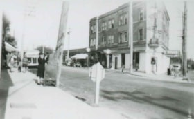
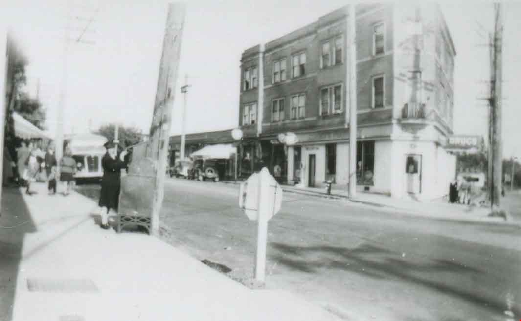
- Scope and Content
- Photograph of the intersection of Edmonds Street and Kingsway. The triangular Edmonds Block can be seen at the right and Ruth Hollands is visible putting a letter in a mailbox.
- Repository
- City of Burnaby Archives
- Date
- 1944 (date of original), copied 1991
- Collection/Fonds
- Burnaby Historical Society fonds
- Subseries
- Burnaby Image Bank subseries
- Physical Description
- 1 photograph : b&w ; 2.8 x 4.5 cm print on contact sheet 20.3 x 26.4 cm
- Description Level
- Item
- Record No.
- 370-411
- Access Restriction
- No restrictions
- Reproduction Restriction
- No known restrictions
- Accession Number
- BHS1999-03
- Scope and Content
- Photograph of the intersection of Edmonds Street and Kingsway. The triangular Edmonds Block can be seen at the right and Ruth Hollands is visible putting a letter in a mailbox.
- Names
- Hollands, Ruth
- Media Type
- Photograph
- Notes
- Title based on contents of photograph
- 2 b&w copy prints accompanying
- 1 b&w copy negative accompanying
- Negative has a pink cast
- Geographic Access
- Edmonds Street
- Kingsway
- Historic Neighbourhood
- Edmonds (Historic Neighbourhood)
Images
![Sperling Avenue near Burris Street, [1946 or 1947] (date of original), copied 1991 thumbnail](/media/hpo/_Data/_Archives_Images/_Unrestricted/370/370-529.jpg?width=280)
Sperling Avenue near Burris Street
https://search.heritageburnaby.ca/link/archivedescription37942
- Repository
- City of Burnaby Archives
- Date
- [1946 or 1947] (date of original), copied 1991
- Collection/Fonds
- Burnaby Historical Society fonds
- Description Level
- Item
- Physical Description
- 1 photograph : b&w ; 3.5 x 4.4 cm print on contact sheet 20.5 x 26.7 cm
- Scope and Content
- Photograph of Sperling Avenue near Burris Street in the snow. Burnaby United Church is the second building from the right. The photograph was taken facing northwest.
- Repository
- City of Burnaby Archives
- Date
- [1946 or 1947] (date of original), copied 1991
- Collection/Fonds
- Burnaby Historical Society fonds
- Subseries
- Burnaby Image Bank subseries
- Physical Description
- 1 photograph : b&w ; 3.5 x 4.4 cm print on contact sheet 20.5 x 26.7 cm
- Description Level
- Item
- Record No.
- 370-529
- Access Restriction
- No restrictions
- Reproduction Restriction
- No known restrictions
- Accession Number
- BHS1999-03
- Scope and Content
- Photograph of Sperling Avenue near Burris Street in the snow. Burnaby United Church is the second building from the right. The photograph was taken facing northwest.
- Names
- Burnaby United Church
- Media Type
- Photograph
- Notes
- Title based on contents of photograph
- 1 b&w copy negative accompanying
- Negative has a pink cast
- Geographic Access
- Sperling Avenue
- Burris Street
- Historic Neighbourhood
- Burnaby Lake (Historic Neighbourhood)
- Planning Study Area
- Morley-Buckingham Area
Images
![Sperling Avenue near Burris Street, [1946 or 1947] (date of original), copied 1991 thumbnail](/media/hpo/_Data/_Archives_Images/_Unrestricted/370/370-529.jpg)
Winch Street program
https://search.heritageburnaby.ca/link/museumdescription15051
- Repository
- Burnaby Village Museum
- Date
- Jan. 1949
- Collection/Fonds
- Elmer Wilson Martin fonds
- Description Level
- Item
- Physical Description
- 1 photograph : b&w ; 7 x 11.5 cm
- Scope and Content
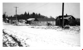
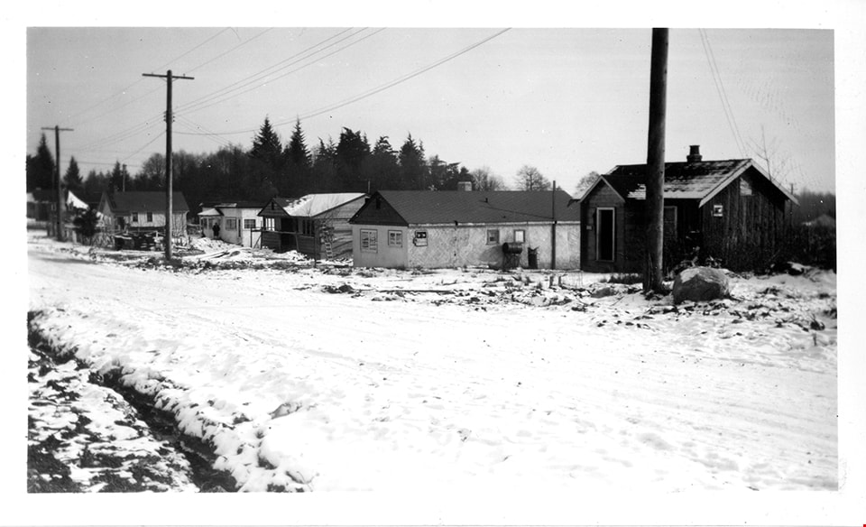
- Photograph of a row of houses on Winch Street in Burnaby. The ground is covered with snow.
- Repository
- Burnaby Village Museum
- Collection/Fonds
- Elmer Wilson Martin fonds
- Description Level
- Item
- Physical Description
- 1 photograph : b&w ; 7 x 11.5 cm
- Scope and Content
- Photograph of a row of houses on Winch Street in Burnaby. The ground is covered with snow.
- Geographic Access
- Winch Street
- Street Address
- 6656 Winch Street
- Accession Code
- BV019.37.26
- Access Restriction
- No restrictions
- Reproduction Restriction
- No known restrictions
- Date
- Jan. 1949
- Media Type
- Photograph
- Scan Resolution
- 600
- Scan Date
- February 4, 2021
- Scale
- 100
- Notes
- Title based on contents of photograph
- Note in blue ink on verso of photograph reads: "Winch St. Program / Jan. 1949"
- Stamp in black ink on verso of photograph reads: "611"
Images
![202 Delta Avenue under construction, [1948] (date of original), copied 1991 thumbnail](/media/hpo/_Data/_Archives_Images/_Unrestricted/370/370-226.jpg?width=280)
202 Delta Avenue under construction
https://search.heritageburnaby.ca/link/archivedescription37638
- Repository
- City of Burnaby Archives
- Date
- [1948] (date of original), copied 1991
- Collection/Fonds
- Burnaby Historical Society fonds
- Description Level
- Item
- Physical Description
- 1 photograph : b&w ; 3.2 x 5.3 cm print on contact sheet 20.2 x 25.3 cm
- Scope and Content
- Photograph of the house at 202 Delta Avenue under construction.
- Repository
- City of Burnaby Archives
- Date
- [1948] (date of original), copied 1991
- Collection/Fonds
- Burnaby Historical Society fonds
- Subseries
- Burnaby Image Bank subseries
- Physical Description
- 1 photograph : b&w ; 3.2 x 5.3 cm print on contact sheet 20.2 x 25.3 cm
- Description Level
- Item
- Record No.
- 370-226
- Access Restriction
- No restrictions
- Reproduction Restriction
- No known restrictions
- Accession Number
- BHS1999-03
- Scope and Content
- Photograph of the house at 202 Delta Avenue under construction.
- Media Type
- Photograph
- Notes
- Title based on contents of photograph
- 1 b&w copy negative accompanying
- Geographic Access
- Delta Avenue
- Street Address
- 202 Delta Avenue
- Historic Neighbourhood
- Capitol Hill (Historic Neighbourhood)
- Planning Study Area
- Capitol Hill Area
Images
![202 Delta Avenue under construction, [1948] (date of original), copied 1991 thumbnail](/media/hpo/_Data/_Archives_Images/_Unrestricted/370/370-226.jpg)
![202 Delta Avenue under construction, [1949] (date of original), copied 1991 thumbnail](/media/hpo/_Data/_Archives_Images/_Unrestricted/370/370-227.jpg?width=280)
202 Delta Avenue under construction
https://search.heritageburnaby.ca/link/archivedescription37639
- Repository
- City of Burnaby Archives
- Date
- [1949] (date of original), copied 1991
- Collection/Fonds
- Burnaby Historical Society fonds
- Description Level
- Item
- Physical Description
- 1 photograph : b&w ; 3.2 x 5.3 cm print on contact sheet 20.2 x 25.3 cm
- Scope and Content
- Photograph of the house at 202 Delta Avenue under construction.
- Repository
- City of Burnaby Archives
- Date
- [1949] (date of original), copied 1991
- Collection/Fonds
- Burnaby Historical Society fonds
- Subseries
- Burnaby Image Bank subseries
- Physical Description
- 1 photograph : b&w ; 3.2 x 5.3 cm print on contact sheet 20.2 x 25.3 cm
- Description Level
- Item
- Record No.
- 370-227
- Access Restriction
- No restrictions
- Reproduction Restriction
- No restrictions
- Accession Number
- BHS1999-03
- Scope and Content
- Photograph of the house at 202 Delta Avenue under construction.
- Media Type
- Photograph
- Notes
- Title based on contents of photograph
- 1 b&w copy negative accompanying
- Geographic Access
- Delta Avenue
- Street Address
- 202 Delta Avenue
- Historic Neighbourhood
- Capitol Hill (Historic Neighbourhood)
- Planning Study Area
- Capitol Hill Area
Images
![202 Delta Avenue under construction, [1949] (date of original), copied 1991 thumbnail](/media/hpo/_Data/_Archives_Images/_Unrestricted/370/370-227.jpg)
![311 Madison Avenue, [1949 or 1950] (date of original), copied 1991 thumbnail](/media/hpo/_Data/_Archives_Images/_Unrestricted/370/370-204.jpg?width=280)
311 Madison Avenue
https://search.heritageburnaby.ca/link/archivedescription37616
- Repository
- City of Burnaby Archives
- Date
- [1949 or 1950] (date of original), copied 1991
- Collection/Fonds
- Burnaby Historical Society fonds
- Description Level
- Item
- Physical Description
- 1 photograph : b&w ; 3.0 x 4.5 cm print on contact sheet 20.2 x 25.3 cm
- Scope and Content
- Photograph of a side view of 311 Madison Avenue, in the snow. The photograph was taken from Madison Avenue.
- Repository
- City of Burnaby Archives
- Date
- [1949 or 1950] (date of original), copied 1991
- Collection/Fonds
- Burnaby Historical Society fonds
- Subseries
- Burnaby Image Bank subseries
- Physical Description
- 1 photograph : b&w ; 3.0 x 4.5 cm print on contact sheet 20.2 x 25.3 cm
- Description Level
- Item
- Record No.
- 370-204
- Access Restriction
- No restrictions
- Reproduction Restriction
- No restrictions
- Accession Number
- BHS1999-03
- Scope and Content
- Photograph of a side view of 311 Madison Avenue, in the snow. The photograph was taken from Madison Avenue.
- Media Type
- Photograph
- Notes
- Title based on contents of photograph
- 1 b&w copy negative accompanying
- Geographic Access
- Madison Avenue
- Street Address
- 311 Madison Avenue
- Historic Neighbourhood
- Vancouver Heights (Historic Neighbourhood)
- Planning Study Area
- Burnaby Heights Area
Images
![311 Madison Avenue, [1949 or 1950] (date of original), copied 1991 thumbnail](/media/hpo/_Data/_Archives_Images/_Unrestricted/370/370-204.jpg)
![311 Madison Avenue, [1941] (date of original), copied 1991 thumbnail](/media/hpo/_Data/_Archives_Images/_Unrestricted/370/370-205.jpg?width=280)
311 Madison Avenue
https://search.heritageburnaby.ca/link/archivedescription37617
- Repository
- City of Burnaby Archives
- Date
- [1941] (date of original), copied 1991
- Collection/Fonds
- Burnaby Historical Society fonds
- Description Level
- Item
- Physical Description
- 1 photograph : b&w ; 4.5 x 3.1 cm print on contact sheet 20.2 x 25.3 cm
- Scope and Content
- Photograph of the front of 311 Madison Avenue, taken from across the street.
- Repository
- City of Burnaby Archives
- Date
- [1941] (date of original), copied 1991
- Collection/Fonds
- Burnaby Historical Society fonds
- Subseries
- Burnaby Image Bank subseries
- Physical Description
- 1 photograph : b&w ; 4.5 x 3.1 cm print on contact sheet 20.2 x 25.3 cm
- Description Level
- Item
- Record No.
- 370-205
- Access Restriction
- No restrictions
- Reproduction Restriction
- No known restrictions
- Accession Number
- BHS1999-03
- Scope and Content
- Photograph of the front of 311 Madison Avenue, taken from across the street.
- Subjects
- Buildings - Residential - Houses
- Media Type
- Photograph
- Notes
- Title based on contents of photograph
- 1 b&w copy negative accompanying
- Geographic Access
- Madison Avenue
- Street Address
- 311 Madison Avenue
- Historic Neighbourhood
- Vancouver Heights (Historic Neighbourhood)
- Planning Study Area
- Burnaby Heights Area
Images
![311 Madison Avenue, [1941] (date of original), copied 1991 thumbnail](/media/hpo/_Data/_Archives_Images/_Unrestricted/370/370-205.jpg)
![1007 Gilley Avenue, [1949 or 1950] (date of original), copied 1991 thumbnail](/media/hpo/_Data/_Archives_Images/_Unrestricted/370/370-667.jpg?width=280)
1007 Gilley Avenue
https://search.heritageburnaby.ca/link/archivedescription38080
- Repository
- City of Burnaby Archives
- Date
- [1949 or 1950] (date of original), copied 1991
- Collection/Fonds
- Burnaby Historical Society fonds
- Description Level
- Item
- Physical Description
- 1 photograph : b&w ; 3.0 x 3.0 cm print on contact sheet 20.2 x 26.2 cm
- Scope and Content
- Photograph of the back of 1007 Gilley Avenue (later renumbered 8416 Gilley Avenue).
- Repository
- City of Burnaby Archives
- Date
- [1949 or 1950] (date of original), copied 1991
- Collection/Fonds
- Burnaby Historical Society fonds
- Subseries
- Burnaby Image Bank subseries
- Physical Description
- 1 photograph : b&w ; 3.0 x 3.0 cm print on contact sheet 20.2 x 26.2 cm
- Description Level
- Item
- Record No.
- 370-667
- Access Restriction
- No restrictions
- Reproduction Restriction
- No restrictions
- Accession Number
- BHS1999-03
- Scope and Content
- Photograph of the back of 1007 Gilley Avenue (later renumbered 8416 Gilley Avenue).
- Subjects
- Buildings - Residential - Houses
- Media Type
- Photograph
- Notes
- Title based on contents of photograph
- 1 b&w copy negative accompanying
- Negative has a pink cast
- Geographic Access
- Gilley Avenue
- Street Address
- 8416 Gilley Avenue
- Planning Study Area
- Stride Hill Area
Images
![1007 Gilley Avenue, [1949 or 1950] (date of original), copied 1991 thumbnail](/media/hpo/_Data/_Archives_Images/_Unrestricted/370/370-667.jpg)