Narrow Results By
Subject
- Advertising Medium - Signs and Signboards 2
- Aerial Photographs 1
- Agriculture - Crops 1
- Agriculture - Farms 1
- Animals - Dogs 2
- Buildings - Agricultural - Barns 1
- Buildings - Commercial - Grocery Stores 1
- Buildings - Commercial - Restaurants 1
- Buildings - Commercial - Service Stations 1
- Buildings - Commercial - Train Stations 1
- Buildings - Heritage 5
- Buildings - Industrial - Mills 2

Administration Building New Haven Borstal
https://search.heritageburnaby.ca/link/archivedescription93663
- Repository
- City of Burnaby Archives
- Date
- January 15, 1978
- Collection/Fonds
- Burnaby Public Library Contemporary Visual Archive Project
- Description Level
- Item
- Physical Description
- 1 photograph : b&w ; 12.5 x 17.5 cm
- Scope and Content
- Photograph of the exterior of the administration building at the New Haven Borstal Institute. The photograph is taken from across the lawn, facing northwest. A man is looking into the window of the building on the left.
- Repository
- City of Burnaby Archives
- Date
- January 15, 1978
- Collection/Fonds
- Burnaby Public Library Contemporary Visual Archive Project
- Physical Description
- 1 photograph : b&w ; 12.5 x 17.5 cm
- Description Level
- Item
- Record No.
- 556-620
- Access Restriction
- No restrictions
- Reproduction Restriction
- Reproduce for fair dealing purposes only
- Accession Number
- 2017-57
- Scope and Content
- Photograph of the exterior of the administration building at the New Haven Borstal Institute. The photograph is taken from across the lawn, facing northwest. A man is looking into the window of the building on the left.
- Subjects
- Buildings - Public - Detention Facilities
- Buildings - Schools
- Buildings - Heritage
- Government - Provincial Government
- Media Type
- Photograph
- Photographer
- Surridge, Jack
- Notes
- Title taken from project information form
- Accompanied by a project information form and 1 photograph (b&w negative ; 9.5 x 12.5 cm)
- BPL no. 69
- Street Address
- 4520 Marine Drive
- Historic Neighbourhood
- Fraser Arm (Historic Neighbourhood)
- Planning Study Area
- Big Bend Area
Images


Barn near Meadow Avenue
https://search.heritageburnaby.ca/link/archivedescription79687
- Repository
- City of Burnaby Archives
- Date
- September 23, 1976
- Collection/Fonds
- Burnaby Public Library Contemporary Visual Archive Project
- Description Level
- Item
- Physical Description
- 1 photograph : b&w ; 11 x 16 cm mounted on cardboard
- Scope and Content
- Photograph shows a boat inside an old barn near Meadow Avenue and 10th Avenue.
- Repository
- City of Burnaby Archives
- Date
- September 23, 1976
- Collection/Fonds
- Burnaby Public Library Contemporary Visual Archive Project
- Physical Description
- 1 photograph : b&w ; 11 x 16 cm mounted on cardboard
- Description Level
- Item
- Record No.
- 556-383
- Access Restriction
- No restrictions
- Reproduction Restriction
- Reproduce for fair dealing purposes only
- Accession Number
- 2013-13
- Scope and Content
- Photograph shows a boat inside an old barn near Meadow Avenue and 10th Avenue.
- Media Type
- Photograph
- Photographer
- Campbell, Peg
- Notes
- Scope note taken directly from BPL photograph description.
- 1 b&w copy negative : 10 x 12.5 cm accompanying
- Geographic Access
- Meadow Avenue
- 10th Avenue
- Historic Neighbourhood
- Fraser Arm (Historic Neighbourhood)
- Planning Study Area
- Big Bend Area
Images


Burnaby mill fire
https://search.heritageburnaby.ca/link/archivedescription45458
- Repository
- City of Burnaby Archives
- Date
- 1979
- Collection/Fonds
- Columbian Newspaper collection
- Description Level
- Item
- Physical Description
- 1 photograph : b&w ; 17 x 24 cm
- Scope and Content
- Photograph of a Burnaby planner and chipper mill that caught on fire. Two firemen are visible in the foreground, silhouetted against the flames.
- Repository
- City of Burnaby Archives
- Date
- 1979
- Collection/Fonds
- Columbian Newspaper collection
- Physical Description
- 1 photograph : b&w ; 17 x 24 cm
- Description Level
- Item
- Record No.
- 480-353
- Access Restriction
- No restrictions
- Reproduction Restriction
- Reproduce for fair dealing purposes only
- Accession Number
- 2003-02
- Scope and Content
- Photograph of a Burnaby planner and chipper mill that caught on fire. Two firemen are visible in the foreground, silhouetted against the flames.
- Media Type
- Photograph
- Photographer
- Hodge, Craig
- Notes
- Title based on contents of photograph
- Newspaper clipping attached to verso of photograph reads: "BURNABY MILL BURNS ... Burnaby firefighters are silhouetted by flames ripping through a planer and chipper mill early this morning at 5744 Byrne Road. The fire was contained in the main building of the $500,000 mill. Damage has been estimated at $200,000. The cause of the fire is under investigation."
- Geographic Access
- Byrne Road
- Street Address
- 5744 Byrne Road
- Historic Neighbourhood
- Fraser Arm (Historic Neighbourhood)
- Planning Study Area
- Big Bend Area
Images


Byrne Creek
https://search.heritageburnaby.ca/link/archivedescription36107
- Repository
- City of Burnaby Archives
- Date
- February 7, 1979
- Collection/Fonds
- Burnaby Historical Society fonds
- Description Level
- Item
- Physical Description
- 1 photograph : b&w ; 15 x 19.5 cm
- Scope and Content
- Photograph of Byrne Creek at a road's edge.
- Repository
- City of Burnaby Archives
- Date
- February 7, 1979
- Collection/Fonds
- Burnaby Historical Society fonds
- Subseries
- Columbian Newspaper subseries
- Physical Description
- 1 photograph : b&w ; 15 x 19.5 cm
- Description Level
- Item
- Record No.
- 222-030
- Access Restriction
- No restrictions
- Reproduction Restriction
- Reproduce for fair dealing purposes only
- Accession Number
- BHS1989-19
- Scope and Content
- Photograph of Byrne Creek at a road's edge.
- Media Type
- Photograph
- Photographer
- King, Basil
- Notes
- Title based on contents of photograph
- Newspaper clipping glued to verso of photograph reads: "Byrne Creek...fish habitat and a problem for developers."
- Geographic Access
- Byrne Creek
- Historic Neighbourhood
- Fraser Arm (Historic Neighbourhood)
- Planning Study Area
- Big Bend Area
Images

Byrne Flats flood
https://search.heritageburnaby.ca/link/archivedescription36857
- Repository
- City of Burnaby Archives
- Date
- 1948
- Collection/Fonds
- Burnaby Historical Society fonds
- Description Level
- Item
- Physical Description
- 1 photograph : b&w ; 9 x 12 cm print
- Scope and Content
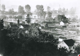
- Photograph of Byrne Flats during the 1948 Fraser River flood.
- Repository
- City of Burnaby Archives
- Date
- 1948
- Collection/Fonds
- Burnaby Historical Society fonds
- Subseries
- Burnaby Centennial Anthology subseries
- Physical Description
- 1 photograph : b&w ; 9 x 12 cm print
- Description Level
- Item
- Record No.
- 315-315
- Access Restriction
- No restrictions
- Reproduction Restriction
- No known restrictions
- Accession Number
- BHS1994-04
- Scope and Content
- Photograph of Byrne Flats during the 1948 Fraser River flood.
- Media Type
- Photograph
- Notes
- Title based on contents of photograph
- Geographic Access
- Trapp Avenue
- Historic Neighbourhood
- Fraser Arm (Historic Neighbourhood)
- Planning Study Area
- Big Bend Area
Images

Byrne Flats flood
https://search.heritageburnaby.ca/link/archivedescription36858
- Repository
- City of Burnaby Archives
- Date
- 1948
- Collection/Fonds
- Burnaby Historical Society fonds
- Description Level
- Item
- Physical Description
- 1 photograph : b&w ; 9 x 12.5 cm print
- Scope and Content
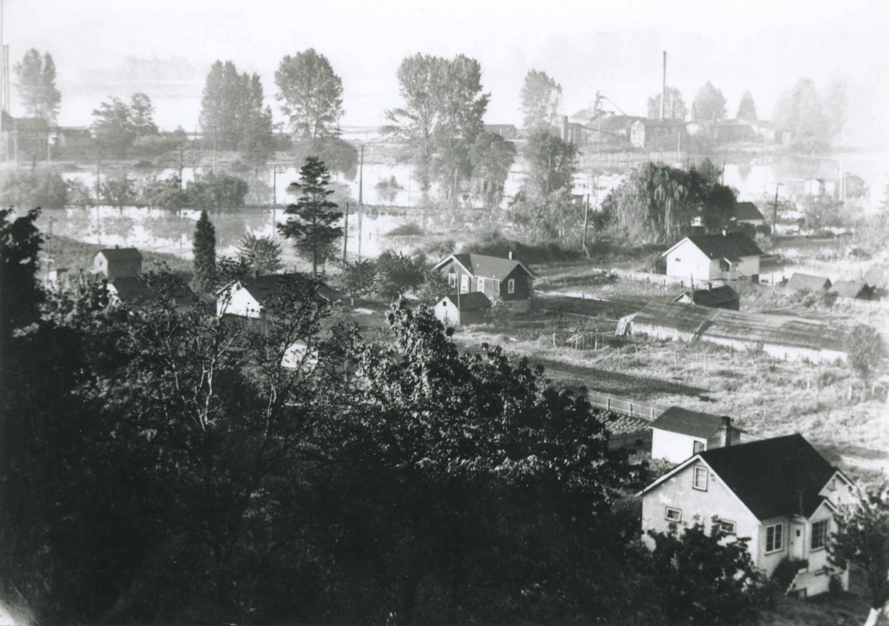
- Photograph of Byrne Flats during the 1948 Fraser River flood.
- Repository
- City of Burnaby Archives
- Date
- 1948
- Collection/Fonds
- Burnaby Historical Society fonds
- Subseries
- Burnaby Centennial Anthology subseries
- Physical Description
- 1 photograph : b&w ; 9 x 12.5 cm print
- Description Level
- Item
- Record No.
- 315-316
- Access Restriction
- No restrictions
- Reproduction Restriction
- No known restrictions
- Accession Number
- BHS1994-04
- Scope and Content
- Photograph of Byrne Flats during the 1948 Fraser River flood.
- Media Type
- Photograph
- Notes
- Title based on contents of photograph
- Geographic Access
- Trapp Avenue
- Historic Neighbourhood
- Fraser Arm (Historic Neighbourhood)
- Planning Study Area
- Big Bend Area
Images

![Chan Kow Hong harvesting cauliflower at Hop-On Farm, [between 1975 and 1979] (date of original), copied 2017 thumbnail](/media/hpo/_Data/_BVM_Images/2017/2017_0036_0013_001.jpg?width=280)
Chan Kow Hong harvesting cauliflower at Hop-On Farm
https://search.heritageburnaby.ca/link/museumdescription4262
- Repository
- Burnaby Village Museum
- Date
- [between 1975 and 1979] (date of original), copied 2017
- Collection/Fonds
- Burnaby Village Museum Photograph collection
- Description Level
- Item
- Physical Description
- 1 photograph : colour : copy scan
- Scope and Content
- Photograph of Chan Kow Hong standing in a field, harvesting cauliflower at Hop-On Farm. Chan Kow Hong is wearing a beige cap and a white T-shirt. White greenhouse and trees in background.
- Repository
- Burnaby Village Museum
- Collection/Fonds
- Burnaby Village Museum Photograph collection
- Description Level
- Item
- Physical Description
- 1 photograph : colour : copy scan
- Scope and Content
- Photograph of Chan Kow Hong standing in a field, harvesting cauliflower at Hop-On Farm. Chan Kow Hong is wearing a beige cap and a white T-shirt. White greenhouse and trees in background.
- History
- Josephine Hong was born to Sui Ha Hong and Chan Kow Hong. The Hong Family had seven children, oldest to youngest: Pauline, Josephine, Catherine, Norine, Gary, Darlene, and Marlene. The family runs Hop-On Farm on Marine Drive in Burnaby. Many Hong family members worked on the farm including Josephine Hong's grandfather, Gay Tim Hong, and uncles. Her great-grandfather was Sui Wing Hong
- Subjects
- Persons - Chinese Canadians
- Names
- Hop On Farms
- Hong, Chan Kow
- Geographic Access
- Byrne Road
- Accession Code
- BV017.36.13
- Access Restriction
- No restrictions
- Reproduction Restriction
- May be restricted by third party rights
- Date
- [between 1975 and 1979] (date of original), copied 2017
- Media Type
- Photograph
- Historic Neighbourhood
- Fraser Arm (Historic Neighbourhood)
- Related Material
- See Oral History Interview-BV020.6.1
- Scan Resolution
- 800
- Scan Date
- 12/3/2017
- Scale
- 100
- Notes
- Title based on contents of photograph.
Images
![Chan Kow Hong harvesting cauliflower at Hop-On Farm, [between 1975 and 1979] (date of original), copied 2017 thumbnail](/media/hpo/_Data/_BVM_Images/2017/2017_0036_0013_001.jpg)

Chinese Market Gardens
https://search.heritageburnaby.ca/link/archivedescription70542
- Repository
- City of Burnaby Archives
- Date
- 1949
- Collection/Fonds
- Gail Yip fonds
- Description Level
- Item
- Physical Description
- 1 photograph (jpeg) : b&w
- Scope and Content
- Photograph is an aerial view looking south over the Chinese Market Gardens along Marine Drive. The farm on the south side of Marine Drive, second from the east, is 4930 Marine Drive.
- Repository
- City of Burnaby Archives
- Date
- 1949
- Collection/Fonds
- Gail Yip fonds
- Physical Description
- 1 photograph (jpeg) : b&w
- Description Level
- Item
- Record No.
- 529-001
- Access Restriction
- No restrictions
- Reproduction Restriction
- Reproduce for fair dealing purposes only
- Accession Number
- 2012-04
- Scope and Content
- Photograph is an aerial view looking south over the Chinese Market Gardens along Marine Drive. The farm on the south side of Marine Drive, second from the east, is 4930 Marine Drive.
- Subjects
- Agriculture - Crops
- Agriculture - Farms
- Names
- Chinese Market Gardens
- Media Type
- Photograph
- Geographic Access
- Marine Drive
- Street Address
- 4930 Marine Drive
- Historic Neighbourhood
- Fraser Arm (Historic Neighbourhood)
- Planning Study Area
- Big Bend Area
Images

![Darlene Hong and Marlene Hong on Hop-On Farm, [between 1975 and 1979] (date of original), copied 2017 thumbnail](/media/hpo/_Data/_BVM_Images/2017/2017_0036_0015_001.jpg?width=280)
Darlene Hong and Marlene Hong on Hop-On Farm
https://search.heritageburnaby.ca/link/museumdescription4264
- Repository
- Burnaby Village Museum
- Date
- [between 1975 and 1979] (date of original), copied 2017
- Collection/Fonds
- Burnaby Village Museum Photograph collection
- Description Level
- Item
- Physical Description
- 1 photograph : colour : copy scan
- Scope and Content
- Photograph of Darlene Hong (L) and Marlene Hong (R) standing in field with rakes on Hop-On Farm.
- Repository
- Burnaby Village Museum
- Collection/Fonds
- Burnaby Village Museum Photograph collection
- Description Level
- Item
- Physical Description
- 1 photograph : colour : copy scan
- Scope and Content
- Photograph of Darlene Hong (L) and Marlene Hong (R) standing in field with rakes on Hop-On Farm.
- History
- Josephine Hong was born to Sui Ha Hong and Chan Kow Hong. The Hong Family had seven children, oldest to youngest: Pauline, Josephine, Catherine, Norine, Gary, Darlene, and Marlene. The family runs Hop-On Farm on Marine Drive in Burnaby. Many Hong family members worked on the farm including Josephine Hong's grandfather, Gay Tim Hong, and uncles. Her great-grandfather was Sui Wing Hong
- Subjects
- Persons - Chinese Canadians
- Geographic Access
- Byrne Road
- Accession Code
- BV017.36.15
- Access Restriction
- No restrictions
- Reproduction Restriction
- May be restricted by third party rights
- Date
- [between 1975 and 1979] (date of original), copied 2017
- Media Type
- Photograph
- Historic Neighbourhood
- Fraser Arm (Historic Neighbourhood)
- Related Material
- See Oral History Interview-BV020.6.1
- Scan Resolution
- 800
- Scan Date
- 12/3/2017
- Scale
- 100
- Notes
- Title based on contents of photograph.
Images
![Darlene Hong and Marlene Hong on Hop-On Farm, [between 1975 and 1979] (date of original), copied 2017 thumbnail](/media/hpo/_Data/_BVM_Images/2017/2017_0036_0015_001.jpg)
![Dolores Dyck, Helen Silvanovicz and Norma Rypdal, [1944] (date of original), copied 1992 thumbnail](/media/hpo/_Data/_Archives_Images/_Unrestricted/315/315-310.jpg?width=280)
Dolores Dyck, Helen Silvanovicz and Norma Rypdal
https://search.heritageburnaby.ca/link/archivedescription36852
- Repository
- City of Burnaby Archives
- Date
- [1944] (date of original), copied 1992
- Collection/Fonds
- Burnaby Historical Society fonds
- Description Level
- Item
- Physical Description
- 1 photograph : b&w ; 8 x 12 cm print
- Scope and Content
- Photograph of Dolores Dyck, Helen Silvanovicz and Norma Rypdal at the Connaught Hill Interurban tram station on their way to Burnaby South High School.
- Repository
- City of Burnaby Archives
- Date
- [1944] (date of original), copied 1992
- Collection/Fonds
- Burnaby Historical Society fonds
- Subseries
- Burnaby Centennial Anthology subseries
- Physical Description
- 1 photograph : b&w ; 8 x 12 cm print
- Description Level
- Item
- Record No.
- 315-310
- Access Restriction
- No restrictions
- Reproduction Restriction
- No known restrictions
- Accession Number
- BHS1994-04
- Scope and Content
- Photograph of Dolores Dyck, Helen Silvanovicz and Norma Rypdal at the Connaught Hill Interurban tram station on their way to Burnaby South High School.
- Names
- Dyck, Dolores
- Moysiuk, Helen Silvanovicz
- Perry, Norma Rypdal
- British Columbia Electric Railway Company
- Media Type
- Photograph
- Notes
- Title based on contents of photograph;
- Geographic Access
- Central Park Interurban line
- Historic Neighbourhood
- Fraser Arm (Historic Neighbourhood)
- Planning Study Area
- Stride Hill Area
- Stride Avenue Area
Images
![Dolores Dyck, Helen Silvanovicz and Norma Rypdal, [1944] (date of original), copied 1992 thumbnail](/media/hpo/_Data/_Archives_Images/_Unrestricted/315/315-310.jpg)

Dr. and Mrs. Morris
https://search.heritageburnaby.ca/link/archivedescription36485
- Repository
- City of Burnaby Archives
- Date
- May 1942
- Collection/Fonds
- Burnaby Historical Society fonds
- Description Level
- Item
- Physical Description
- 1 photograph : b&w ; 12.5 x 8.5 cm print
- Scope and Content
- Photograph of Dr. Wesley Morris and his wife, Laura Maude Weegar Morris standing beside a pathway at Marine Drive.
- Repository
- City of Burnaby Archives
- Date
- May 1942
- Collection/Fonds
- Burnaby Historical Society fonds
- Subseries
- Morris family subseries
- Physical Description
- 1 photograph : b&w ; 12.5 x 8.5 cm print
- Description Level
- Item
- Record No.
- 278-001
- Access Restriction
- No restrictions
- Reproduction Restriction
- No known restrictions
- Accession Number
- BHS1992-08
- Scope and Content
- Photograph of Dr. Wesley Morris and his wife, Laura Maude Weegar Morris standing beside a pathway at Marine Drive.
- Media Type
- Photograph
- Notes
- Title based on contents of photograph
- Geographic Access
- Marine Drive
- Historic Neighbourhood
- Fraser Arm (Historic Neighbourhood)
- Planning Study Area
- Big Bend Area
- Sussex-Nelson Area
Images
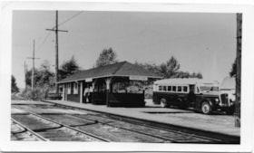
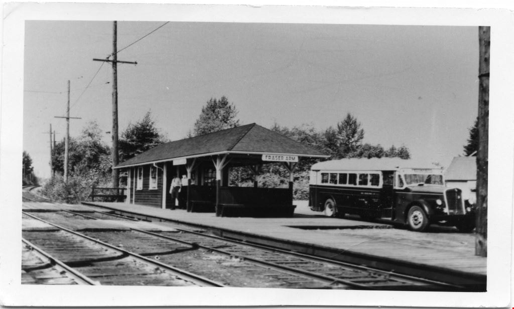
Fraser Arm rail and bus station
https://search.heritageburnaby.ca/link/museumdescription4782
- Repository
- Burnaby Village Museum
- Date
- 1930-1950
- Collection/Fonds
- Burnaby Village Museum Photograph collection
- Description Level
- Item
- Physical Description
- 1 photograph : b&w ; 6.7 x 11.4 cm ; copy print
- Scope and Content
- From left railtracks, power line, rail station shelter with man, station platform, bus facing right. Shelter has 'Fraser Arm' sign. Bus has 'BC Electric' lettered on side.
- Repository
- Burnaby Village Museum
- Collection/Fonds
- Burnaby Village Museum Photograph collection
- Description Level
- Item
- Physical Description
- 1 photograph : b&w ; 6.7 x 11.4 cm ; copy print
- Scope and Content
- From left railtracks, power line, rail station shelter with man, station platform, bus facing right. Shelter has 'Fraser Arm' sign. Bus has 'BC Electric' lettered on side.
- History
- Part of a set of photographs from the Columbian Newspaper, which operated out of New Westminster under this name starting in 1900 until its dissolution in 1988. Photographs found in the collection of the Burnaby Village are dated 1971.
- Other Title Information
- title based on content of photograph
- Accession Code
- BV018.19.8
- Access Restriction
- No restrictions
- Reproduction Restriction
- May be restricted by third party rights
- Date
- 1930-1950
- Media Type
- Photograph
- Historic Neighbourhood
- Fraser Arm (Historic Neighbourhood)
- Scan Resolution
- 600
- Scan Date
- 24-04-2018
Images

Glenwood Service Station
https://search.heritageburnaby.ca/link/archivedescription79264
- Repository
- City of Burnaby Archives
- Date
- November 14, 1976
- Collection/Fonds
- Burnaby Public Library Contemporary Visual Archive Project
- Description Level
- Item
- Physical Description
- 1 photograph : b&w ; 11 x 16 cm mounted on cardboard
- Scope and Content
- Photograph shows a view from Gilley Avenue of the Glenwood Service Station at 5894 Marine Drive.
- Repository
- City of Burnaby Archives
- Date
- November 14, 1976
- Collection/Fonds
- Burnaby Public Library Contemporary Visual Archive Project
- Physical Description
- 1 photograph : b&w ; 11 x 16 cm mounted on cardboard
- Description Level
- Item
- Record No.
- 556-228
- Access Restriction
- No restrictions
- Reproduction Restriction
- Reproduce for fair dealing purposes only
- Accession Number
- 2013-13
- Scope and Content
- Photograph shows a view from Gilley Avenue of the Glenwood Service Station at 5894 Marine Drive.
- Names
- Glenwood Service Station
- Media Type
- Photograph
- Photographer
- Campbell, Peg
- Notes
- Scope note taken directly from BPL photograph description.
- 1 b&w copy negative : 10 x 12.5 cm accompanying
- Geographic Access
- Marine Drive
- Street Address
- 5894 Marine Drive
- Historic Neighbourhood
- Fraser Arm (Historic Neighbourhood)
- Planning Study Area
- Big Bend Area
Images

![Horse-drawn carriage on Marine Drive, [1944] thumbnail](/media/hpo/_Data/_Archives_Images/_Unrestricted/251/275-010.jpg?width=280)
Horse-drawn carriage on Marine Drive
https://search.heritageburnaby.ca/link/archivedescription36478
- Repository
- City of Burnaby Archives
- Date
- [1944]
- Collection/Fonds
- Burnaby Historical Society fonds
- Description Level
- Item
- Physical Description
- 1 photograph : b&w ; 8.5 x 12.5 cm print
- Scope and Content
- Photograph of a man driving a boy along Marine Drive in a small "trap", or light-weight, two-wheeled horse-drawn carriage.
- Repository
- City of Burnaby Archives
- Date
- [1944]
- Collection/Fonds
- Burnaby Historical Society fonds
- Subseries
- Thrussell family subseries
- Physical Description
- 1 photograph : b&w ; 8.5 x 12.5 cm print
- Description Level
- Item
- Record No.
- 275-010
- Access Restriction
- No restrictions
- Reproduction Restriction
- No known restrictions
- Accession Number
- BHS1992-05
- Scope and Content
- Photograph of a man driving a boy along Marine Drive in a small "trap", or light-weight, two-wheeled horse-drawn carriage.
- Media Type
- Photograph
- Notes
- Title based on contents of photograph
- Geographic Access
- Marine Drive
- Historic Neighbourhood
- Fraser Arm (Historic Neighbourhood)
- Planning Study Area
- Big Bend Area
- Sussex-Nelson Area
Images
![Horse-drawn carriage on Marine Drive, [1944] thumbnail](/media/hpo/_Data/_Archives_Images/_Unrestricted/251/275-010.jpg)

Marine Food Basket
https://search.heritageburnaby.ca/link/archivedescription79097
- Repository
- City of Burnaby Archives
- Date
- November 14, 1976
- Collection/Fonds
- Burnaby Public Library Contemporary Visual Archive Project
- Description Level
- Item
- Physical Description
- 1 photograph : b&w ; 11 x 16 cm mounted on cardboard
- Scope and Content
- Photograph shows a large truck going past the Marine Food Basket at 5886 Marine Drive and the Hawaii Cafe next door. The buildings were constructed around 1930.
- Repository
- City of Burnaby Archives
- Date
- November 14, 1976
- Collection/Fonds
- Burnaby Public Library Contemporary Visual Archive Project
- Physical Description
- 1 photograph : b&w ; 11 x 16 cm mounted on cardboard
- Description Level
- Item
- Record No.
- 556-150
- Access Restriction
- No restrictions
- Reproduction Restriction
- Reproduce for fair dealing purposes only
- Accession Number
- 2013-13
- Scope and Content
- Photograph shows a large truck going past the Marine Food Basket at 5886 Marine Drive and the Hawaii Cafe next door. The buildings were constructed around 1930.
- Media Type
- Photograph
- Photographer
- Campbell, Peg
- Notes
- Scope note taken directly from BPL photograph description.
- 1 b&w copy negative : 10 x 12.5 cm accompanying
- Geographic Access
- Marine Drive
- Street Address
- 5886 Marine Drive
- Historic Neighbourhood
- Fraser Arm (Historic Neighbourhood)
- Planning Study Area
- Big Bend Area
Images


Marine Way and Willard Street
https://search.heritageburnaby.ca/link/archivedescription79912
- Repository
- City of Burnaby Archives
- Date
- November, 1976
- Collection/Fonds
- Burnaby Public Library Contemporary Visual Archive Project
- Description Level
- Item
- Physical Description
- 1 photograph : b&w ; 11 x 16 cm mounted on cardboard
- Scope and Content
- Photograph shows a collection of signboards on the corner of Marine Way and Willard Street.
- Repository
- City of Burnaby Archives
- Date
- November, 1976
- Collection/Fonds
- Burnaby Public Library Contemporary Visual Archive Project
- Physical Description
- 1 photograph : b&w ; 11 x 16 cm mounted on cardboard
- Description Level
- Item
- Record No.
- 556-494
- Access Restriction
- No restrictions
- Reproduction Restriction
- Reproduce for fair dealing purposes only
- Accession Number
- 2013-13
- Scope and Content
- Photograph shows a collection of signboards on the corner of Marine Way and Willard Street.
- Media Type
- Photograph
- Photographer
- Campbell, Peg
- Notes
- Scope note taken directly from BPL photograph description.
- 1 b&w copy negative : 10 x 12.5 cm accompanying
- Geographic Access
- Marine Way
- Willard Street
- Historic Neighbourhood
- Fraser Arm (Historic Neighbourhood)
- Planning Study Area
- Big Bend Area
Images

Marshland Avenue
https://search.heritageburnaby.ca/link/archivedescription79982
- Repository
- City of Burnaby Archives
- Date
- September 23, 1976
- Collection/Fonds
- Burnaby Public Library Contemporary Visual Archive Project
- Description Level
- Item
- Physical Description
- 1 photograph : b&w ; 11 x 16 cm mounted on cardboard
- Scope and Content
- Photograph shows a view looking northeast along Marshland Avenue, near Wiggins Street.
- Repository
- City of Burnaby Archives
- Date
- September 23, 1976
- Collection/Fonds
- Burnaby Public Library Contemporary Visual Archive Project
- Physical Description
- 1 photograph : b&w ; 11 x 16 cm mounted on cardboard
- Description Level
- Item
- Record No.
- 556-538
- Access Restriction
- No restrictions
- Reproduction Restriction
- Reproduce for fair dealing purposes only
- Accession Number
- 2013-13
- Scope and Content
- Photograph shows a view looking northeast along Marshland Avenue, near Wiggins Street.
- Media Type
- Photograph
- Photographer
- Campbell, Peg
- Notes
- Scope note taken directly from BPL photograph description.
- 1 b&w copy negative : 10 x 12.5 cm accompanying
- Geographic Access
- Marshland Avenue
- Historic Neighbourhood
- Fraser Arm (Historic Neighbourhood)
- Planning Study Area
- Big Bend Area
Images

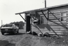
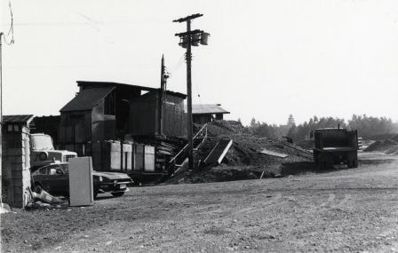
Meadowland Peat Limited
https://search.heritageburnaby.ca/link/archivedescription79357
- Repository
- City of Burnaby Archives
- Date
- September 23, 1976
- Collection/Fonds
- Burnaby Public Library Contemporary Visual Archive Project
- Description Level
- Item
- Physical Description
- 1 photograph : b&w ; 11 x 16 cm mounted on cardboard
- Scope and Content
- Photograph shows the sales office of Meadowland Peat Limited at 7625 Meadow Avenue.
- Repository
- City of Burnaby Archives
- Date
- September 23, 1976
- Collection/Fonds
- Burnaby Public Library Contemporary Visual Archive Project
- Physical Description
- 1 photograph : b&w ; 11 x 16 cm mounted on cardboard
- Description Level
- Item
- Record No.
- 556-264
- Access Restriction
- No restrictions
- Reproduction Restriction
- Reproduce for fair dealing purposes only
- Accession Number
- 2013-13
- Scope and Content
- Photograph shows the sales office of Meadowland Peat Limited at 7625 Meadow Avenue.
- Names
- Meadowland Peat Limited
- Media Type
- Photograph
- Photographer
- Campbell, Peg
- Notes
- Scope note taken directly from BPL photograph description.
- 1 b&w copy negative : 10 x 12.5 cm accompanying
- Geographic Access
- Meadow Avenue
- Street Address
- 7625 Meadow Avenue
- Historic Neighbourhood
- Fraser Arm (Historic Neighbourhood)
- Planning Study Area
- Big Bend Area
Images


Meadowland Peat Limited
https://search.heritageburnaby.ca/link/archivedescription79358
- Repository
- City of Burnaby Archives
- Date
- September 23, 1976
- Collection/Fonds
- Burnaby Public Library Contemporary Visual Archive Project
- Description Level
- Item
- Physical Description
- 1 photograph : b&w ; 11 x 16 cm mounted on cardboard
- Scope and Content
- Photograph shows a construction site and building behind the sales office of Meadowland Peat Limited at 7625 Meadow Avenue. Meadowland Farms owned the site prior to 1974.
- Repository
- City of Burnaby Archives
- Date
- September 23, 1976
- Collection/Fonds
- Burnaby Public Library Contemporary Visual Archive Project
- Physical Description
- 1 photograph : b&w ; 11 x 16 cm mounted on cardboard
- Description Level
- Item
- Record No.
- 556-265
- Access Restriction
- No restrictions
- Reproduction Restriction
- Reproduce for fair dealing purposes only
- Accession Number
- 2013-13
- Scope and Content
- Photograph shows a construction site and building behind the sales office of Meadowland Peat Limited at 7625 Meadow Avenue. Meadowland Farms owned the site prior to 1974.
- Names
- Meadowland Peat Limited
- Media Type
- Photograph
- Photographer
- Campbell, Peg
- Notes
- Scope note taken directly from BPL photograph description.
- 1 b&w copy negative : 10 x 12.5 cm accompanying
- Geographic Access
- Meadow Avenue
- Street Address
- 7625 Meadow Avenue
- Historic Neighbourhood
- Fraser Arm (Historic Neighbourhood)
- Planning Study Area
- Big Bend Area
Images
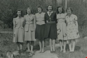
Morris daughters
https://search.heritageburnaby.ca/link/archivedescription36487
- Repository
- City of Burnaby Archives
- Date
- May 1942
- Collection/Fonds
- Burnaby Historical Society fonds
- Description Level
- Item
- Physical Description
- 1 photograph : b&w ; 12.5 x 8.5 cm print
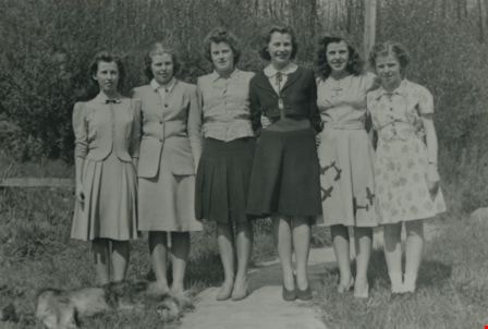
- Scope and Content
- Photograph of the Morris daughters standing on a pathway at Marine Drive, in a row from eldest to youngest: Margaret Janet (eldest), Laura Elizabeth (Betty), Dorothy Rhoda Adelaide, Jessie Ellen, Gertrude Kathleen, to Mureil (youngest). Their dog Nemo is lying at their feet.
- Repository
- City of Burnaby Archives
- Date
- May 1942
- Collection/Fonds
- Burnaby Historical Society fonds
- Subseries
- Morris family subseries
- Physical Description
- 1 photograph : b&w ; 12.5 x 8.5 cm print
- Description Level
- Item
- Record No.
- 278-003
- Access Restriction
- No restrictions
- Reproduction Restriction
- No known restrictions
- Accession Number
- BHS1992-08
- Scope and Content
- Photograph of the Morris daughters standing on a pathway at Marine Drive, in a row from eldest to youngest: Margaret Janet (eldest), Laura Elizabeth (Betty), Dorothy Rhoda Adelaide, Jessie Ellen, Gertrude Kathleen, to Mureil (youngest). Their dog Nemo is lying at their feet.
- Subjects
- Animals - Dogs
- Names
- Sheldon, Margaret Janet Morris
- Morris, Laura Elizabeth "Betty"
- Morris, Dorothy Rhoda Adelaide
- Morris, Jessie Ellen
- Morris, Gertrude Kathleen
- Morris, Muriel
- Media Type
- Photograph
- Notes
- Title based on contents of photograph
- Geographic Access
- Marine Drive
- Historic Neighbourhood
- Fraser Arm (Historic Neighbourhood)
- Planning Study Area
- Big Bend Area
- Sussex-Nelson Area
Images