Narrow Results By
Decade
- 2020s
- 2010s 152
- 2000s 1828
- 1990s
- 1980s 1366
- 1970s 3518
- 1960s
- 1950s 1712
- 1940s
- 1930s 2159
- 1920s 2489
- 1910s 2036
- 1900s 869
- 1890s 250
- 1880s 165
- 1870s 72
- 1860s 123
- 1850s 14
- 1840s 5
- 1830s 3
- 1820s 2
- 1810s 3
- 1800s 3
- 1790s 2
- 1780s 2
- 1770s 2
- 1760s 2
- 1750s 2
- 1740s 2
- 1730s 2
- 1720s 2
- 1710s 2
- 1700s 2
- 1690s 2
- 1680s 2
- 1670s 1
- 1660s 1
- 1650s 1
- 1640s 1
- 1630s 1
- 1620s 1
- 1610s 1
- 1600s 1
- 1590s 1
- 1580s 1
- 1570s 1
- 1560s 1
- 1550s 1
- 1540s 1
- 1530s 1
- 1520s 2
- 1510s 1
- 1500s 1
- 1490s 1
- 1480s 1
Subject
- Accidents 2
- Accidents - Automobile Accidents 17
- Accidents - Train Accidents 7
- Adornment - Jewelry 1
- Advertising Medium 2
- Advertising Medium - Poster 1
- Advertising Medium - Signs and Signboards 80
- Aerial Photographs 19
- Agricultural Tools and Equipment 6
- Agricultural Tools and Equipment - Cultivators 2
- Agricultural Tools and Equipment - Gardening Equipment 2
- Agricultural Tools and Equipment - Plows 4

Second Street Neighbourhood
https://search.heritageburnaby.ca/link/landmark826
- Repository
- Burnaby Heritage Planning
- Associated Dates
- 1955-2008
- Heritage Value
- Second Street had its origins in the 1910-1920 era and the Second Street Elementary School was built in 1928. Substantial new housing was built in the late 1940s and 1950s and infilling occurred during the 1960s and 1970s. By the 1980s, the neighbourhood was primarily a single family area with a small number of multi-family buildings.
- Historic Neighbourhood
- East Burnaby (Historic Neighbourhood)
- Planning Study Area
- Second Street Area
Images


Shadbolt Centre for the Arts
https://search.heritageburnaby.ca/link/landmark820
- Repository
- Burnaby Heritage Planning
- Geographic Access
- Deer Lake Avenue
- Associated Dates
- 1995
- Heritage Value
- The Shadbolt Centre for the Arts opened in 1995. The Shadbolt Centre was named after two Burnaby residents who dedicated a lifetime of support and cultivation of the arts locally, nationally and internationally. Doris and Jack Shadbolt resided in Burnaby for over 50 years until Jack's death in November 1998. Doris Shadbolt spent her life's work bringing the artist and the audience closer together through her writing and curatorial work. Jack Shadbolt was an internationally recognized Canadian painter. He was also an author and both received many awards including the Order of Canada. In keeping with the Shadbolts' generosity the arts, Jack Shadbolt donated two of his paintings to the Centre for permanent display.
- Historic Neighbourhood
- Burnaby Lake (Historic Neighbourhood)
- Planning Study Area
- Douglas-Gilpin Area
- Street Address
- 6450 Deer Lake Avenue
- Street View URL
- Google Maps Street View
Images


Shell Oil Company
https://search.heritageburnaby.ca/link/landmark675
- Repository
- Burnaby Heritage Planning
- Geographic Access
- Kensington Avenue
- Associated Dates
- ca. 1930-1993
- Heritage Value
- After considering several sites in the Greater Vancouver area, the Shell Oil Company chose 70 acres in North Burnaby with frontage of one third of a mile on Burrard Inlet. Shell proposed to build a four-million dollar plant that would employ up to 2000 - providing some relief in the middle of Burnaby's economic crisis of the Depression years. The site became known as the Shellburn Refinery and was in operation until 1993.
- Historic Neighbourhood
- Lochdale (Historic Neighbourhood)
- Planning Study Area
- Westridge Area
Images


Simon Fraser University
https://search.heritageburnaby.ca/link/landmark639
- Repository
- Burnaby Heritage Planning
- Description
- The planning, design concept, design coordination, site development and landscaping for the original part of the campus were all under the control of Erickson/Massey. The complex was conceived as one building, with future growth occurring at the periphery. Tall buildings would have been out of scal…
- Associated Dates
- 1965
- Street View URL
- Google Maps Street View
- Repository
- Burnaby Heritage Planning
- Geographic Access
- University Drive
- Associated Dates
- 1965
- Description
- The planning, design concept, design coordination, site development and landscaping for the original part of the campus were all under the control of Erickson/Massey. The complex was conceived as one building, with future growth occurring at the periphery. Tall buildings would have been out of scale with the massive mountaintop ridge, so a series of horizontal terraced structures were designed that hugged the ridge and dissolve into the landscape. Following the linear peak of the mountain, the scheme organized various parts of the campus along an east/west line. The concept of a central academic quadrangle was conceived within the tradition of Oxford and Cambridge, and to enhance the sense of contemplative quiet, it was designed as a perfect square raised on massive pilotis, allowing stunning views through a landscaped courtyard. The connecting link was a gigantic space frame-developed in conjunction with Jeffrey Lindsay, a one-time associate of Buckminster Fuller-that provided shelter and a gathering-place for the students. Other architects who had placed among the top five in the competition were retained to design the individual components of the original plan: the Academic Quadrangle by Zoltan S. Kiss; the Theatre, Gymnasium & Swimming Pool by Duncan McNab & Associates; the Science Complex by Rhone & Iredale; and the Library by Robert F. Harrison.
- Heritage Value
- Following the end of the Second World War, there was unprecedented growth throughout the Lower Mainland. Many returning veterans had settled on the coast, and the loosening of wartime restrictions led to the creation of many new suburban developments throughout the region. The growing population strained existing facilities, and there was a recognition that new educational facilities had to be constructed to meet these growing demands. For many years, the only university in the province was the University of British Columbia. In the 1960s, new universities were planned for both Victoria and Burnaby to serve the wave of baby boomers just then going through high school. The dramatic site chosen for the Burnaby university was the top of Burnaby Mountain, with expansive views over mountain ranges and water. An architectural competition was held for a campus of 7,000 students that could eventually be expanded to 18,000. Of the many submissions, the judges reached unanimity on the winner, an outstanding scheme submitted by the firm of Erickson/Massey. The judges went even further, and recommended that every effort be made to ensure that the winning design be built as submitted. The new Chancellor, Gordon Shrum, agreed. The realization of this scheme won extensive recognition for the work of Arthur Erickson and Geoffrey Massey, and launched Erickson’s international career. In Erickson’s words: "Unlike any previous university, Simon Fraser is a direct translation into architecture of the expanding fields of knowledge that defy traditional boundaries, of the vital role of the university as both challenger and conservor of human culture, and of the university community as one in constant intellectual, spiritual and social interchange." The new school opened for classes in September 1965, nicknamed the “instant university,” and quickly gained a radical reputation. The startling futuristic architecture and open layout suited the explosive nature of the mid-1960s, when political and social traditions of all types were being questioned and student protests were common. Many of SFU’s programs were considered experimental, even controversial, and unrest and conflict on the campus continued for a number of years. Since this auspicious beginning 40 years ago, SFU has grown to house 25,000 students on three campuses. The core of the original campus, recognized world-wide as a profound work of architecture, remains essentially intact today.
- Locality
- Burnaby Mountain
- Historic Neighbourhood
- Barnet (Historic Neighbourhood)
- Planning Study Area
- Burnaby Mountain Area
- Architect
- Erickson/Massey
- Area
- 1360000.00
- Contributing Resource
- Building
- Ownership
- Private
- Street Address
- 8888 University Drive
- Street View URL
- Google Maps Street View
Images


South Slope Elementary School & The B.C. Provincial School for the Deaf
https://search.heritageburnaby.ca/link/landmark843
- Repository
- Burnaby Heritage Planning
- Geographic Access
- Watling Street
- Associated Dates
- 1992
- Heritage Value
- South Slope/B.C. School for the Deaf opened in 1992 and is one of the newer elementary schools in the City. The 2009 School Growth Plan notes that South Slope/BC School for the Deaf replaced the former Jericho Hill School for the Deaf in Vancouver.
- Historic Neighbourhood
- Alta Vista (Historic Neighbourhood)
- Planning Study Area
- Sussex-Nelson Area
- Street Address
- 4446 Watling Street
- Street View URL
- Google Maps Street View
Images


Sperling-Broadway Neighbourhood
https://search.heritageburnaby.ca/link/landmark789
- Repository
- Burnaby Heritage Planning
- Associated Dates
- 1955-2008
- Heritage Value
- By the 1970s, the Sperling-Broadway Neighbourhood was characterised as one of the Municipality's fastest growing residential areas. In 1980, it was estimated that slightly less than half of the homes were single-family residences, while the remaining development was taking the form of townhouse and high-rise apartments. The emphasis shifted back to single family housing during the construction of planned subdivisions such as the Camrose subdivision in the 1980s and the area remains primarily residential in nature. The neighbourhood is well-served by park facilities and is also home to the Burnaby Mountain Golf Course.
- Historic Neighbourhood
- Lochdale (Historic Neighbourhood)
- Planning Study Area
- Sperling-Broadway Area
Images


Stride Avenue Neighbourhood
https://search.heritageburnaby.ca/link/landmark845
- Repository
- Burnaby Heritage Planning
- Associated Dates
- 1955-2008
- Heritage Value
- The interurban link between New Westminster and Vancouver stimulated the early settlement of Stride Avenue. Infilling of the area took place in the early 1950s and the pace of development had slowed considerably by 1970. Duplexes became a popular feature in the decade between 1970 and 1980 and in the late 1980s, the neighbourhood was incorporated into the Edmonds Town Centre South plan.
- Historic Neighbourhood
- Edmonds (Historic Neighbourhood)
- Planning Study Area
- Stride Avenue Area
Images


Stride Hill Neighbourhood
https://search.heritageburnaby.ca/link/landmark846
- Repository
- Burnaby Heritage Planning
- Associated Dates
- 1955-2008
- Heritage Value
- The residential areas that are located within the Stride Hill Neighbourhood were primarily developed in the 1950s during Burnaby's post-war building boom. The area lying to the south of Byrne Creek Ravine Park was used as a municipal garbage dump until the 1960s and as a landfill site for yard waste disposal until the early 1990s at which point the area was incorporated into the Edmonds Town Centre Plan and the land was made into park and open space.
- Historic Neighbourhood
- Edmonds (Historic Neighbourhood)
- Planning Study Area
- Stride Hill Area
Images


Suncrest Neighbourhood
https://search.heritageburnaby.ca/link/landmark839
- Repository
- Burnaby Heritage Planning
- Associated Dates
- 1955-2008
- Heritage Value
- The Suncrest Neighbourhood is a small residential area south of Burnaby's Central Park. The Ocean View Burial Park takes up a large area of land in the north-east corner of this neighbourhood and the majority of the housing was built during the 1930-1960 period.
- Historic Neighbourhood
- Alta Vista (Historic Neighbourhood)
- Planning Study Area
- Suncrest Area
Images


Sussex Avenue School
https://search.heritageburnaby.ca/link/landmark815
- Repository
- Burnaby Heritage Planning
- Geographic Access
- Irmin Street
- Associated Dates
- 1955-1982
- Heritage Value
- Sussex Avenue school was another school built during the peak expansion years of the 1950s and early 1960s. Burnaby's population was growing at such a fast pace during that decade that 10 new schools were built, and existing schools were expanded. Sussex Avenue School opened with 304 pupils. By the 1970s, student enrolment had slowed considerably from its peak and as a result, a number of schools - including Sussex - were closed.
- Historic Neighbourhood
- Alta Vista (Historic Neighbourhood)
- Planning Study Area
- Sussex-Nelson Area
- Street Address
- 4443 Irmin Street
Images

Sussex-Nelson Neighbourhood
https://search.heritageburnaby.ca/link/landmark838
- Repository
- Burnaby Heritage Planning
- Associated Dates
- 1955-2008
- Heritage Value
- The Sussex-Nelson Neighbourhood is located just south of Metrotown and in 1980 was characterised as the most populated of all of Burnaby's Planning Study areas. The area immediately south of Metrotown was initially developed as post-war 1950s housing stock, while the sector south of Rumble was developed after the 1960s and 1970s as single-family housing.
- Historic Neighbourhood
- Alta Vista (Historic Neighbourhood)
- Planning Study Area
- Sussex-Nelson Area
Images


Swangard Stadium
https://search.heritageburnaby.ca/link/landmark818
- Repository
- Burnaby Heritage Planning
- Geographic Access
- Imperial Street
- Associated Dates
- 1969
- Heritage Value
- On 26 April 1969 Swangard Stadium held its official opening. Named after Vancouver Sun former Managing Editor, Erwin Swangard, the stadium was funded entirely from private donations and civic and provincial grants.
- Historic Neighbourhood
- Central Park (Historic Neighbourhood)
- Planning Study Area
- Maywood Area
- Street Address
- 3883 Imperial Street
Images


Vancouver Heights Neighbourhood
https://search.heritageburnaby.ca/link/landmark666
- Repository
- Burnaby Heritage Planning
- Associated Dates
- 1925-1954
- Heritage Value
- Vancouver Heights remained an important residential and commercial centre in Burnaby throughout the 1925-1954 period. The area had its own Board of Trade and the North Burnaby Library was created to serve the residents. In 1949, the Hastings streetcars stopped running, but the area retained its reputation as one of the best shopping districts in the city.
- Historic Neighbourhood
- Vancouver Heights (Historic Neighbourhood)
- Planning Study Area
- Burnaby Heights Area
Images


Vincent & Edna Dodd Residence
https://search.heritageburnaby.ca/link/landmark650
- Repository
- Burnaby Heritage Planning
- Description
- Residential building.
- Associated Dates
- 1941
- Street View URL
- Google Maps Street View
- Repository
- Burnaby Heritage Planning
- Geographic Access
- Clinton Street
- Associated Dates
- 1941
- Description
- Residential building.
- Heritage Value
- Designed to simulate a Norman cottage, the most distinctive feature of this eclectic bungalow is its round entrance tower with a conical shaped roof. Other distinctive features include rolled roof edges clad with steam-bent shingles to resemble a thatched roof, and round-arched windows surrounded with initiation voussoirs. The traditional character reflects the Storybook Cottage movement popular in the years between the two World Wars. It was built for Vincent Esmond Dodd (1913-1985), a plumber and electrician, and his wife Edna Mary Dodd (née Engeseth). Edna continued to live in the house after Vincent’s death in 1985.
- Locality
- Alta Vista
- Historic Neighbourhood
- Alta Vista (Historic Neighbourhood)
- Planning Study Area
- Clinton-Glenwood Area
- Area
- 613.16
- Contributing Resource
- Building
- Ownership
- Private
- Street Address
- 6270 Clinton Street
- Street View URL
- Google Maps Street View
Images


West Central Valley Neighbourhood
https://search.heritageburnaby.ca/link/landmark778
- Repository
- Burnaby Heritage Planning
- Associated Dates
- 1955-2008
- Heritage Value
- The West Central Valley Neighbourhood is home to the Bridge Business Park and is a primarily industrial neighbourhood. Similar to the adjacent Dawson-Delta Neighbourhood, West Central Valley offers businesses convenient access to major roads and highways.
- Historic Neighbourhood
- Broadview (Historic Neighbourhood)
- Planning Study Area
- West Central Valley Area
Images


Westridge Neighbourhood
https://search.heritageburnaby.ca/link/landmark680
- Repository
- Burnaby Heritage Planning
- Associated Dates
- 1925-1954
- Heritage Value
- The Westridge Neighbourhood of Burnaby was created as a new subdivision during the post-World War Two housing boom in Burnaby. Developed by the C.B. Riley Company, it was laid out in a plan contoured to the shapes of the land and was situated to allow residents easy access to main transportation routes.
- Historic Neighbourhood
- Lochdale (Historic Neighbourhood)
- Planning Study Area
- Westridge Area
Images


Westridge Neighbourhood
https://search.heritageburnaby.ca/link/landmark791
- Repository
- Burnaby Heritage Planning
- Associated Dates
- 1955-2008
- Heritage Value
- The Westridge Neighbourhood is effectively separated into two areas by Inlet Drive. To the west of the highway lies a typical 1950s subdivision of single-family homes, while to the east is a newer (1970s) subdivision featuring larger lots and some low-rise units. In the 1980 Residential Neighbourhood Environment Study, Westridge was characterised as a stable community with little need for direct Municipal involvement in growth and development.
- Historic Neighbourhood
- Lochdale (Historic Neighbourhood)
- Planning Study Area
- Westridge Area
Images


Willingdon Heights Neighbourhood
https://search.heritageburnaby.ca/link/landmark670
- Repository
- Burnaby Heritage Planning
- Associated Dates
- 1925-1954
- Heritage Value
- Willingdon Heights was another new subdivision developed in Burnaby during the post-World War Two building boom. A brochure about the development published in 1948 proclaimed "the Willingdon Heights 500 home development project in Burnaby fulfills its promise to provide a self-contained community for former members of the armed services and their families...the largest single veteran housing project in Canada as far as homes for individual ownership is concerned, Willingdon Heights development was planned by the Central Mortgage and Housing Corporation...At this date the earlier built rows of homes have passable roads and the owners are improving lawns and gardens in spare time...eventually additional stores and professional services will be installed and recreational projects will add to the amenities of a community of congenial residents..."
- Planning Study Area
- Willingdon Heights Area
Images


Willingdon Heights Neighbourhood
https://search.heritageburnaby.ca/link/landmark777
- Repository
- Burnaby Heritage Planning
- Associated Dates
- 1955-2008
- Heritage Value
- The convenient location of Willingdon Heights to the Trans Canada Highway, Lougheed Highway and Hastings Street has fostered its development as a primarily residential commuter neighbourhood. Characterised in the post-World War Two period by predominantly single-family developments, the neighbourhood has retained this identity despite some higher density apartment buildings now found there.
- Planning Study Area
- Willingdon Heights Area
Images


Windsor Neighbourhood
https://search.heritageburnaby.ca/link/landmark803
- Repository
- Burnaby Heritage Planning
- Associated Dates
- 1955-2008
- Heritage Value
- The Windsor Neighbourhood comprises a number of different districts with different characteristics. To the north, stretching to the border of the Deer Lake Park, is the primarily residential area that was developed after the building boom of the 1950s and now consists of a mix of single-family and multi-family housing. To the south, from Kingsway to the Skytrain line, an industrial area was maintained along with a significant commercial corridor along Kingsway. In recent years, the growth and development of this area has been guided by the Royal Oak Community Plan adopted by Council in 1999.
- Planning Study Area
- Windsor Area
Images

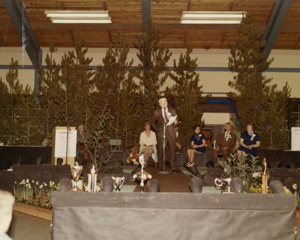
1st Annual Burnaby Rhododendron and Spring Flower Show photographs
https://search.heritageburnaby.ca/link/archivedescription91570
- Repository
- City of Burnaby Archives
- Date
- May 1969
- Collection/Fonds
- Doreen Lawson fonds
- Description Level
- File
- Physical Description
- 13 photographs : col. ; 9 cm x 12.5 cm and smaller
- Scope and Content
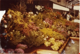
- File consists of photographs of the first annual Burnaby Rhododendron and Spring Flower Show. Photographs depict various exhibitors' displays, including the BC Nursery Trade Society, Planned Parenthood, Board of Parks and Public Recreation (City of Vancouver), and Burnaby Parks and Recreation.
- Repository
- City of Burnaby Archives
- Date
- May 1969
- Collection/Fonds
- Doreen Lawson fonds
- Physical Description
- 13 photographs : col. ; 9 cm x 12.5 cm and smaller
- Description Level
- File
- Record No.
- 605-006
- Access Restriction
- No restrictions
- Reproduction Restriction
- Reproduce for fair dealing purposes only
- Accession Number
- 2003-30
- Scope and Content
- File consists of photographs of the first annual Burnaby Rhododendron and Spring Flower Show. Photographs depict various exhibitors' displays, including the BC Nursery Trade Society, Planned Parenthood, Board of Parks and Public Recreation (City of Vancouver), and Burnaby Parks and Recreation.
- Names
- Lawson, Doreen A.
- Media Type
- Photograph
- Photographer
- Brandson, Lloyd S.
- Knudson, Art
- Notes
- Title based on contents of photographs
- Note in blue ink on verso of photograph 605-006-1 reads: "Burnaby Centennial Committee / 25.00 / Doug Earlaw"
- Note in pencil on verso of photographs 605-006-3 : 605-006-6 reads: "Lloyd. S. Brandson / [address] / [phone]
- Note in blue ink on verso of photograph 605-006-7 reads: ""Golden Sunset" / Art Knudson / [address] / [phone]"
- Note in blue ink on verso of photograph 605-006-13 reads: "Art Knudson / [contact information
Images

1st Burnaby West
https://search.heritageburnaby.ca/link/archivedescription55142
- Repository
- City of Burnaby Archives
- Date
- 1962-1973
- Collection/Fonds
- Burnaby Historical Society fonds
- Description Level
- File
- Physical Description
- 1 scrapbook
- Scope and Content
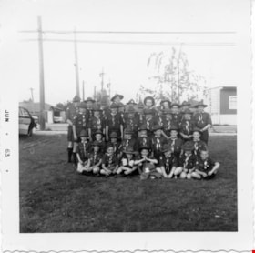
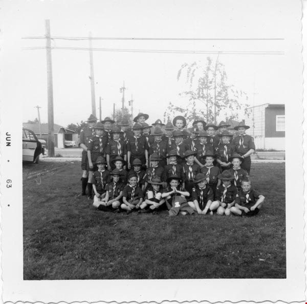
- Scrapbook containing photographs and newspaper clippings pertaining to the 1st Burnaby West Scout troop. Special events and fundraisers depicted in the photographs include: Father and Son banquets, family nights, Going Up ceremonies, colours presentations, bowling and skating events, Model Kub Car…
- Repository
- City of Burnaby Archives
- Date
- 1962-1973
- Collection/Fonds
- Burnaby Historical Society fonds
- Subseries
- Burnaby Scouts subseries
- Physical Description
- 1 scrapbook
- Material Details
- 418 photographs : b&w & col. ; 15 cm x 20 cm and smaller ; newspaper clippings
- Description Level
- File
- Record No.
- 631-043
- Access Restriction
- No restrictions
- Reproduction Restriction
- Reproduce for fair dealing purposes only
- Accession Number
- BHS1994-05
- Scope and Content
- Scrapbook containing photographs and newspaper clippings pertaining to the 1st Burnaby West Scout troop. Special events and fundraisers depicted in the photographs include: Father and Son banquets, family nights, Going Up ceremonies, colours presentations, bowling and skating events, Model Kub Car, Grand Howl, ladies auxiliary among others.
- Names
- Boy Scouts of Canada
- Media Type
- Photograph
- Notes
- Transcribed title
- Title transcribe from first album page
Images

3rd Annual Burnaby Rhododendron and Spring Flower Show photographs
https://search.heritageburnaby.ca/link/archivedescription91569
- Repository
- City of Burnaby Archives
- Date
- May 1969
- Collection/Fonds
- Doreen Lawson fonds
- Description Level
- File
- Physical Description
- 5 photographs : col. ; 9 cm x 11 cm
- Scope and Content
- File consists of photographs of the third annual Burnaby Rhododendron and Spring Flower Show awards ceremony. Photographs depict Burnaby Rhododendron and Spring Flower Show Society President Doreen Lawson, Show Chairman Lloyd Smith, and an unidentified man giving speeches to the crowd of attendees.
- Repository
- City of Burnaby Archives
- Date
- May 1969
- Collection/Fonds
- Doreen Lawson fonds
- Physical Description
- 5 photographs : col. ; 9 cm x 11 cm
- Description Level
- File
- Record No.
- 605-005
- Access Restriction
- No restrictions
- Reproduction Restriction
- Reproduce for fair dealing purposes only
- Accession Number
- 2003-30
- Scope and Content
- File consists of photographs of the third annual Burnaby Rhododendron and Spring Flower Show awards ceremony. Photographs depict Burnaby Rhododendron and Spring Flower Show Society President Doreen Lawson, Show Chairman Lloyd Smith, and an unidentified man giving speeches to the crowd of attendees.
- Names
- Lawson, Doreen A.
- Media Type
- Photograph
- Notes
- Title based on contents of photographs
- Stamp on verso of photographs 605-005-1 and 605-005-5 reads: "Gai paree Supper Club Ltd. / [Contact information]"
Images
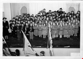
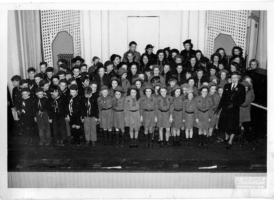
5th Burnaby Brownie concert
https://search.heritageburnaby.ca/link/museumdescription4825
- Repository
- Burnaby Village Museum
- Date
- 1948
- Collection/Fonds
- Burnaby Girl Guides fonds
- Description Level
- Item
- Physical Description
- 1 photograph : b&w ; 12.7 x 17.7 cm
- Scope and Content
- Photograph of 5th Burnaby Brownie Concert with 5th Burnaby Brownies, 5th Burnaby Guides, 1st North Burnaby Cubs and Scouts, Vancouver Sea Rangers, Brown Owl, Mrs. K. Hebron, Area Commissioner Miss R. McArthur, onstage at Gilmore Avenue School Auditorium.
- Repository
- Burnaby Village Museum
- Collection/Fonds
- Burnaby Girl Guides fonds
- Description Level
- Item
- Physical Description
- 1 photograph : b&w ; 12.7 x 17.7 cm
- Scope and Content
- Photograph of 5th Burnaby Brownie Concert with 5th Burnaby Brownies, 5th Burnaby Guides, 1st North Burnaby Cubs and Scouts, Vancouver Sea Rangers, Brown Owl, Mrs. K. Hebron, Area Commissioner Miss R. McArthur, onstage at Gilmore Avenue School Auditorium.
- Subjects
- Performances - Concerts
- Accession Code
- BV015.35.175
- Access Restriction
- No restrictions
- Reproduction Restriction
- No known restrictions
- Date
- 1948
- Media Type
- Photograph
- Scan Resolution
- 600
- Scan Date
- March 8, 2021
- Scale
- 100
- Notes
- Title based on contents of photograph
- This photograph is similar to photograph BV015.35.156.11 but includes people on the left side of the stage.
- Handwritten annotations above photograph reads: "5th Burnaby Brownie Concert with 5th Burnaby Brownies, 5th Burnaby Guides, 1st North Burnaby Cubs and Scouts, Vancouver Sea Rangers, Brown Owl, / Mrs. K. Hebron (below right), Area Commissioner Miss R. McArthur, onstage / at Gilmore Avenue School Auditorium...opening...Feb 25th"
- Photograph is a part of original scrapbook "5th Brownie Pack" 1948-1965 Item BV015.35.156
Images

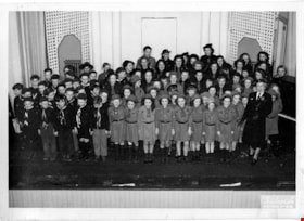
5th Burnaby Brownie concert
https://search.heritageburnaby.ca/link/museumdescription4826
- Repository
- Burnaby Village Museum
- Date
- 1948
- Collection/Fonds
- Burnaby Girl Guides fonds
- Description Level
- Item
- Physical Description
- 1 photograph : b&w ; 12.7 x 17.7 cm
- Scope and Content
- Photograph of 5th Burnaby Brownie Concert with 5th Burnaby Brownies, 5th Burnaby Guides, 1st North Burnaby Cubs and Scouts, Vancouver Sea Rangers, Brown Owl, Mrs. K. Hebron, Area Commissioner Miss R. McArthur, onstage at Gilmore Avenue School Auditorium.
- Repository
- Burnaby Village Museum
- Collection/Fonds
- Burnaby Girl Guides fonds
- Description Level
- Item
- Physical Description
- 1 photograph : b&w ; 12.7 x 17.7 cm
- Scope and Content
- Photograph of 5th Burnaby Brownie Concert with 5th Burnaby Brownies, 5th Burnaby Guides, 1st North Burnaby Cubs and Scouts, Vancouver Sea Rangers, Brown Owl, Mrs. K. Hebron, Area Commissioner Miss R. McArthur, onstage at Gilmore Avenue School Auditorium.
- Accession Code
- BV015.35.176
- Access Restriction
- No restrictions
- Reproduction Restriction
- No known restrictions
- Date
- 1948
- Media Type
- Photograph
- Scan Resolution
- 600
- Scan Date
- March 9, 2021
- Scale
- 100
- Notes
- Title based on contents of photograph
- This photograph is similar to photograph BV015.35.156.10 but includes people on the right side of the stage.
- Handwritten annotations above photograph reads: "5th Burnaby Brownie Concert with 5th Burnaby Brownies, 5th Burnaby Guides, 1st North Burnaby Cubs and Scouts, Vancouver Sea Rangers, Brown Owl, / Mrs. K. Hebron (below right), Area Commissioner Miss R. McArthur, onstage / at Gilmore Avenue School Auditorium...opening...Feb 25th"
- Photograph is a part of original scrapbook "5th Brownie Pack" 1948-1965 Item BV015.35.156
Images