Narrow Results By
Decade
- 2020s 11
- 2010s 4
- 2000s 77
- 1990s 79
- 1980s 20
- 1970s 302
- 1960s 70
- 1950s
- 1940s
- 1930s 51
- 1920s 84
- 1910s 55
- 1900s 18
- 1890s 9
- 1880s 2
- 1870s 1
- 1860s 1
- 1850s 1
- 1840s 1
- 1830s 1
- 1820s 1
- 1810s 1
- 1800s 1
- 1790s 1
- 1780s 1
- 1770s 1
- 1760s 1
- 1750s 1
- 1740s 1
- 1730s 1
- 1720s 1
- 1710s 1
- 1700s 1
- 1690s 1
- 1680s 1
- 1670s 1
- 1660s 1
- 1650s 1
- 1640s 1
- 1630s 1
- 1620s 1
- 1610s 1
- 1600s 1
Subject
- Advertising Medium - Signs and Signboards 1
- Agricultural Tools and Equipment 2
- Agriculture - Farms 15
- Agriculture - Fruit and Berries 1
- Buildings 1
- Buildings - Civic 1
- Buildings - Civic - City Halls 17
- Buildings - Commercial 1
- Buildings - Commercial - Drive-In Theatres 1
- Buildings - Commercial - Grocery Stores 1
- Buildings - Heritage 7
- Buildings - Industrial 1
Douglas Road School
https://search.heritageburnaby.ca/link/archivedescription38640
- Repository
- City of Burnaby Archives
- Date
- 1956
- Collection/Fonds
- Burnaby Historical Society fonds
- Description Level
- Item
- Physical Description
- 1 photograph : b&w ; 8.5 x 12.5 cm
- Scope and Content
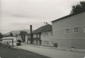
- Photograph of the back of Douglas Road School. Unidentified children are playing near the tire swings and near the school.
- Repository
- City of Burnaby Archives
- Date
- 1956
- Collection/Fonds
- Burnaby Historical Society fonds
- Subseries
- Douglas Road School subseries
- Physical Description
- 1 photograph : b&w ; 8.5 x 12.5 cm
- Description Level
- Item
- Record No.
- 471-001
- Access Restriction
- No restrictions
- Reproduction Restriction
- Reproduce for fair dealing purposes only
- Accession Number
- BHS2005-3
- Scope and Content
- Photograph of the back of Douglas Road School. Unidentified children are playing near the tire swings and near the school.
- Subjects
- Buildings - Schools
- Names
- Douglas Road School
- Media Type
- Photograph
- Photographer
- Gordon, Ethel
- Notes
- Title based on contents of photograph.
- Geographic Access
- Canada Way
- Street Address
- 4861 Canada Way
- Historic Neighbourhood
- Burnaby Lake (Historic Neighbourhood)
- Planning Study Area
- Douglas-Gilpin Area
Images

Douglas Road School
https://search.heritageburnaby.ca/link/archivedescription38642
- Repository
- City of Burnaby Archives
- Date
- 1956
- Collection/Fonds
- Burnaby Historical Society fonds
- Description Level
- Item
- Physical Description
- 1 photograph : b&w ; 10 x 10 cm
- Scope and Content
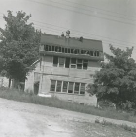
- Photograph of the partially demolished building at the Douglas Road School site.
- Repository
- City of Burnaby Archives
- Date
- 1956
- Collection/Fonds
- Burnaby Historical Society fonds
- Subseries
- Douglas Road School subseries
- Physical Description
- 1 photograph : b&w ; 10 x 10 cm
- Description Level
- Item
- Record No.
- 471-003
- Access Restriction
- No restrictions
- Reproduction Restriction
- Reproduce for fair dealing purposes only
- Accession Number
- BHS2005-3
- Scope and Content
- Photograph of the partially demolished building at the Douglas Road School site.
- Subjects
- Buildings - Schools
- Construction
- Names
- Douglas Road School
- Media Type
- Photograph
- Photographer
- Gordon, Ethel
- Notes
- Title based on contents of photograph.
- Geographic Access
- Canada Way
- Street Address
- 4861 Canada Way
- Historic Neighbourhood
- Burnaby Lake (Historic Neighbourhood)
- Planning Study Area
- Douglas-Gilpin Area
Images

Douglas Road school celebration
https://search.heritageburnaby.ca/link/archivedescription37437
- Repository
- City of Burnaby Archives
- Date
- 1958 (date of original), copied 1991
- Collection/Fonds
- Burnaby Historical Society fonds
- Description Level
- Item
- Physical Description
- 1 photograph : b&w ; 4.1 x 3.3 cm print on contact sheet 20.2 x 25.3 cm
- Scope and Content
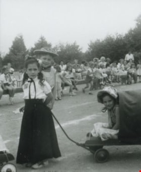
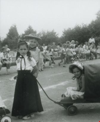
- Photograph of children from Douglas Road School in costume for a centennial or 50th anniversary celebration. Janet Anderson is standing behind the girl in the long black skirt.
- Repository
- City of Burnaby Archives
- Date
- 1958 (date of original), copied 1991
- Collection/Fonds
- Burnaby Historical Society fonds
- Subseries
- Burnaby Image Bank subseries
- Physical Description
- 1 photograph : b&w ; 4.1 x 3.3 cm print on contact sheet 20.2 x 25.3 cm
- Description Level
- Item
- Record No.
- 370-025
- Access Restriction
- No restrictions
- Reproduction Restriction
- No restrictions
- Accession Number
- BHS1999-03
- Scope and Content
- Photograph of children from Douglas Road School in costume for a centennial or 50th anniversary celebration. Janet Anderson is standing behind the girl in the long black skirt.
- Media Type
- Photograph
- Notes
- Title based on contents of photograph
- 1 b&w copy negative accompanying
- Geographic Access
- Canada Way
- Street Address
- 4861 Canada Way
- Historic Neighbourhood
- Burnaby Lake (Historic Neighbourhood)
- Planning Study Area
- Douglas-Gilpin Area
Images
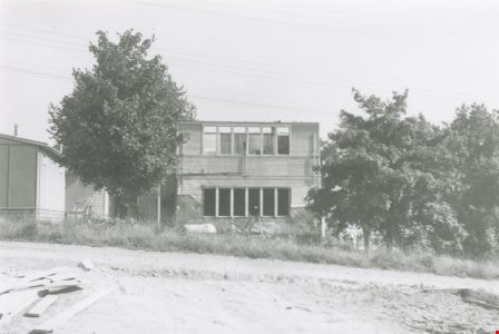
Douglas Road School demolition
https://search.heritageburnaby.ca/link/archivedescription38641
- Repository
- City of Burnaby Archives
- Date
- 1956
- Collection/Fonds
- Burnaby Historical Society fonds
- Description Level
- Item
- Physical Description
- 1 photograph : b&w ; 10 x 15 cm
- Scope and Content
- Photograph of the demolition of the building at the Douglas Road School site.
- Repository
- City of Burnaby Archives
- Date
- 1956
- Collection/Fonds
- Burnaby Historical Society fonds
- Subseries
- Douglas Road School subseries
- Physical Description
- 1 photograph : b&w ; 10 x 15 cm
- Description Level
- Item
- Record No.
- 471-002
- Access Restriction
- No restrictions
- Reproduction Restriction
- Reproduce for fair dealing purposes only
- Accession Number
- BHS2005-3
- Scope and Content
- Photograph of the demolition of the building at the Douglas Road School site.
- Names
- Douglas Road School
- Media Type
- Photograph
- Photographer
- Gordon, Ethel
- Notes
- Title based on contents of photograph
- Geographic Access
- Canada Way
- Street Address
- 4861 Canada Way
- Historic Neighbourhood
- Burnaby Lake (Historic Neighbourhood)
- Planning Study Area
- Douglas-Gilpin Area
Images

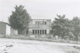
Douglas Road School renovation
https://search.heritageburnaby.ca/link/archivedescription38647
- Repository
- City of Burnaby Archives
- Date
- 1956
- Collection/Fonds
- Burnaby Historical Society fonds
- Description Level
- Item
- Physical Description
- 1 photograph : b&w ; 10 x 15 cm
- Scope and Content
- Photograph of a the Douglas Road school under renovations.
- Repository
- City of Burnaby Archives
- Date
- 1956
- Collection/Fonds
- Burnaby Historical Society fonds
- Subseries
- Douglas Road School subseries
- Physical Description
- 1 photograph : b&w ; 10 x 15 cm
- Description Level
- Item
- Record No.
- 471-008
- Access Restriction
- No restrictions
- Reproduction Restriction
- Reproduce for fair dealing purposes only
- Accession Number
- BHS2005-3
- Scope and Content
- Photograph of a the Douglas Road school under renovations.
- Subjects
- Construction
- Buildings - Schools
- Names
- Douglas Road School
- Media Type
- Photograph
- Photographer
- Gordon, Ethel
- Notes
- Title based on contents of photograph
- Geographic Access
- Canada Way
- Street Address
- 4861 Canada Way
- Historic Neighbourhood
- Burnaby Lake (Historic Neighbourhood)
- Planning Study Area
- Douglas-Gilpin Area
Images

![Douglas Road School students, [between 1940 and 1942] thumbnail](/media/hpo/_Data/_BVM_Images/2017/201700280031_001.jpg?width=280)
Douglas Road School students
https://search.heritageburnaby.ca/link/museumdescription4234
- Repository
- Burnaby Village Museum
- Date
- [between 1940 and 1942]
- Collection/Fonds
- Burnaby Village Museum Photograph collection
- Description Level
- Item
- Physical Description
- 1 photograph : b&w ; 13 x 18 cm
- Scope and Content
- Photograph of students from Douglas Road School, possibly grade seven or eight class. Students and a male teacher are standing and sitting in front of a outside wooden staircase. There are 10 female students and 11 male students. Glen Boal is seated in the front row, third from the right.
- Repository
- Burnaby Village Museum
- Collection/Fonds
- Burnaby Village Museum Photograph collection
- Description Level
- Item
- Physical Description
- 1 photograph : b&w ; 13 x 18 cm
- Material Details
- Handwritten text on back of photograph reads: 'Glen Boal seated front row / 3d from right".
- Scope and Content
- Photograph of students from Douglas Road School, possibly grade seven or eight class. Students and a male teacher are standing and sitting in front of a outside wooden staircase. There are 10 female students and 11 male students. Glen Boal is seated in the front row, third from the right.
- Subjects
- Persons - Students
- Geographic Access
- Canada Way
- Street Address
- 4861 Canada Way
- Accession Code
- BV017.28.31
- Access Restriction
- No restrictions
- Reproduction Restriction
- No known restrictions
- Date
- [between 1940 and 1942]
- Media Type
- Photograph
- Historic Neighbourhood
- Burnaby Lake (Historic Neighbourhood)
- Planning Study Area
- Douglas-Gilpin Area
- Scan Resolution
- 600
- Scan Date
- 06-Mar-2018
- Notes
- Title based on contents of photograph
Images
![Douglas Road School students, [between 1940 and 1942] thumbnail](/media/hpo/_Data/_BVM_Images/2017/201700280031_001.jpg)
![Douglas Road School students, [between 1938 and 1940] thumbnail](/media/hpo/_Data/_BVM_Images/2017/201700280032_001.jpg?width=280)
Douglas Road School students
https://search.heritageburnaby.ca/link/museumdescription4235
- Repository
- Burnaby Village Museum
- Date
- [between 1938 and 1940]
- Collection/Fonds
- Burnaby Village Museum Photograph collection
- Description Level
- Item
- Physical Description
- 1 photograph : b&w ; 13 x 18 cm
- Scope and Content
- Photograph of students from Douglas Road School, elementary grade. This is possibly a combined class as there are two teachers in the photo and 51 students. The students are in four rows with a male teacher at either end of the third row. Glen Boal is at the left end of the third row standing next …
- Repository
- Burnaby Village Museum
- Collection/Fonds
- Burnaby Village Museum Photograph collection
- Description Level
- Item
- Physical Description
- 1 photograph : b&w ; 13 x 18 cm
- Material Details
- Handwritten text on back of photograph reads: 'Glen Boal / 3d Row far left beside teacher".
- Scope and Content
- Photograph of students from Douglas Road School, elementary grade. This is possibly a combined class as there are two teachers in the photo and 51 students. The students are in four rows with a male teacher at either end of the third row. Glen Boal is at the left end of the third row standing next to a teacher.
- Subjects
- Persons - Students
- Geographic Access
- Canada Way
- Street Address
- 4861 Canada Way
- Accession Code
- BV017.28.32
- Access Restriction
- No restrictions
- Reproduction Restriction
- No known restrictions
- Date
- [between 1938 and 1940]
- Media Type
- Photograph
- Historic Neighbourhood
- Burnaby Lake (Historic Neighbourhood)
- Planning Study Area
- Douglas-Gilpin Area
- Scan Resolution
- 600
- Scan Date
- 06-Mar-2018
- Notes
- Title based on contents of photograph
Images
![Douglas Road School students, [between 1938 and 1940] thumbnail](/media/hpo/_Data/_BVM_Images/2017/201700280032_001.jpg)

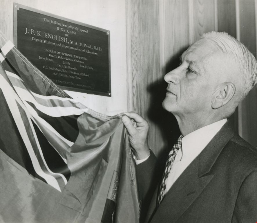
Dr. J. F. K. English
https://search.heritageburnaby.ca/link/archivedescription45218
- Repository
- City of Burnaby Archives
- Date
- June 3, 1959, published June 21, 1959
- Collection/Fonds
- Columbian Newspaper collection
- Description Level
- Item
- Physical Description
- 1 photograph : b&w ; 12 x 14 cm
- Scope and Content
- Photograph of Dr. J.F.K. English, then Deputy Minister and Superintendent of Education, unveiling the plaque that marked the official opening of Burnaby's school board offices at 5325 Kincaid.
- Repository
- City of Burnaby Archives
- Date
- June 3, 1959, published June 21, 1959
- Collection/Fonds
- Columbian Newspaper collection
- Physical Description
- 1 photograph : b&w ; 12 x 14 cm
- Description Level
- Item
- Record No.
- 480-114
- Access Restriction
- No restrictions
- Reproduction Restriction
- No restrictions
- Accession Number
- 2003-02
- Scope and Content
- Photograph of Dr. J.F.K. English, then Deputy Minister and Superintendent of Education, unveiling the plaque that marked the official opening of Burnaby's school board offices at 5325 Kincaid.
- Subjects
- Ceremonies
- Media Type
- Photograph
- Photographer
- King, Basil
- Notes
- Title based on contents of photograph
- Geographic Access
- Kincaid Street
- Street Address
- 5325 Kincaid Street
- Historic Neighbourhood
- Burnaby Lake (Historic Neighbourhood)
- Planning Study Area
- Douglas-Gilpin Area
Images
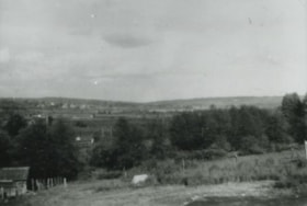
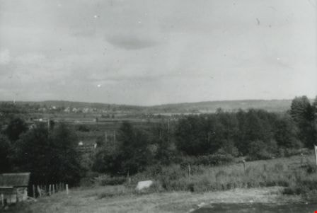
East from Norland Avenue
https://search.heritageburnaby.ca/link/archivedescription37433
- Repository
- City of Burnaby Archives
- Date
- 1949 (date of original), copied 1991
- Collection/Fonds
- Burnaby Historical Society fonds
- Description Level
- Item
- Physical Description
- 1 photograph : b&w ; 2.2 x 4.0 cm print on contact sheet 20.2 x 25.3 cm
- Scope and Content
- Photograph from the back of 4437 Norland Avenue (later renumber 3908 Norland Avenue), facing east. This photograph was taken before the Trans Canada Highway was built.
- Repository
- City of Burnaby Archives
- Date
- 1949 (date of original), copied 1991
- Collection/Fonds
- Burnaby Historical Society fonds
- Subseries
- Burnaby Image Bank subseries
- Physical Description
- 1 photograph : b&w ; 2.2 x 4.0 cm print on contact sheet 20.2 x 25.3 cm
- Description Level
- Item
- Record No.
- 370-021
- Access Restriction
- No restrictions
- Reproduction Restriction
- No restrictions
- Accession Number
- BHS1999-03
- Scope and Content
- Photograph from the back of 4437 Norland Avenue (later renumber 3908 Norland Avenue), facing east. This photograph was taken before the Trans Canada Highway was built.
- Media Type
- Photograph
- Notes
- Title based on contents of photograph
- 1 b&w copy negative accompanying
- Geographic Access
- Norland Avenue
- Street Address
- 3908 Norland Avenue
- Historic Neighbourhood
- Burnaby Lake (Historic Neighbourhood)
- Planning Study Area
- Douglas-Gilpin Area
Images
![Fairacres front walk, [between 1939 and 1954] thumbnail](/media/hpo/_Data/_Archives_Images/_Unrestricted/205/242-003.jpg?width=280)
Fairacres front walk
https://search.heritageburnaby.ca/link/archivedescription36253
- Repository
- City of Burnaby Archives
- Date
- [between 1939 and 1954]
- Collection/Fonds
- Burnaby Historical Society fonds
- Description Level
- Item
- Physical Description
- 1 photograph : b&w copy negative ; 3.5 x 5 cm
- Scope and Content
- Photograph of the front walk at the Ceperley Mansion, (Fairacres). The Order of St. Benedict purchased and occupied it from 1939 to 1954. The roadway is paved and the walkway is made of paving stones.
- Repository
- City of Burnaby Archives
- Date
- [between 1939 and 1954]
- Collection/Fonds
- Burnaby Historical Society fonds
- Subseries
- Burnaby Art Gallery subseries
- Physical Description
- 1 photograph : b&w copy negative ; 3.5 x 5 cm
- Description Level
- Item
- Record No.
- 242-003
- Access Restriction
- No restrictions
- Reproduction Restriction
- No known restrictions
- Accession Number
- BHS1990-05
- Scope and Content
- Photograph of the front walk at the Ceperley Mansion, (Fairacres). The Order of St. Benedict purchased and occupied it from 1939 to 1954. The roadway is paved and the walkway is made of paving stones.
- Media Type
- Photograph
- Notes
- Title based on contents of photograph
- Geographic Access
- Deer Lake Avenue
- Street Address
- 6344 Deer Lake Avenue
- Historic Neighbourhood
- Burnaby Lake (Historic Neighbourhood)
- Planning Study Area
- Douglas-Gilpin Area
Images
![Fairacres front walk, [between 1939 and 1954] thumbnail](/media/hpo/_Data/_Archives_Images/_Unrestricted/205/242-003.jpg)
Fairacres Mansion
https://search.heritageburnaby.ca/link/archivedescription51376
- Repository
- City of Burnaby Archives
- Date
- [after 1911]
- Collection/Fonds
- Burnaby Historical Society fonds
- Description Level
- Item
- Physical Description
- 1 photograph : b&w copy negative ; 6.5 x 10 cm
- Scope and Content
- Photograph of the back of the Fairacres Mansion. A large tree dominates the right side of the image.
- Repository
- City of Burnaby Archives
- Date
- [after 1911]
- Collection/Fonds
- Burnaby Historical Society fonds
- Subseries
- Burnaby Art Gallery subseries
- Physical Description
- 1 photograph : b&w copy negative ; 6.5 x 10 cm
- Description Level
- Item
- Record No.
- 242-031
- Access Restriction
- No restrictions
- Reproduction Restriction
- No known restrictions
- Accession Number
- BHS1990-05
- Scope and Content
- Photograph of the back of the Fairacres Mansion. A large tree dominates the right side of the image.
- Subjects
- Buildings - Residential - Houses
- Media Type
- Photograph
- Notes
- Title based on contents of photograph
- Geographic Access
- Deer Lake Avenue
- Street Address
- 6344 Deer Lake Avenue
- Historic Neighbourhood
- Burnaby Lake (Historic Neighbourhood)
- Planning Study Area
- Douglas-Gilpin Area
![Father Joseph of the Benedictines, [between 1950 and 1954] thumbnail](/media/hpo/_Data/_Archives_Images/_Unrestricted/205/242-002.jpg?width=280)
Father Joseph of the Benedictines
https://search.heritageburnaby.ca/link/archivedescription36252
- Repository
- City of Burnaby Archives
- Date
- [between 1950 and 1954]
- Collection/Fonds
- Burnaby Historical Society fonds
- Description Level
- Item
- Physical Description
- 1 photograph : b&w copy negative ; 3.5 x 5 cm
- Scope and Content
- Photograph of "Father Joseph" one of the monks of the Order of St. Benedict. He is riding a tractor on the front lawn of Fairacres. The Benedictines purchased and occupied Fairacres from 1939 to 1954.
- Repository
- City of Burnaby Archives
- Date
- [between 1950 and 1954]
- Collection/Fonds
- Burnaby Historical Society fonds
- Subseries
- Burnaby Art Gallery subseries
- Physical Description
- 1 photograph : b&w copy negative ; 3.5 x 5 cm
- Description Level
- Item
- Record No.
- 242-002
- Access Restriction
- No restrictions
- Reproduction Restriction
- Reproduce for fair dealing purposes only
- Accession Number
- BHS1990-05
- Scope and Content
- Photograph of "Father Joseph" one of the monks of the Order of St. Benedict. He is riding a tractor on the front lawn of Fairacres. The Benedictines purchased and occupied Fairacres from 1939 to 1954.
- Media Type
- Photograph
- Notes
- Title based on contents of photograph 1 b&w copy print accompanying
- Geographic Access
- Deer Lake Avenue
- Street Address
- 6344 Deer Lake Avenue
- Historic Neighbourhood
- Burnaby Lake (Historic Neighbourhood)
- Planning Study Area
- Douglas-Gilpin Area
Images
![Father Joseph of the Benedictines, [between 1950 and 1954] thumbnail](/media/hpo/_Data/_Archives_Images/_Unrestricted/205/242-002.jpg)
![Fertilizing the yard, [1959] (date of original), digitally copied 2012 thumbnail](/media/hpo/_Data/_Archives_Images/_Unrestricted/540/549-032.jpg?width=280)
Fertilizing the yard
https://search.heritageburnaby.ca/link/archivedescription76912
- Repository
- City of Burnaby Archives
- Date
- [1959] (date of original), digitally copied 2012
- Collection/Fonds
- Community Heritage Commission Special Projects fonds
- Description Level
- Item
- Physical Description
- 1 photograph (jpeg) : col. ; 300ppi
- Scope and Content
- Photograph of a man using a team of horses to help him lay fertilizer on the yard at Tony Fabian's house on Hardwick Street.
- Repository
- City of Burnaby Archives
- Date
- [1959] (date of original), digitally copied 2012
- Collection/Fonds
- Community Heritage Commission Special Projects fonds
- Physical Description
- 1 photograph (jpeg) : col. ; 300ppi
- Description Level
- Item
- Record No.
- 549-032
- Access Restriction
- No restrictions
- Reproduction Restriction
- Reproduce for fair dealing purposes only
- Accession Number
- 2012-30
- Scope and Content
- Photograph of a man using a team of horses to help him lay fertilizer on the yard at Tony Fabian's house on Hardwick Street.
- Media Type
- Photograph
- Notes
- Title based on contents of photograph
- Geographic Access
- Hardwick Street
- Planning Study Area
- Douglas-Gilpin Area
Images
![Fertilizing the yard, [1959] (date of original), digitally copied 2012 thumbnail](/media/hpo/_Data/_Archives_Images/_Unrestricted/540/549-032.jpg)
![Flooded Chan family farm, [1948] thumbnail](/media/hpo/_Data/_BVM_Images/2017/2017_0024_0023_001.jpg?width=280)
Flooded Chan family farm
https://search.heritageburnaby.ca/link/museumdescription4069
- Repository
- Burnaby Village Museum
- Date
- [1948]
- Collection/Fonds
- Julie Lee and Cecil Lee family fonds
- Description Level
- Item
- Physical Description
- 1 photograph (tiff) : sepia ; 1000 dpi
- Scope and Content
- Photograph of Suey Ying Jung (Laura) and Puy Yuen Chan in a canoe on the flooded family farm; background contains trees and two buildings; foreground contains a hedge.
- Repository
- Burnaby Village Museum
- Collection/Fonds
- Julie Lee and Cecil Lee family fonds
- Description Level
- Item
- Physical Description
- 1 photograph (tiff) : sepia ; 1000 dpi
- Scope and Content
- Photograph of Suey Ying Jung (Laura) and Puy Yuen Chan in a canoe on the flooded family farm; background contains trees and two buildings; foreground contains a hedge.
- Accession Code
- BV017.24.23
- Access Restriction
- No restrictions
- Reproduction Restriction
- No known restrictions
- Date
- [1948]
- Media Type
- Photograph
- Historic Neighbourhood
- Burnaby Lake (Historic Neighbourhood)
- Planning Study Area
- Douglas-Gilpin Area
- Scan Resolution
- 1000
- Scan Date
- 01-Oct-2017
- Scale
- 100
- Notes
- Title based on contents of photograph
Images
![Flooded Chan family farm, [1948] thumbnail](/media/hpo/_Data/_BVM_Images/2017/2017_0024_0023_001.jpg)
![Flooded Chan family farm, [1948] thumbnail](/media/hpo/_Data/_BVM_Images/2017/201700240024_001.jpg?width=280)
Flooded Chan family farm
https://search.heritageburnaby.ca/link/museumdescription4070
- Repository
- Burnaby Village Museum
- Date
- [1948]
- Collection/Fonds
- Julie Lee and Cecil Lee family fonds
- Description Level
- Item
- Physical Description
- 1 photograph (tiff) : sepia ; 1000 dpi
- Scope and Content
- Photograph of the flooded Chan family farm; buildings and telephone poles throughout the landscape.
- Repository
- Burnaby Village Museum
- Collection/Fonds
- Julie Lee and Cecil Lee family fonds
- Description Level
- Item
- Physical Description
- 1 photograph (tiff) : sepia ; 1000 dpi
- Scope and Content
- Photograph of the flooded Chan family farm; buildings and telephone poles throughout the landscape.
- Accession Code
- BV017.24.24
- Access Restriction
- No restrictions
- Reproduction Restriction
- No known restrictions
- Date
- [1948]
- Media Type
- Photograph
- Historic Neighbourhood
- Burnaby Lake (Historic Neighbourhood)
- Planning Study Area
- Douglas-Gilpin Area
- Scan Resolution
- 1000
- Scan Date
- 01-Oct-2017
- Scale
- 100
- Notes
- Title based on contents of photograph
Images
![Flooded Chan family farm, [1948] thumbnail](/media/hpo/_Data/_BVM_Images/2017/201700240024_001.jpg)
![Forest Lawn Cemetery, [1958] thumbnail](/media/hpo/_Data/_Archives_Images/_Unrestricted/001/067-001.jpg?width=280)
Forest Lawn Cemetery
https://search.heritageburnaby.ca/link/archivedescription34631
- Repository
- City of Burnaby Archives
- Date
- [1958]
- Collection/Fonds
- Burnaby Historical Society fonds
- Description Level
- Item
- Physical Description
- 1 photograph : b&w ; 20.2 x 25.2 cm
- Scope and Content
- Photograph of Forest Lawn Cemetery at Canada Way and Royal Oak Avenue showing buildings and lawns.
- Repository
- City of Burnaby Archives
- Date
- [1958]
- Collection/Fonds
- Burnaby Historical Society fonds
- Subseries
- Photographs subseries
- Physical Description
- 1 photograph : b&w ; 20.2 x 25.2 cm
- Description Level
- Item
- Record No.
- 067-001
- Access Restriction
- No restrictions
- Reproduction Restriction
- Reproduce for fair dealing purposes only
- Accession Number
- BHS2007-04
- Scope and Content
- Photograph of Forest Lawn Cemetery at Canada Way and Royal Oak Avenue showing buildings and lawns.
- Subjects
- Cemeteries
- Media Type
- Photograph
- Notes
- Title based on contents of photograph
- Geographic Access
- Royal Oak Avenue
- Street Address
- 3789 Royal Oak Avenue
- Historic Neighbourhood
- Burnaby Lake (Historic Neighbourhood)
- Planning Study Area
- Douglas-Gilpin Area
Images
![Forest Lawn Cemetery, [1958] thumbnail](/media/hpo/_Data/_Archives_Images/_Unrestricted/001/067-001.jpg)
![Gordon and Harry Jung with Philip Mah, [between 1935 and 1945] thumbnail](/media/hpo/_Data/_BVM_Images/2021/2021_0019_0003_001.jpg?width=280)
Gordon and Harry Jung with Philip Mah
https://search.heritageburnaby.ca/link/museumdescription16728
- Repository
- Burnaby Village Museum
- Date
- [between 1935 and 1945]
- Collection/Fonds
- Julie Lee and Cecil Lee family fonds
- Description Level
- Item
- Physical Description
- 1 photograph (jpg)
- Scope and Content
- Photograph of Suey Yook "Gordon" Jung and Suey Cheung "Harry" Jung standing with young, Philip Mah on the boardwalk outside the Jung family home located on the family farm at 5460 Douglas Road (address was changed to 5286 Douglas Road in 1958) in Burnaby. Philip Mah is the son of Lil Mah.
- Repository
- Burnaby Village Museum
- Collection/Fonds
- Julie Lee and Cecil Lee family fonds
- Description Level
- Item
- Physical Description
- 1 photograph (jpg)
- Scope and Content
- Photograph of Suey Yook "Gordon" Jung and Suey Cheung "Harry" Jung standing with young, Philip Mah on the boardwalk outside the Jung family home located on the family farm at 5460 Douglas Road (address was changed to 5286 Douglas Road in 1958) in Burnaby. Philip Mah is the son of Lil Mah.
- Geographic Access
- Vancouver
- Street Address
- 5286 Douglas Road
- Accession Code
- BV021.19.3
- Access Restriction
- No restrictions
- Reproduction Restriction
- No known restrictions
- Date
- [between 1935 and 1945]
- Media Type
- Photograph
- Historic Neighbourhood
- Burnaby Lake (Historic Neighbourhood)
- Planning Study Area
- Douglas-Gilpin Area
- Scan Resolution
- 96
- Scan Date
- April 13, 2021
- Scale
- 100
- Notes
- Title based on contents of photograph
Images
![Gordon and Harry Jung with Philip Mah, [between 1935 and 1945] thumbnail](/media/hpo/_Data/_BVM_Images/2021/2021_0019_0003_001.jpg)
![Gordon Jung and Gee Shee Jung, [between 1935 and 1945] thumbnail](/media/hpo/_Data/_BVM_Images/2021/2021_0019_0001_001.jpg?width=280)
Gordon Jung and Gee Shee Jung
https://search.heritageburnaby.ca/link/museumdescription16726
- Repository
- Burnaby Village Museum
- Date
- [between 1935 and 1945]
- Collection/Fonds
- Julie Lee and Cecil Lee family fonds
- Description Level
- Item
- Physical Description
- 1 photograph (jpg)
- Scope and Content
- Photograph of Suey Yook "Gordon" Jung standing with his mother, Gee Shee Jung on the family farm located at 5460 Douglas Road in Burnaby (address was changed to 5286 Douglas Road in 1958).
- Repository
- Burnaby Village Museum
- Collection/Fonds
- Julie Lee and Cecil Lee family fonds
- Description Level
- Item
- Physical Description
- 1 photograph (jpg)
- Scope and Content
- Photograph of Suey Yook "Gordon" Jung standing with his mother, Gee Shee Jung on the family farm located at 5460 Douglas Road in Burnaby (address was changed to 5286 Douglas Road in 1958).
- Geographic Access
- Vancouver
- Street Address
- 5286 Douglas Road
- Accession Code
- BV021.19.1
- Access Restriction
- No restrictions
- Reproduction Restriction
- No known restrictions
- Date
- [between 1935 and 1945]
- Media Type
- Photograph
- Historic Neighbourhood
- Burnaby Lake (Historic Neighbourhood)
- Planning Study Area
- Douglas-Gilpin Area
- Scan Resolution
- 96
- Scan Date
- April 13, 2021
- Scale
- 100
- Notes
- Title based on contents of photograph
Images
![Gordon Jung and Gee Shee Jung, [between 1935 and 1945] thumbnail](/media/hpo/_Data/_BVM_Images/2021/2021_0019_0001_001.jpg)
![Gordon Jung and Herbert Yep, [between 1935 and 1945] thumbnail](/media/hpo/_Data/_BVM_Images/2021/2021_0019_0004_001.jpg?width=280)
Gordon Jung and Herbert Yep
https://search.heritageburnaby.ca/link/museumdescription16730
- Repository
- Burnaby Village Museum
- Date
- [between 1935 and 1945]
- Collection/Fonds
- Julie Lee and Cecil Lee family fonds
- Description Level
- Item
- Physical Description
- 1 photograph (jpg)
- Scope and Content
- Photograph of Suey Yook "Gordon" Jung and Herbert Yep standing together on the boardwalk outside the Jung family home located on the family farm at 5460 Douglas Road (address was changed to 5286 Douglas Road in 1958) in Burnaby.
- Repository
- Burnaby Village Museum
- Collection/Fonds
- Julie Lee and Cecil Lee family fonds
- Description Level
- Item
- Physical Description
- 1 photograph (jpg)
- Scope and Content
- Photograph of Suey Yook "Gordon" Jung and Herbert Yep standing together on the boardwalk outside the Jung family home located on the family farm at 5460 Douglas Road (address was changed to 5286 Douglas Road in 1958) in Burnaby.
- Geographic Access
- Vancouver
- Street Address
- 5286 Douglas Road
- Accession Code
- BV021.19.4
- Access Restriction
- No restrictions
- Reproduction Restriction
- No known restrictions
- Date
- [between 1935 and 1945]
- Media Type
- Photograph
- Historic Neighbourhood
- Burnaby Lake (Historic Neighbourhood)
- Planning Study Area
- Douglas-Gilpin Area
- Scan Resolution
- 96
- Scan Date
- April 13, 2021
- Scale
- 100
- Notes
- Title based on contents of photograph
Images
![Gordon Jung and Herbert Yep, [between 1935 and 1945] thumbnail](/media/hpo/_Data/_BVM_Images/2021/2021_0019_0004_001.jpg)
![Gordon Jung on family farm, [between 1935 and 1945] thumbnail](/media/hpo/_Data/_BVM_Images/2021/2021_0019_0002_001.jpg?width=280)
Gordon Jung on family farm
https://search.heritageburnaby.ca/link/museumdescription16727
- Repository
- Burnaby Village Museum
- Date
- [between 1935 and 1945]
- Collection/Fonds
- Julie Lee and Cecil Lee family fonds
- Description Level
- Item
- Physical Description
- 1 photograph (jpg)
- Scope and Content
- Photograph of Gordon Jung leaning against a tree on the family farm located at 5460 Douglas Road in Burnaby (address was changed to 5286 Douglas Road in 1958). Buildings along Douglas Road are visible in the background.
- Repository
- Burnaby Village Museum
- Collection/Fonds
- Julie Lee and Cecil Lee family fonds
- Description Level
- Item
- Physical Description
- 1 photograph (jpg)
- Scope and Content
- Photograph of Gordon Jung leaning against a tree on the family farm located at 5460 Douglas Road in Burnaby (address was changed to 5286 Douglas Road in 1958). Buildings along Douglas Road are visible in the background.
- Names
- Jung, Suey Yook "Gordon"
- Geographic Access
- Vancouver
- Street Address
- 5286 Douglas Road
- Accession Code
- BV021.19.2
- Access Restriction
- No restrictions
- Reproduction Restriction
- No known restrictions
- Date
- [between 1935 and 1945]
- Media Type
- Photograph
- Historic Neighbourhood
- Burnaby Lake (Historic Neighbourhood)
- Planning Study Area
- Douglas-Gilpin Area
- Scan Resolution
- 96
- Scan Date
- April 13, 2021
- Scale
- 100
- Notes
- Title based on contents of photograph
Images
![Gordon Jung on family farm, [between 1935 and 1945] thumbnail](/media/hpo/_Data/_BVM_Images/2021/2021_0019_0002_001.jpg)