Narrow Results By
Subject
- Advertising Medium - Signs and Signboards 1
- Animals - Birds 2
- Animals - Cows 1
- Buildings - Agricultural - Greenhouses 1
- Buildings - Civic - Hospitals 2
- Buildings - Commercial 2
- Buildings - Heritage 58
- Buildings - Residential 1
- Buildings - Residential - Apartments 2
- Buildings - Residential - Houses 2
- Buildings - Residential - Seniors Housing 1
- Buildings - Schools 1
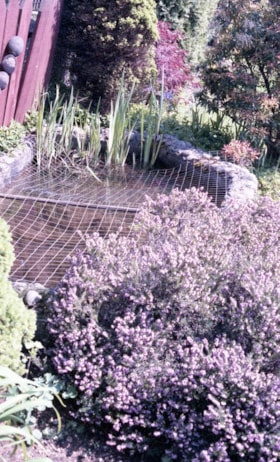
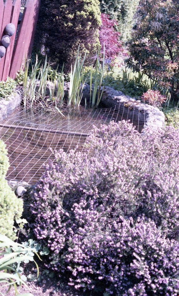
North elevation of fish pond
https://search.heritageburnaby.ca/link/museumdescription10699
- Repository
- Burnaby Village Museum
- Date
- May 4, 1988
- Collection/Fonds
- Burnaby Village Museum fonds
- Description Level
- Item
- Physical Description
- 1 photograph : col. negative ; 35 mm
- Scope and Content
- Photograph of the north elevation of the fish pond at Love farmhouse located at 7651 Cumberland Street (the corner of 14th Avenue and Cumberland Street).The photograph was taken of the house once it was saved and acquired by the Burnaby Village Museum.
- Repository
- Burnaby Village Museum
- Collection/Fonds
- Burnaby Village Museum fonds
- Series
- Jesse Love farmhouse series
- Description Level
- Item
- Physical Description
- 1 photograph : col. negative ; 35 mm
- Material Details
- Photograph is part of Film roll "A"- 15 colour prints that are a part of a collection described as BV018.41.82
- Scope and Content
- Photograph of the north elevation of the fish pond at Love farmhouse located at 7651 Cumberland Street (the corner of 14th Avenue and Cumberland Street).The photograph was taken of the house once it was saved and acquired by the Burnaby Village Museum.
- Subjects
- Buildings - Heritage
- Geographic Access
- Cumberland Street
- Street Address
- 7651 Cumberland Street
- Accession Code
- BV018.41.222
- Access Restriction
- No restrictions
- Reproduction Restriction
- No known restrictions
- Date
- May 4, 1988
- Media Type
- Photograph
- Historic Neighbourhood
- East Burnaby (Historic Neighbourhood)
- Planning Study Area
- Cariboo-Armstrong Area
- Related Material
- See BV018.41.82 for File Level Description
- Scan Resolution
- 2400
- Scan Date
- 5/19/2019
- Scale
- 100
- Photographer
- Wolf, Jim
- Notes
- Title based on contents of photograph
- Photograph is a part of file level description "Photographic documentation of changes and move" BV018.41.82
Images
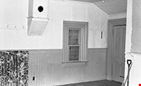
North elevation of kitchen
https://search.heritageburnaby.ca/link/museumdescription10803
- Repository
- Burnaby Village Museum
- Date
- April 8, 1988
- Collection/Fonds
- Burnaby Village Museum fonds
- Description Level
- Item
- Physical Description
- 1 photograph : col. negative ; 35 mm
- Scope and Content
- Photograph of the north elevation of the kitchen of the Love farmhouse while it was located at 7651 Cumberland Street (the corner of 14th Avenue and Cumberland Street). The photograph was taken of the house once it was saved and acquired by the Burnaby Village Museum.
- Repository
- Burnaby Village Museum
- Collection/Fonds
- Burnaby Village Museum fonds
- Series
- Jesse Love farmhouse series
- Description Level
- Item
- Physical Description
- 1 photograph : col. negative ; 35 mm
- Material Details
- Photograph is part of Film roll "F" - 23 colour photographs that are a part of a collection described as BV018.41.82
- Scope and Content
- Photograph of the north elevation of the kitchen of the Love farmhouse while it was located at 7651 Cumberland Street (the corner of 14th Avenue and Cumberland Street). The photograph was taken of the house once it was saved and acquired by the Burnaby Village Museum.
- Subjects
- Buildings - Heritage
- Geographic Access
- Cumberland Street
- Street Address
- 7651 Cumberland Street
- Accession Code
- BV018.41.325
- Access Restriction
- No restrictions
- Reproduction Restriction
- No known restrictions
- Date
- April 8, 1988
- Media Type
- Photograph
- Historic Neighbourhood
- East Burnaby (Historic Neighbourhood)
- Planning Study Area
- Cariboo-Armstrong Area
- Related Material
- See BV018.41.82 for File Level Description
- Scan Resolution
- 2400
- Scan Date
- 13-May-19
- Scale
- 100
- Photographer
- Wolf, Jim
- Notes
- Title based on contents of photograph
- Photograph is a part of file level description "Photographic documentation of changes and move" BV018.41.82
Images

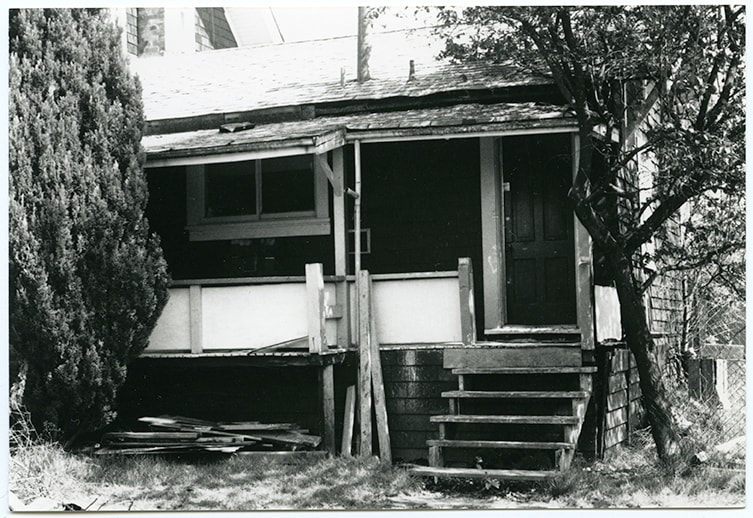
North side exterior of kitchen and porch
https://search.heritageburnaby.ca/link/museumdescription10704
- Repository
- Burnaby Village Museum
- Date
- May 4, 1988
- Collection/Fonds
- Burnaby Village Museum fonds
- Description Level
- Item
- Physical Description
- 1 photograph : b&w ; 13 x 9 cm
- Scope and Content
- Photograph of the north side exterior of the Jesse Love farmhouse with the kitchen and porch. The farmhouse is located at 7651 Cumberland Street (the corner of 14th Avenue and Cumberland Street) in Burnaby.
- Repository
- Burnaby Village Museum
- Collection/Fonds
- Burnaby Village Museum fonds
- Series
- Jesse Love farmhouse series
- Description Level
- Item
- Physical Description
- 1 photograph : b&w ; 13 x 9 cm
- Material Details
- Photograph is part of Film roll "B" - 24 b&w photographs that are a part of a collection described as BV018.41.82
- Scope and Content
- Photograph of the north side exterior of the Jesse Love farmhouse with the kitchen and porch. The farmhouse is located at 7651 Cumberland Street (the corner of 14th Avenue and Cumberland Street) in Burnaby.
- Subjects
- Buildings - Heritage
- Geographic Access
- Cumberland Street
- Street Address
- 7651 Cumberland Street
- Accession Code
- BV018.41.227
- Access Restriction
- No restrictions
- Reproduction Restriction
- No known restrictions
- Date
- May 4, 1988
- Media Type
- Photograph
- Historic Neighbourhood
- East Burnaby (Historic Neighbourhood)
- Planning Study Area
- Cariboo-Armstrong Area
- Related Material
- See BV018.41.82 for File Level Description
- Scan Resolution
- 600
- Scan Date
- 27-May-19
- Scale
- 100
- Photographer
- Wolf, Jim
- Notes
- Title based on contents of photograph
- Photograph is a part of file level description "Photographic documentation of changes and move" BV018.41.82
Images
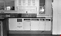
North side of kitchen
https://search.heritageburnaby.ca/link/museumdescription10751
- Repository
- Burnaby Village Museum
- Date
- May 6, 1988
- Collection/Fonds
- Burnaby Village Museum fonds
- Description Level
- Item
- Physical Description
- 1 photograph : b&w negative ; 35 mm
- Scope and Content
- Photograph of the north side of the Love farmhouse kitchen with cupboards and shelving. The house is located at 7651 Cumberland Street (the corner of 14th Avenue and Cumberland Street).
- Repository
- Burnaby Village Museum
- Collection/Fonds
- Burnaby Village Museum fonds
- Series
- Jesse Love farmhouse series
- Description Level
- Item
- Physical Description
- 1 photograph : b&w negative ; 35 mm
- Material Details
- Photograph is part of Film roll "C" - 36 b&w photographs that are a part of a collection described as BV018.41.83
- Scope and Content
- Photograph of the north side of the Love farmhouse kitchen with cupboards and shelving. The house is located at 7651 Cumberland Street (the corner of 14th Avenue and Cumberland Street).
- Subjects
- Buildings - Heritage
- Geographic Access
- Cumberland Street
- Street Address
- 7651 Cumberland Street
- Accession Code
- BV018.41.274
- Access Restriction
- No restrictions
- Reproduction Restriction
- No known restrictions
- Date
- May 6, 1988
- Media Type
- Photograph
- Historic Neighbourhood
- East Burnaby (Historic Neighbourhood)
- Planning Study Area
- Cariboo-Armstrong Area
- Related Material
- See BV018.41.82 for File Level Description
- Scan Resolution
- 2400
- Scan Date
- 5/19/2019
- Scale
- 100
- Photographer
- Wolf, Jim
- Notes
- Title based on contents of photograph
- Photograph is a part of file level description "Photographic documentation of changes and move" BV018.41.82
Images


Northwest corner of kitchen
https://search.heritageburnaby.ca/link/museumdescription10874
- Repository
- Burnaby Village Museum
- Date
- April 11, 1988
- Collection/Fonds
- Burnaby Village Museum fonds
- Description Level
- Item
- Physical Description
- 1 photograph : b&w negative ; 35 mm
- Scope and Content
- Photograph of the northwest corner of the kitchen inside the Love farmhouse. The house is located at 7651 Cumberland Street (the corner of 14th Avenue and Cumberland Street). The photograph was taken of the house once it was saved and acquired by the Burnaby Village Museum.
- Repository
- Burnaby Village Museum
- Collection/Fonds
- Burnaby Village Museum fonds
- Series
- Jesse Love farmhouse series
- Description Level
- Item
- Physical Description
- 1 photograph : b&w negative ; 35 mm
- Material Details
- Photograph is part of Film roll "H" - 36 b&w photographs that are a part of a collection described as BV018.41.82
- Scope and Content
- Photograph of the northwest corner of the kitchen inside the Love farmhouse. The house is located at 7651 Cumberland Street (the corner of 14th Avenue and Cumberland Street). The photograph was taken of the house once it was saved and acquired by the Burnaby Village Museum.
- Subjects
- Buildings - Heritage
- Geographic Access
- Cumberland Street
- Street Address
- 7651 Cumberland Street
- Accession Code
- BV018.41.396
- Access Restriction
- No restrictions
- Reproduction Restriction
- No known restrictions
- Date
- April 11, 1988
- Media Type
- Photograph
- Historic Neighbourhood
- East Burnaby (Historic Neighbourhood)
- Planning Study Area
- Cariboo-Armstrong Area
- Related Material
- See BV018.41.82 for File Level Description
- Scan Resolution
- 2400
- Scan Date
- 6/3/2019
- Scale
- 100
- Photographer
- Wolf, Jim
- Notes
- Title based on contents of photograph
- Photograph is a part of file level description "Photographic documentation of changes and move" BV018.41.82
Images
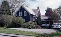
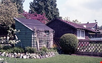
Northwest elevation of Love farmhouse
https://search.heritageburnaby.ca/link/museumdescription2164
- Repository
- Burnaby Village Museum
- Date
- 04-May-88
- Collection/Fonds
- Burnaby Village Museum fonds
- Description Level
- Item
- Physical Description
- 1 photograph : col. negative ; 35 mm
- Scope and Content
- Photograph of the northwest elevation of the Love farmhouse located at 7651 Cumberland Street (the corner of 14th Avenue and Cumberland Street).The photograph was taken of the house once it was saved and acquired by the Burnaby Village Museum. Kitchen and driveway are visible.
- Repository
- Burnaby Village Museum
- Collection/Fonds
- Burnaby Village Museum fonds
- Series
- Jesse Love farmhouse series
- Description Level
- Item
- Physical Description
- 1 photograph : col. negative ; 35 mm
- Material Details
- Photograph is part of Film roll "A"- 15 colour prints that are a part of a collection described as BV018.41.82
- Scope and Content
- Photograph of the northwest elevation of the Love farmhouse located at 7651 Cumberland Street (the corner of 14th Avenue and Cumberland Street).The photograph was taken of the house once it was saved and acquired by the Burnaby Village Museum. Kitchen and driveway are visible.
- Subjects
- Buildings - Heritage
- Geographic Access
- Cumberland Street
- Street Address
- 7651 Cumberland Street
- Accession Code
- BV018.41.212
- Access Restriction
- No restrictions
- Reproduction Restriction
- No known restrictions
- Date
- 04-May-88
- Media Type
- Photograph
- Historic Neighbourhood
- East Burnaby (Historic Neighbourhood)
- Planning Study Area
- Cariboo-Armstrong Area
- Related Material
- See BV018.41.82 for File Level Description
- Scan Resolution
- 2400
- Scan Date
- 5/19/2019
- Scale
- 100
- Photographer
- Wolf, Jim
- Notes
- Title based on contents of photograph
- Photograph is a part of file level description "Photographic documentation of changes and move" BV018.41.82
Images


Northwest elevation of the outbuilding
https://search.heritageburnaby.ca/link/museumdescription10701
- Repository
- Burnaby Village Museum
- Date
- May 4, 1988
- Collection/Fonds
- Burnaby Village Museum fonds
- Description Level
- Item
- Physical Description
- 1 photograph : col. negative ; 35 mm
- Scope and Content
- Photograph of the northwest elevation of the outbuilding at Love farmhouse located at 7651 Cumberland Street (the corner of 14th Avenue and Cumberland Street).The photograph was taken of the house once it was saved and acquired by the Burnaby Village Museum.
- Repository
- Burnaby Village Museum
- Collection/Fonds
- Burnaby Village Museum fonds
- Series
- Jesse Love farmhouse series
- Description Level
- Item
- Physical Description
- 1 photograph : col. negative ; 35 mm
- Material Details
- Photograph is part of Film roll "A"- 15 colour prints that are a part of a collection described as BV018.41.82
- Scope and Content
- Photograph of the northwest elevation of the outbuilding at Love farmhouse located at 7651 Cumberland Street (the corner of 14th Avenue and Cumberland Street).The photograph was taken of the house once it was saved and acquired by the Burnaby Village Museum.
- Subjects
- Buildings - Heritage
- Geographic Access
- Cumberland Street
- Street Address
- 7651 Cumberland Street
- Accession Code
- BV018.41.224
- Access Restriction
- No restrictions
- Reproduction Restriction
- No known restrictions
- Date
- May 4, 1988
- Media Type
- Photograph
- Historic Neighbourhood
- East Burnaby (Historic Neighbourhood)
- Planning Study Area
- Cariboo-Armstrong Area
- Related Material
- See BV018.41.82 for File Level Description
- Scan Resolution
- 2400
- Scan Date
- 5/19/2019
- Scale
- 100
- Photographer
- Wolf, Jim
- Notes
- Title based on contents of photograph
- Photograph is a part of file level description "Photographic documentation of changes and move" BV018.41.82
Images
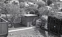
Outbuilding in next yard, southwest view from kitchen roof
https://search.heritageburnaby.ca/link/museumdescription10736
- Repository
- Burnaby Village Museum
- Date
- May 6, 1988
- Collection/Fonds
- Burnaby Village Museum fonds
- Description Level
- Item
- Physical Description
- 1 photograph : b&w negative ; 35 mm
- Scope and Content
- Photograph of outbuilding in yard next to the Love farmhouse located at 7651 Cumberland Street (the corner of 14th Avenue and Cumberland Street).
- Repository
- Burnaby Village Museum
- Collection/Fonds
- Burnaby Village Museum fonds
- Series
- Jesse Love farmhouse series
- Description Level
- Item
- Physical Description
- 1 photograph : b&w negative ; 35 mm
- Material Details
- Photograph is part of Film roll "C" - 36 b&w photographs that are a part of a collection described as BV018.41.83
- Scope and Content
- Photograph of outbuilding in yard next to the Love farmhouse located at 7651 Cumberland Street (the corner of 14th Avenue and Cumberland Street).
- Subjects
- Buildings - Heritage
- Geographic Access
- Cumberland Street
- Street Address
- 7651 Cumberland Street
- Accession Code
- BV018.41.259
- Access Restriction
- No restrictions
- Reproduction Restriction
- No known restrictions
- Date
- May 6, 1988
- Media Type
- Photograph
- Historic Neighbourhood
- East Burnaby (Historic Neighbourhood)
- Planning Study Area
- Cariboo-Armstrong Area
- Related Material
- See BV018.41.82 for File Level Description
- Scan Resolution
- 2400
- Scan Date
- 5/19/2019
- Scale
- 100
- Photographer
- Wolf, Jim
- Notes
- Title based on contents of photograph
- Photograph is a part of file level description "Photographic documentation of changes and move" BV018.41.82
Images
![Parker family tennis court, [between 1930 and 1940] (date of original), copied 1998 thumbnail](/media/hpo/_Data/_BVM_Images/2018/2018_0041_0175_001.jpg?width=280)
Parker family tennis court
https://search.heritageburnaby.ca/link/museumdescription9984
- Repository
- Burnaby Village Museum
- Date
- [between 1930 and 1940] (date of original), copied 1998
- Collection/Fonds
- Burnaby Village Museum fonds
- Description Level
- Item
- Physical Description
- 1 photograph : b&w negative ; 35 mm
- Scope and Content
- Photograph of members of the Parker family and friends holding tennis rackets and standing on a tennis court at 1390 Cumberland Road. People are identified from L to R as; Lucy Deacon, Sid Batton, Walter Harris, Elsie Parker, Maud, Albert Parker, Bill Parker, Elsie Parker, Jo Harris and William Par…
- Repository
- Burnaby Village Museum
- Collection/Fonds
- Burnaby Village Museum fonds
- Series
- Jesse Love farmhouse series
- Subseries
- Love family photographs subseries
- Description Level
- Item
- Physical Description
- 1 photograph : b&w negative ; 35 mm
- Scope and Content
- Photograph of members of the Parker family and friends holding tennis rackets and standing on a tennis court at 1390 Cumberland Road. People are identified from L to R as; Lucy Deacon, Sid Batton, Walter Harris, Elsie Parker, Maud, Albert Parker, Bill Parker, Elsie Parker, Jo Harris and William Parker. The tennis court was built by William Parker with help from his son Albert. The court was first made of dirt, then grass with wood layed across to flatten it out. In the late 1920s William made the court out of wood. William and Sarah (nee Love) Parker purchased the Love farmhouse at 1390 Cumberland Road in 1928 after Sarah's father, Jesse Love died. William and Sarah lived there with their three children Albert, Bill and Elsie until 1961.
- Subjects
- Buildings - Heritage
- Geographic Access
- Cumberland Street
- Street Address
- 7651 Cumberland Street
- Accession Code
- BV018.41.175
- Access Restriction
- No restrictions
- Reproduction Restriction
- May be restricted by third party rights
- Date
- [between 1930 and 1940] (date of original), copied 1998
- Media Type
- Photograph
- Historic Neighbourhood
- East Burnaby (Historic Neighbourhood)
- Planning Study Area
- Cariboo-Armstrong Area
- Scan Resolution
- 2400
- Scan Date
- 4-Mar-2019
- Scale
- 100
- Notes
- Title based on contents of photograph
- 1 b&w copy print accompanying
Images
![Parker family tennis court, [between 1930 and 1940] (date of original), copied 1998 thumbnail](/media/hpo/_Data/_BVM_Images/2018/2018_0041_0175_001.jpg)
![Parkers at pond, [between 1930 and 1940] (date of original), copied 1998 thumbnail](/media/hpo/_Data/_BVM_Images/2018/2018_0041_0168_001.jpg?width=280)
Parkers at pond
https://search.heritageburnaby.ca/link/museumdescription9982
- Repository
- Burnaby Village Museum
- Date
- [between 1930 and 1940] (date of original), copied 1998
- Collection/Fonds
- Burnaby Village Museum fonds
- Description Level
- Item
- Physical Description
- 1 photograph : sepia print ; 10.5 x 18 cm
- Scope and Content
- Photograph of four women and three men sitting outside of the Love farmhouse at 1390 Cumberland Road. The group is sitting amongst large rocks and a small pond. The kitchen of the Love farmhouse and the barn are behind them. A few of the people are holding tennis rackets. In 1928 after Sarah Parke…
- Repository
- Burnaby Village Museum
- Collection/Fonds
- Burnaby Village Museum fonds
- Series
- Jesse Love farmhouse series
- Subseries
- Love family photographs subseries
- Description Level
- Item
- Physical Description
- 1 photograph : sepia print ; 10.5 x 18 cm
- Scope and Content
- Photograph of four women and three men sitting outside of the Love farmhouse at 1390 Cumberland Road. The group is sitting amongst large rocks and a small pond. The kitchen of the Love farmhouse and the barn are behind them. A few of the people are holding tennis rackets. In 1928 after Sarah Parker's father, Jesse Love died, William and Sarah (nee Love) Parker purchased the Love farmhouse located at 1390 Cumberland Road. They lived there until 1961, with their three children; Albert, Bill and Elsie.
- Subjects
- Buildings - Heritage
- Sports - Tennis
- Geographic Access
- Cumberland Street
- Street Address
- 7651 Cumberland Street
- Accession Code
- BV018.41.168
- Access Restriction
- No restrictions
- Reproduction Restriction
- May be restricted by third party rights
- Date
- [between 1930 and 1940] (date of original), copied 1998
- Media Type
- Photograph
- Historic Neighbourhood
- East Burnaby (Historic Neighbourhood)
- Planning Study Area
- Cariboo-Armstrong Area
- Scan Resolution
- 600
- Scan Date
- 25-Feb-2019
- Scale
- 100
- Notes
- Title based on contents of photograph
- Photograph was copied from the Albert Parker photograph album in 1998
Images
![Parkers at pond, [between 1930 and 1940] (date of original), copied 1998 thumbnail](/media/hpo/_Data/_BVM_Images/2018/2018_0041_0168_001.jpg)
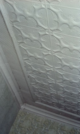
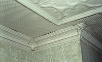
Parlour ceiling
https://search.heritageburnaby.ca/link/museumdescription10830
- Repository
- Burnaby Village Museum
- Date
- April 11, 1988
- Collection/Fonds
- Burnaby Village Museum fonds
- Description Level
- Item
- Physical Description
- 1 photograph : col. negative ; 35 mm
- Scope and Content
- Photograph of the tin ceiling in the parlour of the Love farmhouse while it was located at 7651 Cumberland Street (the corner of 14th Avenue and Cumberland Street).The photograph was taken of the house once it was saved and acquired by the Burnaby Village Museum.
- Repository
- Burnaby Village Museum
- Collection/Fonds
- Burnaby Village Museum fonds
- Series
- Jesse Love farmhouse series
- Description Level
- Item
- Physical Description
- 1 photograph : col. negative ; 35 mm
- Material Details
- Photograph is part of Film roll "G" - 36 colour photographs that are a part of a collection described as BV018.41.82
- Scope and Content
- Photograph of the tin ceiling in the parlour of the Love farmhouse while it was located at 7651 Cumberland Street (the corner of 14th Avenue and Cumberland Street).The photograph was taken of the house once it was saved and acquired by the Burnaby Village Museum.
- Subjects
- Buildings - Heritage
- Geographic Access
- Cumberland Street
- Street Address
- 7651 Cumberland Street
- Accession Code
- BV018.41.352
- Access Restriction
- No restrictions
- Reproduction Restriction
- No known restrictions
- Date
- April 11, 1988
- Media Type
- Photograph
- Historic Neighbourhood
- East Burnaby (Historic Neighbourhood)
- Planning Study Area
- Cariboo-Armstrong Area
- Related Material
- See BV018.41.82 for File Level Description
- Scan Resolution
- 2400
- Scan Date
- 27-May-19
- Scale
- 100
- Photographer
- Wolf, Jim
- Notes
- Title based on contents of photograph
- Photograph is a part of file level description "Photographic documentation of changes and move" BV018.41.82
Images

Parlour, view of ceiling
https://search.heritageburnaby.ca/link/museumdescription10828
- Repository
- Burnaby Village Museum
- Date
- April 11, 1988
- Collection/Fonds
- Burnaby Village Museum fonds
- Description Level
- Item
- Physical Description
- 1 photograph : col. negative ; 35 mm
- Scope and Content
- Photograph of the tin ceiling in the parlour of the Love farmhouse while it was located at 7651 Cumberland Street (the corner of 14th Avenue and Cumberland Street).The photograph was taken of the house once it was saved and acquired by the Burnaby Village Museum.
- Repository
- Burnaby Village Museum
- Collection/Fonds
- Burnaby Village Museum fonds
- Series
- Jesse Love farmhouse series
- Description Level
- Item
- Physical Description
- 1 photograph : col. negative ; 35 mm
- Material Details
- Photograph is part of Film roll "G" - 36 colour photographs that are a part of a collection described as BV018.41.82
- Scope and Content
- Photograph of the tin ceiling in the parlour of the Love farmhouse while it was located at 7651 Cumberland Street (the corner of 14th Avenue and Cumberland Street).The photograph was taken of the house once it was saved and acquired by the Burnaby Village Museum.
- Subjects
- Buildings - Heritage
- Geographic Access
- Cumberland Street
- Street Address
- 7651 Cumberland Street
- Accession Code
- BV018.41.350
- Access Restriction
- No restrictions
- Reproduction Restriction
- No known restrictions
- Date
- April 11, 1988
- Media Type
- Photograph
- Historic Neighbourhood
- East Burnaby (Historic Neighbourhood)
- Planning Study Area
- Cariboo-Armstrong Area
- Related Material
- See BV018.41.82 for File Level Description
- Scan Resolution
- 2400
- Scan Date
- 27-May-19
- Scale
- 100
- Photographer
- Wolf, Jim
- Notes
- Title based on contents of photograph
- Photograph is a part of file level description "Photographic documentation of changes and move" BV018.41.82
Images

Pioneer Days interviews September 22, 1971 - Track 1
https://search.heritageburnaby.ca/link/oralhistory266
- Repository
- City of Burnaby Archives
- Date Range
- 1891-1955
- Length
- 0:05:35
- Summary
- This portion of the recording includes Lillian May (Davies) Jones's memories of her family life during the early days of Burnaby, mentioning her family home as well as the home of Reeve Shaw. Lillian is being interviewed in front of an audience at Heritage Village (now Burnaby Village Museum).
- Repository
- City of Burnaby Archives
- Summary
- This portion of the recording includes Lillian May (Davies) Jones's memories of her family life during the early days of Burnaby, mentioning her family home as well as the home of Reeve Shaw. Lillian is being interviewed in front of an audience at Heritage Village (now Burnaby Village Museum).
- Date Range
- 1891-1955
- Length
- 0:05:35
- Historic Neighbourhood
- East Burnaby (Historic Neighbourhood)
- Planning Study Area
- Second Street Area
- Interview Date
- September 22, 1971
- Scope and Content
- Recording is of interviews with Lillian May (Davies) Jones, Ada Evelyn (Lewis) Groves, Lillian Frederica (Lewis) Porter, and Elsie Wilson during the Pioneer Days celebration at Heritage Village (now Burnaby Village Museum) on September 22, 1971. Major themes discussed are: personal memories and occupations of interviewees family members.
- Biographical Notes
- Lillian May Davies was born June 28, 1891 to George and Rachel (Mills) Davies. She was one of four children. George Davies married Rachel Mills September 12, 1888 in Winnipeg and headed west to make their home. George’s brother Richard Davies had already bought property at the corner of 16th Street and 3rd Avenue (now 12th Avenue) when Rachel and George moved in and built a house next door. George Davies went to work for Gilley Bros. Logging Co. in Burnaby. Lillian May Davies married John Henry Jones on July 29, 1909 at the Methodist Church in Burnaby which had opened only a few weeks before (the Joneses were the first couple to be married there). Their reception was held in the Davies’ family garden. On June 3, 1910, Lillian and John’s first child, Arnold Jones was born. In 1919 they adopted their second child, John Sheldon Jones whose birth parents had died of influenza. John and Lillian built a home on the lot next to Lillian’s parents and lived there for forty-eight years. After her husband’s death in 1956, Lillian moved one lot over and remained living there for over twenty years. Lillian May (Davies) Jones died in Surrey on June 24, 1981 at the age of eighty-nine for over twenty years. Lillian May (Davies) Jones died in Surrey on June 24, 1981 at the age of eighty-nine. Ada Evelyn Lewis was born on September 11, 1899. She was one of nine Lewis children. Ada's father came to Victoria BC from San Francisco. He met his wife in Victoria and moved to New Westminster where he was a typesetter on the first edition of the Columbian newspaper. He continued to work for the Columbian until his retirement. Her family owned the East Burnaby Fruit Farm at 17th Avenue between 2nd and 4th Street where they harvested apples, plums and pears. Ada attended East Burnaby School in 1905 and remembers being a pupil of Miss Draper. Ada E. Lewis married and became Mrs. Ada Evelyn Groves. Lillian Frederica “Lillie” Lewis was born in 1896 to William Henry and Emma (Smith) Lewis at the family farm at 4th Street and 18th Avenue. The family grew to nine, eldest to youngest; Albert, Lizzie, Minnie, Walter, Ernest, Lillie and Evelyn. Lillie’s mother, Emma (Smith) had the distinction of being the first girl of European descent to be born at Fort Victoria. Lillie’s father, William Henry Lewis helped to print the very first edition of the Vancouver Province in 1898. Lillie attended Douglas Road School and remembers being a pupil of Ellen Lister. Lillian Frederica “Lillie” Lewis married Bertie Blaine Porter at Lulu Island on November 7, 1918. They lived in Vancouver for a short time before returning to Burnaby to raise their four children. For most of his working life Bert operated a steam roller for the municipality. Lillian Frederica (Lewis) Porter died May 18, 1988 at the age of ninety-two. Elsie Wilson was born August 16, 1898 to Annie and her second husband William Wilson. Annie’s first husband Samuel W Walmsley died December 20, 1895 at the age of thirty-five, leaving Annie a widow at twenty-seven with two young children Annie age four and Samuel age six. Annie Walmsley married her second husband William Wilson on April 17, 1897. Elsie attended West Burnaby public school (later Kingsway West elementary) and remembers picking raspberries at various Burnaby farms for seven seasons.
- Total Tracks
- 4
- Total Length
- 0:24:19
- Interviewee Name
- Jones, Lillian May Davies
- Wilson, Elsie
- Porter, Lillie Lewis
- Groves, Ada Evelyn Lewis
- Interview Location
- Burnaby Village Museum, Burnaby
- Collection/Fonds
- Burnaby Historical Society fonds
- Subseries
- Oral history subseries
- Transcript Available
- None
- Media Type
- Sound Recording
- Web Notes
- Interview was digitized in 2010 allowing it to be accessible on Heritage Burnaby. The digitization project was initiated by the Community Heritage Commission with support from City of Burnaby Council and the BC History Digitization Program of the Irving K. Barber Learning Centre, University of British Columbia. It was recognized by the Heritage Society of BC with an award in 2012.
Audio Tracks
Track one of recording of Pioneer Days interviews
Track one of recording of Pioneer Days interviews
https://search.heritageburnaby.ca/media/hpo/_Data/_Archives_Oral_Histories/_Unrestricted/MSS137-020/MSS137-020_Track_1.mp3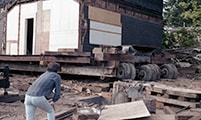
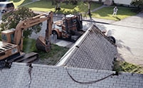
Preparing to move the Love farmhouse May 20, 1988
https://search.heritageburnaby.ca/link/museumdescription11004
- Repository
- Burnaby Village Museum
- Date
- May 20, 1988
- Collection/Fonds
- Burnaby Village Museum fonds
- Description Level
- Item
- Physical Description
- 1 photograph : col. negative ; 35 mm
- Scope and Content
- Photograph of the Love farmhouse located at 7651 Cumberland Street (the corner of 14th Avenue and Cumberland Street). The main part of the house is sitting on heavy steel I-beams in preparation for transport. The wall covered in white is where the kitchen extension was removed.
- Repository
- Burnaby Village Museum
- Collection/Fonds
- Burnaby Village Museum fonds
- Series
- Jesse Love farmhouse series
- Description Level
- Item
- Physical Description
- 1 photograph : col. negative ; 35 mm
- Material Details
- Photograph is part of Film roll "35-53" - 25 colour negatives and 18 colour photographs that are a part of a collection described as BV018.41.82
- Scope and Content
- Photograph of the Love farmhouse located at 7651 Cumberland Street (the corner of 14th Avenue and Cumberland Street). The main part of the house is sitting on heavy steel I-beams in preparation for transport. The wall covered in white is where the kitchen extension was removed.
- Subjects
- Buildings - Heritage
- Geographic Access
- Cumberland Street
- Street Address
- 7651 Cumberland Street
- Accession Code
- BV018.41.471
- Access Restriction
- No restrictions
- Reproduction Restriction
- No known restrictions
- Date
- May 20, 1988
- Media Type
- Photograph
- Historic Neighbourhood
- East Burnaby (Historic Neighbourhood)
- Planning Study Area
- Cariboo-Armstrong Area
- Related Material
- See BV018.41.82 for File Level Description
- Scan Resolution
- 2400
- Scan Date
- 3-Jun-19
- Scale
- 100
- Photographer
- Wolf, Jim
- Notes
- Title based on contents of photograph
- Photograph is a part of file level description "Photographic documentation of changes and move" BV018.41.82
Images

Preparing to move the Love farmhouse May 20, 1988
https://search.heritageburnaby.ca/link/museumdescription11007
- Repository
- Burnaby Village Museum
- Date
- May 20, 1988
- Collection/Fonds
- Burnaby Village Museum fonds
- Description Level
- Item
- Physical Description
- 1 photograph : col. negative ; 35 mm
- Scope and Content
- Photograph of the Love farmhouse located at 7651 Cumberland Street (the corner of 14th Avenue and Cumberland Street). The main part of the house is sitting on heavy steel I-beams with wheels in preparation for transport.
- Repository
- Burnaby Village Museum
- Collection/Fonds
- Burnaby Village Museum fonds
- Series
- Jesse Love farmhouse series
- Description Level
- Item
- Physical Description
- 1 photograph : col. negative ; 35 mm
- Material Details
- Photograph is part of Film roll "35-53" - 25 colour negatives and 18 colour photographs that are a part of a collection described as BV018.41.82
- Scope and Content
- Photograph of the Love farmhouse located at 7651 Cumberland Street (the corner of 14th Avenue and Cumberland Street). The main part of the house is sitting on heavy steel I-beams with wheels in preparation for transport.
- Subjects
- Buildings - Heritage
- Geographic Access
- Cumberland Street
- Street Address
- 7651 Cumberland Street
- Accession Code
- BV018.41.474
- Access Restriction
- No restrictions
- Reproduction Restriction
- No known restrictions
- Date
- May 20, 1988
- Media Type
- Photograph
- Historic Neighbourhood
- East Burnaby (Historic Neighbourhood)
- Planning Study Area
- Cariboo-Armstrong Area
- Related Material
- See BV018.41.82 for File Level Description
- Scan Resolution
- 2400
- Scan Date
- 3-Jun-19
- Scale
- 100
- Photographer
- Wolf, Jim
- Notes
- Title based on contents of photograph
- Photograph is a part of file level description "Photographic documentation of changes and move" BV018.41.82
Images

Preparing to move the Love farmhouse May 20, 1988
https://search.heritageburnaby.ca/link/museumdescription11011
- Repository
- Burnaby Village Museum
- Date
- May 20, 1988
- Collection/Fonds
- Burnaby Village Museum fonds
- Description Level
- Item
- Physical Description
- 1 photograph : col. negative ; 35 mm
- Scope and Content
- Photograph of the roof tops of the Love farmhouse loaded on a flatbed truck in preparation to move it to the site of the Burnaby Village Museum.
- Repository
- Burnaby Village Museum
- Collection/Fonds
- Burnaby Village Museum fonds
- Series
- Jesse Love farmhouse series
- Description Level
- Item
- Physical Description
- 1 photograph : col. negative ; 35 mm
- Material Details
- Photograph is part of Film roll "35-53" - 25 colour negatives and 18 colour photographs that are a part of a collection described as BV018.41.82
- Scope and Content
- Photograph of the roof tops of the Love farmhouse loaded on a flatbed truck in preparation to move it to the site of the Burnaby Village Museum.
- Subjects
- Buildings - Heritage
- Geographic Access
- Cumberland Street
- Street Address
- 7651 Cumberland Street
- Accession Code
- BV018.41.478
- Access Restriction
- No restrictions
- Reproduction Restriction
- No known restrictions
- Date
- May 20, 1988
- Media Type
- Photograph
- Historic Neighbourhood
- East Burnaby (Historic Neighbourhood)
- Planning Study Area
- Cariboo-Armstrong Area
- Related Material
- See BV018.41.82 for File Level Description
- Scan Resolution
- 2400
- Scan Date
- 3-Jun-19
- Scale
- 100
- Photographer
- Wolf, Jim
- Notes
- Title based on contents of photograph
- Photograph is a part of file level description "Photographic documentation of changes and move" BV018.41.82
Images
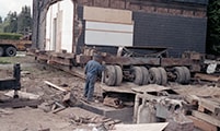
Preparing to move the Love farmhouse May 20, 1988
https://search.heritageburnaby.ca/link/museumdescription11014
- Repository
- Burnaby Village Museum
- Date
- May 20, 1988
- Collection/Fonds
- Burnaby Village Museum fonds
- Description Level
- Item
- Physical Description
- 1 photograph : col. negative ; 35 mm
- Scope and Content
- Photograph of the Love farmhouse kitchen on a flatbed truck in preparation to move the Love farmhouse to the site of the Burnaby Village Museum.
- Repository
- Burnaby Village Museum
- Collection/Fonds
- Burnaby Village Museum fonds
- Series
- Jesse Love farmhouse series
- Description Level
- Item
- Physical Description
- 1 photograph : col. negative ; 35 mm
- Material Details
- Photograph is part of Film roll "35-53" - 25 colour negatives and 18 colour photographs that are a part of a collection described as BV018.41.82
- Scope and Content
- Photograph of the Love farmhouse kitchen on a flatbed truck in preparation to move the Love farmhouse to the site of the Burnaby Village Museum.
- Subjects
- Buildings - Heritage
- Geographic Access
- Cumberland Street
- Street Address
- 7651 Cumberland Street
- Accession Code
- BV018.41.481
- Access Restriction
- No restrictions
- Reproduction Restriction
- No known restrictions
- Date
- May 20, 1988
- Media Type
- Photograph
- Historic Neighbourhood
- East Burnaby (Historic Neighbourhood)
- Planning Study Area
- Cariboo-Armstrong Area
- Related Material
- See BV018.41.82 for File Level Description
- Scan Resolution
- 2400
- Scan Date
- 3-Jun-19
- Scale
- 100
- Photographer
- Wolf, Jim
- Notes
- Title based on contents of photograph
- Photograph is a part of file level description "Photographic documentation of changes and move" BV018.41.82
Images


Preparing to move the Love farmhouse May 20, 1988
https://search.heritageburnaby.ca/link/museumdescription11016
- Repository
- Burnaby Village Museum
- Date
- May 20, 1988
- Collection/Fonds
- Burnaby Village Museum fonds
- Description Level
- Item
- Physical Description
- 1 photograph : col. negative ; 35 mm
- Scope and Content
- Photograph of the Love farmhouse kitchen on a flatbed truck in preparation to move the Love farmhouse to the site of the Burnaby Village Museum.
- Repository
- Burnaby Village Museum
- Collection/Fonds
- Burnaby Village Museum fonds
- Series
- Jesse Love farmhouse series
- Description Level
- Item
- Physical Description
- 1 photograph : col. negative ; 35 mm
- Material Details
- Photograph is part of Film roll "35-53" - 25 colour negatives and 18 colour photographs that are a part of a collection described as BV018.41.82
- Scope and Content
- Photograph of the Love farmhouse kitchen on a flatbed truck in preparation to move the Love farmhouse to the site of the Burnaby Village Museum.
- Subjects
- Buildings - Heritage
- Geographic Access
- Cumberland Street
- Street Address
- 7651 Cumberland Street
- Accession Code
- BV018.41.483
- Access Restriction
- No restrictions
- Reproduction Restriction
- No known restrictions
- Date
- May 20, 1988
- Media Type
- Photograph
- Historic Neighbourhood
- East Burnaby (Historic Neighbourhood)
- Planning Study Area
- Cariboo-Armstrong Area
- Related Material
- See BV018.41.82 for File Level Description
- Scan Resolution
- 2400
- Scan Date
- 3-Jun-19
- Scale
- 100
- Photographer
- Wolf, Jim
- Notes
- Title based on contents of photograph
- Photograph is a part of file level description "Photographic documentation of changes and move" BV018.41.82
Images

![Raising the flag, [between 1939 and 1947] (date of original), copied 2014 thumbnail](/media/hpo/_Data/_Archives_Images/_Unrestricted/580/581-006.jpg?width=280)
Raising the flag
https://search.heritageburnaby.ca/link/archivedescription88400
- Repository
- City of Burnaby Archives
- Date
- [between 1939 and 1947] (date of original), copied 2014
- Collection/Fonds
- James Massey family fonds
- Description Level
- Item
- Physical Description
- 1 photograph (tiff) : sepia ; 600 dpi
- Scope and Content
- Photograph of James Massey as he raises the Union Jack flag up the flag pole in Robert Burnaby Park. James Massey was the caretaker of the park from 1933 until 1947 and raised the flag on all public holidays.
- Repository
- City of Burnaby Archives
- Date
- [between 1939 and 1947] (date of original), copied 2014
- Collection/Fonds
- James Massey family fonds
- Physical Description
- 1 photograph (tiff) : sepia ; 600 dpi
- Description Level
- Item
- Record No.
- 581-006
- Access Restriction
- No restrictions
- Reproduction Restriction
- No restrictions
- Accession Number
- 2014-34
- Scope and Content
- Photograph of James Massey as he raises the Union Jack flag up the flag pole in Robert Burnaby Park. James Massey was the caretaker of the park from 1933 until 1947 and raised the flag on all public holidays.
- Subjects
- Symbols - Flags
- Names
- Massey, James
- Media Type
- Photograph
- Notes
- Title based on contents of photograph
- Historic Neighbourhood
- East Burnaby (Historic Neighbourhood)
- Planning Study Area
- Lakeview-Mayfield Area
Images
![Raising the flag, [between 1939 and 1947] (date of original), copied 2014 thumbnail](/media/hpo/_Data/_Archives_Images/_Unrestricted/580/581-006.jpg)

Savoy Place
https://search.heritageburnaby.ca/link/archivedescription98668
- Repository
- City of Burnaby Archives
- Date
- 2022
- Collection/Fonds
- Disappearing Burnaby collection
- Description Level
- Item
- Physical Description
- 1 photograph (jpeg) : col.
- Scope and Content
- Photograph of the exterior of Savoy Place, an apartment complex located at 6355 Kingsway, at night. The building was constructed in 1968. Two people are standing in the illuminated lobby of the building, and wings of the building flank either side of the entrance, with trees and bushes lining the s…
- Repository
- City of Burnaby Archives
- Date
- 2022
- Collection/Fonds
- Disappearing Burnaby collection
- Physical Description
- 1 photograph (jpeg) : col.
- Description Level
- Item
- Record No.
- 634-015
- Access Restriction
- No restrictions
- Reproduction Restriction
- No restrictions
- Accession Number
- 2022-14
- Scope and Content
- Photograph of the exterior of Savoy Place, an apartment complex located at 6355 Kingsway, at night. The building was constructed in 1968. Two people are standing in the illuminated lobby of the building, and wings of the building flank either side of the entrance, with trees and bushes lining the sidewalk.
- Media Type
- Photograph
- Photographer
- Cheung, Nakita
- Notes
- Title taken from the associated blog post
- Associated blog post: https://disappearingburnaby.wordpress.com/2022/05/19/savoy-place/
- Geographic Access
- Kingsway
- Street Address
- 6355 Kingsway
- Historic Neighbourhood
- East Burnaby (Historic Neighbourhood)
- Planning Study Area
- Kingsway-Beresford Area
Images
