Northwest elevation of Love farmhouse
https://search.heritageburnaby.ca/link/museumdescription2164
- Repository
- Burnaby Village Museum
- Date
- 04-May-88
- Collection/Fonds
- Burnaby Village Museum fonds
- Description Level
- Item
- Physical Description
- 1 photograph : col. negative ; 35 mm
- Scope and Content
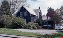
- Photograph of the northwest elevation of the Love farmhouse located at 7651 Cumberland Street (the corner of 14th Avenue and Cumberland Street).The photograph was taken of the house once it was saved and acquired by the Burnaby Village Museum. Kitchen and driveway are visible.
- Repository
- Burnaby Village Museum
- Collection/Fonds
- Burnaby Village Museum fonds
- Series
- Jesse Love farmhouse series
- Description Level
- Item
- Physical Description
- 1 photograph : col. negative ; 35 mm
- Material Details
- Photograph is part of Film roll "A"- 15 colour prints that are a part of a collection described as BV018.41.82
- Scope and Content
- Photograph of the northwest elevation of the Love farmhouse located at 7651 Cumberland Street (the corner of 14th Avenue and Cumberland Street).The photograph was taken of the house once it was saved and acquired by the Burnaby Village Museum. Kitchen and driveway are visible.
- Subjects
- Buildings - Heritage
- Geographic Access
- Cumberland Street
- Street Address
- 7651 Cumberland Street
- Accession Code
- BV018.41.212
- Access Restriction
- No restrictions
- Reproduction Restriction
- No known restrictions
- Date
- 04-May-88
- Media Type
- Photograph
- Historic Neighbourhood
- East Burnaby (Historic Neighbourhood)
- Planning Study Area
- Cariboo-Armstrong Area
- Related Material
- See BV018.41.82 for File Level Description
- Scan Resolution
- 2400
- Scan Date
- 5/19/2019
- Scale
- 100
- Photographer
- Wolf, Jim
- Notes
- Title based on contents of photograph
- Photograph is a part of file level description "Photographic documentation of changes and move" BV018.41.82
Images
