England House
https://search.heritageburnaby.ca/link/landmark501
- Repository
- Burnaby Heritage Planning
- Description
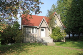
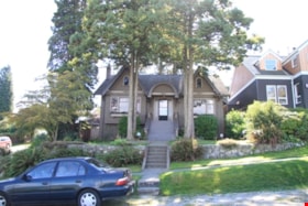
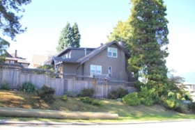
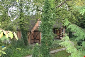
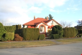
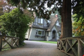
- The Mary England Residence is a one and one-half storey, wood-frame, Period Revival cottage with a steeply pitched, cross-gabled roof. Situated on Griffiths Drive within the Edmonds neighbourhood of Burnaby, the Mary England Residence has an original attached garage.
- Associated Dates
- 1930
- Formal Recognition
- Community Heritage Register
- Other Names
- Mary England Residence
- Street View URL
- Google Maps Street View
- Repository
- Burnaby Heritage Planning
- Other Names
- Mary England Residence
- Geographic Access
- Griffiths Drive
- Associated Dates
- 1930
- Formal Recognition
- Community Heritage Register
- Enactment Type
- Council Resolution
- Enactment Date
- 26/05/2003
- Description
- The Mary England Residence is a one and one-half storey, wood-frame, Period Revival cottage with a steeply pitched, cross-gabled roof. Situated on Griffiths Drive within the Edmonds neighbourhood of Burnaby, the Mary England Residence has an original attached garage.
- Heritage Value
- The Mary England Residence, built in 1930, is valued as a representation of the period revival styles that were popular in the era between the two World Wars. At this time, it was considered the height of fashion for a house to reflect historical styles, even when combined in an eclectic manner, that expressed a domestic ideal of cozy traditionalism. The Mary England Residence is an exuberant example of this trend. Half-timbering, multi-paned and leaded casement windows and a steeply pitched, cross-gabled roof impart a storybook cottage charm. Its first owner, Mary England, was employed for several years as stenographer at the old Burnaby Municipal Hall. An original attached garage is evidence of the growing presence of automobiles in domestic life of the 1930s. Additionally, the Mary England Residence is a testament to the continued suburban growth of the Edmonds neighbourhood. During the Edwardian era, the area experienced a housing boom. Its proximity to New Westminster, coupled with its regional transportation links, made it an attractive area for middle-class residences. Despite the economic recession of the 1930s, the Edmonds area continued to develop with modest but handsome housing.
- Defining Elements
- Key elements that define the heritage character of the Mary England Residence: - location, in the Edmonds neighbourhood of East Burnaby - residential form, scale and massing as expressed by its one and one-half storey height with full basement, rectangular plan and steeply pitched cross-gabled roof - Period Revival elements such as rough-cast stucco, half-timbering, minimal eave overhangs, arched entry with glazed wooden front door, and arched-top feature window - mixture of windows including: double-hung, multi-paned wooden sash windows in double assembly; 6-over-1 double-hung wooden sash windows in multiple assembly; multi-paned casement windows; and straight-leaded feature windows - external parged chimney and two internal chimneys - attached front-gabled garage - associated landscape features including mature deciduous trees and fruit trees
- Historic Neighbourhood
- Edmonds (Historic Neighbourhood)
- Planning Study Area
- Stride Avenue Area
- Function
- Primary Historic--Single Dwelling
- Primary Current--Single Dwelling
- Community
- Edmonds
- Cadastral Identifier
- P.I.D.011-115-424
- Boundaries
- The Mary England Residence is comprised of a single residential lot located at 7276 Griffiths Drive, Burnaby.
- Area
- 1404.26
- Contributing Resource
- Building
- Ownership
- Public (local)
- Documentation
- City of Burnaby Planning and Building Department, Heritage Site Files
- Street Address
- 7276 Griffiths Drive
- Street View URL
- Google Maps Street View
Images
East Burnaby Neighbourhood
https://search.heritageburnaby.ca/link/landmark712
- Repository
- Burnaby Heritage Planning
- Associated Dates
- 1925-1954
- Heritage Value
- After a lull in construction during the World War I period, East Burnaby Neighbourhood's growth resumed during the 1920s when many homes and businesses were constructed. The post-World War Two period also saw rapid construction and the creation of new housing developments in response to a population boom. The neighbourhood remained a primarily single-family residential area.
- Historic Neighbourhood
- Edmonds (Historic Neighbourhood)
- Planning Study Area
- Stride Avenue Area
Images
Agnes & Elizabeth Michie Residence
https://search.heritageburnaby.ca/link/landmark554
- Repository
- Burnaby Heritage Planning
- Description
- Residential building.
- Associated Dates
- c.1935
- Street View URL
- Google Maps Street View
- Repository
- Burnaby Heritage Planning
- Geographic Access
- Yale Street
- Associated Dates
- c.1935
- Description
- Residential building.
- Heritage Value
- This interwar bungalow is beautifully preserved and retains many original features. Symmetrical in design, with two steeply-pitched front gables that flank a central arched gable over the front entrance, it also retains its narrow arched windows and projecting purlins in the front gables. Narrow sidelights flank the front door. The matching front elevation windows are typical of the period, with double-hung sash flanking a plate glass “picture window” with a curved transom; the upper panes are cross-leaded. This house was built by Agnes Michie and Elizabeth D. Michie.
- Locality
- Vancouver Heights
- Historic Neighbourhood
- Vancouver Heights (Historic Neighbourhood)
- Planning Study Area
- Burnaby Heights Area
- Ownership
- Private
- Street Address
- 3894 Yale Street
- Street View URL
- Google Maps Street View
Images
Alta Vista Neighbourhood
https://search.heritageburnaby.ca/link/landmark707
- Repository
- Burnaby Heritage Planning
- Associated Dates
- 1925-1954
- Heritage Value
- As with many areas of Burnaby during this period, the years after World War Two marked a rapid growth in residential development in the Alta-Vista Neighbourhood. Subdivisions like Sussex and Suncrest were built and new schools and amenities were constructed to meet the demands of increased population.
- Historic Neighbourhood
- Alta Vista (Historic Neighbourhood)
- Planning Study Area
- Sussex-Nelson Area
Images
Burquitlam Neighbourhood
https://search.heritageburnaby.ca/link/landmark703
- Repository
- Burnaby Heritage Planning
- Associated Dates
- 1925-1954
- Heritage Value
- By the 1950s, the Burquitlam Neighbourhood was becoming a residential and commercial centre for the northeast section of Burnaby. The Sullivan Heights area was developed as a single-family residential area with the Lyndhurst School opening in 1954. The completion of the Lougheed Highway in 1953 encouraged more commercial and retail development and fostered the growth of the neighbourhood throughout this period.
- Historic Neighbourhood
- Burquitlam (Historic Neighbourhood)
- Planning Study Area
- Lyndhurst Area
Images
Central Park Neighbourhood
https://search.heritageburnaby.ca/link/landmark688
- Repository
- Burnaby Heritage Planning
- Associated Dates
- 1925-1954
- Heritage Value
- Although still largely a rural area during the 1920s, subdivisions began appearing in the Central Park neighbourhood at this time. Development was slowed by the Great Depression of the 1930s but the influx of commercial buildings and new housing initiatives in the post-war boom led to a period of rapid growth especially in the Garden Village subdivision which was undertaken in 1953 with the plan to build 500 modern homes in the 140-acre site. Despite the closure of the interurban line in 1953, the neighbourhood remained an active commercial and residential centre.
- Historic Neighbourhood
- Central Park (Historic Neighbourhood)
- Planning Study Area
- Maywood Area
Images
Douglas-Gilpin Neighbourhood
https://search.heritageburnaby.ca/link/landmark799
- Repository
- Burnaby Heritage Planning
- Associated Dates
- 1955-2008
- Heritage Value
- The Douglas-Gilpin Neighbourhood developed into a diverse area incorporating residential, business, educational and park districts in the period after 1955. The BCIT site was built in the early 1960s, shortly after the Burnaby Municipal Hall was located on Canada Way near Deer Lake in 1956. The construction of the Municipal Hall at this location fostered the creation of an administrative and business centre adjacent to the park, while the northern and central areas of the neighbourhood retained their primarily residential character.
- Historic Neighbourhood
- Burnaby Lake (Historic Neighbourhood)
- Planning Study Area
- Douglas-Gilpin Area
Images
Edmonds Neighbourhood
https://search.heritageburnaby.ca/link/landmark704
- Repository
- Burnaby Heritage Planning
- Associated Dates
- 1925-1954
- Heritage Value
- The historic growth of Edmonds as a neighbourhood was based on its strategic location on the early interurban line between Vancouver and New Westminster. Even by 1980 when a survey of the residential neighbourhoods was conducted, a full 25% of homes in the area predated 1930. The 1950s was a period of strong housing development, with both single-family and multi-family units being constructed. Although Burnaby's City Hall was moved from Kingsway and Edmonds in the early 1950s, Edmonds remained an important centre in the community.
- Historic Neighbourhood
- Edmonds (Historic Neighbourhood)
- Planning Study Area
- Stride Avenue Area
Images
Hans & Anna Hau Residence
https://search.heritageburnaby.ca/link/landmark588
- Repository
- Burnaby Heritage Planning
- Description
- Residential building.
- Associated Dates
- c.1935
- Street View URL
- Google Maps Street View
- Repository
- Burnaby Heritage Planning
- Geographic Access
- Canada Way
- Associated Dates
- c.1935
- Description
- Residential building.
- Heritage Value
- Danish builder Hans Jorgensen Hau (1878-1944) and his wife Anna (née Sorenson, 1874-1956), constructed this highly-distinctive Tudor Revival residence circa 1935. This was a time of entrenched traditionalism, and most domestic architecture reflected period revival styles. Tudor elements have been compressed here into a cottage form, including a distinctive front façade with half timbering and brick noggin; on the sides the nogging is rock-dash stucco. Casement windows contribute to the cottage appearance. The rear façade is clad with more utilitarian shingles. A prominent brick chimney exhibits angled and corbelled brickwork. Hau worked as a bricklayer and stonemason, and this house has common elements with the Moore Residence at 5165 Sperling Avenue, which Hau designed and constructed in 1943.
- Locality
- Burnaby Lake
- Historic Neighbourhood
- Burnaby Lake (Historic Neighbourhood)
- Planning Study Area
- Morley-Buckingham Area
- Area
- 2010.52
- Contributing Resource
- Building
- Ownership
- Private
- Street Address
- 5070 Canada Way
- Street View URL
- Google Maps Street View
Images
Lozells Neighbourhood
https://search.heritageburnaby.ca/link/landmark701
- Repository
- Burnaby Heritage Planning
- Associated Dates
- 1925-1954
- Heritage Value
- Like a lot of residential neighbourhoods in Burnaby during the post-War boom, the Lozells area during the 1925-1954 period was one of new construction and subdivisions. Although more homes were being built, the neighbourhood still retained a somewhat rural characteristic well into the 1950s.
- Historic Neighbourhood
- Lozells (Historic Neighbourhood)
- Planning Study Area
- Government Road Area
Images
Mary McNeil Residence
https://search.heritageburnaby.ca/link/landmark620
- Repository
- Burnaby Heritage Planning
- Description
- Residential building.
- Associated Dates
- 1930
- Street View URL
- Google Maps Street View
- Repository
- Burnaby Heritage Planning
- Geographic Access
- MacDonald Avenue North
- Associated Dates
- 1930
- Description
- Residential building.
- Heritage Value
- Built for Mary McNeil, this house is a well-preserved example of an interwar Period Revival cottage, combining eclectic elements such as curved entrance porch buttresses, rolled roof edges, round-arched windows, smooth stucco cladding and imitation voussoirs. The house retains its original window sash with leaded glass panes.
- Locality
- Vancouver Heights
- Historic Neighbourhood
- Vancouver Heights (Historic Neighbourhood)
- Planning Study Area
- Burnaby Heights Area
- Area
- 566.71
- Contributing Resource
- Building
- Ownership
- Private
- Street Address
- 310 Macdonald Avenue North
- Street View URL
- Google Maps Street View
Images
Suncrest Neighbourhood
https://search.heritageburnaby.ca/link/landmark839
- Repository
- Burnaby Heritage Planning
- Associated Dates
- 1955-2008
- Heritage Value
- The Suncrest Neighbourhood is a small residential area south of Burnaby's Central Park. The Ocean View Burial Park takes up a large area of land in the north-east corner of this neighbourhood and the majority of the housing was built during the 1930-1960 period.
- Historic Neighbourhood
- Alta Vista (Historic Neighbourhood)
- Planning Study Area
- Suncrest Area
Images
Vancouver Heights Neighbourhood
https://search.heritageburnaby.ca/link/landmark666
- Repository
- Burnaby Heritage Planning
- Associated Dates
- 1925-1954
- Heritage Value
- Vancouver Heights remained an important residential and commercial centre in Burnaby throughout the 1925-1954 period. The area had its own Board of Trade and the North Burnaby Library was created to serve the residents. In 1949, the Hastings streetcars stopped running, but the area retained its reputation as one of the best shopping districts in the city.
- Historic Neighbourhood
- Vancouver Heights (Historic Neighbourhood)
- Planning Study Area
- Burnaby Heights Area
Images
William & Annie Mawhinney Residence
https://search.heritageburnaby.ca/link/landmark653
- Repository
- Burnaby Heritage Planning
- Description
- Residential building.
- Associated Dates
- c.1930
- Street View URL
- Google Maps Street View
- Repository
- Burnaby Heritage Planning
- Geographic Access
- Buckingham Avenue
- Associated Dates
- c.1930
- Description
- Residential building.
- Heritage Value
- Local farmers William Alexander Mawhinney (1870-1953) and Annie Josephine Mawhinney (née Sutcliff, 1871-1956) built this residence as their retirement home. It was the last of several houses built in the immediate vicinity by members of the Mawhinney family between 1909 and 1930. Born in Ireland, William Mawhinney first came to Burnaby to help his brother Isaiah establish his fruit farm. Due to his farm management experience, in 1908 William became foreman of the Avalon estate at Deer Lake that was owned by F.J. Hart. When he retired in 1930, William had fifty years of experience as a fruit and grain farmer.This house is situated on its lot at an angle, rather than parallel to the street, to take advantage of the view of wooded Buckingham Creek that runs through the northeast section of the property. Complementing the picturesque character of the property is this charming cottage-style residence, which is an excellent example of an interwar Storybook Cottage. During the years between the two World Wars, domestic styles in North America were resolutely historicist. In order to display good taste, it was expected that a house would have an identifiable period revival style. As economics dictated that houses of the time were generally modest, they often assumed a cottage appearance that provided a romantic ideal of traditional domesticity. The American Sesquicentennial reinforced this historicist trend, and the most popular Hollywood movies of the time were swashbuckling costume dramas. With its distinctive roughcast stucco and half-timbering, this house is an excellent example of this housing trend. The rolled roof edges, with steam-bent cedar shingles, simulate a traditional thatched roof. Other picturesque features include a front porch with round-arched openings, battered wall buttresses, an oriel window and diamond-paned leaded casement windows.
- Locality
- Burnaby Lake
- Historic Neighbourhood
- Burnaby Lake (Historic Neighbourhood)
- Planning Study Area
- Morley-Buckingham Area
- Area
- 1848.00
- Contributing Resource
- Building
- Ownership
- Private
- Street Address
- 6011 Buckingham Avenue
- Street View URL
- Google Maps Street View
Images
Willingdon Heights Neighbourhood
https://search.heritageburnaby.ca/link/landmark777
- Repository
- Burnaby Heritage Planning
- Associated Dates
- 1955-2008
- Heritage Value
- The convenient location of Willingdon Heights to the Trans Canada Highway, Lougheed Highway and Hastings Street has fostered its development as a primarily residential commuter neighbourhood. Characterised in the post-World War Two period by predominantly single-family developments, the neighbourhood has retained this identity despite some higher density apartment buildings now found there.
- Planning Study Area
- Willingdon Heights Area
Images
Century Park Museum Association fonds
https://search.heritageburnaby.ca/link/museumdescription3781
- Repository
- Burnaby Village Museum
- Date
- 1971-1989
- Collection/Fonds
- Century Park Museum Association fonds
- Description Level
- Fonds
- Physical Description
- 1814 photographs + 219 architectural drawings + 17 technical drawings + 4 videocassettes + 3 audio reels + 17 audio cassettes + 1.6 m of textual records + 2 maps
- Scope and Content
- Fonds consists of records created and collected by the Century Park Museum Association (renamed Burnaby Village Museum Association after 1984), which managed Heritage Village (later named Burnaby Village Museum) from its opening in 1971 until it's dissolution in December 1989. Records include archi…
- Repository
- Burnaby Village Museum
- Collection/Fonds
- Century Park Museum Association fonds
- Description Level
- Fonds
- Physical Description
- 1814 photographs + 219 architectural drawings + 17 technical drawings + 4 videocassettes + 3 audio reels + 17 audio cassettes + 1.6 m of textual records + 2 maps
- Scope and Content
- Fonds consists of records created and collected by the Century Park Museum Association (renamed Burnaby Village Museum Association after 1984), which managed Heritage Village (later named Burnaby Village Museum) from its opening in 1971 until it's dissolution in December 1989. Records include architectural drawings and proposals; photographs and films of the site; documentation of exhibits and artifacts, special events and programs; oral history interviews and other sound recordings; association meeting minutes; constitutions and bylaws; financial records; reports; correspondence; publications and research materials. Fonds has been arranged into the following series: 1) Century Park Museum Association photograph collection series 2) Century Park Museum Association film collection series 3) Century Park Museum Association architectural records and reports series 4) Heritage Village Museum oral history Interviews series 5) Heritage Village Museum presentations and Programming series 6) Century Park Museum Association reports series 7) Century Park Museum Association constitution, bylaws and agreements series 8) Century Park Museum Association minutes of meetings series 9) Century Park Museum association Board of Directors' administrative files series 10) Century Park Museum membership series 11) Heritage Village Museum exhibits and artifacts series 12) Century Park Museum Association committees' minutes and reports series 13) Museum staff adminstrative files series 14) Century Park Museum Association financial records series
- History
- The Heritage Village Museum was originally created as a British Columbia Centennial Project in 1971 through funding from the Federal, Provincial and Municipal governments. A sub-committee of the Burnaby Centennial '71 Committee was responsible for the creation of a permanent commemorative project. The concept for an open-air museum was developed with the location to be in Burnaby on lots 8,9, 10 and 11 of District Lot 79 and Lots 2 and 5, Block "R" of Districts Lots 79 and 85. The official sod turning for Heritage Village took place on April 11, 1971. In the spring of 1971, a museum director and curator were hired to oversee the development of the project and the acquisition of artifacts with funding from the Parks and Recreation Commission. The Century Park Museum Association (CPMA) was founded under the auspices of the Burnaby Centennial '71 Committee to govern Burnaby's Centennial '71 Commemorative Project, Heritage Village. The CPMA Board of directors were elected on October 26, 1971 with Donald (Don) Copan as the founding president (Don continued to serve on the Board until 1989). The Board of Directors reported directly to the Municipal Council. The association had an overall objective of providing a museum that was a historical resource for Burnaby and the region. The museum mandate was to collect, preserve, research, document and interpret artifacts and historical buildings that illustrated the history and lifestyle of the Lower Mainland in B.C. and Burnaby. The Museum focused on the period between 1890 and 1925 depicting a village lifestyle of a small community. This was achieved through the use of exhibits and displays within historic buildings and built reconstructions along with costumed museum interpreters. Many people contributed to the construction and design of the village. Architect, Rudy Kovach created the initial concept drawings and architecture designs were created by architectural design consultants Hopping, Kovach and Grinnell. Many carpenters and tradespeople worked on the construction of the buildings including Mr. Angelo Giacometti who was respsonible for much of the final decorative elements. The official opening of Heritage Village took place on November 19, 1971 with Burnaby Mayor Bob Prittie and Canada’s Governor General Roland Michener. Heritage Village was opened up to the public for a few days between November 19 and 21 with approximately 15,000 visitors. On July 1st, 1972 Heritage Village re-opened for the summer season with CPMA president, Don Copan and Mayor Bob Prittie officiating. This opening showcased further development of the site with more buildings and exhibits added. In 1984, Heritage Village Museum changed its name to “Burnaby Village Museum” and in turn, the Century Park Museum Association changed its name to the “Burnaby Village Museum Association”. Burnaby Village Museum continued to be governed by the Burnaby Village Museum Association until the end of 1989. In 1990, the Corporation of the District of Burnaby assumed the operation and management of Burnaby Village Museum under the Parks, Recreation and Cultural Services Department and the Burnaby Village Museum Association was dissolved.
- Responsibility
- Century Park Museum Association
- Accession Code
- BV985.6028
- BV005.14
- BV000.18
- BV011.44
- BV011.50
- BV014.30
- BV016.56
- BV017.46
- BV018.21
- BV019.52
- BV020.4
- BV020.5
- BV021.5
- BV022.9
- Date
- 1971-1989
- Media Type
- Photograph
- Sound Recording
- Textual Record
- Architectural Drawing
- Moving Images
- Cartographic Material
- Technical Drawing
- Related Material
- Donald Copan fonds
- Burnaby Centennial '71 Committee collection
- Royal Bank exhibit collection
- Bell's Dry Goods exhibit collection
- Jesse Love farmhouse fonds
- Burnaby Village Museum fonds
- Arrangement
- Records are arranged by types and functions of the Century Park Museum Association. The series reflects how they were maintained by the associaton, it's members and staff of Heritage Village (Burnaby Village Museum) while under the governance of the association.
- Notes
- Title based on contents of fonds
- Further accruals are expected
- Some records within this fonds are Closed - contact Burnaby Village Museum for access
Joseph H.C. Corsbie fonds
https://search.heritageburnaby.ca/link/museumdescription20275
- Repository
- Burnaby Village Museum
- Date
- [1941-1988]
- Collection/Fonds
- Joseph H.C. Corsbie fonds
- Description Level
- Fonds
- Physical Description
- 35 photographs + 1.5 cm textual records + 1 map + 1 book
- Scope and Content
- Fonds consists of photographs and documents relating to Joseph (Joe) Hardcastle Cumberland Corsbie during his service with the RCAF during World War II (1942-1945) along with photographs and docments relating to his personal and professional life (. Fonds is arranged into series: 1) Joseph H.C. Co…
- Repository
- Burnaby Village Museum
- Collection/Fonds
- Joseph H.C. Corsbie fonds
- Description Level
- Fonds
- Physical Description
- 35 photographs + 1.5 cm textual records + 1 map + 1 book
- Scope and Content
- Fonds consists of photographs and documents relating to Joseph (Joe) Hardcastle Cumberland Corsbie during his service with the RCAF during World War II (1942-1945) along with photographs and docments relating to his personal and professional life (. Fonds is arranged into series: 1) Joseph H.C. Corsbie RCAF records series 2) Joseph H.C. Corsbie personal and professional records series
- History
- Joseph “Joe” Hardcastle Cumberland Corsbie was born in 1913 in Peace River (Doe River) to parents Joseph Hardcastle Cumberland Corsbie and Winnifred Ann Mapleton Corsbie. As an adult Joe trained and served with the Royal Canadian Air Force as a navigator between 1942 and 1945. In 1945, while serving with the RCAF during World War II, Joe was awarded the Distinguished Flying Cross. After World War II, Joe returned to Peace River where he was elected as a Member of the Legislative Assembly serving as a Co-operative Commonwealth Federation MLA for one term between 1945 and 1948. In April 1948, Joe Corsbie married Margaret Carr in the Metropolitan United Church in Victoria followed by a reception held at the B.C. Legislature buildings. On their wedding day, the couple were honoured with a hand painted congratulatory certificate signed by members of the B.C. Legislature. In late, 1948, Joe lost the election and moved with his wife Margaret to Black Creek, B.C. to manage a co-op store. In 1949, the couple welcome their first child who they named Margaret after her mother. In 1950, Joe, Margaret and their daughter moved to a home on Charles Street in Burnaby and Joe began working as the General Manager of the Gulf and Fraser Fishermen’s Credit Union. In 1951, Joe and Margaret welcomed their second child, named Josesph after his father and in 1952, Joe, Margaret and family moved to 84 Springer Avenue, Burnaby where they lived until 1989. Between 1959 and 1976, Joe worked as a General Manager for the CU & C Health Services Society (later became Pacific Blue Cross). While working there, he focused on organizing both extended healthcare benefits and dental coverage for employee groups. In 1964, Joe Corsbie was elected to Burnaby Municipal Council and served one term between 1964 and 1968. Joe also served on the Burnaby Parks Commission (after 1968); served on the Board of Directors for Heritage Village, worked for a short period as a temporary curator for Heritage Village, represented the United Church in organizing and building St. Michael’s Care Centre and served on the Board of Director's. Joe Corsbie died in 1992 and his wife Margaret Corsbie died in 2004.
- Accession Code
- BV020.31
- Access Restriction
- No restrictions
- Reproduction Restriction
- No known restrictions
- Date
- [1941-1988]
- Media Type
- Photograph
- Textual Record
- Cartographic Material
- Arrangement
- Arrangement of fonds is based on the original arrangement by donor.
- Notes
- Title based on contents of fonds
