Narrow Results By
Subject
- Advertising Medium - Signs and Signboards 2
- Aerial Photographs 2
- Agriculture - Farms 1
- Animals - Birds 4
- Buildings - Heritage 1
- Buildings - Recreational 5
- Buildings - Residential - Houses 1
- Education 1
- Geographic Features - Lakes and Ponds 11
- Migration 1
- Natural Phenomena - Snow 1
- Occupations - Teachers 4

William & Annie Mawhinney Residence
https://search.heritageburnaby.ca/link/landmark653
- Repository
- Burnaby Heritage Planning
- Description
- Residential building.
- Associated Dates
- c.1930
- Street View URL
- Google Maps Street View
- Repository
- Burnaby Heritage Planning
- Geographic Access
- Buckingham Avenue
- Associated Dates
- c.1930
- Description
- Residential building.
- Heritage Value
- Local farmers William Alexander Mawhinney (1870-1953) and Annie Josephine Mawhinney (née Sutcliff, 1871-1956) built this residence as their retirement home. It was the last of several houses built in the immediate vicinity by members of the Mawhinney family between 1909 and 1930. Born in Ireland, William Mawhinney first came to Burnaby to help his brother Isaiah establish his fruit farm. Due to his farm management experience, in 1908 William became foreman of the Avalon estate at Deer Lake that was owned by F.J. Hart. When he retired in 1930, William had fifty years of experience as a fruit and grain farmer.This house is situated on its lot at an angle, rather than parallel to the street, to take advantage of the view of wooded Buckingham Creek that runs through the northeast section of the property. Complementing the picturesque character of the property is this charming cottage-style residence, which is an excellent example of an interwar Storybook Cottage. During the years between the two World Wars, domestic styles in North America were resolutely historicist. In order to display good taste, it was expected that a house would have an identifiable period revival style. As economics dictated that houses of the time were generally modest, they often assumed a cottage appearance that provided a romantic ideal of traditional domesticity. The American Sesquicentennial reinforced this historicist trend, and the most popular Hollywood movies of the time were swashbuckling costume dramas. With its distinctive roughcast stucco and half-timbering, this house is an excellent example of this housing trend. The rolled roof edges, with steam-bent cedar shingles, simulate a traditional thatched roof. Other picturesque features include a front porch with round-arched openings, battered wall buttresses, an oriel window and diamond-paned leaded casement windows.
- Locality
- Burnaby Lake
- Historic Neighbourhood
- Burnaby Lake (Historic Neighbourhood)
- Planning Study Area
- Morley-Buckingham Area
- Area
- 1848.00
- Contributing Resource
- Building
- Ownership
- Private
- Street Address
- 6011 Buckingham Avenue
- Street View URL
- Google Maps Street View
Images


Backyard Fence at 5573 Buckingham Avenue
https://search.heritageburnaby.ca/link/archivedescription78982
- Repository
- City of Burnaby Archives
- Date
- September 24, 1976
- Collection/Fonds
- Burnaby Public Library Contemporary Visual Archive Project
- Description Level
- Item
- Physical Description
- 1 photograph : b&w ; 11 x 16 cm mounted on cardboard
- Scope and Content
- Photograph shows a woodshed, toolshed and fence behind the John D. and Katherine Shearer House at 5573 Buckingham Avenue near Haszard Street. The house was built in 1912, renovated in 1940s and the fence added in the 1950s.
- Repository
- City of Burnaby Archives
- Date
- September 24, 1976
- Collection/Fonds
- Burnaby Public Library Contemporary Visual Archive Project
- Physical Description
- 1 photograph : b&w ; 11 x 16 cm mounted on cardboard
- Description Level
- Item
- Record No.
- 556-067
- Access Restriction
- No restrictions
- Reproduction Restriction
- Reproduce for fair dealing purposes only
- Accession Number
- 2013-13
- Scope and Content
- Photograph shows a woodshed, toolshed and fence behind the John D. and Katherine Shearer House at 5573 Buckingham Avenue near Haszard Street. The house was built in 1912, renovated in 1940s and the fence added in the 1950s.
- Subjects
- Buildings - Heritage
- Media Type
- Photograph
- Photographer
- Born, A. J.
- Notes
- Scope note taken directly from BPL photograph description.
- 1 b&w copy negative : 10 x 12.5 cm accompanying
- Geographic Access
- Buckingham Avenue
- Street Address
- 5573 Buckingham Avenue
- Historic Neighbourhood
- Burnaby Lake (Historic Neighbourhood)
- Planning Study Area
- Morley-Buckingham Area
Images


Bird's Eye View of the Burnaby Lake Area
https://search.heritageburnaby.ca/link/museumdescription15144
- Repository
- Burnaby Village Museum
- Date
- 1977
- Collection/Fonds
- Century Park Museum Association fonds
- Description Level
- Item
- Physical Description
- 1 map : b&w print on paper ; 43 x 63.5 cm
- Scope and Content
- Item consists of a map titled "Birds Eye View of the Burnaby Lake Area Circa 1910". The overview of the Burnaby Lake area was compiled and drawn at Heritage Village by curator John Adams and artist, Carol Swan. The map identifies the Burnaby Lake inter-urban tram line; roads including: Sperling Ave…
- Repository
- Burnaby Village Museum
- Collection/Fonds
- Century Park Museum Association fonds
- Description Level
- Item
- Physical Description
- 1 map : b&w print on paper ; 43 x 63.5 cm
- Material Details
- Scale indeterminable
- Scope and Content
- Item consists of a map titled "Birds Eye View of the Burnaby Lake Area Circa 1910". The overview of the Burnaby Lake area was compiled and drawn at Heritage Village by curator John Adams and artist, Carol Swan. The map identifies the Burnaby Lake inter-urban tram line; roads including: Sperling Avenue (Pole Line Road); Gilpin Avenue; Douglas Road; trail to Vancouver Westminster Road (Kingsway); Buckingham Avenue; Haszard Street; various farms and residences including: Charles Sprott "Norland"; H.T. Ceperley "Fairacres"; Claude Hill's "Brookfield farm" and "Broadview"; F.J. Hart's "Avalon"; Miss Woodward's former and new home, school and post office; Councillor Edgar's hunting cabin; Edgar Sprott's "Mayfield farm" and "Mayfield Lodge"; F.J. Peers "Greyfriars"; Arthur de Windt Haszard; Bernard Hill's boathouse as well as other landmarks including: Doran's Mill; tram stations; Burnaby Lake Store; logging camps; wood cutter's shacks; ice houses; cranberry bog; Still Creek; Deer Lake; Burnaby Lake; Deer Lake Creek; Provincial Government Reserve Proposed Hospital (later Oakalla Prison).
- Creator
- Adams, John
- Swan, Carol
- Names
- Hill, Arthur Claude
- Sprott, Charles Frederick
- Sprott, Louis "Edgar"
- Hart, Frederick John, 1884-1945
- Ceperley, H.T.
- Woodward, Maude
- Woodward, Harriet
- Peers, Francis J.
- Haszard, Arthur de Windt
- Hill, Bernard R.
- Geographic Access
- Deer Lake Avenue
- Sperling Avenue
- Haszard Street
- Buckingham Avenue
- Accession Code
- BV021.1.3
- Access Restriction
- No restrictions
- Reproduction Restriction
- No known restrictions
- Date
- 1977
- Media Type
- Cartographic Material
- Historic Neighbourhood
- Burnaby Lake (Historic Neighbourhood)
- Planning Study Area
- Burnaby Lake Area
- Related Material
- See also: Life with the Moores of Hart House : pioneer days on Burnaby's Deer Lake
- Scan Resolution
- 600
- Scan Date
- 2021-11-12
- Scale
- 100
- Notes
- Transcribed title
- Compiled by John Adams; illustration by Carol Swan
- The map depicts the Burnaby Lake Tram Line as being double tracked, whereas in reality it was single tracked.
- Map is part of the book "Life with the Moores of Hart House : pioneer days on Burnaby's Deer Lake https://search.heritageburnaby.ca/permalink/museumlibrary6314-102
Images


Bird's Eye View of the Burnaby Lake Area
https://search.heritageburnaby.ca/link/museumdescription17543
- Repository
- Burnaby Village Museum
- Date
- 1977
- Collection/Fonds
- Century Park Museum Association fonds
- Description Level
- Item
- Physical Description
- 1 map : b&w print with watercolour ; 43 x 63.5 cm
- Scope and Content
- Item consists of a map titled "Birds Eye View of the Burnaby Lake Area Circa 1910". The overview of the Burnaby Lake area was compiled and drawn at Heritage Village by curator John Adams and artist, Carol Swan. The map identifies the Burnaby Lake inter-urban tram line; roads including: Sperling Ave…
- Repository
- Burnaby Village Museum
- Collection/Fonds
- Century Park Museum Association fonds
- Description Level
- Item
- Physical Description
- 1 map : b&w print with watercolour ; 43 x 63.5 cm
- Material Details
- Scale indeterminable
- Scope and Content
- Item consists of a map titled "Birds Eye View of the Burnaby Lake Area Circa 1910". The overview of the Burnaby Lake area was compiled and drawn at Heritage Village by curator John Adams and artist, Carol Swan. The map identifies the Burnaby Lake inter-urban tram line; roads including: Sperling Avenue (Pole Line Road); Gilpin Avenue; Douglas Road; trail to Vancouver Westminster Road (Kingsway); Buckingham Avenue; Haszard Street; various farms and residences including: Charles Sprott "Norland"; H.T. Ceperley "Fairacres"; Claude Hill's "Brookfield farm" and "Broadview"; F.J. Hart's "Avalon"; Miss Woodward's former and new home, school and post office; Councillor Edgar's hunting cabin; Edgar Sprott's "Mayfield farm" and "Mayfield Lodge"; F.J. Peers "Greyfriars"; Arthur de Windt Haszard; Bernard Hill's boathouse as well as other landmarks including: Doran's Mill; tram stations; Burnaby Lake Store; logging camps; wood cutter's shacks; ice houses; cranberry bog; Still Creek; Deer Lake; Burnaby Lake; Deer Lake Creek; Provincial Government Reserve Proposed Hospital (later Oakalla Prison).
- Creator
- Adams, John
- Swan, Carol
- Names
- Hill, Arthur Claude
- Sprott, Charles Frederick
- Sprott, Louis "Edgar"
- Hart, Frederick John, 1884-1945
- Ceperley, H.T.
- Woodward, Maude
- Woodward, Harriet
- Peers, Francis J.
- Haszard, Arthur de Windt
- Hill, Bernard R.
- Geographic Access
- Deer Lake Avenue
- Sperling Avenue
- Haszard Street
- Buckingham Avenue
- Accession Code
- BV021.1.4
- Access Restriction
- No restrictions
- Reproduction Restriction
- No known restrictions
- Date
- 1977
- Media Type
- Cartographic Material
- Historic Neighbourhood
- Burnaby Lake (Historic Neighbourhood)
- Planning Study Area
- Burnaby Lake Area
- Related Material
- See also: Life with the Moores of Hart House : pioneer days on Burnaby's Deer Lake
- Scan Resolution
- 600
- Scan Date
- 2021-11-12
- Scale
- 100
- Notes
- Transcribed title
- Compiled by John Adams; illustration by Carol Swan
- The map depicts the Burnaby Lake Tram Line as being double tracked, whereas in reality it was single tracked.
- Map is part of the book "Life with the Moores of Hart House : pioneer days on Burnaby's Deer Lake https://search.heritageburnaby.ca/permalink/museumlibrary6314-102
- This is a print made from original illustration and appears to be hand-coloured with watercolour at a later date.
Images

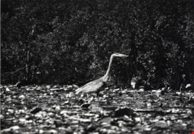
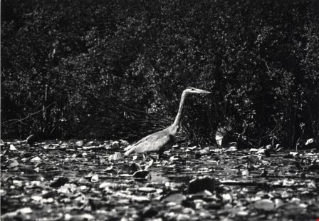
Blue Heron
https://search.heritageburnaby.ca/link/archivedescription79878
- Repository
- City of Burnaby Archives
- Date
- September, 1976
- Collection/Fonds
- Burnaby Public Library Contemporary Visual Archive Project
- Description Level
- Item
- Physical Description
- 1 photograph : b&w ; 11 x 16 cm mounted on cardboard
- Scope and Content
- Photograph shows a blue heron near the shore of Burnaby Lake - one of the more than 180 species of bird and animal life that have been identified in the Burnaby Lake area.
- Repository
- City of Burnaby Archives
- Date
- September, 1976
- Collection/Fonds
- Burnaby Public Library Contemporary Visual Archive Project
- Physical Description
- 1 photograph : b&w ; 11 x 16 cm mounted on cardboard
- Description Level
- Item
- Record No.
- 556-480
- Access Restriction
- No restrictions
- Reproduction Restriction
- Reproduce for fair dealing purposes only
- Accession Number
- 2013-13
- Scope and Content
- Photograph shows a blue heron near the shore of Burnaby Lake - one of the more than 180 species of bird and animal life that have been identified in the Burnaby Lake area.
- Subjects
- Animals - Birds
- Media Type
- Photograph
- Photographer
- Salmon, Stu
- Notes
- Scope note taken directly from BPL photograph description.
- 1 b&w copy negative : 10 x 12.5 cm accompanying
- Geographic Access
- Burnaby Lake
- Historic Neighbourhood
- Burnaby Lake (Historic Neighbourhood)
Images
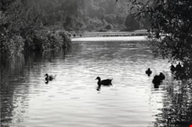
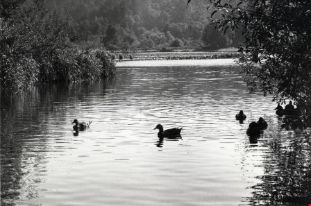
Burnaby Lake
https://search.heritageburnaby.ca/link/archivedescription79877
- Repository
- City of Burnaby Archives
- Date
- September, 1976
- Collection/Fonds
- Burnaby Public Library Contemporary Visual Archive Project
- Description Level
- Item
- Physical Description
- 1 photograph : b&w ; 11 x 16 cm mounted on cardboard
- Scope and Content
- Photograph shows a view of Burnaby Lake with ducks in the foreground.
- Repository
- City of Burnaby Archives
- Date
- September, 1976
- Collection/Fonds
- Burnaby Public Library Contemporary Visual Archive Project
- Physical Description
- 1 photograph : b&w ; 11 x 16 cm mounted on cardboard
- Description Level
- Item
- Record No.
- 556-479
- Access Restriction
- No restrictions
- Reproduction Restriction
- Reproduce for fair dealing purposes only
- Accession Number
- 2013-13
- Scope and Content
- Photograph shows a view of Burnaby Lake with ducks in the foreground.
- Subjects
- Animals - Birds
- Media Type
- Photograph
- Photographer
- Salmon, Stu
- Notes
- Scope note taken directly from BPL photograph description.
- 1 b&w copy negative : 10 x 12.5 cm accompanying
- Geographic Access
- Burnaby Lake
- Historic Neighbourhood
- Burnaby Lake (Historic Neighbourhood)
Images
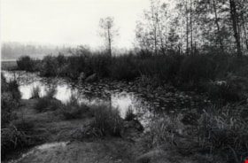
Burnaby Lake
https://search.heritageburnaby.ca/link/archivedescription79879
- Repository
- City of Burnaby Archives
- Date
- September, 1976
- Collection/Fonds
- Burnaby Public Library Contemporary Visual Archive Project
- Description Level
- Item
- Physical Description
- 1 photograph : b&w ; 11 x 16 cm mounted on cardboard
- Scope and Content
- Photograph shows a marshy area on the north side of Burnaby Lake.
- Repository
- City of Burnaby Archives
- Date
- September, 1976
- Collection/Fonds
- Burnaby Public Library Contemporary Visual Archive Project
- Physical Description
- 1 photograph : b&w ; 11 x 16 cm mounted on cardboard
- Description Level
- Item
- Record No.
- 556-481
- Access Restriction
- No restrictions
- Reproduction Restriction
- Reproduce for fair dealing purposes only
- Accession Number
- 2013-13
- Scope and Content
- Photograph shows a marshy area on the north side of Burnaby Lake.
- Media Type
- Photograph
- Photographer
- Campbell, Peg
- Notes
- Scope note taken directly from BPL photograph description.
- 1 b&w copy negative : 10 x 12.5 cm accompanying
- Geographic Access
- Burnaby Lake
- Historic Neighbourhood
- Burnaby Lake (Historic Neighbourhood)
Images

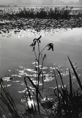
Burnaby Lake
https://search.heritageburnaby.ca/link/archivedescription79880
- Repository
- City of Burnaby Archives
- Date
- September, 1976
- Collection/Fonds
- Burnaby Public Library Contemporary Visual Archive Project
- Description Level
- Item
- Physical Description
- 1 photograph : b&w ; 11 x 16 cm mounted on cardboard
- Scope and Content
- Photograph shows reeds and water lilies on Burnaby Lake.
- Repository
- City of Burnaby Archives
- Date
- September, 1976
- Collection/Fonds
- Burnaby Public Library Contemporary Visual Archive Project
- Physical Description
- 1 photograph : b&w ; 11 x 16 cm mounted on cardboard
- Description Level
- Item
- Record No.
- 556-482
- Access Restriction
- No restrictions
- Reproduction Restriction
- Reproduce for fair dealing purposes only
- Accession Number
- 2013-13
- Scope and Content
- Photograph shows reeds and water lilies on Burnaby Lake.
- Media Type
- Photograph
- Photographer
- McCarron, John
- Notes
- Scope note taken directly from BPL photograph description.
- 1 b&w copy negative : 10 x 12.5 cm accompanying
- Geographic Access
- Burnaby Lake
- Historic Neighbourhood
- Burnaby Lake (Historic Neighbourhood)
Images

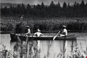
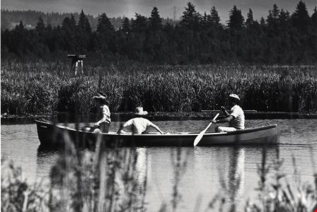
Burnaby Lake
https://search.heritageburnaby.ca/link/archivedescription79882
- Repository
- City of Burnaby Archives
- Date
- September, 1976
- Collection/Fonds
- Burnaby Public Library Contemporary Visual Archive Project
- Description Level
- Item
- Physical Description
- 1 photograph : b&w ; 11 x 16 cm mounted on cardboard
- Scope and Content
- Photograph shows canoeists along the rowing course at the west end of Burnaby Lake.
- Repository
- City of Burnaby Archives
- Date
- September, 1976
- Collection/Fonds
- Burnaby Public Library Contemporary Visual Archive Project
- Physical Description
- 1 photograph : b&w ; 11 x 16 cm mounted on cardboard
- Description Level
- Item
- Record No.
- 556-484
- Access Restriction
- No restrictions
- Reproduction Restriction
- Reproduce for fair dealing purposes only
- Accession Number
- 2013-13
- Scope and Content
- Photograph shows canoeists along the rowing course at the west end of Burnaby Lake.
- Subjects
- Recreational Activities - Canoeing
- Media Type
- Photograph
- Photographer
- Salmon, Stu
- Notes
- Scope note taken directly from BPL photograph description.
- 1 b&w copy negative : 10 x 12.5 cm accompanying
- Geographic Access
- Burnaby Lake
- Historic Neighbourhood
- Burnaby Lake (Historic Neighbourhood)
Images
![Burnaby Lake, [193-] thumbnail](/media/hpo/_Data/_Archives_Images/_Unrestricted/001/072-001.jpg?width=280)
Burnaby Lake
https://search.heritageburnaby.ca/link/archivedescription34637
- Repository
- City of Burnaby Archives
- Date
- [193-]
- Collection/Fonds
- Burnaby Historical Society fonds
- Description Level
- Item
- Physical Description
- 1 photograph : b&w ; 12.7 x 20.3 cm
- Scope and Content
- Aerial photograph of Burnaby Lake and North Burnaby.
- Repository
- City of Burnaby Archives
- Date
- [193-]
- Collection/Fonds
- Burnaby Historical Society fonds
- Subseries
- Photographs subseries
- Physical Description
- 1 photograph : b&w ; 12.7 x 20.3 cm
- Description Level
- Item
- Record No.
- 072-001
- Access Restriction
- No restrictions
- Reproduction Restriction
- No known restrictions
- Accession Number
- BHS2007-04
- Scope and Content
- Aerial photograph of Burnaby Lake and North Burnaby.
- Media Type
- Photograph
- Notes
- Title based on contents of photograph
- Geographic Access
- Burnaby Lake
- Historic Neighbourhood
- Burnaby Lake (Historic Neighbourhood)
- Lozells (Historic Neighbourhood)
- Lochdale (Historic Neighbourhood)
- Planning Study Area
- Parkcrest-Aubrey Area
- Ardingley-Sprott Area
- Burnaby Lake Area
- Government Road Area
- Sperling-Broadway Area
- Lochdale Area
Images
![Burnaby Lake, [193-] thumbnail](/media/hpo/_Data/_Archives_Images/_Unrestricted/001/072-001.jpg)
![Burnaby Lake, [1972] thumbnail](/media/hpo/_Data/_Archives_Images/_Unrestricted/371/389-006.jpg?width=280)
Burnaby Lake
https://search.heritageburnaby.ca/link/archivedescription39793
- Repository
- City of Burnaby Archives
- Date
- [1972]
- Collection/Fonds
- Burnaby Historical Society fonds
- Description Level
- Item
- Physical Description
- 1 photograph : b&w ; 8.7 x 13.3 cm
- Scope and Content
- Photograph taken looking across Burnaby Lake from the Burnaby Lake Rowing Pavilion. The pavilion and other facilities at Burnaby Lake were built in the early 1970s in preparation for the 1973 Canada Summer Games which were co-hosted in 1973 by Burnaby and New Westminster.
- Repository
- City of Burnaby Archives
- Date
- [1972]
- Collection/Fonds
- Burnaby Historical Society fonds
- Subseries
- Photographs subseries
- Physical Description
- 1 photograph : b&w ; 8.7 x 13.3 cm
- Description Level
- Item
- Record No.
- 389-006
- Access Restriction
- No restrictions
- Reproduction Restriction
- Reproduce for fair dealing purposes only
- Accession Number
- BHS2007-04
- Scope and Content
- Photograph taken looking across Burnaby Lake from the Burnaby Lake Rowing Pavilion. The pavilion and other facilities at Burnaby Lake were built in the early 1970s in preparation for the 1973 Canada Summer Games which were co-hosted in 1973 by Burnaby and New Westminster.
- Media Type
- Photograph
- Notes
- Title based on contents of photograph.
- Geographic Access
- Burnaby Lake
- Roberts Street
- Street Address
- 6871 Roberts Street
- Historic Neighbourhood
- Burnaby Lake (Historic Neighbourhood)
- Planning Study Area
- Burnaby Lake Area
Images
![Burnaby Lake, [1972] thumbnail](/media/hpo/_Data/_Archives_Images/_Unrestricted/371/389-006.jpg)
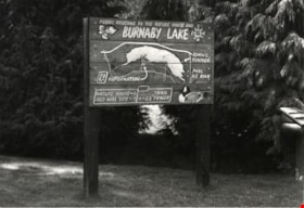
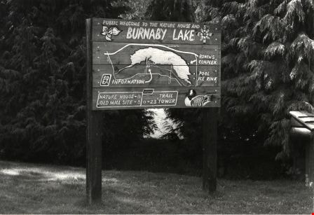
Burnaby Lake Nature House Sign
https://search.heritageburnaby.ca/link/archivedescription79876
- Repository
- City of Burnaby Archives
- Date
- September, 1976
- Collection/Fonds
- Burnaby Public Library Contemporary Visual Archive Project
- Description Level
- Item
- Physical Description
- 1 photograph : b&w ; 11 x 16 cm mounted on cardboard
- Scope and Content
- Photograph shows the sign in front of the nature house in Burnaby Lake showing the locations of the Nature House, the Old Mill Site, the Rowing Complex, the pool, the ice rink and the trail.
- Repository
- City of Burnaby Archives
- Date
- September, 1976
- Collection/Fonds
- Burnaby Public Library Contemporary Visual Archive Project
- Physical Description
- 1 photograph : b&w ; 11 x 16 cm mounted on cardboard
- Description Level
- Item
- Record No.
- 556-478
- Access Restriction
- No restrictions
- Reproduction Restriction
- Reproduce for fair dealing purposes only
- Accession Number
- 2013-13
- Scope and Content
- Photograph shows the sign in front of the nature house in Burnaby Lake showing the locations of the Nature House, the Old Mill Site, the Rowing Complex, the pool, the ice rink and the trail.
- Media Type
- Photograph
- Photographer
- Salmon, Stu
- Notes
- Scope note taken directly from BPL photograph description.
- 1 b&w copy negative : 10 x 12.5 cm accompanying
- Geographic Access
- Burnaby Lake
- Historic Neighbourhood
- Burnaby Lake (Historic Neighbourhood)
Images
![Burnaby Lake Pavilion, [1972] thumbnail](/media/hpo/_Data/_Archives_Images/_Unrestricted/371/389-001.jpg?width=280)
Burnaby Lake Pavilion
https://search.heritageburnaby.ca/link/archivedescription38286
- Repository
- City of Burnaby Archives
- Date
- [1972]
- Collection/Fonds
- Burnaby Historical Society fonds
- Description Level
- Item
- Physical Description
- 1 photograph : sepia ; 8.7 x 13.3 cm
- Scope and Content
- Photograph of the Burnaby Lake Rowing Pavilion under construction. The pavilion and other facilities at Burnaby Lake were built in the early 1970s in preparation for the 1973 Canada Summer Games which were co-hosted in 1973 by Burnaby and New Westminster.
- Repository
- City of Burnaby Archives
- Date
- [1972]
- Collection/Fonds
- Burnaby Historical Society fonds
- Subseries
- Photographs subseries
- Physical Description
- 1 photograph : sepia ; 8.7 x 13.3 cm
- Description Level
- Item
- Record No.
- 389-001
- Access Restriction
- No restrictions
- Reproduction Restriction
- Reproduce for fair dealing purposes only
- Accession Number
- BHS2007-04
- Scope and Content
- Photograph of the Burnaby Lake Rowing Pavilion under construction. The pavilion and other facilities at Burnaby Lake were built in the early 1970s in preparation for the 1973 Canada Summer Games which were co-hosted in 1973 by Burnaby and New Westminster.
- Subjects
- Buildings - Recreational
- Media Type
- Photograph
- Notes
- Title based on contents of photograph.
- Geographic Access
- Burnaby Lake
- Roberts Street
- Street Address
- 6871 Roberts Street
- Historic Neighbourhood
- Burnaby Lake (Historic Neighbourhood)
- Planning Study Area
- Burnaby Lake Area
Images
![Burnaby Lake Pavilion, [1972] thumbnail](/media/hpo/_Data/_Archives_Images/_Unrestricted/371/389-001.jpg)
![Burnaby Lake Pavilion, [1972] thumbnail](/media/hpo/_Data/_Archives_Images/_Unrestricted/371/389-002.jpg?width=280)
Burnaby Lake Pavilion
https://search.heritageburnaby.ca/link/archivedescription39789
- Repository
- City of Burnaby Archives
- Date
- [1972]
- Collection/Fonds
- Burnaby Historical Society fonds
- Description Level
- Item
- Physical Description
- 1 photograph : b&w ; 8.7 x 13.3 cm
- Scope and Content
- Photograph of the Burnaby Lake Rowing Pavilion. The pavilion and other facilities at Burnaby Lake were built in the early 1970s in preparation for the 1973 Canada Summer Games which were co-hosted in 1973 by Burnaby and New Westminster.
- Repository
- City of Burnaby Archives
- Date
- [1972]
- Collection/Fonds
- Burnaby Historical Society fonds
- Subseries
- Photographs subseries
- Physical Description
- 1 photograph : b&w ; 8.7 x 13.3 cm
- Description Level
- Item
- Record No.
- 389-002
- Access Restriction
- No restrictions
- Reproduction Restriction
- Reproduce for fair dealing purposes only
- Accession Number
- BHS2007-04
- Scope and Content
- Photograph of the Burnaby Lake Rowing Pavilion. The pavilion and other facilities at Burnaby Lake were built in the early 1970s in preparation for the 1973 Canada Summer Games which were co-hosted in 1973 by Burnaby and New Westminster.
- Media Type
- Photograph
- Notes
- Title based on contents of photograph.
- Geographic Access
- Burnaby Lake
- Roberts Street
- Street Address
- 6871 Roberts Street
- Historic Neighbourhood
- Burnaby Lake (Historic Neighbourhood)
- Planning Study Area
- Burnaby Lake Area
Images
![Burnaby Lake Pavilion, [1972] thumbnail](/media/hpo/_Data/_Archives_Images/_Unrestricted/371/389-002.jpg)
![Burnaby Lake Pavilion, [1972] thumbnail](/media/hpo/_Data/_Archives_Images/_Unrestricted/371/389-004.jpg?width=280)
Burnaby Lake Pavilion
https://search.heritageburnaby.ca/link/archivedescription39791
- Repository
- City of Burnaby Archives
- Date
- [1972]
- Collection/Fonds
- Burnaby Historical Society fonds
- Description Level
- Item
- Physical Description
- 1 photograph : b&w ; 8.7 x 13.3 cm
- Scope and Content
- Photograph of two people carrying oars up a ramp at the Burnaby Lake Rowing Pavilion. The pavilion and other facilities at Burnaby Lake were built in the early 1970s in preparation for the 1973 Canada Summer Games which were co-hosted in 1973 by Burnaby and New Westminster.
- Repository
- City of Burnaby Archives
- Date
- [1972]
- Collection/Fonds
- Burnaby Historical Society fonds
- Subseries
- Photographs subseries
- Physical Description
- 1 photograph : b&w ; 8.7 x 13.3 cm
- Description Level
- Item
- Record No.
- 389-004
- Access Restriction
- No restrictions
- Reproduction Restriction
- Reproduce for fair dealing purposes only
- Accession Number
- BHS2007-04
- Scope and Content
- Photograph of two people carrying oars up a ramp at the Burnaby Lake Rowing Pavilion. The pavilion and other facilities at Burnaby Lake were built in the early 1970s in preparation for the 1973 Canada Summer Games which were co-hosted in 1973 by Burnaby and New Westminster.
- Subjects
- Buildings - Recreational
- Media Type
- Photograph
- Notes
- Title based on contents of photograph.
- Geographic Access
- Burnaby Lake
- Roberts Street
- Street Address
- 6871 Roberts Street
- Historic Neighbourhood
- Burnaby Lake (Historic Neighbourhood)
- Planning Study Area
- Burnaby Lake Area
Images
![Burnaby Lake Pavilion, [1972] thumbnail](/media/hpo/_Data/_Archives_Images/_Unrestricted/371/389-004.jpg)
![Burnaby Lake Pavilion, [1972] thumbnail](/media/hpo/_Data/_Archives_Images/_Unrestricted/371/389-005.jpg?width=280)
Burnaby Lake Pavilion
https://search.heritageburnaby.ca/link/archivedescription39792
- Repository
- City of Burnaby Archives
- Date
- [1972]
- Collection/Fonds
- Burnaby Historical Society fonds
- Description Level
- Item
- Physical Description
- 1 photograph : b&w ; 8.7 x 13.3 cm
- Scope and Content
- Photograph of an unidentified woman carrying an oar up a ramp at the Burnaby Lake Rowing Pavilion. The pavilion and other facilities at Burnaby Lake were built in the early 1970s in preparation for the 1973 Canada Summer Games which were co-hosted in 1973 by Burnaby and New Westminster.
- Repository
- City of Burnaby Archives
- Date
- [1972]
- Collection/Fonds
- Burnaby Historical Society fonds
- Subseries
- Photographs subseries
- Physical Description
- 1 photograph : b&w ; 8.7 x 13.3 cm
- Description Level
- Item
- Record No.
- 389-005
- Access Restriction
- No restrictions
- Reproduction Restriction
- Reproduce for fair dealing purposes only
- Accession Number
- BHS2007-04
- Scope and Content
- Photograph of an unidentified woman carrying an oar up a ramp at the Burnaby Lake Rowing Pavilion. The pavilion and other facilities at Burnaby Lake were built in the early 1970s in preparation for the 1973 Canada Summer Games which were co-hosted in 1973 by Burnaby and New Westminster.
- Subjects
- Buildings - Recreational
- Media Type
- Photograph
- Notes
- Title based on contents of photograph.
- Geographic Access
- Burnaby Lake
- Roberts Street
- Street Address
- 6871 Roberts Street
- Historic Neighbourhood
- Burnaby Lake (Historic Neighbourhood)
- Planning Study Area
- Burnaby Lake Area
Images
![Burnaby Lake Pavilion, [1972] thumbnail](/media/hpo/_Data/_Archives_Images/_Unrestricted/371/389-005.jpg)
![Burnaby Lake Pavilion entrance, [1972] thumbnail](/media/hpo/_Data/_Archives_Images/_Unrestricted/371/389-003.jpg?width=280)
Burnaby Lake Pavilion entrance
https://search.heritageburnaby.ca/link/archivedescription39790
- Repository
- City of Burnaby Archives
- Date
- [1972]
- Collection/Fonds
- Burnaby Historical Society fonds
- Description Level
- Item
- Physical Description
- 1 photograph : b&w ; 8.7 x 13.3 cm
- Scope and Content
- Photograph of the entrance to the Burnaby Lake Rowing Pavilion. The pavilion and other facilities at Burnaby Lake were built in the early 1970s in preparation for the 1973 Canada Summer Games which were co-hosted in 1973 by Burnaby and New Westminster.
- Repository
- City of Burnaby Archives
- Date
- [1972]
- Collection/Fonds
- Burnaby Historical Society fonds
- Subseries
- Photographs subseries
- Physical Description
- 1 photograph : b&w ; 8.7 x 13.3 cm
- Description Level
- Item
- Record No.
- 389-003
- Access Restriction
- No restrictions
- Reproduction Restriction
- Reproduce for fair dealing purposes only
- Accession Number
- BHS2007-04
- Scope and Content
- Photograph of the entrance to the Burnaby Lake Rowing Pavilion. The pavilion and other facilities at Burnaby Lake were built in the early 1970s in preparation for the 1973 Canada Summer Games which were co-hosted in 1973 by Burnaby and New Westminster.
- Subjects
- Buildings - Recreational
- Media Type
- Photograph
- Notes
- Title based on contents of photograph.
- Geographic Access
- Burnaby Lake
- Roberts Street
- Street Address
- 6871 Roberts Street
- Historic Neighbourhood
- Burnaby Lake (Historic Neighbourhood)
- Planning Study Area
- Burnaby Lake Area
Images
![Burnaby Lake Pavilion entrance, [1972] thumbnail](/media/hpo/_Data/_Archives_Images/_Unrestricted/371/389-003.jpg)

Burnaby Lake rowing course dredging
https://search.heritageburnaby.ca/link/archivedescription38303
- Repository
- City of Burnaby Archives
- Date
- 1971
- Collection/Fonds
- Burnaby Historical Society fonds
- Description Level
- Item
- Physical Description
- 1 photograph : col. ; 12.5 x 18 cm
- Scope and Content
- Aerial photograph of the Burnaby Lake rowing course being dredged in 1971, in preparation for the 1973 Canada Summer Games.
- Repository
- City of Burnaby Archives
- Date
- 1971
- Collection/Fonds
- Burnaby Historical Society fonds
- Subseries
- Photographs subseries
- Physical Description
- 1 photograph : col. ; 12.5 x 18 cm
- Description Level
- Item
- Record No.
- 400-001
- Access Restriction
- No restrictions
- Reproduction Restriction
- Reproduce for fair dealing purposes only
- Accession Number
- BHS2007-04
- Scope and Content
- Aerial photograph of the Burnaby Lake rowing course being dredged in 1971, in preparation for the 1973 Canada Summer Games.
- Media Type
- Photograph
- Notes
- Title based on contents of photograph
- Geographic Access
- Roberts Street
- Burnaby Lake
- Street Address
- 6871 Roberts Street
- Historic Neighbourhood
- Burnaby Lake (Historic Neighbourhood)
- Planning Study Area
- Burnaby Lake Area
Images

Doreen Lawson feeding birds
https://search.heritageburnaby.ca/link/archivedescription91720
- Repository
- City of Burnaby Archives
- Date
- [between 1970 and 1980]
- Collection/Fonds
- Doreen Lawson fonds
- Description Level
- File
- Physical Description
- 3 photographs : b&w & sepia ; 16.5 cm x 23.5 cm
- Scope and Content
- File contains photographs of Doreen Lawson feeding a group of birds on the bank of Burnaby Lake.
- Repository
- City of Burnaby Archives
- Date
- [between 1970 and 1980]
- Collection/Fonds
- Doreen Lawson fonds
- Physical Description
- 3 photographs : b&w & sepia ; 16.5 cm x 23.5 cm
- Description Level
- File
- Record No.
- 605-020
- Access Restriction
- In Archives only
- Reproduction Restriction
- No reproduction permitted
- Accession Number
- 2003-30
- Scope and Content
- File contains photographs of Doreen Lawson feeding a group of birds on the bank of Burnaby Lake.
- Names
- Lawson, Doreen A.
- Media Type
- Photograph
- Photographer
- Diack, George
- Notes
- Title based on contents of photographs
- Stamp on verso of photographs 605-020-2:605-020-3 reads: "Photo by George Diack / Vancouver Sun"
- Sticker on verso of photograph 605-020-1 reads: "Purchase or possession of this print gives no right of duplication, publication or other use without permission from the Vancouver Sun or Province. Contact INFOLINE at [phone]. Fax #: [fax] / 425-015"
- Sticker on verso of photograph 605-020-1 reads: "Copyright - Vancouver Sun / George Diack"
- Geographic Access
- Burnaby Lake
- Historic Neighbourhood
- Burnaby Lake (Historic Neighbourhood)
- Planning Study Area
- Burnaby Lake Area
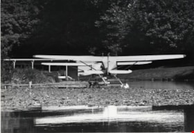
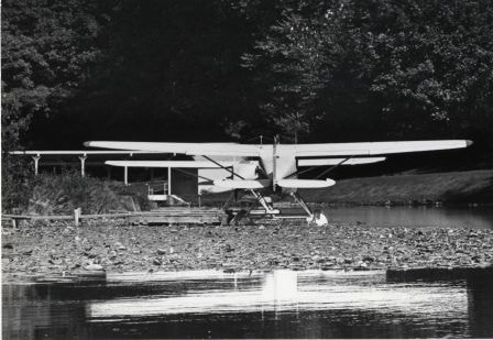
Float Plane
https://search.heritageburnaby.ca/link/archivedescription79883
- Repository
- City of Burnaby Archives
- Date
- September, 1976
- Collection/Fonds
- Burnaby Public Library Contemporary Visual Archive Project
- Description Level
- Item
- Physical Description
- 1 photograph : b&w ; 11 x 16 cm mounted on cardboard
- Scope and Content
- Photograph shows a float plane at the end of the rowing course on Burnaby Lake. Although development of the Lake began in 1963, the rowing course was not built until 1972-1973.
- Repository
- City of Burnaby Archives
- Date
- September, 1976
- Collection/Fonds
- Burnaby Public Library Contemporary Visual Archive Project
- Physical Description
- 1 photograph : b&w ; 11 x 16 cm mounted on cardboard
- Description Level
- Item
- Record No.
- 556-485
- Access Restriction
- No restrictions
- Reproduction Restriction
- Reproduce for fair dealing purposes only
- Accession Number
- 2013-13
- Scope and Content
- Photograph shows a float plane at the end of the rowing course on Burnaby Lake. Although development of the Lake began in 1963, the rowing course was not built until 1972-1973.
- Subjects
- Transportation - Air
- Media Type
- Photograph
- Photographer
- Salmon, Stu
- Notes
- Scope note taken directly from BPL photograph description.
- 1 b&w copy negative : 10 x 12.5 cm accompanying
- Geographic Access
- Burnaby Lake
- Historic Neighbourhood
- Burnaby Lake (Historic Neighbourhood)
Images