Narrow Results By
Improvements to Century Gardens
https://search.heritageburnaby.ca/link/councilreport34282
- Repository
- City of Burnaby Archives
- Report ID
- 30916
- Meeting Date
- 16-Oct-1967
- Format
- Council - Manager's Report
- Manager's Report No.
- 67
- Item No.
- 11
- Collection/Fonds
- City Council and Office of the City Clerk fonds
- Repository
- City of Burnaby Archives
- Report ID
- 30916
- Meeting Date
- 16-Oct-1967
- Format
- Council - Manager's Report
- Manager's Report No.
- 67
- Item No.
- 11
- Collection/Fonds
- City Council and Office of the City Clerk fonds
Documents

Dr. William & Ruth Baldwin House
https://search.heritageburnaby.ca/link/landmark534
- Repository
- Burnaby Heritage Planning
- Description
- The Dr. William & Ruth Baldwin House is a two-storey modern post-and-beam structure, located on the southern shore of Deer Lake in Burnaby's Deer Lake Park. The site is steeply sloped, and the main entrance of the house is at the top of the slope facing onto Deer Lake Drive.
- Associated Dates
- 1965
- Formal Recognition
- Community Heritage Register
- Repository
- Burnaby Heritage Planning
- Geographic Access
- Deer Lake Drive
- Associated Dates
- 1965
- Formal Recognition
- Community Heritage Register
- Enactment Type
- Council Resolution
- Enactment Date
- 26/05/2003
- Description
- The Dr. William & Ruth Baldwin House is a two-storey modern post-and-beam structure, located on the southern shore of Deer Lake in Burnaby's Deer Lake Park. The site is steeply sloped, and the main entrance of the house is at the top of the slope facing onto Deer Lake Drive.
- Heritage Value
- The Baldwin House is valued as a prime example of Burnaby’s post-Second World War modern heritage and progressive architectural style, as well as for its personal connections to internationally-acclaimed architect, Arthur Erickson. Inspired by the modern domestic idiom established earlier in the twentieth century by Frank Lloyd Wright and Richard Neutra, Erickson conceived his architecture as responding directly to the site. A cohesive expression of simple orthogonal lines and ultimate transparency, this structure reduces the idea of post-and-beam West Coast modernism to its most refined elements. A fine example of the evolving talent of Erickson’s earlier work, this house is a landmark modern house in Burnaby and is unique in terms of siting and context. Having just won the 1963 competition for the new Simon Fraser University in Burnaby with his partner, Geoff Massey, and having built fewer than half a dozen homes previously, Erickson’s reputation was growing and his skill as a designer of modern buildings was in great demand. The same year that Erickson/Massey Architects designed SFU, Dr. William Baldwin and his wife, Ruth, personal friends of Erickson, commissioned him to design this house. Erickson was already familiar with the site; as a child he had spent time at this spot when his family visited friends who lived on Deer Lake. Both the Baldwin House and the university were completed in 1965. SFU became internationally famous; the Baldwin House was also considered an architectural success and was recognized in publications of the time. Only a single storey of this two-storey house is visible from the road, as it is built into the hillside in response to its steep site and proximity to Deer Lake. Like many other Erickson designs, this structure was conceived as a pavilion. Constructed of glass and wood, its transparency facilitates visual access to the lake’s edge, acting as an invitation, rather than a barrier, to the landscape. The house blends into the natural surroundings and the site includes other man-made landscape features such as a reflecting pool. As a reaction to the often grey quality of light in the region, Erickson exploits flat planes of water as a source of borrowed light. The refined and purposeful design, transparency, openness of plan and adjacency to the lake combine to give the house a floating appearance at the water's edge. The concept of a floating house set within an accompanying garden was inspired, in part, by the palaces and house boats of Dal Lake in Kashmir and the famed nearby Mughal Gardens. Although Erickson never visited Dal Lake, he travelled extensively throughout India, and specifically mentions the Kashmir reference in relation to this house. There is a rich complexity of other allusions worked into the fabric of the house, unified by a feeling for the conjunction of light, water and land at this special location. Widely renowned as Canada’s most brilliant modern architect, Erickson’s reputation is important to the development and growth of modern architecture in Canada and North America.
- Defining Elements
- The elements of the Baldwin House that define its character are those materials and details which respond to the location of the building and determine the relation between landscape and building, combining to create a single cohesive site. These include its: - close proximity to water - orthogonal plan and massing, with flat tar-and-gravel roof - stepped down massing orienting the house towards the water - post-and-beam construction, with the width of the beams matched to the width of the posts - wood and glass used as primary building materials - transparency and light achieved by the abundant use of glass - large undivided sheets of single glazing - butt glazed glass corners - abundant and generous balconies, which blur the transition from interior to exterior - horizontal flush cedar siding - use of salvaged brick for chimneys - use of chains as downspouts - built-in rooftop barbeque - built in furniture and fittings dating to the time of construction, such as original hardware, benches, bathroom vanities and kitchen cabinets - landscaped site including reflecting pool, plantings and a dock protruding into the lake
- Locality
- Deer Lake Park
- Historic Neighbourhood
- Burnaby Lake (Historic Neighbourhood)
- Planning Study Area
- Morley-Buckingham Area
- Function
- Primary Current--Single Dwelling
- Primary Historic--Single Dwelling
- Community
- Burnaby
- Cadastral Identifier
- P.I.D. No. 011-946-032 and P.I.D. No. 011-946-067
- Boundaries
- The Baldwin House is comprised of two municipally-owned lots located at 6543 and 6545 Deer Lake Drive, Burnaby.
- Area
- 6,070.20
- Contributing Resource
- Building
- Landscape Feature
- Ownership
- Public (local)
- Other Collection
- Canadian Architectural Archives, University of Calgary, Collection: Original Plans No. ERI 4A/76.13
- Documentation
- Heritage Site Files: PC77000 20. City of Burnaby Planning and Building Department, 4949 Canada Way, Burnaby, B.C., V5G 1M2
- Street Address
- 6543 Deer Lake Drive
Images


Fraser Arm Neighbourhood
https://search.heritageburnaby.ca/link/landmark708
- Repository
- Burnaby Heritage Planning
- Associated Dates
- 1925-1954
- Heritage Value
- By the late 1920s, the Fraser Arm Neighbourhood in Burnaby was developing into an industrial and manufacturing district. In 1931, the Canadian National Railway built a bridge over the Fraser River from Burnaby to Lulu Island and advertised that over 30 industries were currently operating along the North Fraser. Along with industries, this district remained an important agricultural area for the Lower Mainland. Chinese market gardens continued to develop and thrive and in 1926, the Vancouver Sun estimated that that Chinese farms in the Lower Fraser Valley then supplied 90 per cent of all green vegetables consumed in the Vancouver market area.
- Historic Neighbourhood
- Fraser Arm (Historic Neighbourhood)
- Planning Study Area
- Big Bend Area
Images


Jubilee Grove Arch
https://search.heritageburnaby.ca/link/landmark533
- Repository
- Burnaby Heritage Planning
- Description
- The Jubilee Grove Arch sits at the corner of Kingsway and Patterson Avenue. Located within Central Park, the ceremonial arch and its decorative plantings provide a visual anchor to the northeast corner and entry point to the park.
- Associated Dates
- 1939
- Formal Recognition
- Heritage Designation, Community Heritage Register
- Street View URL
- Google Maps Street View
- Repository
- Burnaby Heritage Planning
- Geographic Access
- Imperial Street
- Associated Dates
- 1939
- Formal Recognition
- Heritage Designation, Community Heritage Register
- Enactment Type
- Bylaw No. 9807
- Enactment Date
- 23/11/1992
- Description
- The Jubilee Grove Arch sits at the corner of Kingsway and Patterson Avenue. Located within Central Park, the ceremonial arch and its decorative plantings provide a visual anchor to the northeast corner and entry point to the park.
- Heritage Value
- Jubilee Grove Arch was dedicated as part of the municipality’s celebration of the Jubilee of the coronation of King George V and was dedicated during Burnaby’s annual May Day celebrations in 1935. Much of the construction work was carried out by local citizens under the direction of the Burnaby Engineering Department through a Depression era work relief program that provided a way for local residents to pay their taxes. The garden was also chosen as the site for the ceremonial planting of an oak tree from the Royal Forest at Windsor, in honor of the Coronation of King George VI and Queen Elizabeth in 1937. The original bronze garden dedication plaque and oak tree remain at the site today. The decorative stone arch was erected in 1939 as a symbol of Burnaby's, and the Lower Mainland of British Columbia’s, strong ties to the English monarchy at the time, and the arch’s unveiling during May Day ceremonies shows the social role that such a commemorative feature played both to the local government and people of Burnaby. It was erected just prior to the Royal Visit of 1939, the first time that reigning British monarchs had travelled to Canada. Built of Haddington Island sandstone, the arch itself was reconstructed from a salvaged architectural element of a historic Vancouver landmark. The arch originally framed the entrance door to the Vancouver Club building in Vancouver, built in 1893-94 on West Hastings Street and designed by architect C.O. Wickenden. The building was demolished in 1930, however the arch was stored and rebuilt as the focal point of the Jubilee Grove after being bought by the Municipality of Burnaby. The work was undertaken by Italian-born stone mason Rizieri Stefanini (1879-1954), the owner of Burnaby Monumental Works. The re-use of the arch symbolizes the close tie between Vancouver and Burnaby and the joint evolution of the neighbouring cities.
- Defining Elements
- The Jubilee Grove Arch has character-defining elements that recognize it both as a remnant of a past building and as a new and individual structure. These include its: - axial diagonal placement and prominent corner location marking one of the entries to Central Park - visibility and accessibility as a public monument - hand carved stone blocks of Haddington Island sandstone - decorative twisted-rope motif carved to outline the arch - supporting rusticated sidewalls with planting urns - original bronze dedication plaque - flanking ornamental gardens - Royal Oak tree and plaque
- Historic Neighbourhood
- Central Park (Historic Neighbourhood)
- Planning Study Area
- Maywood Area
- Organization
- City of Burnaby
- Architect
- C.O. Wickenden
- Function
- Primary Current--Park Fixture
- Primary Historic--Park Fixture
- Community
- Burnaby
- Cadastral Identifier
- P.I.D. No. 017-767-172 Legal Description: Block B of Lot 2 Except Firstly: Part on Plan 8669 and Secondly: Part on Plan LMP4689 District Lot 151, Group 1, New Westminster District, Plan 3443
- Boundaries
- The property (Central Park) is a municipally-owned park that lies at the western edge of Burnaby, between 49th Avenue to the south, Kingsway to the north, Boundary Road to the west and Patterson Avenue to the east.
- Area
- 853,403.82
- Contributing Resource
- Structure
- Landscape Feature
- Ownership
- Public (local)
- Documentation
- Heritage Site Files: PC77000 20. City of Burnaby Planning and Building Department, 4949 Canada Way, Burnaby, B.C., V5G 1M2
- Names
- Burnaby Monumental Works
- Street Address
- 3883 Imperial Street
- Street View URL
- Google Maps Street View
Images


Lochdale Neighbourhood
https://search.heritageburnaby.ca/link/landmark668
- Repository
- Burnaby Heritage Planning
- Associated Dates
- 1925-1954
- Heritage Value
- In the 1931 "Burnaby Year Book" the Lochdale neighbourhood is described as follows: "Lochdale…is situated at the intersection of the Hastings-Barnet road at the point where Sperling Avenue crosses…Situated at the intersection…there are an up to date service station and a general store, at which the Lochdale Post Office is situated. Immediately north of this is the seventy acres on which the Shell Oil Co. are to build an up-to-date refinery...On going south on Sperling Avenue can be found some lovely homes of the residents, all of which possess the most beautiful flower gardens, some of which are hobbies, and some being in the nature of a business. Others are engaged in chicken farming...while others find employment at the Barnet Mill about two miles east on the Hastings-Barnet Road."
- Historic Neighbourhood
- Lochdale (Historic Neighbourhood)
- Planning Study Area
- Lochdale Area
Images


Willingdon Heights Neighbourhood
https://search.heritageburnaby.ca/link/landmark670
- Repository
- Burnaby Heritage Planning
- Associated Dates
- 1925-1954
- Heritage Value
- Willingdon Heights was another new subdivision developed in Burnaby during the post-World War Two building boom. A brochure about the development published in 1948 proclaimed "the Willingdon Heights 500 home development project in Burnaby fulfills its promise to provide a self-contained community for former members of the armed services and their families...the largest single veteran housing project in Canada as far as homes for individual ownership is concerned, Willingdon Heights development was planned by the Central Mortgage and Housing Corporation...At this date the earlier built rows of homes have passable roads and the owners are improving lawns and gardens in spare time...eventually additional stores and professional services will be installed and recreational projects will add to the amenities of a community of congenial residents..."
- Planning Study Area
- Willingdon Heights Area
Images


Forest Lawn Memorial Park
https://search.heritageburnaby.ca/link/landmark579
- Repository
- Burnaby Heritage Planning
- Description
- Cemetery site.
- Associated Dates
- 1935
- Street View URL
- Google Maps Street View
- Repository
- Burnaby Heritage Planning
- Geographic Access
- Royal Oak Avenue
- Associated Dates
- 1935
- Description
- Cemetery site.
- Heritage Value
- Forest Lawn Memorial Park was founded and designed by Albert F. Arnold, who wanted to design a memorial park “which would be a place of perpetual beauty and which would banish the ‘graveyard’ taint from such places forever.” The 145 acres of Forest Lawn were designed as a garden, which overlooks Vancouver and has a magnificent view of the mountains. Called “God’s Acres,” with white-shelled walks and piped sacred music, the design allowed a natural setting to offer solace to grieve. Bronze memorial plaques were used rather than headstones, which would have marred the garden effect. Arnold acted as a consultant to memorial parks all over Canada and the United States and many of his innovations have become standard practice in North American cemeteries. Equipped with its own greenhouses, the park has more than a million plants of all types. The chapel, which sits on the lower southern slopes, is a sophisticated modernist structure that was designed by renowned local architects McCarter & Nairne.
- Locality
- Burnaby Lake
- Historic Neighbourhood
- Burnaby Lake (Historic Neighbourhood)
- Planning Study Area
- Douglas-Gilpin Area
- Architect
- Albert F. Arnold McCarter & Nairne
- Area
- 449910.00
- Contributing Resource
- Landscape Feature
- Building
- Ownership
- Private
- Street Address
- 3789 Royal Oak Avenue
- Street View URL
- Google Maps Street View
Images

![Forest Lawn Memorial Park buildings and lawns, [1958]. City of Burnaby. Photo ID 067-001. thumbnail](/media/hpo/_Data/_Planning_Images/_Unrestricted/Inventory/BBY-3789-Royal-Oak-Av-1958-Archives%20067-001.jpg)

Garden Village Neighbourhood
https://search.heritageburnaby.ca/link/landmark800
- Repository
- Burnaby Heritage Planning
- Associated Dates
- 1955-2008
- Heritage Value
- Bounded by Moscrop Street to the north, Kingsway and Grange to the south, Willingdon to the east and Boundary Road to the west, the Garden Village Neighbourhood is characterised as a primarily residential area that is well-served due to its proximity to commercial, park and business centres. The north-east corner of the neighbourhood is a typical 1950s subdivision of mostly single family homes located on an irregular street pattern, while the remaining areas saw some transition to multi-family housing types throughout the 1970s and up to the current time.
- Historic Neighbourhood
- Central Park (Historic Neighbourhood)
- Planning Study Area
- Garden Village Area
Images


Central Park Neighbourhood
https://search.heritageburnaby.ca/link/landmark688
- Repository
- Burnaby Heritage Planning
- Associated Dates
- 1925-1954
- Heritage Value
- Although still largely a rural area during the 1920s, subdivisions began appearing in the Central Park neighbourhood at this time. Development was slowed by the Great Depression of the 1930s but the influx of commercial buildings and new housing initiatives in the post-war boom led to a period of rapid growth especially in the Garden Village subdivision which was undertaken in 1953 with the plan to build 500 modern homes in the 140-acre site. Despite the closure of the interurban line in 1953, the neighbourhood remained an active commercial and residential centre.
- Historic Neighbourhood
- Central Park (Historic Neighbourhood)
- Planning Study Area
- Maywood Area
Images


Ocean View Burial Park - Chapel
https://search.heritageburnaby.ca/link/landmark628
- Repository
- Burnaby Heritage Planning
- Geographic Access
- Imperial Street
- Associated Dates
- 1936
- Description
- Church building.
- Heritage Value
- Subsequent work at Ocean View was designed by local architects Sharp & Thompson through the 1950s, including the stone-faced Garden Chapel, built in 1936 as a replica of a Norman church. Prominent stone gates also replaced the original gates at the corner entrance. George Sharp (1880-1974) and Charles Thompson (1878-1961) formed Vancouver’s longest surviving architectural firm in 1908. They were born, educated and articled in London, before arriving in Vancouver via different routes. In 1912, the firm won the competition for the new University of British Columbia.
- Locality
- Alta Vista
- Historic Neighbourhood
- Alta Vista (Historic Neighbourhood)
- Planning Study Area
- Suncrest Area
- Architect
- Sharp & Thompson
- Area
- 359280.00
- Contributing Resource
- Building
- Ownership
- Private
- Street Address
- 4000 Imperial Street
Images

![3700 Block Yale Street, [between 1930 and 1934] (date of original), copied 1991 thumbnail](/media/hpo/_Data/_Archives_Images/_Unrestricted/370/370-139.jpg?width=280)
3700 Block Yale Street
https://search.heritageburnaby.ca/link/archivedescription37551
- Repository
- City of Burnaby Archives
- Date
- [between 1930 and 1934] (date of original), copied 1991
- Collection/Fonds
- Burnaby Historical Society fonds
- Description Level
- Item
- Physical Description
- 1 photograph : b&w ; 2.8 x 4.8 cm print on contact sheet 20.2 x 25.3 cm
- Scope and Content
- Photograph of the 3700 block of Yale Street. At the left is a side view of 515 Esmond Avenue North.
- Repository
- City of Burnaby Archives
- Date
- [between 1930 and 1934] (date of original), copied 1991
- Collection/Fonds
- Burnaby Historical Society fonds
- Subseries
- Burnaby Image Bank subseries
- Physical Description
- 1 photograph : b&w ; 2.8 x 4.8 cm print on contact sheet 20.2 x 25.3 cm
- Description Level
- Item
- Record No.
- 370-139
- Access Restriction
- No restrictions
- Reproduction Restriction
- No known restrictions
- Accession Number
- BHS1999-03
- Scope and Content
- Photograph of the 3700 block of Yale Street. At the left is a side view of 515 Esmond Avenue North.
- Subjects
- Geographic Features - Gardens
- Media Type
- Photograph
- Notes
- Title based on contents of photograph
- 1 b&w copy negative accompanying
- Geographic Access
- Yale Street
- Historic Neighbourhood
- Vancouver Heights (Historic Neighbourhood)
- Planning Study Area
- Burnaby Heights Area
Images
![3700 Block Yale Street, [between 1930 and 1934] (date of original), copied 1991 thumbnail](/media/hpo/_Data/_Archives_Images/_Unrestricted/370/370-139.jpg)
![Bellinger family garden, [1930] (date of original), copied 1991 thumbnail](/media/hpo/_Data/_Archives_Images/_Unrestricted/370/370-053.jpg?width=280)
Bellinger family garden
https://search.heritageburnaby.ca/link/archivedescription37465
- Repository
- City of Burnaby Archives
- Date
- [1930] (date of original), copied 1991
- Collection/Fonds
- Burnaby Historical Society fonds
- Description Level
- Item
- Physical Description
- 1 photograph : b&w ; 3.8 x 2.9 cm print on contact sheet 20.2 x 25.3 cm
- Scope and Content
- Photograph of the Bellinger family back garden at 2827 Earl Avenue (later 6296 Pearl Avenue), with vegetables and a chicken coop at the back right.
- Repository
- City of Burnaby Archives
- Date
- [1930] (date of original), copied 1991
- Collection/Fonds
- Burnaby Historical Society fonds
- Subseries
- Burnaby Image Bank subseries
- Physical Description
- 1 photograph : b&w ; 3.8 x 2.9 cm print on contact sheet 20.2 x 25.3 cm
- Description Level
- Item
- Record No.
- 370-053
- Access Restriction
- No restrictions
- Reproduction Restriction
- No known restrictions
- Accession Number
- BHS1999-03
- Scope and Content
- Photograph of the Bellinger family back garden at 2827 Earl Avenue (later 6296 Pearl Avenue), with vegetables and a chicken coop at the back right.
- Subjects
- Geographic Features - Gardens
- Media Type
- Photograph
- Photographer
- Bellinger, Bernard
- Notes
- Title based on contents of photograph
- 1 b&w copy negative accompanying
- Geographic Access
- Pearl Avenue
- Street Address
- 6296 Pearl Avenue
- Historic Neighbourhood
- Central Park (Historic Neighbourhood)
- Planning Study Area
- Windsor Area
Images
![Bellinger family garden, [1930] (date of original), copied 1991 thumbnail](/media/hpo/_Data/_Archives_Images/_Unrestricted/370/370-053.jpg)
![Blythe Eagles in the garden, [1930] (date of original), copied 1996 thumbnail](/media/hpo/_Data/_Archives_Images/_Unrestricted/316/331-001.jpg?width=280)
Blythe Eagles in the garden
https://search.heritageburnaby.ca/link/archivedescription37183
- Repository
- City of Burnaby Archives
- Date
- [1930] (date of original), copied 1996
- Collection/Fonds
- Burnaby Historical Society fonds
- Description Level
- Item
- Physical Description
- 1 photograph : b&w ; 16.5 x 10 cm print
- Scope and Content
- Photograph of Blythe Eagles with his shirt off, working in the garden.
- Repository
- City of Burnaby Archives
- Date
- [1930] (date of original), copied 1996
- Collection/Fonds
- Burnaby Historical Society fonds
- Subseries
- Eagles family subseries
- Physical Description
- 1 photograph : b&w ; 16.5 x 10 cm print
- Description Level
- Item
- Record No.
- 331-001
- Access Restriction
- No restrictions
- Reproduction Restriction
- No known restrictions
- Accession Number
- BHS1996-21
- Scope and Content
- Photograph of Blythe Eagles with his shirt off, working in the garden.
- Names
- Eagles, Dr. Blythe
- Media Type
- Photograph
- Notes
- Title based on contents of photograph
- Geographic Access
- Sperling Avenue
- Street Address
- 5655 Sperling Avenue
- Historic Neighbourhood
- Burnaby Lake (Historic Neighbourhood)
- Planning Study Area
- Morley-Buckingham Area
Images
![Blythe Eagles in the garden, [1930] (date of original), copied 1996 thumbnail](/media/hpo/_Data/_Archives_Images/_Unrestricted/316/331-001.jpg)
![Blythe Eagles outside his home, [between 1955 and 1960] (date of original), copied 1996 thumbnail](/media/Hpo/_Data/_Archives_Images/_Unrestricted/205/245-002.jpg?width=280)
Blythe Eagles outside his home
https://search.heritageburnaby.ca/link/archivedescription51540
- Repository
- City of Burnaby Archives
- Date
- [between 1955 and 1960] (date of original), copied 1996
- Collection/Fonds
- Burnaby Historical Society fonds
- Description Level
- Item
- Physical Description
- 1 photograph : b&w copy negative ; 4 x 5.5 cm
- Scope and Content
- Photograph of Blythe Eagles standing in front of the Eagles' estate at Deer Lake.
- Repository
- City of Burnaby Archives
- Date
- [between 1955 and 1960] (date of original), copied 1996
- Collection/Fonds
- Burnaby Historical Society fonds
- Subseries
- Eagles family subseries
- Physical Description
- 1 photograph : b&w copy negative ; 4 x 5.5 cm
- Description Level
- Item
- Record No.
- 245-002
- Access Restriction
- No restrictions
- Reproduction Restriction
- Reproduce for fair dealing purposes only
- Accession Number
- BHS1990-11
- Scope and Content
- Photograph of Blythe Eagles standing in front of the Eagles' estate at Deer Lake.
- Names
- Eagles, Dr. Blythe
- Media Type
- Photograph
- Notes
- Title based on contents of photograph
- 1 b&w ; 12.7 x 17.7 cm print accompanying
- Geographic Access
- Sperling Avenue
- Street Address
- 5655 Sperling Avenue
- Historic Neighbourhood
- Burnaby Lake (Historic Neighbourhood)
- Planning Study Area
- Morley-Buckingham Area
Images
![Blythe Eagles outside his home, [between 1955 and 1960] (date of original), copied 1996 thumbnail](/media/Hpo/_Data/_Archives_Images/_Unrestricted/205/245-002.jpg)
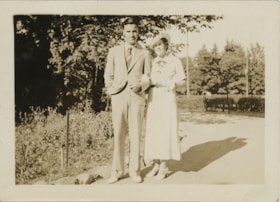
Crichton Hawkshaw and Ruby
https://search.heritageburnaby.ca/link/museumdescription19426
- Repository
- Burnaby Village Museum
- Date
- 1936
- Collection/Fonds
- Hawkshaw family fonds
- Description Level
- Item
- Physical Description
- 1 photograph : sepia ; 6.5 x 9 cm
- Scope and Content
- Photograph of Crichton Hawkshaw and a woman identified as Ruby standing on sidewalk with gardens on either side. Address is identified as 2540 Granville Street Vancouver.
- Repository
- Burnaby Village Museum
- Collection/Fonds
- Hawkshaw family fonds
- Description Level
- Item
- Physical Description
- 1 photograph : sepia ; 6.5 x 9 cm
- Scope and Content
- Photograph of Crichton Hawkshaw and a woman identified as Ruby standing on sidewalk with gardens on either side. Address is identified as 2540 Granville Street Vancouver.
- Subjects
- Geographic Features - Gardens
- Accession Code
- BV996.6.110
- Access Restriction
- No restrictions
- Reproduction Restriction
- No known restrictions
- Date
- 1936
- Media Type
- Photograph
- Scan Resolution
- 600
- Scan Date
- 2023-02-06
- Notes
- Title based on contents of photograph
- Caption beneath photograph reads: "Me 1936"
- Photograph is part of photograph album BV996.6.1
Images
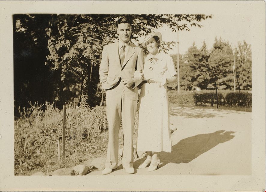

Dot
https://search.heritageburnaby.ca/link/museumdescription2707
- Repository
- Burnaby Village Museum
- Date
- 1937
- Collection/Fonds
- Hawkshaw family fonds
- Description Level
- Item
- Physical Description
- 1 photograph : sepia ; 5.5 x 8 cm
- Scope and Content
- Photograph of Dot standing on the lawn of the R.F. Anderson house located at 3908 Deer Lake Avenue (6504 Deer Lake Avenue) in Burnaby. Mabel Hawkshaw was living in this house in 1937. The Anderson House, gardens and tall trees are visible in the background.
- Repository
- Burnaby Village Museum
- Collection/Fonds
- Hawkshaw family fonds
- Description Level
- Item
- Physical Description
- 1 photograph : sepia ; 5.5 x 8 cm
- Scope and Content
- Photograph of Dot standing on the lawn of the R.F. Anderson house located at 3908 Deer Lake Avenue (6504 Deer Lake Avenue) in Burnaby. Mabel Hawkshaw was living in this house in 1937. The Anderson House, gardens and tall trees are visible in the background.
- Geographic Access
- Deer Lake Avenue
- Accession Code
- BV996.6.139
- Access Restriction
- No restrictions
- Reproduction Restriction
- No known restrictions
- Date
- 1937
- Media Type
- Photograph
- Historic Neighbourhood
- Burnaby Lake (Historic Neighbourhood)
- Planning Study Area
- Morley-Buckingham Area
- Scan Resolution
- 600
- Scan Date
- 2/18/2010
- Scale
- 100
- Notes
- Title based on contents of photograph
- Caption for photograph reads: "Dot + Me"
- Photograph is part of photograph album BV996.6.1
Images
![Eagles Estate Garden, [1935] (date of original), copied 2003 thumbnail](/media/hpo/_Data/_Archives_Images/_Unrestricted/371/455-002.jpg?width=280)
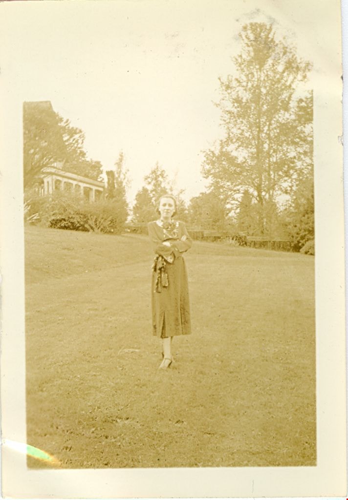
Eagles Estate Garden
https://search.heritageburnaby.ca/link/archivedescription38531
- Repository
- City of Burnaby Archives
- Date
- [1935] (date of original), copied 2003
- Collection/Fonds
- Burnaby Historical Society fonds
- Description Level
- Item
- Physical Description
- 1 photograph : col. ; 10 x 15 cm print
- Scope and Content
- Photograph of a portion of the garden at the Eagles Estate in Deer Lake Park. The property was originally the home of Drs. Blythe and Violet Eagles who cultivated this garden as the centrepiece of their estate.
- Repository
- City of Burnaby Archives
- Date
- [1935] (date of original), copied 2003
- Collection/Fonds
- Burnaby Historical Society fonds
- Subseries
- Municipal record subseries
- Physical Description
- 1 photograph : col. ; 10 x 15 cm print
- Description Level
- Item
- Record No.
- 455-002
- Access Restriction
- No restrictions
- Reproduction Restriction
- No known restrictions
- Accession Number
- BHS2003-9
- Scope and Content
- Photograph of a portion of the garden at the Eagles Estate in Deer Lake Park. The property was originally the home of Drs. Blythe and Violet Eagles who cultivated this garden as the centrepiece of their estate.
- Subjects
- Geographic Features - Gardens
- Media Type
- Photograph
- Notes
- Title based on contents of photograph.
- Geographic Access
- Deer Lake Park
- Sperling Avenue
- Street Address
- 5655 Sperling Avenue
- Historic Neighbourhood
- Burnaby Lake (Historic Neighbourhood)
- Planning Study Area
- Morley-Buckingham Area
Images
![Eagles Estate Garden, [1935] (date of original), copied 2003 thumbnail](/media/hpo/_Data/_Archives_Images/_Unrestricted/371/455-002.jpg)
![Eagles Estate Garden, [1935] (date of original), copied 2003 thumbnail](/media/hpo/_Data/_Archives_Images/_Unrestricted/371/455-003.jpg?width=280)
Eagles Estate Garden
https://search.heritageburnaby.ca/link/archivedescription38532
- Repository
- City of Burnaby Archives
- Date
- [1935] (date of original), copied 2003
- Collection/Fonds
- Burnaby Historical Society fonds
- Description Level
- Item
- Physical Description
- 1 photograph : col. ; 10 x 15 cm print
- Scope and Content
- Photograph of a small section of the garden at the Eagles Estate in Deer Lake park. The property was originally the home of Drs. Blythe and Violet Eagles who cultivated this garden as the centrepiece of their estate.
- Repository
- City of Burnaby Archives
- Date
- [1935] (date of original), copied 2003
- Collection/Fonds
- Burnaby Historical Society fonds
- Subseries
- Municipal record subseries
- Physical Description
- 1 photograph : col. ; 10 x 15 cm print
- Description Level
- Item
- Record No.
- 455-003
- Access Restriction
- No restrictions
- Reproduction Restriction
- No known restrictions
- Accession Number
- BHS2003-9
- Scope and Content
- Photograph of a small section of the garden at the Eagles Estate in Deer Lake park. The property was originally the home of Drs. Blythe and Violet Eagles who cultivated this garden as the centrepiece of their estate.
- Subjects
- Geographic Features - Gardens
- Media Type
- Photograph
- Notes
- Title based on contents of photograph.
- Geographic Access
- Deer Lake Park
- Sperling Avenue
- Street Address
- 5655 Sperling Avenue
- Historic Neighbourhood
- Burnaby Lake (Historic Neighbourhood)
- Planning Study Area
- Morley-Buckingham Area
Images
![Eagles Estate Garden, [1935] (date of original), copied 2003 thumbnail](/media/hpo/_Data/_Archives_Images/_Unrestricted/371/455-003.jpg)
![Eagles Estate Garden, [1935] (date of original), copied 2003 thumbnail](/media/hpo/_Data/_Archives_Images/_Unrestricted/371/455-004.jpg?width=280)
Eagles Estate Garden
https://search.heritageburnaby.ca/link/archivedescription38533
- Repository
- City of Burnaby Archives
- Date
- [1935] (date of original), copied 2003
- Collection/Fonds
- Burnaby Historical Society fonds
- Description Level
- Item
- Physical Description
- 1 photograph : col. ; 10 x 15 cm print
- Scope and Content
- Photograph of a small section of the garden at the Eagles Estate in Deer Lake park. The property was originally the home of Drs. Blythe and Violet Eagles who cultivated this garden as the centrepiece of their estate.
- Repository
- City of Burnaby Archives
- Date
- [1935] (date of original), copied 2003
- Collection/Fonds
- Burnaby Historical Society fonds
- Subseries
- Municipal record subseries
- Physical Description
- 1 photograph : col. ; 10 x 15 cm print
- Description Level
- Item
- Record No.
- 455-004
- Access Restriction
- No restrictions
- Reproduction Restriction
- No known restrictions
- Accession Number
- BHS2003-9
- Scope and Content
- Photograph of a small section of the garden at the Eagles Estate in Deer Lake park. The property was originally the home of Drs. Blythe and Violet Eagles who cultivated this garden as the centrepiece of their estate.
- Subjects
- Geographic Features - Gardens
- Media Type
- Photograph
- Notes
- Title based on contents of photograph.
- Geographic Access
- Deer Lake Park
- Sperling Avenue
- Street Address
- 5655 Sperling Avenue
- Historic Neighbourhood
- Burnaby Lake (Historic Neighbourhood)
- Planning Study Area
- Morley-Buckingham Area
Images
![Eagles Estate Garden, [1935] (date of original), copied 2003 thumbnail](/media/hpo/_Data/_Archives_Images/_Unrestricted/371/455-004.jpg)
![Eagles Estate Garden, [1935] (date of original), copied 2003 thumbnail](/media/hpo/_Data/_Archives_Images/_Unrestricted/371/455-005.jpg?width=280)
Eagles Estate Garden
https://search.heritageburnaby.ca/link/archivedescription38534
- Repository
- City of Burnaby Archives
- Date
- [1935] (date of original), copied 2003
- Collection/Fonds
- Burnaby Historical Society fonds
- Description Level
- Item
- Physical Description
- 1 photograph : col. ; 10 x 15 cm print
- Scope and Content
- Photograph of a small section of the garden at the Eagles Estate in Deer Lake park. The property was originally the home of Drs. Blythe and Violet Eagles who cultivated this garden as the centrepiece of their estate.
- Repository
- City of Burnaby Archives
- Date
- [1935] (date of original), copied 2003
- Collection/Fonds
- Burnaby Historical Society fonds
- Subseries
- Municipal record subseries
- Physical Description
- 1 photograph : col. ; 10 x 15 cm print
- Description Level
- Item
- Record No.
- 455-005
- Access Restriction
- No restrictions
- Reproduction Restriction
- No known restrictions
- Accession Number
- BHS2003-9
- Scope and Content
- Photograph of a small section of the garden at the Eagles Estate in Deer Lake park. The property was originally the home of Drs. Blythe and Violet Eagles who cultivated this garden as the centrepiece of their estate.
- Subjects
- Geographic Features - Gardens
- Media Type
- Photograph
- Notes
- Title based on contents of photograph.
- Geographic Access
- Deer Lake Park
- Sperling Avenue
- Street Address
- 5655 Sperling Avenue
- Historic Neighbourhood
- Burnaby Lake (Historic Neighbourhood)
- Planning Study Area
- Morley-Buckingham Area
Images
![Eagles Estate Garden, [1935] (date of original), copied 2003 thumbnail](/media/hpo/_Data/_Archives_Images/_Unrestricted/371/455-005.jpg)