Narrow Results By
Subject
- Agriculture - Crops 2
- Agriculture - Farms 9
- Animals - Dogs 6
- Animals - Horses 1
- Buildings - Agricultural - Barns 5
- Buildings - Commercial - Stores 2
- Buildings - Heritage 17
- Buildings - Residential 3
- Buildings - Residential - Apartments 1
- Buildings - Residential - Cabins 6
- Buildings - Residential - Houses 128
- Construction 3
![311 Madison Avenue, [1931] (date of original), copied 1991 thumbnail](/media/hpo/_Data/_Archives_Images/_Unrestricted/370/370-203.jpg?width=280)
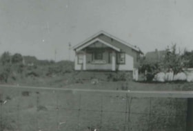
311 Madison Avenue
https://search.heritageburnaby.ca/link/archivedescription37615
- Repository
- City of Burnaby Archives
- Date
- [1931] (date of original), copied 1991
- Collection/Fonds
- Burnaby Historical Society fonds
- Description Level
- Item
- Physical Description
- 1 photograph : b&w ; 3.0 x 4.5 cm print on contact sheet 20.2 x 25.3 cm
- Scope and Content
- Photograph of 311 Madison Avenue; a side view of the house before it was covered in stucco.
- Repository
- City of Burnaby Archives
- Date
- [1931] (date of original), copied 1991
- Collection/Fonds
- Burnaby Historical Society fonds
- Subseries
- Burnaby Image Bank subseries
- Physical Description
- 1 photograph : b&w ; 3.0 x 4.5 cm print on contact sheet 20.2 x 25.3 cm
- Description Level
- Item
- Record No.
- 370-203
- Access Restriction
- No restrictions
- Reproduction Restriction
- No known restrictions
- Accession Number
- BHS1999-03
- Scope and Content
- Photograph of 311 Madison Avenue; a side view of the house before it was covered in stucco.
- Subjects
- Buildings - Residential - Houses
- Media Type
- Photograph
- Notes
- Title based on contents of photograph
- 1 b&w copy negative accompanying
- Geographic Access
- Madison Avenue
- Street Address
- 311 Madison Avenue
- Historic Neighbourhood
- Vancouver Heights (Historic Neighbourhood)
- Planning Study Area
- Burnaby Heights Area
Images
![311 Madison Avenue, [1931] (date of original), copied 1991 thumbnail](/media/hpo/_Data/_Archives_Images/_Unrestricted/370/370-203.jpg)
![515 Esmond Street North, [bewteen 1935 and 1939] (date of original), copied 1991 thumbnail](/media/hpo/_Data/_Archives_Images/_Unrestricted/370/370-132.jpg?width=280)
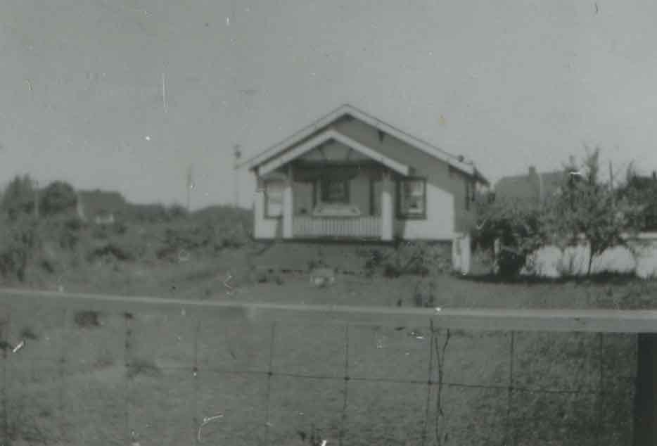
515 Esmond Street North
https://search.heritageburnaby.ca/link/archivedescription37544
- Repository
- City of Burnaby Archives
- Date
- [bewteen 1935 and 1939] (date of original), copied 1991
- Collection/Fonds
- Burnaby Historical Society fonds
- Description Level
- Item
- Physical Description
- 1 photograph : b&w ; 2.8 x 4.3 cm print on contact sheet 20.2 x 25.3 cm
- Scope and Content
- Photograph of 515 Esmond Street North.
- Repository
- City of Burnaby Archives
- Date
- [bewteen 1935 and 1939] (date of original), copied 1991
- Collection/Fonds
- Burnaby Historical Society fonds
- Subseries
- Burnaby Image Bank subseries
- Physical Description
- 1 photograph : b&w ; 2.8 x 4.3 cm print on contact sheet 20.2 x 25.3 cm
- Description Level
- Item
- Record No.
- 370-132
- Access Restriction
- No restrictions
- Reproduction Restriction
- No known restrictions
- Accession Number
- BHS1999-03
- Scope and Content
- Photograph of 515 Esmond Street North.
- Subjects
- Buildings - Residential - Houses
- Media Type
- Photograph
- Notes
- Title based on contents of photograph
- 1 b&w copy negative accompanying
- Photograph copied from a hand-coloured original
- Geographic Access
- Esmond Avenue North
- Street Address
- 515 Esmond Avenue North
- Historic Neighbourhood
- Vancouver Heights (Historic Neighbourhood)
- Planning Study Area
- Burnaby Heights Area
Images
![515 Esmond Street North, [bewteen 1935 and 1939] (date of original), copied 1991 thumbnail](/media/hpo/_Data/_Archives_Images/_Unrestricted/370/370-132.jpg)
![3900 Albert Street - South Side, [196-] thumbnail](/media/hpo/_Data/_Archives_Images/_Unrestricted/316/366-027.jpg?width=280)
3900 Albert Street - South Side
https://search.heritageburnaby.ca/link/archivedescription97610
- Repository
- City of Burnaby Archives
- Date
- [196-]
- Collection/Fonds
- Burnaby Historical Society fonds
- Description Level
- Item
- Physical Description
- 1 photograph : b&w negative
- Scope and Content
- Photograph of two houses on the south corner of Albert Street and Ingleton Avenue at 3900 Albert Street.
- Repository
- City of Burnaby Archives
- Date
- [196-]
- Collection/Fonds
- Burnaby Historical Society fonds
- Subseries
- Municipal record subseries
- Physical Description
- 1 photograph : b&w negative
- Description Level
- Item
- Record No.
- 366-027
- Access Restriction
- No restrictions
- Reproduction Restriction
- Reproduce for fair dealing purposes only
- Accession Number
- BHS1998-12
- Scope and Content
- Photograph of two houses on the south corner of Albert Street and Ingleton Avenue at 3900 Albert Street.
- Subjects
- Buildings - Residential - Houses
- Media Type
- Photograph
- Notes
- Transcribed title
- Note on verso of photograph in black ink reads: "3900 Albert - South Side - Two Houses at East End of Block"
- Geographic Access
- Albert Street
- Street Address
- 3900 Albert Street
- Historic Neighbourhood
- Vancouver Heights (Historic Neighbourhood)
- Planning Study Area
- Burnaby Heights Area
Images
![3900 Albert Street - South Side, [196-] thumbnail](/media/hpo/_Data/_Archives_Images/_Unrestricted/316/366-027.jpg)
![3980 Albert Street, [between 1965 and 1970] thumbnail](/media/hpo/_Data/_Archives_Images/_Unrestricted/316/366-024.jpg?width=280)
3980 Albert Street
https://search.heritageburnaby.ca/link/archivedescription37395
- Repository
- City of Burnaby Archives
- Date
- [between 1965 and 1970]
- Collection/Fonds
- Burnaby Historical Society fonds
- Description Level
- Item
- Physical Description
- 1 photograph : b&w negative
- Scope and Content
- Photograph of the home located at 3980 Albert Street (old street number).
- Repository
- City of Burnaby Archives
- Date
- [between 1965 and 1970]
- Collection/Fonds
- Burnaby Historical Society fonds
- Subseries
- Municipal record subseries
- Physical Description
- 1 photograph : b&w negative
- Description Level
- Item
- Record No.
- 366-024
- Access Restriction
- No restrictions
- Reproduction Restriction
- Reproduce for fair dealing purposes only
- Accession Number
- BHS1998-12
- Scope and Content
- Photograph of the home located at 3980 Albert Street (old street number).
- Subjects
- Buildings - Residential - Houses
- Media Type
- Photograph
- Notes
- Title based on contents of photograph
- Geographic Access
- Albert Street
- Historic Neighbourhood
- Vancouver Heights (Historic Neighbourhood)
- Planning Study Area
- Burnaby Heights Area
Images
![3980 Albert Street, [between 1965 and 1970] thumbnail](/media/hpo/_Data/_Archives_Images/_Unrestricted/316/366-024.jpg)
![3980 Albert Street, [between 1965 and 1970] thumbnail](/media/hpo/_Data/_Archives_Images/_Unrestricted/316/366-025.jpg?width=280)
3980 Albert Street
https://search.heritageburnaby.ca/link/archivedescription37396
- Repository
- City of Burnaby Archives
- Date
- [between 1965 and 1970]
- Collection/Fonds
- Burnaby Historical Society fonds
- Description Level
- Item
- Physical Description
- 1 photograph : b&w negative
- Scope and Content
- Photograph of a house located at 3980 Albert Street (old street number).
- Repository
- City of Burnaby Archives
- Date
- [between 1965 and 1970]
- Collection/Fonds
- Burnaby Historical Society fonds
- Subseries
- Municipal record subseries
- Physical Description
- 1 photograph : b&w negative
- Description Level
- Item
- Record No.
- 366-025
- Access Restriction
- No restrictions
- Reproduction Restriction
- Reproduce for fair dealing purposes only
- Accession Number
- BHS1998-12
- Scope and Content
- Photograph of a house located at 3980 Albert Street (old street number).
- Subjects
- Buildings - Residential - Houses
- Media Type
- Photograph
- Notes
- Title based on contents of photograph
- Geographic Access
- Albert Street
- Historic Neighbourhood
- Vancouver Heights (Historic Neighbourhood)
- Planning Study Area
- Burnaby Heights Area
Images
![3980 Albert Street, [between 1965 and 1970] thumbnail](/media/hpo/_Data/_Archives_Images/_Unrestricted/316/366-025.jpg)
![4042 Yale Street, [1961 or 1962] (date of original), copied 1991 thumbnail](/media/hpo/_Data/_Archives_Images/_Unrestricted/370/370-213.jpg?width=280)
4042 Yale Street
https://search.heritageburnaby.ca/link/archivedescription37625
- Repository
- City of Burnaby Archives
- Date
- [1961 or 1962] (date of original), copied 1991
- Collection/Fonds
- Burnaby Historical Society fonds
- Description Level
- Item
- Physical Description
- 1 photograph : b&w ; 3.9 x 3.9 cm print on contact sheet 20.2 x 25.3 cm
- Scope and Content
- Photograph of 4042 Yale Street, taken from behind and above the house. The photograph was taken facing north, with the north shore mountains visible in the background. The photograph was taken during the winter of 1961 to 1962, and there is snow.
- Repository
- City of Burnaby Archives
- Date
- [1961 or 1962] (date of original), copied 1991
- Collection/Fonds
- Burnaby Historical Society fonds
- Subseries
- Burnaby Image Bank subseries
- Physical Description
- 1 photograph : b&w ; 3.9 x 3.9 cm print on contact sheet 20.2 x 25.3 cm
- Description Level
- Item
- Record No.
- 370-213
- Access Restriction
- No restrictions
- Reproduction Restriction
- No restrictions
- Accession Number
- BHS1999-03
- Scope and Content
- Photograph of 4042 Yale Street, taken from behind and above the house. The photograph was taken facing north, with the north shore mountains visible in the background. The photograph was taken during the winter of 1961 to 1962, and there is snow.
- Media Type
- Photograph
- Notes
- Title based on contents of photograph
- 1 b&w copy negative accompanying
- Geographic Access
- Yale Street
- Street Address
- 4042 Yale Street
- Historic Neighbourhood
- Vancouver Heights (Historic Neighbourhood)
- Planning Study Area
- Burnaby Heights Area
Images
![4042 Yale Street, [1961 or 1962] (date of original), copied 1991 thumbnail](/media/hpo/_Data/_Archives_Images/_Unrestricted/370/370-213.jpg)
![4042 Yale Street, [1961 or 1962] (date of original), copied 1991 thumbnail](/media/hpo/_Data/_Archives_Images/_Unrestricted/370/370-214.jpg?width=280)
4042 Yale Street
https://search.heritageburnaby.ca/link/archivedescription37626
- Repository
- City of Burnaby Archives
- Date
- [1961 or 1962] (date of original), copied 1991
- Collection/Fonds
- Burnaby Historical Society fonds
- Description Level
- Item
- Physical Description
- 1 photograph : b&w ; 3.9 x 3.9 cm print on contact sheet 20.2 x 25.3 cm
- Scope and Content
- Photograph from above 4042 Yale Street looking northeast. Burrard Inlet and the northshore mountains are visible in the background. The photograph was taken during the winter of 1961 to 1962, and there is snow.
- Repository
- City of Burnaby Archives
- Date
- [1961 or 1962] (date of original), copied 1991
- Collection/Fonds
- Burnaby Historical Society fonds
- Subseries
- Burnaby Image Bank subseries
- Physical Description
- 1 photograph : b&w ; 3.9 x 3.9 cm print on contact sheet 20.2 x 25.3 cm
- Description Level
- Item
- Record No.
- 370-214
- Access Restriction
- No restrictions
- Reproduction Restriction
- No restrictions
- Accession Number
- BHS1999-03
- Scope and Content
- Photograph from above 4042 Yale Street looking northeast. Burrard Inlet and the northshore mountains are visible in the background. The photograph was taken during the winter of 1961 to 1962, and there is snow.
- Subjects
- Buildings - Residential - Houses
- Geographic Features - Inlets
- Geographic Features - Mountains
- Media Type
- Photograph
- Notes
- Title based on contents of photograph
- 1 b&w copy negative accompanying
- Geographic Access
- Yale Street
- Street Address
- 4042 Yale Street
- Historic Neighbourhood
- Vancouver Heights (Historic Neighbourhood)
- Planning Study Area
- Burnaby Heights Area
Images
![4042 Yale Street, [1961 or 1962] (date of original), copied 1991 thumbnail](/media/hpo/_Data/_Archives_Images/_Unrestricted/370/370-214.jpg)
![5486 Dominion Street, [between 1960 and 1969] thumbnail](/media/hpo/_Data/_Archives_Images/_Unrestricted/600/620-049.jpg?width=280)
5486 Dominion Street
https://search.heritageburnaby.ca/link/archivedescription91868
- Repository
- City of Burnaby Archives
- Date
- [between 1960 and 1969]
- Collection/Fonds
- Small family fonds
- Description Level
- Item
- Physical Description
- 1 photograph : b&w ; 9 cm x 9.5 cm
- Scope and Content
- Photograph of Frederick Small standing in front of the house at 5486 Dominion Street. Frederick, who married Lauretta Roberts in 1945, purchased the house in 1955 and the Small family moved in.
- Repository
- City of Burnaby Archives
- Date
- [between 1960 and 1969]
- Collection/Fonds
- Small family fonds
- Physical Description
- 1 photograph : b&w ; 9 cm x 9.5 cm
- Description Level
- Item
- Record No.
- 620-049
- Access Restriction
- No restrictions
- Reproduction Restriction
- No reproduction permitted
- Accession Number
- 2017-01
- Scope and Content
- Photograph of Frederick Small standing in front of the house at 5486 Dominion Street. Frederick, who married Lauretta Roberts in 1945, purchased the house in 1955 and the Small family moved in.
- Subjects
- Buildings - Residential - Houses
- Media Type
- Photograph
- Notes
- Transcribed title
- Title transcribed from donor's notes
- Note in blue ink on verso of photograph reads: "P11"
- Frederick Small / Photo - Probably mid 1960's / 5486 Dominion St."
- 5486 Dominion Street later subdivided into two lots: 5480 and 5488 Dominion Street
- Street Address
- 5486 Dominion Street
- Historic Neighbourhood
- Burnaby Lake (Historic Neighbourhood)
- Planning Study Area
- Ardingley-Sprott Area
Images
![5486 Dominion Street, [between 1960 and 1969] thumbnail](/media/hpo/_Data/_Archives_Images/_Unrestricted/600/620-049.jpg)

7342 Curtis Street
https://search.heritageburnaby.ca/link/archivedescription38275
- Repository
- City of Burnaby Archives
- Date
- 1968
- Collection/Fonds
- Burnaby Historical Society fonds
- Description Level
- Item
- Physical Description
- 1 photograph : b&w ; 7 x 9.2 cm
- Scope and Content
- Photograph of a house at 7342 Curtis Street which was a former grocery and butcher shop.
- Repository
- City of Burnaby Archives
- Date
- 1968
- Collection/Fonds
- Burnaby Historical Society fonds
- Subseries
- Photographs subseries
- Physical Description
- 1 photograph : b&w ; 7 x 9.2 cm
- Description Level
- Item
- Record No.
- 382-001
- Access Restriction
- No restrictions
- Reproduction Restriction
- Reproduce for fair dealing purposes only
- Accession Number
- BHS1999-12
- Scope and Content
- Photograph of a house at 7342 Curtis Street which was a former grocery and butcher shop.
- Subjects
- Buildings - Residential - Houses
- Media Type
- Photograph
- Notes
- Title based on caption.
- Geographic Access
- Curtis Street
- Street Address
- 7342 Curtis Street
- Historic Neighbourhood
- Lochdale (Historic Neighbourhood)
- Planning Study Area
- Lochdale Area
Images

![Airplane on a frozen lake, [1932] thumbnail](/media/hpo/_Data/_Archives_Images/_Unrestricted/001/020-169.jpg?width=280)
Airplane on a frozen lake
https://search.heritageburnaby.ca/link/archivedescription34462
- Repository
- City of Burnaby Archives
- Date
- [1932]
- Collection/Fonds
- Burnaby Historical Society fonds
- Description Level
- Item
- Physical Description
- 1 photograph : b&w ; 7 x 12.5 cm on page 17.5 x 26.4 cm
- Scope and Content
- Photograph of an airplane marked "CF-ATA" on a frozen lake near Quesnel. A line of cabins can be seen on the hill in the background.
- Repository
- City of Burnaby Archives
- Date
- [1932]
- Collection/Fonds
- Burnaby Historical Society fonds
- Subseries
- Peers family subseries
- Physical Description
- 1 photograph : b&w ; 7 x 12.5 cm on page 17.5 x 26.4 cm
- Description Level
- Item
- Record No.
- 020-169
- Access Restriction
- No restrictions
- Reproduction Restriction
- No known restrictions
- Accession Number
- BHS2007-04
- Scope and Content
- Photograph of an airplane marked "CF-ATA" on a frozen lake near Quesnel. A line of cabins can be seen on the hill in the background.
- Media Type
- Photograph
- Notes
- Title based on contents of photograph
Images
![Airplane on a frozen lake, [1932] thumbnail](/media/hpo/_Data/_Archives_Images/_Unrestricted/001/020-169.jpg)
![Anderson family home, [1930] (date of original), copied 1986 thumbnail](/media/hpo/_Data/_Archives_Images/_Unrestricted/204/204-034.jpg?width=280)
Anderson family home
https://search.heritageburnaby.ca/link/archivedescription35177
- Repository
- City of Burnaby Archives
- Date
- [1930] (date of original), copied 1986
- Collection/Fonds
- Burnaby Historical Society fonds
- Description Level
- Item
- Physical Description
- 1 photograph : b&w ; 12.7 x 17.8 cm print
- Scope and Content
- Photograph of the Anderson family home at 4127 McGill Street in North Burnaby. The house was built ca. 1923.
- Repository
- City of Burnaby Archives
- Date
- [1930] (date of original), copied 1986
- Collection/Fonds
- Burnaby Historical Society fonds
- Subseries
- Pioneer Tales subseries
- Physical Description
- 1 photograph : b&w ; 12.7 x 17.8 cm print
- Description Level
- Item
- Record No.
- 204-034
- Access Restriction
- No restrictions
- Reproduction Restriction
- No known restrictions
- Accession Number
- BHS1988-03
- Scope and Content
- Photograph of the Anderson family home at 4127 McGill Street in North Burnaby. The house was built ca. 1923.
- Subjects
- Buildings - Residential - Houses
- Media Type
- Photograph
- Notes
- Title based on contents of photograph
- Geographic Access
- McGill Street
- Street Address
- 4127 McGill Street
- Historic Neighbourhood
- Vancouver Heights (Historic Neighbourhood)
- Planning Study Area
- Burnaby Heights Area
Images
![Anderson family home, [1930] (date of original), copied 1986 thumbnail](/media/hpo/_Data/_Archives_Images/_Unrestricted/204/204-034.jpg)

Anderson family home
https://search.heritageburnaby.ca/link/archivedescription37448
- Repository
- City of Burnaby Archives
- Date
- 1962 (date of original), copied 1991
- Collection/Fonds
- Burnaby Historical Society fonds
- Description Level
- Item
- Physical Description
- 1 photograph : b&w ; 4.1 x 3.8 cm print on contact sheet 20.2 x 25.4 cm
- Scope and Content
- Photograph of the front of the Anderson family home at 3908 Norland Avenue (previously numbered 4437 Norland Avenue) in the snow.
- Repository
- City of Burnaby Archives
- Date
- 1962 (date of original), copied 1991
- Collection/Fonds
- Burnaby Historical Society fonds
- Subseries
- Burnaby Image Bank subseries
- Physical Description
- 1 photograph : b&w ; 4.1 x 3.8 cm print on contact sheet 20.2 x 25.4 cm
- Description Level
- Item
- Record No.
- 370-036
- Access Restriction
- No restrictions
- Reproduction Restriction
- No restrictions
- Accession Number
- BHS1999-03
- Scope and Content
- Photograph of the front of the Anderson family home at 3908 Norland Avenue (previously numbered 4437 Norland Avenue) in the snow.
- Media Type
- Photograph
- Notes
- Title based on contents of photograph
- 1 b&w copy negative accompanying
- Geographic Access
- Norland Avenue
- Street Address
- 3908 Norland Avenue
- Historic Neighbourhood
- Burnaby Lake (Historic Neighbourhood)
- Planning Study Area
- Douglas-Gilpin Area
Images

![A.W. MacLeod Cottage, [1935] (date of original), copied 1985 thumbnail](/media/hpo/_Data/_Archives_Images/_Unrestricted/126/152-001.jpg?width=280)
A.W. MacLeod Cottage
https://search.heritageburnaby.ca/link/archivedescription34882
- Repository
- City of Burnaby Archives
- Date
- [1935] (date of original), copied 1985
- Collection/Fonds
- Burnaby Historical Society fonds
- Description Level
- Item
- Physical Description
- 1 photograph : b&w ; 12.2 x 17.4 cm print
- Scope and Content
- Photograph of the A.W. MacLeod cottage at 6466 Deer Lake Drive. An annotation on the back of the photograph describes it as 6450 Deer Lake Drive. An automobile is parked in front of the house.
- Repository
- City of Burnaby Archives
- Date
- [1935] (date of original), copied 1985
- Collection/Fonds
- Burnaby Historical Society fonds
- Subseries
- Photographs subseries
- Physical Description
- 1 photograph : b&w ; 12.2 x 17.4 cm print
- Description Level
- Item
- Record No.
- 152-001
- Access Restriction
- No restrictions
- Reproduction Restriction
- No known restrictions
- Accession Number
- BHS1985-24
- Scope and Content
- Photograph of the A.W. MacLeod cottage at 6466 Deer Lake Drive. An annotation on the back of the photograph describes it as 6450 Deer Lake Drive. An automobile is parked in front of the house.
- Media Type
- Photograph
- Notes
- Title based on contents of photograph
- Geographic Access
- Deer Lake Drive
- Street Address
- 6466 Deer Lake Drive
- Historic Neighbourhood
- Burnaby Lake (Historic Neighbourhood)
- Planning Study Area
- Morley-Buckingham Area
Images
![A.W. MacLeod Cottage, [1935] (date of original), copied 1985 thumbnail](/media/hpo/_Data/_Archives_Images/_Unrestricted/126/152-001.jpg)
![The back of the Wysong House, [1960] thumbnail](/media/hpo/_Data/_Archives_Images/_Unrestricted/251/294-008.jpg?width=280)
The back of the Wysong House
https://search.heritageburnaby.ca/link/archivedescription36554
- Repository
- City of Burnaby Archives
- Date
- [1960]
- Collection/Fonds
- Burnaby Historical Society fonds
- Description Level
- Item
- Physical Description
- 1 photograph : b&w ; 12.5 x 17.5 cm print
- Scope and Content
- Photograph of Mr. Jacobson, the second owner of the "Wysong House" sitting on a bench at the back of the house.
- Repository
- City of Burnaby Archives
- Date
- [1960]
- Collection/Fonds
- Burnaby Historical Society fonds
- Subseries
- Wysong family subseries
- Physical Description
- 1 photograph : b&w ; 12.5 x 17.5 cm print
- Description Level
- Item
- Record No.
- 294-008
- Access Restriction
- No restrictions
- Reproduction Restriction
- Reproduce for fair dealing purposes only
- Accession Number
- BHS1992-32
- Scope and Content
- Photograph of Mr. Jacobson, the second owner of the "Wysong House" sitting on a bench at the back of the house.
- Media Type
- Photograph
- Notes
- Title based on contents of photograph
- Geographic Access
- Sperling Avenue
- Street Address
- 6325 Sperling Avenue
- Historic Neighbourhood
- Edmonds (Historic Neighbourhood)
- Planning Study Area
- Kingsway-Beresford Area
Images
![The back of the Wysong House, [1960] thumbnail](/media/hpo/_Data/_Archives_Images/_Unrestricted/251/294-008.jpg)

Baldwin House, Deer Lake Drive
https://search.heritageburnaby.ca/link/archivedescription37346
- Repository
- City of Burnaby Archives
- Date
- 1966
- Collection/Fonds
- Burnaby Historical Society fonds
- Description Level
- Item
- Physical Description
- 1 photograph ; b&w ; 19.5 x 25 cm print
- Scope and Content
- Photograph of four children (unidentified) playing in the water, in front of the Baldwin House. The Baldwin House was built in 1965 and was designed by architect Arthur Erickson for his friends Dr. William and Ruth Baldwin.
- Repository
- City of Burnaby Archives
- Date
- 1966
- Collection/Fonds
- Burnaby Historical Society fonds
- Subseries
- Baldwin family subseries
- Physical Description
- 1 photograph ; b&w ; 19.5 x 25 cm print
- Description Level
- Item
- Record No.
- 357-001
- Access Restriction
- No restrictions
- Reproduction Restriction
- Reproduce for fair dealing purposes only
- Accession Number
- BHS1998-03
- Scope and Content
- Photograph of four children (unidentified) playing in the water, in front of the Baldwin House. The Baldwin House was built in 1965 and was designed by architect Arthur Erickson for his friends Dr. William and Ruth Baldwin.
- Media Type
- Photograph
- Photographer
- King, Basil
- Notes
- Title based on contents of photograph
- Geographic Access
- Deer Lake Drive
- Deer Lake
- Street Address
- 6543 Deer Lake Drive
- Historic Neighbourhood
- Burnaby Lake (Historic Neighbourhood)
- Planning Study Area
- Morley-Buckingham Area
Images

Banks family home
https://search.heritageburnaby.ca/link/archivedescription37498
- Repository
- City of Burnaby Archives
- Date
- 1933 (date of original), copied 1991
- Collection/Fonds
- Burnaby Historical Society fonds
- Description Level
- Item
- Physical Description
- 1 photograph : b&w ; 2.7 x 4.0 cm print on contact sheet 20.2 x 25.3 cm
- Scope and Content
- Photograph of the Banks family home at the back of the Burnaby Garage at 1812 Britton Street and Kingsway (later renumbered 7383 Britton Street).
- Repository
- City of Burnaby Archives
- Date
- 1933 (date of original), copied 1991
- Collection/Fonds
- Burnaby Historical Society fonds
- Subseries
- Burnaby Image Bank subseries
- Physical Description
- 1 photograph : b&w ; 2.7 x 4.0 cm print on contact sheet 20.2 x 25.3 cm
- Description Level
- Item
- Record No.
- 370-086
- Access Restriction
- No restrictions
- Reproduction Restriction
- No known restrictions
- Accession Number
- BHS1999-03
- Scope and Content
- Photograph of the Banks family home at the back of the Burnaby Garage at 1812 Britton Street and Kingsway (later renumbered 7383 Britton Street).
- Subjects
- Buildings - Residential - Houses
- Names
- Burnaby Garage
- Media Type
- Photograph
- Notes
- Title based on contents of photograph
- 1 b&w copy negative accompanying
- Geographic Access
- Britton Street
- Street Address
- 7383 Britton Street
- Historic Neighbourhood
- Edmonds (Historic Neighbourhood)
- Planning Study Area
- Stride Avenue Area
Images
![Bedroom at 510 Boundary Road, [1930] (date of original), copied ca. 2000 thumbnail](/media/Hpo/_Data/_Archives_Images/_Unrestricted/371/407-012.jpg?width=280)
Bedroom at 510 Boundary Road
https://search.heritageburnaby.ca/link/archivedescription38337
- Repository
- City of Burnaby Archives
- Date
- [1930] (date of original), copied ca. 2000
- Collection/Fonds
- Burnaby Historical Society fonds
- Description Level
- Item
- Physical Description
- 1 photograph : b&w ; 9 x 12.7 cm print
- Scope and Content
- Photograph of a bedroom in house at 510 North Boundary Road.
- Repository
- City of Burnaby Archives
- Date
- [1930] (date of original), copied ca. 2000
- Collection/Fonds
- Burnaby Historical Society fonds
- Subseries
- Photographs subseries
- Physical Description
- 1 photograph : b&w ; 9 x 12.7 cm print
- Description Level
- Item
- Record No.
- 407-012
- Access Restriction
- No restrictions
- Reproduction Restriction
- No known restrictions
- Accession Number
- BHS2007-04
- Scope and Content
- Photograph of a bedroom in house at 510 North Boundary Road.
- Subjects
- Buildings - Residential - Houses
- Media Type
- Photograph
- Notes
- Title based on contents of photograph.
Images
![Bedroom at 510 Boundary Road, [1930] (date of original), copied ca. 2000 thumbnail](/media/Hpo/_Data/_Archives_Images/_Unrestricted/371/407-012.jpg)
![Bellinger and Baker children, [1929 or 1930] (date of original), copied 1991 thumbnail](/media/hpo/_Data/_Archives_Images/_Unrestricted/370/370-063.jpg?width=280)
Bellinger and Baker children
https://search.heritageburnaby.ca/link/archivedescription37475
- Repository
- City of Burnaby Archives
- Date
- [1929 or 1930] (date of original), copied 1991
- Collection/Fonds
- Burnaby Historical Society fonds
- Description Level
- Item
- Physical Description
- 1 photograph : b&w ; 4.4 x 3.0 cm print on contact sheet 20.2 x 25.3 cm
- Scope and Content
- Photograph of five children standing on the board sidewalk in front of 2827 Earl Avenue (later 6296 Pearl Avenue). Left to right: Marion Bellinger, Christine Bellinger, Robert Bellinger, Barbara Baker, and Barbara's sister. Adults are seated on the porch behind them.
- Repository
- City of Burnaby Archives
- Date
- [1929 or 1930] (date of original), copied 1991
- Collection/Fonds
- Burnaby Historical Society fonds
- Subseries
- Burnaby Image Bank subseries
- Physical Description
- 1 photograph : b&w ; 4.4 x 3.0 cm print on contact sheet 20.2 x 25.3 cm
- Description Level
- Item
- Record No.
- 370-063
- Access Restriction
- No restrictions
- Reproduction Restriction
- Reproduce for fair dealing purposes only
- Accession Number
- BHS1999-03
- Scope and Content
- Photograph of five children standing on the board sidewalk in front of 2827 Earl Avenue (later 6296 Pearl Avenue). Left to right: Marion Bellinger, Christine Bellinger, Robert Bellinger, Barbara Baker, and Barbara's sister. Adults are seated on the porch behind them.
- Media Type
- Photograph
- Photographer
- Bellinger, Bernard
- Notes
- Title based on contents of photograph
- 1 b&w copy negative accompanying
- Geographic Access
- Pearl Avenue
- Street Address
- 6296 Pearl Avenue
- Historic Neighbourhood
- Central Park (Historic Neighbourhood)
- Planning Study Area
- Windsor Area
Images
![Bellinger and Baker children, [1929 or 1930] (date of original), copied 1991 thumbnail](/media/hpo/_Data/_Archives_Images/_Unrestricted/370/370-063.jpg)
![Bellinger family home, [1936 or 1937] (date of original), copied 1991 thumbnail](/media/hpo/_Data/_Archives_Images/_Unrestricted/370/370-047.jpg?width=280)
Bellinger family home
https://search.heritageburnaby.ca/link/archivedescription37459
- Repository
- City of Burnaby Archives
- Date
- [1936 or 1937] (date of original), copied 1991
- Collection/Fonds
- Burnaby Historical Society fonds
- Description Level
- Item
- Physical Description
- 1 photograph : b&w ; 4.1 x 2.8 cm print on contact sheet 20.2 x 25.3 cm
- Scope and Content
- Photograph of the Bellinger family home at 2827 Earl Avenue (later 6296 Pearl Avenue), before alterations to the front porch.
- Repository
- City of Burnaby Archives
- Date
- [1936 or 1937] (date of original), copied 1991
- Collection/Fonds
- Burnaby Historical Society fonds
- Subseries
- Burnaby Image Bank subseries
- Physical Description
- 1 photograph : b&w ; 4.1 x 2.8 cm print on contact sheet 20.2 x 25.3 cm
- Description Level
- Item
- Record No.
- 370-047
- Access Restriction
- No restrictions
- Reproduction Restriction
- No known restrictions
- Accession Number
- BHS1999-03
- Scope and Content
- Photograph of the Bellinger family home at 2827 Earl Avenue (later 6296 Pearl Avenue), before alterations to the front porch.
- Subjects
- Buildings - Residential - Houses
- Media Type
- Photograph
- Photographer
- Bellinger, Bernard
- Notes
- Title based on contents of photograph
- 1 b&w copy negative accompanying
- Item no. 370-048 and 370-049 are of house during and after renovations
- Geographic Access
- Pearl Avenue
- Street Address
- 6296 Pearl Avenue
- Historic Neighbourhood
- Central Park (Historic Neighbourhood)
- Planning Study Area
- Windsor Area
Images
![Bellinger family home, [1936 or 1937] (date of original), copied 1991 thumbnail](/media/hpo/_Data/_Archives_Images/_Unrestricted/370/370-047.jpg)
![Bellinger family home, [1936 or 1937] (date of original), copied 1991 thumbnail](/media/hpo/_Data/_Archives_Images/_Unrestricted/370/370-048.jpg?width=280)
Bellinger family home
https://search.heritageburnaby.ca/link/archivedescription37460
- Repository
- City of Burnaby Archives
- Date
- [1936 or 1937] (date of original), copied 1991
- Collection/Fonds
- Burnaby Historical Society fonds
- Description Level
- Item
- Physical Description
- 1 photograph : b&w ; 2.8 x 4.1 cm print on contact sheet 20.2 x 25.3 cm
- Scope and Content
- Photograph of the Bellinger family home at 2827 Earl Avenue (later 6296 Pearl Avenue), during alteration of the front porch. The workers are unidentified.
- Repository
- City of Burnaby Archives
- Date
- [1936 or 1937] (date of original), copied 1991
- Collection/Fonds
- Burnaby Historical Society fonds
- Subseries
- Burnaby Image Bank subseries
- Physical Description
- 1 photograph : b&w ; 2.8 x 4.1 cm print on contact sheet 20.2 x 25.3 cm
- Description Level
- Item
- Record No.
- 370-048
- Access Restriction
- No restrictions
- Reproduction Restriction
- No known restrictions
- Accession Number
- BHS1999-03
- Scope and Content
- Photograph of the Bellinger family home at 2827 Earl Avenue (later 6296 Pearl Avenue), during alteration of the front porch. The workers are unidentified.
- Media Type
- Photograph
- Photographer
- Bellinger, Bernard
- Notes
- Title based on contents of photograph
- 1 b&w copy negative accompanying
- Photos 370-047 and 370-049 show house before and after renovations
- Geographic Access
- Pearl Avenue
- Street Address
- 6296 Pearl Avenue
- Historic Neighbourhood
- Central Park (Historic Neighbourhood)
- Planning Study Area
- Windsor Area
Images
![Bellinger family home, [1936 or 1937] (date of original), copied 1991 thumbnail](/media/hpo/_Data/_Archives_Images/_Unrestricted/370/370-048.jpg)