More like 'Running track at Saint Thomas More Collegiate'
Narrow Results By
Decade
- 2020s 86
- 2010s 41
- 2000s 479
- 1990s 378
- 1980s 370
- 1970s 719
- 1960s
- 1950s 462
- 1940s 419
- 1930s
- 1920s 370
- 1910s 440
- 1900s 173
- 1890s 23
- 1880s 49
- 1870s 3
- 1860s 1
- 1850s 1
- 1840s 1
- 1830s 1
- 1820s 1
- 1810s 1
- 1800s 1
- 1790s 1
- 1780s 1
- 1770s 1
- 1760s 1
- 1750s 1
- 1740s 1
- 1730s 1
- 1720s 1
- 1710s 1
- 1700s 1
- 1690s 1
- 1680s 1
- 1670s 1
- 1660s 1
- 1650s 1
- 1640s 1
- 1630s 1
- 1620s 1
- 1610s 1
- 1600s 1

Duncan & Margaret McGregor Estate 'Glen-Lyon' New Haven Barn
https://search.heritageburnaby.ca/link/landmark852
- Repository
- Burnaby Heritage Planning
- Description
- Designed in a vernacular architectural style, the New Haven Barn is a large gambrel-roofed barn located on the Edwardian era McGregor Estate 'Glen-Lyon,' overlooking the rich farmland of the Fraser River floodplain and near a ravine and forested area adjacent to Marine Drive in South Burnaby.
- Associated Dates
- 1939
- Formal Recognition
- Heritage Designation, Community Heritage Register
- Other Names
- Home of the Friendless, New Haven Borstal Home for Boys and Youthful Offenders, New Haven Correction Centre
- Street View URL
- Google Maps Street View
- Repository
- Burnaby Heritage Planning
- Other Names
- Home of the Friendless, New Haven Borstal Home for Boys and Youthful Offenders, New Haven Correction Centre
- Geographic Access
- Marine Drive
- Associated Dates
- 1939
- Formal Recognition
- Heritage Designation, Community Heritage Register
- Enactment Type
- Bylaw No. 12183
- Enactment Date
- 11/12/2006
- Description
- Designed in a vernacular architectural style, the New Haven Barn is a large gambrel-roofed barn located on the Edwardian era McGregor Estate 'Glen-Lyon,' overlooking the rich farmland of the Fraser River floodplain and near a ravine and forested area adjacent to Marine Drive in South Burnaby.
- Heritage Value
- The site is historically significant for its association with early social welfare and correctional reform. The estate was sold in 1926 to an inter-denominational religious organization called the Home of the Friendless, which used it as their B.C. headquarters. The organization was charged with several cases of abuse and neglect in 1937, after which a Royal Commission was formed that led to new legislation to regulate and license all private welfare institutions. 'Glen-Lyon' was sold to the provincial government, and was dedicated in 1939 by the Lt.-Gov. E.W. Hamber for use as the New Haven Borstal Home for Boys and Youthful Offenders (later renamed the New Haven Correction Centre). The Borstal movement originated in England in the late nineteenth century, as an alternative to sending young offenders and runaways to prisons by providing reformatories that focused on discipline and vocational skill. This site’s role as the first North American institution devoted to the Borstal School philosophy was historic, and influenced corrections programs across Canada. The New Haven Barn is a significant feature from its development in 1939 as the Borstal School, designed by Chief Provincial Architect Henry Whittaker of the Department of Public Works, and is the only remaining structure of its kind in Burnaby.
- Defining Elements
- Key elements that define the heritage character of the New Haven Barn include its: - gambrel-roofed barn with roof vent with finial, sliding hay loft and access doors, small multi-pane windows, and lapped wooden siding
- Historic Neighbourhood
- Fraser Arm (Historic Neighbourhood)
- Planning Study Area
- Big Bend Area
- Architect
- Henry Whittaker
- Function
- Primary Historic--Estate
- Community
- Burnaby
- Cadastral Identifier
- 003-004-661
- Boundaries
- 'Glen-Lyon' is comprised of a single residential lot located at 4250 Marine Drive, Burnaby.
- Area
- 230873.18
- Contributing Resource
- Building
- Ownership
- Private
- Names
- Whittaker, George
- New Haven Borstal Home for Boys and Youthful Offenders
- New Haven Correction Centre
- Borstal School
- Street Address
- 4250 Marine Drive
- Street View URL
- Google Maps Street View
Images


Arrow Neon Sign
https://search.heritageburnaby.ca/link/landmark861
- Repository
- Burnaby Heritage Planning
- Description
- Commercial building.
- Associated Dates
- 1961
- Other Names
- Lost in the 50's Drive-in
- Street View URL
- Google Maps Street View
- Repository
- Burnaby Heritage Planning
- Other Names
- Lost in the 50's Drive-in
- Geographic Access
- Edmonds Street
- Associated Dates
- 1961
- Description
- Commercial building.
- Heritage Value
- The Arrow Neon Sign was built in 1961 by the Neonette Sign Company of New Westminster when this property was opened as the Tomahawk Drive-in Restaurant. The restaurant was later known as Lindy's Burger and in 1990, the business was renamed Lost in the 50's Drive-in. It stands 20-foot tall and is composed of a large double-sided hollow steel panel serpentine arrow mounted on a pole supporting a lexan sign panel measuring approximately 8 feet wide by 4 feet tall. The sign was designed with three illuminated features: a round lamp at the top of the pole, a double-sided rectangular fluorescent sign panel box, and two double-sided rows of orange neon arrows that follow the large serpentine arrow. The Arrow Neon Sign remains as a rare surviving example of neon sign art in the city and is the only historic neon sign in South Burnaby. The sign has gained prominence over the years as it has been associated with this small iconic drive-in which has also been utilized as a set for film production. Additionally, the drive-in has played a prominent role in the Edmonds community as a popular setting for recent "Show and Shine" participants to park their classic cars.
- Locality
- Edmonds
- Historic Neighbourhood
- East Burnaby (Historic Neighbourhood)
- Planning Study Area
- Lakeview-Mayfield Area
- Builder
- Neonette Sign Company
- Community
- Burnaby
- Contributing Resource
- Structure
- Ownership
- Public (local)
- Street Address
- 7741 Edmonds Street
- Street View URL
- Google Maps Street View
Images

![3900 Albert Street, [between 1965 and 1970] thumbnail](/media/hpo/_Data/_Archives_Images/_Unrestricted/316/366-018.jpg?width=280)
3900 Albert Street
https://search.heritageburnaby.ca/link/archivedescription37389
- Repository
- City of Burnaby Archives
- Date
- [between 1965 and 1970]
- Collection/Fonds
- Burnaby Historical Society fonds
- Description Level
- Item
- Physical Description
- 1 photograph : b&w negative
- Scope and Content
- Photograph of the north side of 3900 Albert Street, looking west. The Vancouver Heights Baptist Church can be seen to the far right (at the corner of Albert Street and Ingleton Avenue).
- Repository
- City of Burnaby Archives
- Date
- [between 1965 and 1970]
- Collection/Fonds
- Burnaby Historical Society fonds
- Subseries
- Municipal record subseries
- Physical Description
- 1 photograph : b&w negative
- Description Level
- Item
- Record No.
- 366-018
- Access Restriction
- No restrictions
- Reproduction Restriction
- Reproduce for fair dealing purposes only
- Accession Number
- BHS1998-12
- Scope and Content
- Photograph of the north side of 3900 Albert Street, looking west. The Vancouver Heights Baptist Church can be seen to the far right (at the corner of Albert Street and Ingleton Avenue).
- Media Type
- Photograph
- Notes
- Title based on contents of photograph
- Geographic Access
- Ingleton Avenue
- Albert Street
- Street Address
- 3900 Albert Street
- 271 Ingleton Avenue
- 3977 Albert Street
- Historic Neighbourhood
- Vancouver Heights (Historic Neighbourhood)
- Planning Study Area
- Burnaby Heights Area
Images
![3900 Albert Street, [between 1965 and 1970] thumbnail](/media/hpo/_Data/_Archives_Images/_Unrestricted/316/366-018.jpg)
![3900 Albert Street at Ingleton Avenue, [between 1965 and 1970] thumbnail](/media/hpo/_Data/_Archives_Images/_Unrestricted/316/366-019.jpg?width=280)
3900 Albert Street at Ingleton Avenue
https://search.heritageburnaby.ca/link/archivedescription37390
- Repository
- City of Burnaby Archives
- Date
- [between 1965 and 1970]
- Collection/Fonds
- Burnaby Historical Society fonds
- Description Level
- Item
- Physical Description
- 1 photograph : b&w negative
- Scope and Content
- Photograph looking west along the north side of Albert Street from the 3900 Block. At the far right can be seen the Vancouver Heights Baptist Church, at the intersection of Albert and Ingleton Avenue.
- Repository
- City of Burnaby Archives
- Date
- [between 1965 and 1970]
- Collection/Fonds
- Burnaby Historical Society fonds
- Subseries
- Municipal record subseries
- Physical Description
- 1 photograph : b&w negative
- Description Level
- Item
- Record No.
- 366-019
- Access Restriction
- No restrictions
- Reproduction Restriction
- Reproduce for fair dealing purposes only
- Accession Number
- BHS1998-12
- Scope and Content
- Photograph looking west along the north side of Albert Street from the 3900 Block. At the far right can be seen the Vancouver Heights Baptist Church, at the intersection of Albert and Ingleton Avenue.
- Media Type
- Photograph
- Notes
- Title based on contents of photograph.
- Geographic Access
- Albert Street
- Ingleton Avenue
- Street Address
- 3900 Albert Street
- 271 Ingleton Avenue
- Historic Neighbourhood
- Vancouver Heights (Historic Neighbourhood)
- Planning Study Area
- Burnaby Heights Area
Images
![3900 Albert Street at Ingleton Avenue, [between 1965 and 1970] thumbnail](/media/hpo/_Data/_Archives_Images/_Unrestricted/316/366-019.jpg)
![Front entrance of St. Albans Anglican Church, [1932] thumbnail](/media/hpo/_Data/_Archives_Images/_Unrestricted/477/477-423.jpg?width=280)
Front entrance of St. Albans Anglican Church
https://search.heritageburnaby.ca/link/archivedescription39104
- Repository
- City of Burnaby Archives
- Date
- [1932]
- Collection/Fonds
- Peers Family and Hill Family fonds
- Description Level
- Item
- Physical Description
- 1 photograph : b&w ; 6 x 10 cm on page 17 x 24.5 cm (pasted in album)
- Scope and Content
- Photograph of the front entrance of St. Albans Anglican Church.
- Repository
- City of Burnaby Archives
- Date
- [1932]
- Collection/Fonds
- Peers Family and Hill Family fonds
- Physical Description
- 1 photograph : b&w ; 6 x 10 cm on page 17 x 24.5 cm (pasted in album)
- Description Level
- Item
- Record No.
- 477-423
- Access Restriction
- No restrictions
- Reproduction Restriction
- No known restrictions
- Accession Number
- 2007-12
- Scope and Content
- Photograph of the front entrance of St. Albans Anglican Church.
- Subjects
- Buildings - Religious - Churches
- Media Type
- Photograph
- Notes
- Title based on contents of photograph
- Geographic Access
- 19th Avenue
- Street Address
- 7717 19th Avenue
- Historic Neighbourhood
- Edmonds (Historic Neighbourhood)
- Planning Study Area
- Edmonds Area
Images
![Front entrance of St. Albans Anglican Church, [1932] thumbnail](/media/hpo/_Data/_Archives_Images/_Unrestricted/477/477-423.jpg)
![Burton family home, [1945]. Item no. 216-002 thumbnail](/media/hpo/_Data/_Archives_Images/_Unrestricted/205/216-002.jpg?width=280)
Interview with John Burton by Jim Wolf - Track 3
https://search.heritageburnaby.ca/link/oralhistory226
- Repository
- City of Burnaby Archives
- Date Range
- 1921-1939
- Length
- 0:08:39
- Summary
- This portion of the interview pertains to John Burton's memories of the church events that took place during the depression (community effort). He discusses how the people of East Burnaby survived the depression and also discusses the water problem that occurred in New Westminster in 1921.
- Repository
- City of Burnaby Archives
- Summary
- This portion of the interview pertains to John Burton's memories of the church events that took place during the depression (community effort). He discusses how the people of East Burnaby survived the depression and also discusses the water problem that occurred in New Westminster in 1921.
- Date Range
- 1921-1939
- Photo Info
- Burton family home, [1945]. Item no. 216-002
- Length
- 0:08:39
- Subjects
- Buildings - Religious - Churches
- Scope and Content
- Recording is of an interview with John Burton conducted by Jim Wolf on March 4, 1987 in New Westminster. Major themes include New Westminster businesses and his grandfather's newspaper.
- Biographical Notes
- John Burton was born in 1912 in New Westminster. He went to Second Street School, then Edmonds, then Saint Anne's Convent, and St. Louis College and Connaught before graduating from Burnaby South School in 1930. While at High School, John worked at Cowan's Music Store at 716 Columbia Street in New Westminster on Saturdays and after school. John Burton's grandfather John Foley was the founder of the Orangeville Sun newspaper in Orangeville, Ontario, established in 1861. He ran the paper until his death in 1882, when his son, John Foley Jr. took over as editor and publisher at the age of sixteen. Two of his daughters were involved in the newspaper; Margaret Foley was a regular contributor to the paper, and John Burton's mother was a typesetter. When John Burton was a teenager, he went to Orangeville to learn the trade from his uncle. Unfortunately, he was only there eighteen months when his uncle died December 21, 1932. The family was unable to hold on to the business and the paper amalgamated with the Orangeville Banner newspaper in 1933.
- Total Tracks
- 5
- Total Length
- 0:45:27
- Interviewee Name
- Burton, John
- Collection/Fonds
- Burnaby Historical Society fonds
- Subseries
- Oral history subseries
- Media Type
- Sound Recording
- Web Notes
- Interview was digitized in 2010 allowing it to be accessible on Heritage Burnaby. The digitization project was initiated by the Community Heritage Commission with support from City of Burnaby Council and the BC History Digitization Program of the Irving K. Barber Learning Centre, University of British Columbia. It was recognized by the Heritage Society of BC with an award in 2012.
Images
![Burton family home, [1945]. Item no. 216-002 thumbnail](/media/hpo/_Data/_Archives_Images/_Unrestricted/205/216-002.jpg)
Audio Tracks
Track three of interview with John Burton by Jim Wolf
Track three of interview with John Burton by Jim Wolf
https://search.heritageburnaby.ca/media/hpo/_Data/_Archives_Oral_Histories/_Unrestricted/MSS137-001-5/MSS137-001-5_Track_3.mp3
Old Presbyterian Church
https://search.heritageburnaby.ca/link/archivedescription38245
- Repository
- City of Burnaby Archives
- Date
- 1939
- Collection/Fonds
- Burnaby Historical Society fonds
- Description Level
- Item
- Physical Description
- 1 photograph : b&w ; 9 x 12.5 cm
- Scope and Content
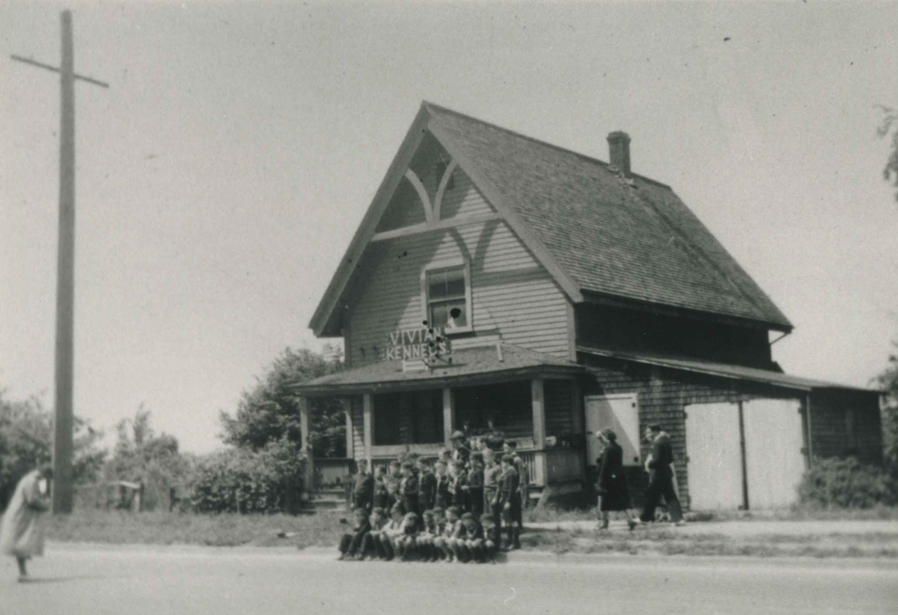
- Photograph of approximately thirty young people posing for a picture on the sidewalk outside what has been labelled the old Presbyterian Church located at Kingsway, east of Boundary Road. A sign on the roof of the building reads "Vivian Kennels."
- Repository
- City of Burnaby Archives
- Date
- 1939
- Collection/Fonds
- Burnaby Historical Society fonds
- Subseries
- Margaret McCallum subseries
- Physical Description
- 1 photograph : b&w ; 9 x 12.5 cm
- Description Level
- Item
- Record No.
- 375-006
- Access Restriction
- No restrictions
- Reproduction Restriction
- No known restrictions
- Accession Number
- BHS1986-42
- Scope and Content
- Photograph of approximately thirty young people posing for a picture on the sidewalk outside what has been labelled the old Presbyterian Church located at Kingsway, east of Boundary Road. A sign on the roof of the building reads "Vivian Kennels."
- Subjects
- Buildings - Religious - Churches
- Media Type
- Photograph
- Notes
- Title based on contents of photograph
- Geographic Access
- Kingsway
- Historic Neighbourhood
- Central Park (Historic Neighbourhood)
- Planning Study Area
- Garden Village Area
Images
![St. Albans, [1932] thumbnail](/media/hpo/_Data/_Archives_Images/_Unrestricted/477/477-425.jpg?width=280)
St. Albans
https://search.heritageburnaby.ca/link/archivedescription39106
- Repository
- City of Burnaby Archives
- Date
- [1932]
- Collection/Fonds
- Peers Family and Hill Family fonds
- Description Level
- Item
- Physical Description
- 1 photograph : b&w ; 6 x 10 cm on page 17 x 24.5 cm (pasted in album)
- Scope and Content
- Photograph of the exterior of St. Albans Anglican church and perimeter fence.
- Repository
- City of Burnaby Archives
- Date
- [1932]
- Collection/Fonds
- Peers Family and Hill Family fonds
- Physical Description
- 1 photograph : b&w ; 6 x 10 cm on page 17 x 24.5 cm (pasted in album)
- Description Level
- Item
- Record No.
- 477-425
- Access Restriction
- No restrictions
- Reproduction Restriction
- No known restrictions
- Accession Number
- 2007-12
- Scope and Content
- Photograph of the exterior of St. Albans Anglican church and perimeter fence.
- Subjects
- Buildings - Religious - Churches
- Media Type
- Photograph
- Notes
- Title based on contents of photograph
- Geographic Access
- 19th Avenue
- Street Address
- 7717 19th Avenue
- Historic Neighbourhood
- Edmonds (Historic Neighbourhood)
- Planning Study Area
- Edmonds Area
Images
![St. Albans, [1932] thumbnail](/media/hpo/_Data/_Archives_Images/_Unrestricted/477/477-425.jpg)
![St. Albans Anglican Church, [1932] thumbnail](/media/hpo/_Data/_Archives_Images/_Unrestricted/477/477-424.jpg?width=280)
St. Albans Anglican Church
https://search.heritageburnaby.ca/link/archivedescription39105
- Repository
- City of Burnaby Archives
- Date
- [1932]
- Collection/Fonds
- Peers Family and Hill Family fonds
- Description Level
- Item
- Physical Description
- 1 photograph : b&w ; 6 x 10 cm on page 17 x 24.5 cm (pasted in album)
- Scope and Content
- Photograph of St. Albans Anglican church, taken from the street. A fence can be seem around the perimeter.
- Repository
- City of Burnaby Archives
- Date
- [1932]
- Collection/Fonds
- Peers Family and Hill Family fonds
- Physical Description
- 1 photograph : b&w ; 6 x 10 cm on page 17 x 24.5 cm (pasted in album)
- Description Level
- Item
- Record No.
- 477-424
- Access Restriction
- No restrictions
- Reproduction Restriction
- No known restrictions
- Accession Number
- 2007-12
- Scope and Content
- Photograph of St. Albans Anglican church, taken from the street. A fence can be seem around the perimeter.
- Subjects
- Buildings - Religious - Churches
- Media Type
- Photograph
- Notes
- Title based on contents of photograph
- Geographic Access
- 19th Avenue
- Street Address
- 7717 19th Avenue
- Historic Neighbourhood
- Edmonds (Historic Neighbourhood)
- Planning Study Area
- Edmonds Area
Images
![St. Albans Anglican Church, [1932] thumbnail](/media/hpo/_Data/_Archives_Images/_Unrestricted/477/477-424.jpg)
![St. Helen's Church, [1930] thumbnail](/media/hpo/_Data/_Archives_Images/_Unrestricted/371/476-014.jpg?width=280)
St. Helen's Church
https://search.heritageburnaby.ca/link/archivedescription38671
- Repository
- City of Burnaby Archives
- Date
- [1930]
- Collection/Fonds
- Burnaby Historical Society fonds
- Description Level
- Item
- Physical Description
- 1 photograph : sepia ; 14.5 x 20.5 cm
- Scope and Content
- Photograph of St. Helen's Church, manse and hall. Two priests can be seen standing on the steps of the manse, both are unidentified.
- Repository
- City of Burnaby Archives
- Date
- [1930]
- Collection/Fonds
- Burnaby Historical Society fonds
- Subseries
- North Burnaby Board of Trade subseries
- Physical Description
- 1 photograph : sepia ; 14.5 x 20.5 cm
- Description Level
- Item
- Record No.
- 476-014
- Access Restriction
- No restrictions
- Reproduction Restriction
- No known restrictions
- Accession Number
- BHS2005-8
- Scope and Content
- Photograph of St. Helen's Church, manse and hall. Two priests can be seen standing on the steps of the manse, both are unidentified.
- Subjects
- Buildings - Religious - Churches
- Media Type
- Photograph
- Notes
- Title based on contents of photograph
- Geographic Access
- Ingleton Avenue
- Triumph Street
- Street Address
- 3894 Triumph Street
- Historic Neighbourhood
- Vancouver Heights (Historic Neighbourhood)
- Planning Study Area
- Burnaby Heights Area
Images
![St. Helen's Church, [1930] thumbnail](/media/hpo/_Data/_Archives_Images/_Unrestricted/371/476-014.jpg)
![St. Nicolas Church, [between 1925 and 1930] thumbnail](/media/hpo/_Data/_Archives_Images/_Unrestricted/371/476-009.jpg?width=280)
St. Nicolas Church
https://search.heritageburnaby.ca/link/archivedescription38666
- Repository
- City of Burnaby Archives
- Date
- [between 1925 and 1930]
- Collection/Fonds
- Burnaby Historical Society fonds
- Description Level
- Item
- Physical Description
- 1 photograph : b&w ; 19.5 x 24.5 cm
- Scope and Content
- Photograph of the interior of St. Nicholas Anglican Church, at the corner of Triumph Street and Ingleton Avenue.
- Repository
- City of Burnaby Archives
- Date
- [between 1925 and 1930]
- Collection/Fonds
- Burnaby Historical Society fonds
- Subseries
- North Burnaby Board of Trade subseries
- Physical Description
- 1 photograph : b&w ; 19.5 x 24.5 cm
- Description Level
- Item
- Record No.
- 476-009
- Access Restriction
- No restrictions
- Reproduction Restriction
- No known restrictions
- Accession Number
- BHS2005-8
- Scope and Content
- Photograph of the interior of St. Nicholas Anglican Church, at the corner of Triumph Street and Ingleton Avenue.
- Subjects
- Buildings - Religious - Churches
- Media Type
- Photograph
- Photographer
- Charlton and Rathburn
- Notes
- Title based on contents of photograph
- Church alternate spelling: "St Nicholas Anglican Church"
- Geographic Access
- Ingleton Avenue
- Triumph Street
- Street Address
- 3883 Triumph Street
- Historic Neighbourhood
- Vancouver Heights (Historic Neighbourhood)
- Planning Study Area
- Burnaby Heights Area
Images
![St. Nicolas Church, [between 1925 and 1930] thumbnail](/media/hpo/_Data/_Archives_Images/_Unrestricted/371/476-009.jpg)
![Sunday School children, [193-] thumbnail](/media/hpo/_Data/_Archives_Images/_Unrestricted/251/269-015.jpg?width=280)
Sunday School children
https://search.heritageburnaby.ca/link/archivedescription53963
- Repository
- City of Burnaby Archives
- Date
- [193-]
- Collection/Fonds
- Burnaby Historical Society fonds
- Description Level
- Item
- Physical Description
- 1 photograph : b&w copy negative ; 35 mm
- Scope and Content
- Photograph of the Riverway Mission Sunday School bus parked outside of the Riverway Mission. The Sunday School children are all standing out in front of the truck, in the front yard.
- Repository
- City of Burnaby Archives
- Date
- [193-]
- Collection/Fonds
- Burnaby Historical Society fonds
- Subseries
- Kay North subseries
- Physical Description
- 1 photograph : b&w copy negative ; 35 mm
- Description Level
- Item
- Record No.
- 269-015
- Access Restriction
- No restrictions
- Reproduction Restriction
- No known restrictions
- Accession Number
- BHS1991-38
- Scope and Content
- Photograph of the Riverway Mission Sunday School bus parked outside of the Riverway Mission. The Sunday School children are all standing out in front of the truck, in the front yard.
- Subjects
- Buildings - Religious - Churches
- Media Type
- Photograph
- Notes
- Title based on contents of photograph
- Geographic Access
- Marine Drive
- Patterson Avenue
- Historic Neighbourhood
- Fraser Arm (Historic Neighbourhood)
- Planning Study Area
- Big Bend Area
Images
![Sunday School children, [193-] thumbnail](/media/hpo/_Data/_Archives_Images/_Unrestricted/251/269-015.jpg)
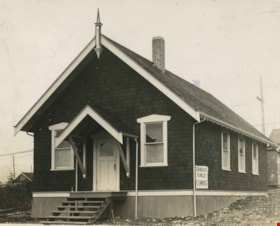
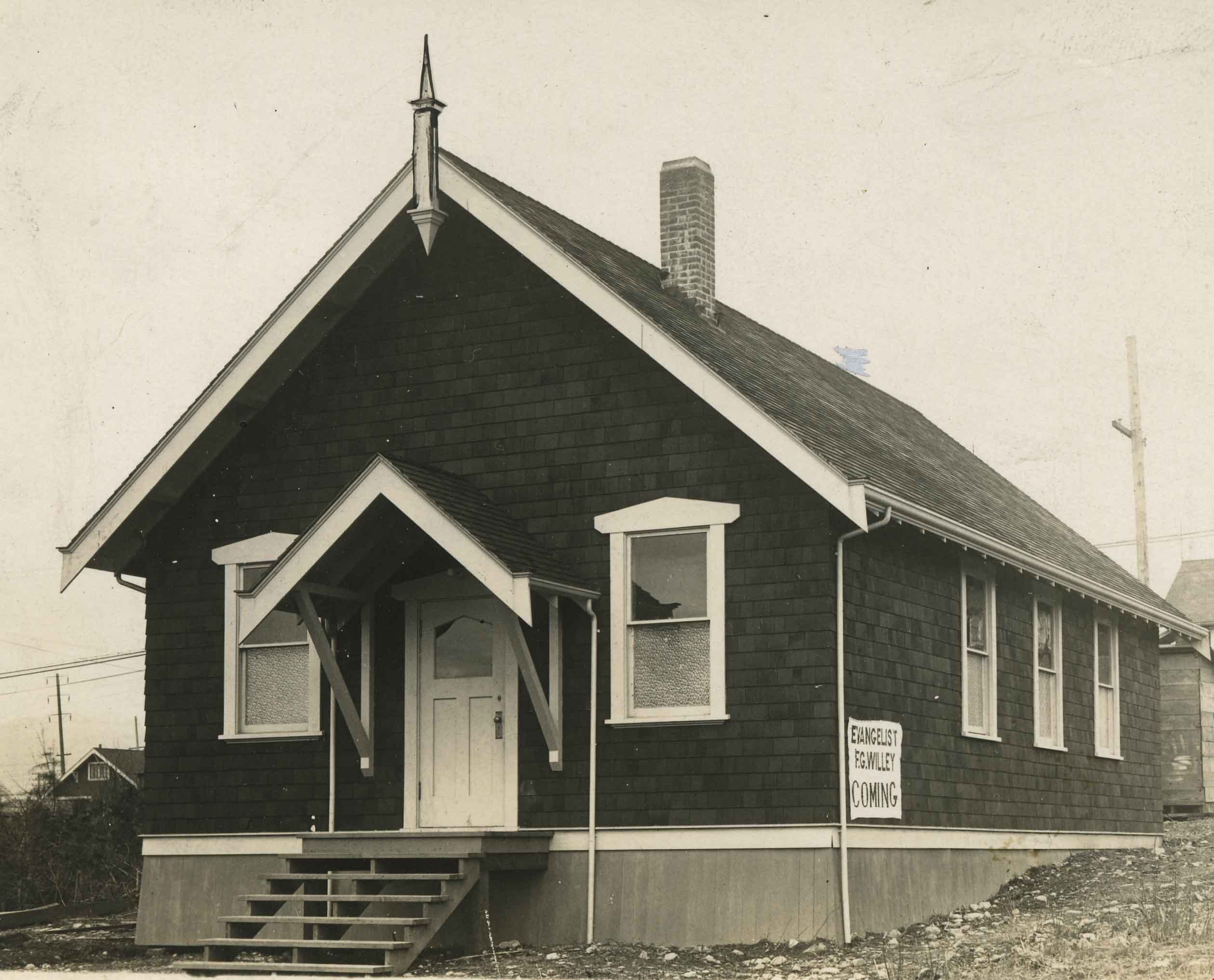
Tabernacle Church
https://search.heritageburnaby.ca/link/archivedescription38676
- Repository
- City of Burnaby Archives
- Date
- 1930
- Collection/Fonds
- Burnaby Historical Society fonds
- Description Level
- Item
- Physical Description
- 1 photograph : b&w postcard ; 9 x 10.8 cm
- Scope and Content
- Photographic postcard of the Union Tabernacle Church at 3891 Georgia Street.
- Repository
- City of Burnaby Archives
- Date
- 1930
- Collection/Fonds
- Burnaby Historical Society fonds
- Subseries
- North Burnaby Board of Trade subseries
- Physical Description
- 1 photograph : b&w postcard ; 9 x 10.8 cm
- Description Level
- Item
- Record No.
- 476-019
- Access Restriction
- No restrictions
- Reproduction Restriction
- No known restrictions
- Accession Number
- BHS2005-8
- Scope and Content
- Photographic postcard of the Union Tabernacle Church at 3891 Georgia Street.
- Names
- Grace Tabernacle Church
- Media Type
- Photograph
- Notes
- Title based on contents of photograph.
- Geographic Access
- Georgia Street
- Historic Neighbourhood
- Vancouver Heights (Historic Neighbourhood)
- Planning Study Area
- Willingdon Heights Area
Images
![Vancouver Heights Church, [Between 1935 and 1945] (date of original), copied 1991 thumbnail](/media/hpo/_Data/_Archives_Images/_Unrestricted/370/370-071.jpg?width=280)
Vancouver Heights Church
https://search.heritageburnaby.ca/link/archivedescription37483
- Repository
- City of Burnaby Archives
- Date
- [Between 1935 and 1945] (date of original), copied 1991
- Collection/Fonds
- Burnaby Historical Society fonds
- Description Level
- Item
- Physical Description
- 1 photograph : b&w ; 3.2 x 5.2 cm print on contact sheet 12.7 x 10.1 cm
- Scope and Content
- Photograph of the Vancouver Heights Church.
- Repository
- City of Burnaby Archives
- Date
- [Between 1935 and 1945] (date of original), copied 1991
- Collection/Fonds
- Burnaby Historical Society fonds
- Subseries
- Burnaby Image Bank subseries
- Physical Description
- 1 photograph : b&w ; 3.2 x 5.2 cm print on contact sheet 12.7 x 10.1 cm
- Description Level
- Item
- Record No.
- 370-071
- Access Restriction
- No restrictions
- Reproduction Restriction
- No known restrictions
- Accession Number
- BHS1999-03
- Scope and Content
- Photograph of the Vancouver Heights Church.
- Subjects
- Buildings - Religious - Churches
- Media Type
- Photograph
- Notes
- Title based on contents of photograph
- 1 b&w copy negative accompanying
- Geographic Access
- Ingleton Avenue
- Street Address
- 271 Ingleton Avenue
- Historic Neighbourhood
- Vancouver Heights (Historic Neighbourhood)
- Planning Study Area
- Burnaby Heights Area
Images
![Vancouver Heights Church, [Between 1935 and 1945] (date of original), copied 1991 thumbnail](/media/hpo/_Data/_Archives_Images/_Unrestricted/370/370-071.jpg)
![Vancouver Heights Church, [between 1930 and 1934] (date of original), copied 1991 thumbnail](/media/hpo/_Data/_Archives_Images/_Unrestricted/370/370-141.jpg?width=280)
Vancouver Heights Church
https://search.heritageburnaby.ca/link/archivedescription37553
- Repository
- City of Burnaby Archives
- Date
- [between 1930 and 1934] (date of original), copied 1991
- Collection/Fonds
- Burnaby Historical Society fonds
- Description Level
- Item
- Physical Description
- 1 photograph : b&w ; 2.9 x 4.7 cm print on contact sheet 20.2 x 25.3 cm
- Scope and Content
- Photograph of Vancouver Heights Church at Ingleton Avenue and Albert Street.
- Repository
- City of Burnaby Archives
- Date
- [between 1930 and 1934] (date of original), copied 1991
- Collection/Fonds
- Burnaby Historical Society fonds
- Subseries
- Burnaby Image Bank subseries
- Physical Description
- 1 photograph : b&w ; 2.9 x 4.7 cm print on contact sheet 20.2 x 25.3 cm
- Description Level
- Item
- Record No.
- 370-141
- Access Restriction
- No restrictions
- Reproduction Restriction
- No known restrictions
- Accession Number
- BHS1999-03
- Scope and Content
- Photograph of Vancouver Heights Church at Ingleton Avenue and Albert Street.
- Subjects
- Buildings - Religious - Churches
- Media Type
- Photograph
- Notes
- Title based on contents of photograph
- 1 b&w copy negative accompanying
- Geographic Access
- Ingleton Avenue
- Street Address
- 271 Ingleton Avenue
- Historic Neighbourhood
- Vancouver Heights (Historic Neighbourhood)
- Planning Study Area
- Burnaby Heights Area
Images
![Vancouver Heights Church, [between 1930 and 1934] (date of original), copied 1991 thumbnail](/media/hpo/_Data/_Archives_Images/_Unrestricted/370/370-141.jpg)
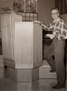
William Myers at St Andrews altar
https://search.heritageburnaby.ca/link/archivedescription88373
- Repository
- City of Burnaby Archives
- Date
- 1961 (date of original)
- Collection/Fonds
- Elaine A. Myers fonds
- Description Level
- Item
- Physical Description
- 1 photograph (jpeg) : sepia ; 96 dpi
- Scope and Content
- Photograph of Elaine's father, William Myers next to the the altar of St. Andrews Church that he built.
- Repository
- City of Burnaby Archives
- Date
- 1961 (date of original)
- Collection/Fonds
- Elaine A. Myers fonds
- Physical Description
- 1 photograph (jpeg) : sepia ; 96 dpi
- Material Details
- Jpeg is a copy created by the donor of a sepia original
- Description Level
- Item
- Record No.
- 580-003
- Access Restriction
- No restrictions
- Reproduction Restriction
- No restrictions
- Accession Number
- 2013-26
- Scope and Content
- Photograph of Elaine's father, William Myers next to the the altar of St. Andrews Church that he built.
- Subjects
- Buildings - Religious - Churches
- Media Type
- Photograph
- Notes
- Title based on contents of photograph
- Geographic Access
- Norfolk Street
- Gilmore Avenue
- Historic Neighbourhood
- Broadview (Historic Neighbourhood)
- Planning Study Area
- Cascade-Schou Area
Images
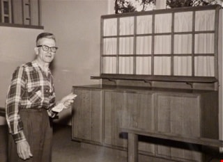

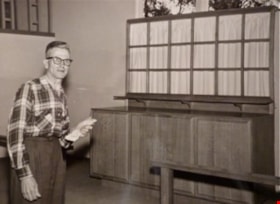
William Myers at St. Andrews pulpit
https://search.heritageburnaby.ca/link/archivedescription88374
- Repository
- City of Burnaby Archives
- Date
- 1961 (date of original)
- Collection/Fonds
- Elaine A. Myers fonds
- Description Level
- Item
- Physical Description
- 1 photograph (jpeg) : sepia ; 96 dpi
- Scope and Content
- Photograph of Elaine's father, William Myers next to the pulpit of St. Andrews Church that he built.
- Repository
- City of Burnaby Archives
- Date
- 1961 (date of original)
- Collection/Fonds
- Elaine A. Myers fonds
- Physical Description
- 1 photograph (jpeg) : sepia ; 96 dpi
- Material Details
- Jpeg is a copy created by the donor of a sepia original
- Description Level
- Item
- Record No.
- 580-004
- Access Restriction
- No restrictions
- Reproduction Restriction
- No restrictions
- Accession Number
- 2013-26
- Scope and Content
- Photograph of Elaine's father, William Myers next to the pulpit of St. Andrews Church that he built.
- Subjects
- Buildings - Religious - Churches
- Media Type
- Photograph
- Notes
- Title based on contents of photograph
- Geographic Access
- Norfolk Street
- Gilmore Avenue
- Historic Neighbourhood
- Broadview (Historic Neighbourhood)
- Planning Study Area
- Cascade-Schou Area
Images
![Chapel at Fairacres, [between 1939 and 1954] thumbnail](/media/hpo/_Data/_Archives_Images/_Unrestricted/205/242-001.jpg?width=280)
Chapel at Fairacres
https://search.heritageburnaby.ca/link/archivedescription36251
- Repository
- City of Burnaby Archives
- Date
- [between 1939 and 1954]
- Collection/Fonds
- Burnaby Historical Society fonds
- Description Level
- Item
- Physical Description
- 1 photograph : b&w copy negative ; 3 x 4 cm
- Scope and Content
- Photograph of the chapel of the Order of St. Benedict at the Ceperley Mansion when they purchased and occupied the mansion from 1939 to 1954. They converted the drawing room into a chapel, placing the altar in front of the fireplace. A platform with a cross on a table. The letters "LOCUS ISTE SANCT…
- Repository
- City of Burnaby Archives
- Date
- [between 1939 and 1954]
- Collection/Fonds
- Burnaby Historical Society fonds
- Subseries
- Burnaby Art Gallery subseries
- Physical Description
- 1 photograph : b&w copy negative ; 3 x 4 cm
- Description Level
- Item
- Record No.
- 242-001
- Access Restriction
- No restrictions
- Reproduction Restriction
- No known restrictions
- Accession Number
- BHS1990-05
- Scope and Content
- Photograph of the chapel of the Order of St. Benedict at the Ceperley Mansion when they purchased and occupied the mansion from 1939 to 1954. They converted the drawing room into a chapel, placing the altar in front of the fireplace. A platform with a cross on a table. The letters "LOCUS ISTE SANCTUS EST" are inscribed on the wall above the cross. There is a picture of baby Jesus held by the Virgin Mary on one side of the platform, and a Saint holding a baby on the other.
- Names
- Westminster Priory
- Media Type
- Photograph
- Notes
- Title based on contents of photograph 1 b&w copy print accompanying
- Geographic Access
- Deer Lake Avenue
- Street Address
- 6344 Deer Lake Avenue
- Historic Neighbourhood
- Burnaby Lake (Historic Neighbourhood)
- Planning Study Area
- Douglas-Gilpin Area
Images
![Chapel at Fairacres, [between 1939 and 1954] thumbnail](/media/hpo/_Data/_Archives_Images/_Unrestricted/205/242-001.jpg)
![Chapel at Fairacres, [between 1939 and 1954] (date of original), copied 1979 thumbnail](/media/hpo/_Data/_BVM_Images/1979/1979_0034_0002_001.jpg?width=280)
Chapel at Fairacres
https://search.heritageburnaby.ca/link/museumdescription1629
- Repository
- Burnaby Village Museum
- Date
- [between 1939 and 1954] (date of original), copied 1979
- Collection/Fonds
- Burnaby Village Museum Photograph collection
- Description Level
- Item
- Physical Description
- 1 photograph : b&w ; 20.3 x 25.2 cm print
- Scope and Content
- Photograph of the chapel of the Order of St. Benedict at the Ceperley Mansion when they purchased and occupied the mansion from 1939 to 1954. They converted the drawing room into a chapel, placing the altar in front of the fireplace. A platform with a cross on a table. The letters "LOCUS ISTE SANCT…
- Repository
- Burnaby Village Museum
- Collection/Fonds
- Burnaby Village Museum Photograph collection
- Description Level
- Item
- Physical Description
- 1 photograph : b&w ; 20.3 x 25.2 cm print
- Scope and Content
- Photograph of the chapel of the Order of St. Benedict at the Ceperley Mansion when they purchased and occupied the mansion from 1939 to 1954. They converted the drawing room into a chapel, placing the altar in front of the fireplace. A platform with a cross on a table. The letters "LOCUS ISTE SANCTUS EST" are inscribed on the wall above the cross. There is a picture of baby Jesus held by the Virgin Mary on one side of the platform, and a Saint holding a baby on the other.
- Names
- Westminster Priory
- Geographic Access
- Deer Lake Avenue
- Street Address
- 6344 Deer Lake Avenue
- Accession Code
- HV979.34.2
- Access Restriction
- Restricted access
- Reproduction Restriction
- May be restricted by third party rights
- Date
- [between 1939 and 1954] (date of original), copied 1979
- Media Type
- Photograph
- Historic Neighbourhood
- Burnaby Lake (Historic Neighbourhood)
- Planning Study Area
- Douglas-Gilpin Area
- Scan Resolution
- 600
- Scan Date
- 2023-09-12
- Notes
- Title based on contents of photograph
Images
![Chapel at Fairacres, [between 1939 and 1954] (date of original), copied 1979 thumbnail](/media/hpo/_Data/_BVM_Images/1979/1979_0034_0002_001.jpg)
![Christ the King Seminary, [1939] (date of original), copied [2001] thumbnail](/media/hpo/_Data/_Archives_Images/_Unrestricted/371/416-003.jpg?width=280)
Christ the King Seminary
https://search.heritageburnaby.ca/link/archivedescription38356
- Repository
- City of Burnaby Archives
- Date
- [1939] (date of original), copied [2001]
- Collection/Fonds
- Burnaby Historical Society fonds
- Description Level
- Item
- Physical Description
- 1 photograph :b&w ; 20.5 x 25.5 cm print
- Scope and Content
- Photograph of the Robert and Bessie Anderson house at Deer Lake, which was built in 1912. In 1939, the house was purchased by the Benedictine Monks for use as part of the Seminary of Christ the King. In 1971, the house was purchased by Burnaby to be used as part of the Arts Centre and, in 1992, wa…
- Repository
- City of Burnaby Archives
- Date
- [1939] (date of original), copied [2001]
- Collection/Fonds
- Burnaby Historical Society fonds
- Subseries
- Municipal record subseries
- Physical Description
- 1 photograph :b&w ; 20.5 x 25.5 cm print
- Description Level
- Item
- Record No.
- 416-003
- Access Restriction
- No restrictions
- Reproduction Restriction
- No known restrictions
- Accession Number
- BHS2001-6
- Scope and Content
- Photograph of the Robert and Bessie Anderson house at Deer Lake, which was built in 1912. In 1939, the house was purchased by the Benedictine Monks for use as part of the Seminary of Christ the King. In 1971, the house was purchased by Burnaby to be used as part of the Arts Centre and, in 1992, was designated as a city heritage site.
- Names
- Christ the King Seminary
- Media Type
- Photograph
- Notes
- Title based on contents of photograph
- Geographic Access
- Deer Lake Avenue
- Historic Neighbourhood
- Burnaby Lake (Historic Neighbourhood)
- Planning Study Area
- Douglas-Gilpin Area
Images
![Christ the King Seminary, [1939] (date of original), copied [2001] thumbnail](/media/hpo/_Data/_Archives_Images/_Unrestricted/371/416-003.jpg)