Narrow Results By
Person / Organization
- Boal, Ethel May Jackson 2
- Boal, Glen 6
- Boal, Thomas "Tom" 2
- Boal, William Ewart 2
- British Columbia Hydro and Power Authority 1
- Burnaby Central Secondary School 1
- Burnaby South High School 1
- Burnaby Symphony Orchestra 1
- Burquest 1
- Canadian Institute of Mining and Metallurgy 1
- Chan, Puy Yuen 5
- City of Burnaby 1

Burnaby Lake Neighbourhood
https://search.heritageburnaby.ca/link/landmark700
- Repository
- Burnaby Heritage Planning
- Associated Dates
- 1925-1954
- Heritage Value
- After World War I and the Great Depression of the 1930s, more homes were constructed and subdivisions created in the Burnaby Lake district. The area around Deer Lake gained a reputation for being an "artistic development of commodious homes with park-like grounds."
- Historic Neighbourhood
- Burnaby Lake (Historic Neighbourhood)
- Planning Study Area
- Burnaby Lake Area
Images


Chapel Of Peace
https://search.heritageburnaby.ca/link/landmark566
- Repository
- Burnaby Heritage Planning
- Description
- Church building.
- Associated Dates
- 1936
- Formal Recognition
- Heritage Designation, Community Heritage Register
- Other Names
- First United Spiritualist Church
- Street View URL
- Google Maps Street View
- Repository
- Burnaby Heritage Planning
- Other Names
- First United Spiritualist Church
- Geographic Access
- Kincaid Street
- Associated Dates
- 1936
- Formal Recognition
- Heritage Designation, Community Heritage Register
- Enactment Type
- Bylaw No. 13162
- Enactment Date
- 28/01/2013
- Description
- Church building.
- Heritage Value
- This church was built in 1936 as the Chapel of Peace for the Forest Lawn Cemetery. It was located outside the main entrance of the cemetery at the triangular parcel of land bounded by Sprott, Royal Oak and Canada Way. It served as the location for many memorial services, local community worship and weddings. The Anglican Church purchased and relocated the building to its present site in 1955. The church has been altered with the addition of wings and stucco, but retains its steep front gabled roof and some of its arched windows. It is now used as the First United Spiritualist Church.
- Locality
- Burnaby Lake
- Historic Neighbourhood
- Burnaby Lake (Historic Neighbourhood)
- Planning Study Area
- Douglas-Gilpin Area
- Contributing Resource
- Building
- Ownership
- Private
- Street Address
- 5584 Kincaid Street
- Street View URL
- Google Maps Street View
Images


Deer Lake Park
https://search.heritageburnaby.ca/link/landmark692
- Repository
- Burnaby Heritage Planning
- Associated Dates
- 1949
- Heritage Value
- As Burnaby developed into a more urban suburb of Vancouver and New Westminster the Deer Lake area retained much of its rural character. In 1949 Deer Lake park was established on the lake's eastern shore. The relocation of the Municipal Hall in the mid-1950s to the Deer Lake area began the vision of developing an administrative and cultural centre for Burnaby. The opportunity for developing this centre began with the opening of the Arts Centre, Century Gardens and the Burnaby Art Gallery in 1967. This was followed by the development of the Deer Lake Park as Burnaby's primary urban park.
- Historic Neighbourhood
- Burnaby Lake (Historic Neighbourhood)
- Planning Study Area
- Morley-Buckingham Area
- Street View URL
- Google Maps Street View
Images


Forest Lawn Memorial Park
https://search.heritageburnaby.ca/link/landmark579
- Repository
- Burnaby Heritage Planning
- Description
- Cemetery site.
- Associated Dates
- 1935
- Street View URL
- Google Maps Street View
- Repository
- Burnaby Heritage Planning
- Geographic Access
- Royal Oak Avenue
- Associated Dates
- 1935
- Description
- Cemetery site.
- Heritage Value
- Forest Lawn Memorial Park was founded and designed by Albert F. Arnold, who wanted to design a memorial park “which would be a place of perpetual beauty and which would banish the ‘graveyard’ taint from such places forever.” The 145 acres of Forest Lawn were designed as a garden, which overlooks Vancouver and has a magnificent view of the mountains. Called “God’s Acres,” with white-shelled walks and piped sacred music, the design allowed a natural setting to offer solace to grieve. Bronze memorial plaques were used rather than headstones, which would have marred the garden effect. Arnold acted as a consultant to memorial parks all over Canada and the United States and many of his innovations have become standard practice in North American cemeteries. Equipped with its own greenhouses, the park has more than a million plants of all types. The chapel, which sits on the lower southern slopes, is a sophisticated modernist structure that was designed by renowned local architects McCarter & Nairne.
- Locality
- Burnaby Lake
- Historic Neighbourhood
- Burnaby Lake (Historic Neighbourhood)
- Planning Study Area
- Douglas-Gilpin Area
- Architect
- Albert F. Arnold McCarter & Nairne
- Area
- 449910.00
- Contributing Resource
- Landscape Feature
- Building
- Ownership
- Private
- Street Address
- 3789 Royal Oak Avenue
- Street View URL
- Google Maps Street View
Images

![Forest Lawn Memorial Park buildings and lawns, [1958]. City of Burnaby. Photo ID 067-001. thumbnail](/media/hpo/_Data/_Planning_Images/_Unrestricted/Inventory/BBY-3789-Royal-Oak-Av-1958-Archives%20067-001.jpg)

Hans & Anna Hau Residence
https://search.heritageburnaby.ca/link/landmark588
- Repository
- Burnaby Heritage Planning
- Description
- Residential building.
- Associated Dates
- c.1935
- Street View URL
- Google Maps Street View
- Repository
- Burnaby Heritage Planning
- Geographic Access
- Canada Way
- Associated Dates
- c.1935
- Description
- Residential building.
- Heritage Value
- Danish builder Hans Jorgensen Hau (1878-1944) and his wife Anna (née Sorenson, 1874-1956), constructed this highly-distinctive Tudor Revival residence circa 1935. This was a time of entrenched traditionalism, and most domestic architecture reflected period revival styles. Tudor elements have been compressed here into a cottage form, including a distinctive front façade with half timbering and brick noggin; on the sides the nogging is rock-dash stucco. Casement windows contribute to the cottage appearance. The rear façade is clad with more utilitarian shingles. A prominent brick chimney exhibits angled and corbelled brickwork. Hau worked as a bricklayer and stonemason, and this house has common elements with the Moore Residence at 5165 Sperling Avenue, which Hau designed and constructed in 1943.
- Locality
- Burnaby Lake
- Historic Neighbourhood
- Burnaby Lake (Historic Neighbourhood)
- Planning Study Area
- Morley-Buckingham Area
- Area
- 2010.52
- Contributing Resource
- Building
- Ownership
- Private
- Street Address
- 5070 Canada Way
- Street View URL
- Google Maps Street View
Images


Montague & Marcia Moore Residence
https://search.heritageburnaby.ca/link/landmark499
- Repository
- Burnaby Heritage Planning
- Description
- The Montague and Marcia Moore Residence, situated on Sperling Avenue, is a one and one-half storey wood-frame house with Tudor Revival elements such as half-timbering and diamond-leaded windows. The landscaping includes a large hedge at the front of the property. It is located on a lakefront site w…
- Associated Dates
- 1943
- Street View URL
- Google Maps Street View
- Repository
- Burnaby Heritage Planning
- Geographic Access
- Sperling Avenue
- Associated Dates
- 1943
- Description
- The Montague and Marcia Moore Residence, situated on Sperling Avenue, is a one and one-half storey wood-frame house with Tudor Revival elements such as half-timbering and diamond-leaded windows. The landscaping includes a large hedge at the front of the property. It is located on a lakefront site within the scenic Deer Lake Park Heritage Precinct.
- Heritage Value
- Located within the historic Deer Lake Park neighbourhood, the Montague and Marcia Moore Residence is valued as an example of the late persistence of the historicist influence on domestic architecture, at a time when it was still considered the height of good taste for a house to be designed in a recognizable period revival style. This is reflected in the rustic Tudor Revival elements such as half-timbering, waney-edged boards in the gables, brick nogging, diamond-leaded windows, and bird houses in the main gable. The cobblestone chimney, the major focal point of the house, was constructed from river stones that were transported from Lynn Canyon. Meticulously retained in its original condition, this was the last home to be constructed by the Moore family before the Second World War construction supply rationing took effect. It was built by Danish contractor, Hans Jorgensen Hau (1878-1944), who had a flair for the construction of homes with a rustic character, and shares a number of design features with Hau’s own house at 5070 Canada Way.
- Defining Elements
- Key elements that define the heritage character of the Montague and Marcia Moore Residence include its: - location on a lakefront site, within the Deer Lake Park Heritage Precinct - residential form, scale and massing as expressed by its one and one-half storey height, rectangular plan and front gabled roof - wood-frame construction - Tudor Revival elements such as stucco and wood half-timbering, diamond-leaded casement windows, scroll-cut brackets, brick nogging on the front façade, bird houses in the main front gable, waney-edged boards at gable peaks, plank front door with strap hinges and a prominent external cobblestone chimney - associated landscape features such as a granite wall, and mature coniferous and deciduous trees
- Historic Neighbourhood
- Burnaby Lake (Historic Neighbourhood)
- Planning Study Area
- Morley-Buckingham Area
- Organization
- Canadian Institute of Mining and Metallurgy
- Builder
- Hans Jorgensen Hau
- Function
- Primary Historic--Single Dwelling
- Primary Current--Single Dwelling
- Community
- Deer Lake
- Cadastral Identifier
- P.I.D.006-082-696
- Boundaries
- The Montague and Marcia Moore Residence is comprised of a single residential lot located at 5165 Sperling Avenue, Burnaby.
- Area
- 4104
- Contributing Resource
- Building
- Ownership
- Public (local)
- Documentation
- City of Burnaby Planning and Building Department, Heritage Site Files
- Street Address
- 5165 Sperling Avenue
- Street View URL
- Google Maps Street View
Images


Moore House
https://search.heritageburnaby.ca/link/landmark497
- Repository
- Burnaby Heritage Planning
- Description
- The Moore House is a one-storey, side-gabled house with stepped roof planes and a split-level attached garage. The house faces east, and features distinct river rock porch columns and a large central tapered chimney. It is located within the Deer Lake Park Heritage Precinct, and is adjacent to a re…
- Associated Dates
- 1941
- Formal Recognition
- Community Heritage Register
- Other Names
- Ethel Moore Residence
- Street View URL
- Google Maps Street View
- Repository
- Burnaby Heritage Planning
- Other Names
- Ethel Moore Residence
- Geographic Access
- Sperling Avenue
- Associated Dates
- 1941
- Formal Recognition
- Community Heritage Register
- Enactment Type
- Council Resolution
- Enactment Date
- 26/05/2003
- Description
- The Moore House is a one-storey, side-gabled house with stepped roof planes and a split-level attached garage. The house faces east, and features distinct river rock porch columns and a large central tapered chimney. It is located within the Deer Lake Park Heritage Precinct, and is adjacent to a related house, the Rosalie (Moore) Barrett Residence, built the following year.
- Heritage Value
- The Moore House is significant for its relationship to first owner, Ethel Hutchings Moore (1884-1948), who purchased the property from Maud and Harriet Woodward, two of Deer Lake's first residents. Moore purchased the property with the hopes of introducing her children into the house construction business. This house, built in 1941, borrows its design from a 'California Desert House' built in Carmel a few years earlier. Rendered in traditional materials, this modern style merges comfortably with the rustic British Arts and Crafts tradition of most Deer Lake houses. Unusual for being built during wartime date, it was built at a time when domestic construction was severely curtailed due to shortages of labour and material. It is now owned by the City of Burnaby and is part of the Deer Lake Park Heritage Precinct. The Moore House is significant as a testament to Deer Lake's continued popularity as a residential neighbourhood in the 1940s. Although Burnaby was serviced by a number of transportation links at the time, the increasing availability of automobiles provided improved access to outlying suburbs. Rising real estate prices in Vancouver and New Westminster attracted residents to this neighbourhood because of its relative affordability, central location and beautiful scenery.
- Defining Elements
- Key elements that define the heritage character of the Moore House include its: - location within the Deer Lake Park Heritage Precinct - residential form, scale and massing as expressed by its one-storey height, linear plan, side gabled roof with multiple roof planes and split-level attached garage - wood-frame construction with stucco cladding - river rock porch columns and external tapered chimney - decorative embellishments including scroll-cut stickwork on the rear elevation and waney-edged boards in the gable peaks - wooden-sash casement windows with three-part, horizontal leading - associated landscaping features, including stone wall at the front of the property and coniferous and deciduous trees surrounding the property
- Historic Neighbourhood
- Burnaby Lake (Historic Neighbourhood)
- Planning Study Area
- Morley-Buckingham Area
- Function
- Primary Historic--Single Dwelling
- Primary Current--Single Dwelling
- Community
- Deer Lake
- Cadastral Identifier
- P.I.D. 011-454-521
- Boundaries
- The Moore House is comprised of a single residential lot located at 5145 Sperling Avenue, Burnaby.
- Area
- 993.39
- Contributing Resource
- Building
- Ownership
- Public (local)
- Documentation
- City of Burnaby Planning and Building Department, Heritage Site Files
- Street Address
- 5145 Sperling Avenue
- Street View URL
- Google Maps Street View
Images


Rosalie (Moore) Barrett Residence
https://search.heritageburnaby.ca/link/landmark498
- Repository
- Burnaby Heritage Planning
- Description
- The Rosalie (Moore) Barrett Residence is a one-storey ranch-style bungalow with a cross-gabled roofline, located on Sperling Avenue. It is located within the Deer Lake Park Heritage Precinct, and is adjacent to a related house, the Ethel Moore Residence, built the previous year.
- Associated Dates
- 1942
- Street View URL
- Google Maps Street View
- Repository
- Burnaby Heritage Planning
- Geographic Access
- Sperling Avenue
- Associated Dates
- 1942
- Description
- The Rosalie (Moore) Barrett Residence is a one-storey ranch-style bungalow with a cross-gabled roofline, located on Sperling Avenue. It is located within the Deer Lake Park Heritage Precinct, and is adjacent to a related house, the Ethel Moore Residence, built the previous year.
- Heritage Value
- This house is significant for its connection with first owner, Rosalie Barrett, the daughter of Ethel Hutchings Moore, who lived in the adjacent house at 5145 Sperling Avenue. A spacious modernist bungalow, it was constructed in 1942, and was designed by Rosalie Moore herself. Moore intended to build several houses on this property, but further development was curtailed due to wartime restrictions on domestic construction. The Rosalie (Moore) Barrett Residence is a testament to Deer Lake's continued popularity as a residential neighbourhood in the 1940s. Although Burnaby was serviced by a number of transportation links at the time, the increasing availability of automobiles provided improved access to outlying suburbs. Rising real estate prices in Vancouver and New Westminster attracted residents to this neighbourhood because of its relative affordability, central location and beautiful scenery.
- Defining Elements
- Key elements that define the heritage character of the Rosalie (Moore) Barrett Residence include its: - location within the Deer Lake Park Heritage Precinct - residential form, scale and massing as expressed by its one-storey height, rambling linear plan and cross-gabled roof - wood-frame construction with stucco siding and waney-edged boards in the gable peaks - red brick on the front façade and rough-cut granite at the base of the house - Modernist design as exemplified by the asymmetrical, linear plan with low pitched roof - internal granite chimney - original windows, including wooden-sash casement windows in double and triple-assembly with four-part, horizontal leading - original front door with glass block sidelights - associated landscape features such as granite gateposts, foundation plantings and mature coniferous trees
- Historic Neighbourhood
- Burnaby Lake (Historic Neighbourhood)
- Planning Study Area
- Morley-Buckingham Area
- Function
- Primary Historic--Single Dwelling
- Primary Current--Single Dwelling
- Community
- Deer Lake
- Cadastral Identifier
- P.I.D.006-082-696
- Boundaries
- The Rosalie (Moore) Barrett Residence is comprised of a single residential lot located at 5155 Sperling Avenue, Burnaby.
- Area
- 11291.44
- Contributing Resource
- Building
- Ownership
- Public (local)
- Documentation
- City of Burnaby Planning and Building Department, Heritage Site Files
- Street Address
- 5155 Sperling Avenue
- Street View URL
- Google Maps Street View
Images


Stowe Residence
https://search.heritageburnaby.ca/link/landmark642
- Repository
- Burnaby Heritage Planning
- Description
- Residential building.
- Associated Dates
- 1930
- Street View URL
- Google Maps Street View
- Repository
- Burnaby Heritage Planning
- Geographic Access
- Burris Street
- Associated Dates
- 1930
- Description
- Residential building.
- Heritage Value
- This charming home was built for George Norman Stowe (1885-1955) and his wife Lillian (née Ross) Stowe after they purchased this property from the Municipality of Burnaby in a Depression-era tax sale. George Stowe was a civil engineer with the Provincial Department of Public Works from 1905 until 1950. Inspired by the British Arts and Crafts movement, this stuccoed cottage is notable for its picturesque side gabled roof with sloped eaves, and a jerkin-headed dormer with half-timbering. Multi-paned casement windows are used throughout the house, adding to the picturesque effect. A verandah with a colonnade of pillars on the east side of the home overlooks a ravine.
- Locality
- Burnaby Lake
- Historic Neighbourhood
- Burnaby Lake (Historic Neighbourhood)
- Planning Study Area
- Morley-Buckingham Area
- Area
- 1963.96
- Contributing Resource
- Building
- Ownership
- Private
- Street Address
- 7484 Burris Street
- Street View URL
- Google Maps Street View
Images


William & Annie Mawhinney Residence
https://search.heritageburnaby.ca/link/landmark653
- Repository
- Burnaby Heritage Planning
- Description
- Residential building.
- Associated Dates
- c.1930
- Street View URL
- Google Maps Street View
- Repository
- Burnaby Heritage Planning
- Geographic Access
- Buckingham Avenue
- Associated Dates
- c.1930
- Description
- Residential building.
- Heritage Value
- Local farmers William Alexander Mawhinney (1870-1953) and Annie Josephine Mawhinney (née Sutcliff, 1871-1956) built this residence as their retirement home. It was the last of several houses built in the immediate vicinity by members of the Mawhinney family between 1909 and 1930. Born in Ireland, William Mawhinney first came to Burnaby to help his brother Isaiah establish his fruit farm. Due to his farm management experience, in 1908 William became foreman of the Avalon estate at Deer Lake that was owned by F.J. Hart. When he retired in 1930, William had fifty years of experience as a fruit and grain farmer.This house is situated on its lot at an angle, rather than parallel to the street, to take advantage of the view of wooded Buckingham Creek that runs through the northeast section of the property. Complementing the picturesque character of the property is this charming cottage-style residence, which is an excellent example of an interwar Storybook Cottage. During the years between the two World Wars, domestic styles in North America were resolutely historicist. In order to display good taste, it was expected that a house would have an identifiable period revival style. As economics dictated that houses of the time were generally modest, they often assumed a cottage appearance that provided a romantic ideal of traditional domesticity. The American Sesquicentennial reinforced this historicist trend, and the most popular Hollywood movies of the time were swashbuckling costume dramas. With its distinctive roughcast stucco and half-timbering, this house is an excellent example of this housing trend. The rolled roof edges, with steam-bent cedar shingles, simulate a traditional thatched roof. Other picturesque features include a front porch with round-arched openings, battered wall buttresses, an oriel window and diamond-paned leaded casement windows.
- Locality
- Burnaby Lake
- Historic Neighbourhood
- Burnaby Lake (Historic Neighbourhood)
- Planning Study Area
- Morley-Buckingham Area
- Area
- 1848.00
- Contributing Resource
- Building
- Ownership
- Private
- Street Address
- 6011 Buckingham Avenue
- Street View URL
- Google Maps Street View
Images

![Aerial photograph of Douglas Road and Sperling Avenue, [1938] thumbnail](/media/hpo/_Data/_BVM_Images/1990/199200470001.jpg?width=280)
Aerial photograph of Douglas Road and Sperling Avenue
https://search.heritageburnaby.ca/link/museumdescription1165
- Repository
- Burnaby Village Museum
- Date
- [1938]
- Collection/Fonds
- Burnaby Village Museum Photograph collection
- Description Level
- Item
- Physical Description
- 1 photograph : b&w ; 19 x 24 cm
- Scope and Content
- Aerial photograph of the area surrounding Douglas Road and Sperling Avenue.
- Repository
- Burnaby Village Museum
- Collection/Fonds
- Burnaby Village Museum Photograph collection
- Description Level
- Item
- Physical Description
- 1 photograph : b&w ; 19 x 24 cm
- Scope and Content
- Aerial photograph of the area surrounding Douglas Road and Sperling Avenue.
- Subjects
- Aerial Photographs
- Geographic Access
- Douglas Road
- Sperling Avenue
- Accession Code
- BV992.47.1
- Access Restriction
- No restrictions
- Date
- [1938]
- Media Type
- Photograph
- Historic Neighbourhood
- Burnaby Lake (Historic Neighbourhood)
- Planning Study Area
- Morley-Buckingham Area
- Scan Resolution
- 600
- Scan Date
- 01-Jun-09
- Scale
- 100
- Notes
- Title based on contents of photograph
- Notes on verso of photograph read: "Burnaby Image Bank #532" and "DOUGLAS ROAD AND SPERLING c. 1938"
- Stamp on verso of photograph reads: "Copyright Simon Fraser/ University Archives"
Images
![Aerial photograph of Douglas Road and Sperling Avenue, [1938] thumbnail](/media/hpo/_Data/_BVM_Images/1990/199200470001.jpg)
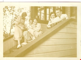
Bea, Elieen, Kay, Wilma and Colin
https://search.heritageburnaby.ca/link/museumdescription2710
- Repository
- Burnaby Village Museum
- Date
- July 24, 1937
- Collection/Fonds
- Hawkshaw family fonds
- Description Level
- Item
- Physical Description
- 1 photograph : sepia ; 5.5 x 8 cm
- Scope and Content
- Photograph of Bea, Eileen, Kay, Wilma and Colin sitting and standing together on the front steps of the Hawkshaw home located at 3908 Deer Lake Avenue (R.F. Anderson house - 6504 Deer Lake Avenue).
- Repository
- Burnaby Village Museum
- Collection/Fonds
- Hawkshaw family fonds
- Description Level
- Item
- Physical Description
- 1 photograph : sepia ; 5.5 x 8 cm
- Scope and Content
- Photograph of Bea, Eileen, Kay, Wilma and Colin sitting and standing together on the front steps of the Hawkshaw home located at 3908 Deer Lake Avenue (R.F. Anderson house - 6504 Deer Lake Avenue).
- Geographic Access
- Deer Lake Avenue
- Accession Code
- BV996.6.151
- Access Restriction
- No restrictions
- Reproduction Restriction
- No known restrictions
- Date
- July 24, 1937
- Media Type
- Photograph
- Historic Neighbourhood
- Burnaby Lake (Historic Neighbourhood)
- Planning Study Area
- Morley-Buckingham Area
- Scan Resolution
- 600
- Scan Date
- 2/18/2010
- Scale
- 100
- Notes
- Title based on contents of photograph
- Caption for photograph reads: "Bea, Eileen Kay Wilma Colin"
- Note in pencil on verso of photograph reads: "July 24/37"
- Photograph is part of photograph album BV996.6.1
Images

![Boal family home, [1938 or 1939] thumbnail](/media/hpo/_Data/_BVM_Images/2017/201700280020_001.jpg?width=280)
Boal family home
https://search.heritageburnaby.ca/link/museumdescription4213
- Repository
- Burnaby Village Museum
- Date
- [1938 or 1939]
- Collection/Fonds
- Burnaby Village Museum Photograph collection
- Description Level
- Item
- Physical Description
- 1 photograph : b&w ; 8 x 12 cm
- Scope and Content
- Photograph of the Boal home at 4319 Norland Ave in Burnaby. The photo is face on to the house looking west(?), the whole house is shown. Mr and Mrs Boal (William Ewart Boal and Ethel May Boal, nee Jackson) are standing on the front porch.
- Repository
- Burnaby Village Museum
- Collection/Fonds
- Burnaby Village Museum Photograph collection
- Description Level
- Item
- Physical Description
- 1 photograph : b&w ; 8 x 12 cm
- Material Details
- Stamped numeral on back of photograph reads: "305".
- Scope and Content
- Photograph of the Boal home at 4319 Norland Ave in Burnaby. The photo is face on to the house looking west(?), the whole house is shown. Mr and Mrs Boal (William Ewart Boal and Ethel May Boal, nee Jackson) are standing on the front porch.
- History
- Material belonged to Glen and Ann Boal (nee Lockhart), who grew up in Burnaby and attended Burnaby South High School. They met and became engaged and married in 1954.
- Geographic Access
- Norland Avenue
- Street Address
- 4319 Norland Avenue
- Accession Code
- BV017.28.20
- Access Restriction
- No restrictions
- Reproduction Restriction
- No known restrictions
- Date
- [1938 or 1939]
- Media Type
- Photograph
- Historic Neighbourhood
- Burnaby Lake (Historic Neighbourhood)
- Planning Study Area
- Burnaby Lake Area
- Scan Resolution
- 600
- Scan Date
- 06-Mar-2018
- Notes
- Title based on contents of photograph
Images
![Boal family home, [1938 or 1939] thumbnail](/media/hpo/_Data/_BVM_Images/2017/201700280020_001.jpg)
![Boal family home, [1938 or 1939] thumbnail](/media/hpo/_Data/_BVM_Images/2017/201700280021_001.jpg?width=280)
Boal family home
https://search.heritageburnaby.ca/link/museumdescription4214
- Repository
- Burnaby Village Museum
- Date
- [1938 or 1939]
- Collection/Fonds
- Burnaby Village Museum Photograph collection
- Description Level
- Item
- Physical Description
- 1 photograph : b&w ; 8 x 12 cm
- Scope and Content
- Photograph of the Boal home at 4319 Norland Ave in Burnaby. The photo is face on to the house looking west(?), the whole house is shown. Mr and Mrs Boal (William Ewart Boal and Ethel May Boal, nee Jackson) are standing on the front porch.
- Repository
- Burnaby Village Museum
- Collection/Fonds
- Burnaby Village Museum Photograph collection
- Description Level
- Item
- Physical Description
- 1 photograph : b&w ; 8 x 12 cm
- Material Details
- Stamped numeral on back of photograph reads: "51".
- Scope and Content
- Photograph of the Boal home at 4319 Norland Ave in Burnaby. The photo is face on to the house looking west(?), the whole house is shown. Mr and Mrs Boal (William Ewart Boal and Ethel May Boal, nee Jackson) are standing on the front porch.
- History
- Material belonged to Glen and Ann Boal (nee Lockhart), who grew up in Burnaby and attended Burnaby South High School. They met and became engaged and married in 1954.
- Geographic Access
- Norland Avenue
- Street Address
- 4319 Norland Avenue
- Accession Code
- BV017.28.21
- Access Restriction
- No restrictions
- Reproduction Restriction
- No known restrictions
- Date
- [1938 or 1939]
- Media Type
- Photograph
- Historic Neighbourhood
- Burnaby Lake (Historic Neighbourhood)
- Planning Study Area
- Burnaby Lake Area
- Scan Resolution
- 600
- Scan Date
- 06-Mar-2018
- Notes
- Title based on contents of photograph
Images
![Boal family home, [1938 or 1939] thumbnail](/media/hpo/_Data/_BVM_Images/2017/201700280021_001.jpg)
![Canoe floating on flooded farm, [1948] thumbnail](/media/hpo/_Data/_BVM_Images/2017/2017_0024_0012_001.jpg?width=280)
Canoe floating on flooded farm
https://search.heritageburnaby.ca/link/museumdescription4059
- Repository
- Burnaby Village Museum
- Date
- [1948]
- Collection/Fonds
- Julie Lee and Cecil Lee family fonds
- Description Level
- Item
- Physical Description
- 1 photograph (tiff) : sepia ; 1000 dpi
- Scope and Content
- Photograph of Suey Ying Jung (Laura) and Puy Yuen Chan in a canoe on the flooded family farm; background contains trees and a building.
- Repository
- Burnaby Village Museum
- Collection/Fonds
- Julie Lee and Cecil Lee family fonds
- Description Level
- Item
- Physical Description
- 1 photograph (tiff) : sepia ; 1000 dpi
- Scope and Content
- Photograph of Suey Ying Jung (Laura) and Puy Yuen Chan in a canoe on the flooded family farm; background contains trees and a building.
- Accession Code
- BV017.24.12
- Access Restriction
- No restrictions
- Reproduction Restriction
- No known restrictions
- Date
- [1948]
- Media Type
- Photograph
- Historic Neighbourhood
- Burnaby Lake (Historic Neighbourhood)
- Planning Study Area
- Douglas-Gilpin Area
- Scan Resolution
- 1000
- Scan Date
- 01-Oct-2017
- Scale
- 100
- Notes
- Title based on contents of photograph
Images
![Canoe floating on flooded farm, [1948] thumbnail](/media/hpo/_Data/_BVM_Images/2017/2017_0024_0012_001.jpg)
![Chapel at Fairacres, [between 1939 and 1954] (date of original), copied 1979 thumbnail](/media/hpo/_Data/_BVM_Images/1979/1979_0034_0002_001.jpg?width=280)
Chapel at Fairacres
https://search.heritageburnaby.ca/link/museumdescription1629
- Repository
- Burnaby Village Museum
- Date
- [between 1939 and 1954] (date of original), copied 1979
- Collection/Fonds
- Burnaby Village Museum Photograph collection
- Description Level
- Item
- Physical Description
- 1 photograph : b&w ; 20.3 x 25.2 cm print
- Scope and Content
- Photograph of the chapel of the Order of St. Benedict at the Ceperley Mansion when they purchased and occupied the mansion from 1939 to 1954. They converted the drawing room into a chapel, placing the altar in front of the fireplace. A platform with a cross on a table. The letters "LOCUS ISTE SANCT…
- Repository
- Burnaby Village Museum
- Collection/Fonds
- Burnaby Village Museum Photograph collection
- Description Level
- Item
- Physical Description
- 1 photograph : b&w ; 20.3 x 25.2 cm print
- Scope and Content
- Photograph of the chapel of the Order of St. Benedict at the Ceperley Mansion when they purchased and occupied the mansion from 1939 to 1954. They converted the drawing room into a chapel, placing the altar in front of the fireplace. A platform with a cross on a table. The letters "LOCUS ISTE SANCTUS EST" are inscribed on the wall above the cross. There is a picture of baby Jesus held by the Virgin Mary on one side of the platform, and a Saint holding a baby on the other.
- Names
- Westminster Priory
- Geographic Access
- Deer Lake Avenue
- Street Address
- 6344 Deer Lake Avenue
- Accession Code
- HV979.34.2
- Access Restriction
- Restricted access
- Reproduction Restriction
- May be restricted by third party rights
- Date
- [between 1939 and 1954] (date of original), copied 1979
- Media Type
- Photograph
- Historic Neighbourhood
- Burnaby Lake (Historic Neighbourhood)
- Planning Study Area
- Douglas-Gilpin Area
- Scan Resolution
- 600
- Scan Date
- 2023-09-12
- Notes
- Title based on contents of photograph
Images
![Chapel at Fairacres, [between 1939 and 1954] (date of original), copied 1979 thumbnail](/media/hpo/_Data/_BVM_Images/1979/1979_0034_0002_001.jpg)
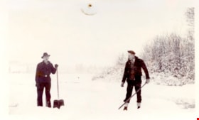
Clearing rink on Deer Lake
https://search.heritageburnaby.ca/link/museumdescription5095
- Repository
- Burnaby Village Museum
- Date
- 1933
- Collection/Fonds
- Waplington family fonds
- Description Level
- Item
- Physical Description
- 1 photograph : b&w ; 7.5 x 12.3 cm
- Scope and Content
- Photograph Jack Waplington and an unidentifed man clearing snow off of Deer Lake for a skating rink.
- Repository
- Burnaby Village Museum
- Collection/Fonds
- Waplington family fonds
- Description Level
- Item
- Physical Description
- 1 photograph : b&w ; 7.5 x 12.3 cm
- Scope and Content
- Photograph Jack Waplington and an unidentifed man clearing snow off of Deer Lake for a skating rink.
- Subjects
- Natural Phenomena - Snow
- Names
- Waplington, John "Jack"
- Geographic Access
- Deer Lake Avenue
- Street Address
- 3813 Deer Lake Avenue
- Accession Code
- BV016.46.66
- Access Restriction
- No restrictions
- Reproduction Restriction
- No known restrictions
- Date
- 1933
- Media Type
- Photograph
- Historic Neighbourhood
- Burnaby Lake (Historic Neighbourhood)
- Planning Study Area
- Morley-Buckingham Area
- Scan Resolution
- 600
- Scan Date
- 13-Aug-2018
- Notes
- Title based on contents of photograph gathered from page of album
- Photograph is part of Photograph album BV016.46.52
Images

![Climbing onto a diving platform, [between 1925 and 1939] thumbnail](/media/hpo/_Data/_BVM_Images/2000/200400220005.jpg?width=280)
Climbing onto a diving platform
https://search.heritageburnaby.ca/link/museumdescription1753
- Repository
- Burnaby Village Museum
- Date
- [between 1925 and 1939]
- Collection/Fonds
- Burnaby Village Museum Photograph collection
- Description Level
- Item
- Physical Description
- 1 photograph : sepia ; 13 x 8 cm
- Scope and Content
- Photograph of an unidentified woman in a tank-style swimsuit climbing onto a wooden diving platform in Deer Lake.
- Repository
- Burnaby Village Museum
- Collection/Fonds
- Burnaby Village Museum Photograph collection
- Description Level
- Item
- Physical Description
- 1 photograph : sepia ; 13 x 8 cm
- Scope and Content
- Photograph of an unidentified woman in a tank-style swimsuit climbing onto a wooden diving platform in Deer Lake.
- Geographic Access
- Deer Lake
- Accession Code
- BV004.22.5
- Access Restriction
- No restrictions
- Reproduction Restriction
- No known restrictions
- Date
- [between 1925 and 1939]
- Media Type
- Photograph
- Historic Neighbourhood
- Burnaby Lake (Historic Neighbourhood)
- Planning Study Area
- Morley-Buckingham Area
- Scan Resolution
- 600
- Scan Date
- 09-Jun-09
- Scale
- 100
- Notes
- Title based on contents of photograph
Images
![Climbing onto a diving platform, [between 1925 and 1939] thumbnail](/media/hpo/_Data/_BVM_Images/2000/200400220005.jpg)
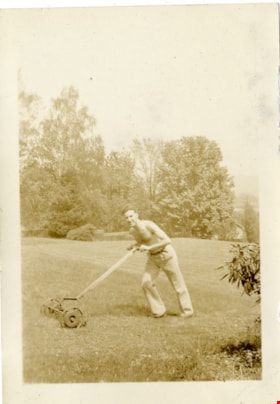
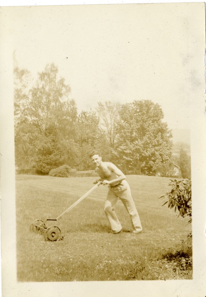
Crichton Hawkshaw
https://search.heritageburnaby.ca/link/museumdescription2669
- Repository
- Burnaby Village Museum
- Date
- 1937
- Collection/Fonds
- Hawkshaw family fonds
- Description Level
- Item
- Physical Description
- 1 photograph : sepia ; 5.5 x 8 cm
- Scope and Content
- Photograph of Crichton Hawkshaw pushing a lawn mower in the yard of house located at 3908 Deer Lake Avenue (6504 Deer Lake Avenue) in Burnaby where Crichton's mother Mabel Hawkshaw lived in 1937. Crichton is mowing the lawn with his shirt off. Tall trees and fence are visible behind.
- Repository
- Burnaby Village Museum
- Collection/Fonds
- Hawkshaw family fonds
- Description Level
- Item
- Physical Description
- 1 photograph : sepia ; 5.5 x 8 cm
- Scope and Content
- Photograph of Crichton Hawkshaw pushing a lawn mower in the yard of house located at 3908 Deer Lake Avenue (6504 Deer Lake Avenue) in Burnaby where Crichton's mother Mabel Hawkshaw lived in 1937. Crichton is mowing the lawn with his shirt off. Tall trees and fence are visible behind.
- Geographic Access
- Deer Lake Avenue
- Accession Code
- BV996.6.133
- Access Restriction
- No restrictions
- Reproduction Restriction
- No known restrictions
- Date
- 1937
- Media Type
- Photograph
- Historic Neighbourhood
- Burnaby Lake (Historic Neighbourhood)
- Planning Study Area
- Morley-Buckingham Area
- Scan Resolution
- 600
- Scan Date
- 2/9/2010
- Scale
- 100
- Notes
- Title based on contents of photograph
- Caption for photograph reads: "Mowing"
- Photograph is part of photograph album BV996.6.1
Images
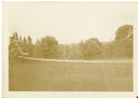
Crichton Hawkshaw
https://search.heritageburnaby.ca/link/museumdescription2671
- Repository
- Burnaby Village Museum
- Date
- 1937
- Collection/Fonds
- Hawkshaw family fonds
- Description Level
- Item
- Physical Description
- 1 photograph : sepia ; 5.5 x 8 cm
- Scope and Content
- Photograph of Crichton Hawkshaw jumping over a sports net.
- Repository
- Burnaby Village Museum
- Collection/Fonds
- Hawkshaw family fonds
- Description Level
- Item
- Physical Description
- 1 photograph : sepia ; 5.5 x 8 cm
- Scope and Content
- Photograph of Crichton Hawkshaw jumping over a sports net.
- Subjects
- Recreational Activities
- Geographic Access
- Deer Lake Avenue
- Accession Code
- BV996.6.135
- Access Restriction
- No restrictions
- Reproduction Restriction
- No known restrictions
- Date
- 1937
- Media Type
- Photograph
- Historic Neighbourhood
- Burnaby Lake (Historic Neighbourhood)
- Planning Study Area
- Morley-Buckingham Area
- Scan Resolution
- 600
- Scan Date
- 2/9/2010
- Scale
- 100
- Notes
- Title based on contents of photograph
- Caption for photograph reads: "Just"
- Photograph is part of photograph album BV996.6.1
Images
