Narrow Results By
Subject
- Advertising Medium - Signs and Signboards 2
- Animals - Cats 2
- Animals - Dogs 2
- Buildings - Commercial - Service Stations 5
- Buildings - Industrial 1
- Buildings - Religious - Churches 1
- Buildings - Residential - Houses 2
- Clothing - Uniforms 2
- Events - May Day 30
- Events - Openings 1
- Events - Parades 3
- Geographic Features - Gardens 1
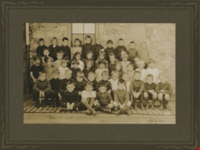
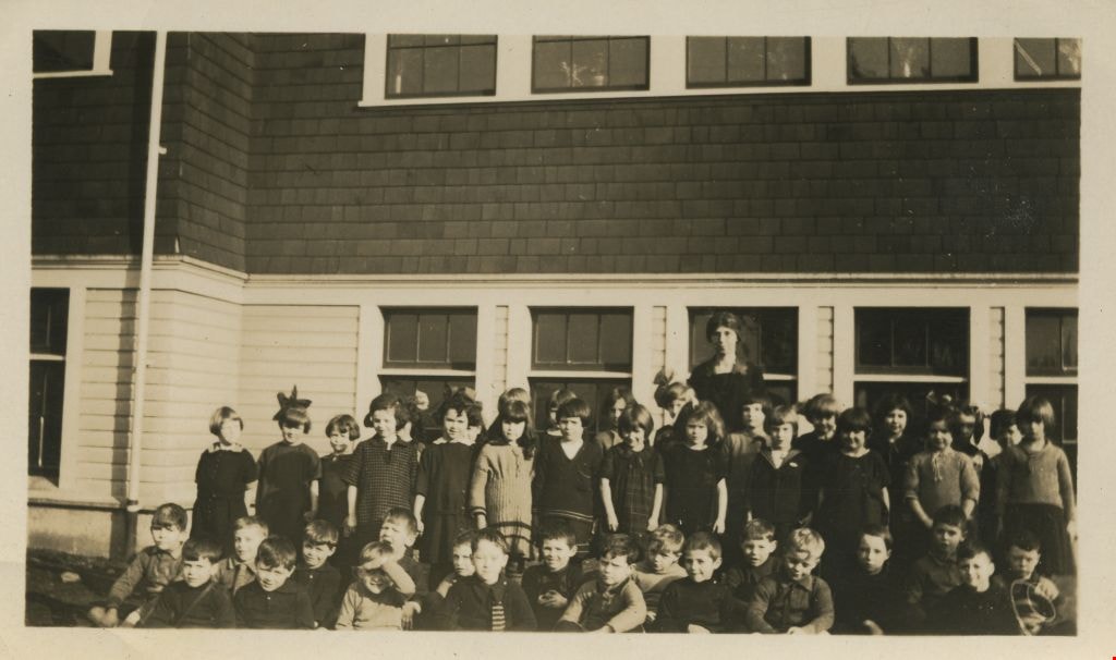
Division XIII at Kingsway West School
https://search.heritageburnaby.ca/link/museumdescription1373
- Repository
- Burnaby Village Museum
- Date
- 1922
- Collection/Fonds
- Burnaby Village Museum Photograph collection
- Description Level
- Item
- Physical Description
- 1 photograph : sepia ; 10 x 15.5 cm, mounted on card 20 x 25 cm
- Scope and Content
- Photograph of Division XIII at Kingsway West School, sitting and standing in four rows in front of the school building. Standing in the back row (from left) are; Ernie Hughes, Alastair Grant, Melville McHale, Arthur Yeates, Bernard Dermott, Freddy Lloyd, Albert Walker, Leslie Watson, Reggie Coe and…
- Repository
- Burnaby Village Museum
- Collection/Fonds
- Burnaby Village Museum Photograph collection
- Description Level
- Item
- Physical Description
- 1 photograph : sepia ; 10 x 15.5 cm, mounted on card 20 x 25 cm
- Scope and Content
- Photograph of Division XIII at Kingsway West School, sitting and standing in four rows in front of the school building. Standing in the back row (from left) are; Ernie Hughes, Alastair Grant, Melville McHale, Arthur Yeates, Bernard Dermott, Freddy Lloyd, Albert Walker, Leslie Watson, Reggie Coe and Robert McIntosh. Standing in the second row; Virginia Brown, Jean Griffiths, Sylvia Wright, Doreen Gravestock, Laura Chamberlain, Florence Brown, Mabel Gill and Peggy Chisholm. Sitting in the third row; Edna Mayhew, Viola Higgins, [Doreen Fenton], Verna Campbell, Eileen Oben, Hazel King, Mary McLean, Beulah Macmillan, Mandie Everett and [Doreen Fenton]. Sitting in the fourth row; Grant Armour, Arthur James, Freddy Eaglestone, Antony Hedger, Albert Savage, Jack Grocott, John Harding, Wilbert Hamilton, Frank Bailey, Jack Dalziel and Hugh Wilson. Sitting on the wood ground in the front row are; Roy Birtch, Eric Dogley, Gordon Taylor and Herbert Coe. Their teacher, Miss Annie Forrest is not pictured.
- Names
- Kingsway West School
- Hughes, Ernest
- Grant, Alastair
- McHale, Melville
- Yeates, Arthur
- Dermott, Bernard
- Lloyd, Freddy
- Walker, Albert
- Watson, Leslie
- Coe, Reggie
- McIntosh, Robert
- Brown, Virginia
- Griffiths, Jean
- Wright, Sylvia
- Gravestock, Doreen
- Chamberlain, Laura
- Bevan, Florence Brown
- Gill, Mabel
- Chisholm, Peggy
- Mayhew, Edna
- Higgins, Viola
- Fenton, Doreen
- Potkins, Verna Campbell
- Oben, Eileen
- King, Hazel
- McLean, Mary
- Kennedy, Beulah MacMillan
- Everett, Mandie
- Armour, Grant
- James, Arthur
- Eaglestone, Freddy
- Hedger, Anthony
- Savage, Albert
- Grocott, Jack
- Harding, James
- Hamilton, Wilbert
- Bailey, Frank
- Dalziel, Jack
- Wilson, Hugh
- Birtch, Roy
- Dogley, Eric
- Taylor, Gordon
- Coe, Herbert
- Geographic Access
- Kingsway
- Street Address
- 4800 Kingsway
- Accession Code
- BV999.2.63
- Access Restriction
- No restrictions
- Reproduction Restriction
- May be restricted by third party rights
- Date
- 1922
- Media Type
- Photograph
- Historic Neighbourhood
- Central Park (Historic Neighbourhood)
- Planning Study Area
- Maywood Area
- Scan Resolution
- 600
- Scan Date
- 08-Jun-09
- Scale
- 100
- Notes
- Title based on contents of photograph
- Photographer identifies photograph as no. 66
- Note in pencil on recto of photograph reads: "1922"
- Note in black ink on verso of card mount reads: "Div. XIII. Kingsway West School. Sept. - Oct. 1922 / 1st Top row. (Left to right) Ernie Hughes, Alastair Grant, Melville McHale, Arthur Yeates, Bernard Dermott, Freddy Lloyd, Albert Walker, Leslie Watson, Reggie Coe, Robert McIntosh / 2nd row. (left to right), Virginia Brown, Jean Griffiths, Sylvia Wright, Doreen Gravestock, Laura Chamberlain, Florence Brown, Mabel Gill, Peggy Chisholm / 3rd row. (left to right). Edna Mayhew, Viola Higgins, Doreen Fenton, Verna Campbell, Eileen Oben, Hazel King, Mary Mc.Lean, Beulah Macmillan, Mandie Everett, Doreen Fenton / 4th. row. (Left to right) Grant Armour, Arthur James, Freddy Eaglestone, Antony Hedger, Albert Savage, Jack Grocott, John Harding, Wilbert Hamilton, Frank Bailey, Jack Dalziel, Hugh Wilson / 5th row (Left to right). Roy Birtch, Eric Dogley, Gordon Taylor, Herbert Coe. / A. T. Forrest. (Teacher)"
Images

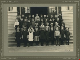
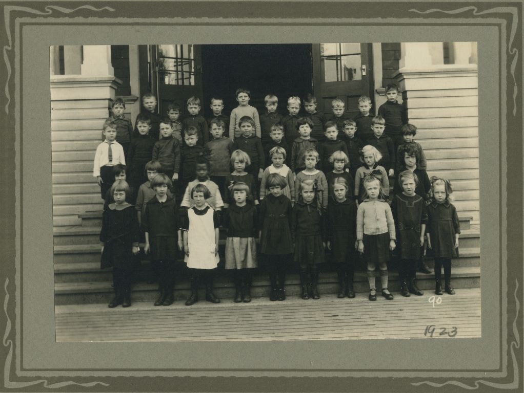
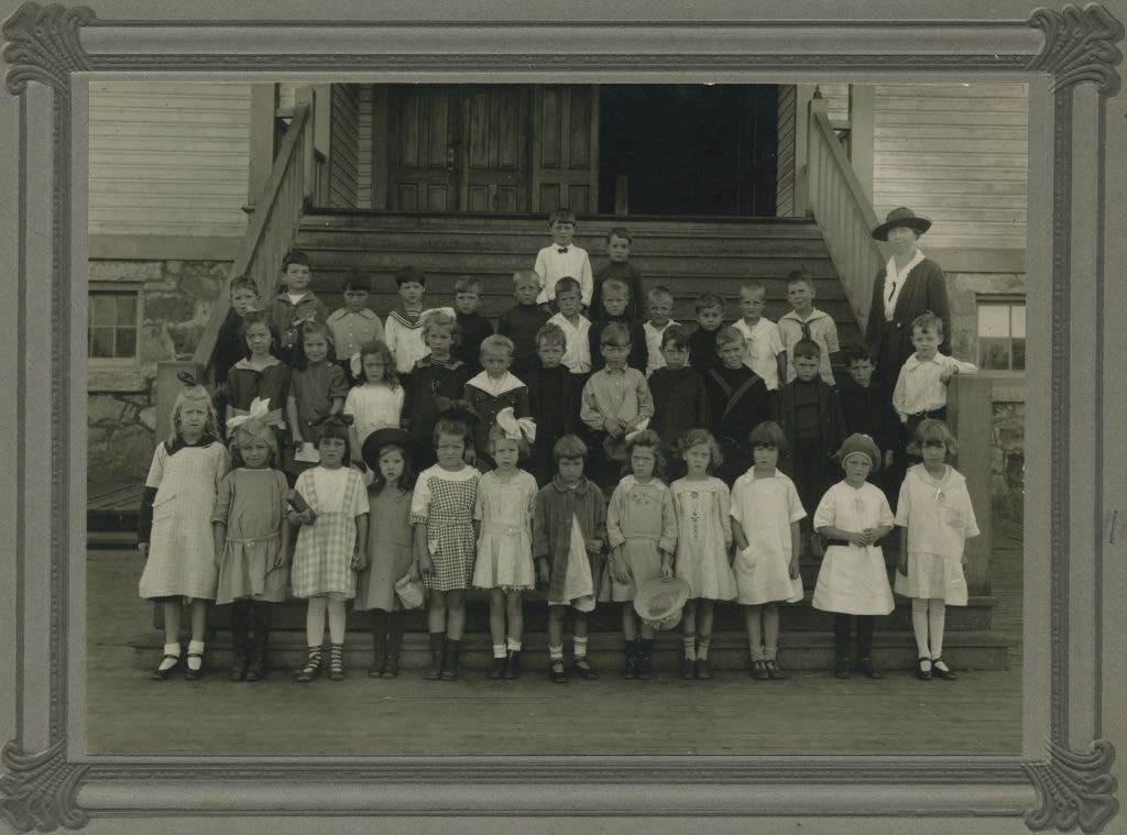
Division XIII at Kingsway West School
https://search.heritageburnaby.ca/link/museumdescription1375
- Repository
- Burnaby Village Museum
- Date
- 1923
- Collection/Fonds
- Burnaby Village Museum Photograph collection
- Description Level
- Item
- Physical Description
- 1 photograph : sepia ; 11.5 x 16 cm, mounted on card 20 x 25 cm
- Scope and Content
- Photograph of Division XIII at Kingsway West School standing in four rows on the front steps of the school building. The students standing in the back row (from left) are; Gordon Sharpe, Lyle O'Connell, Willard Cooper, Arnold Sutherland, Billy Keefer, Desmond Lones, Arnold Cullen, Teddy Cooke, Fran…
- Repository
- Burnaby Village Museum
- Collection/Fonds
- Burnaby Village Museum Photograph collection
- Description Level
- Item
- Physical Description
- 1 photograph : sepia ; 11.5 x 16 cm, mounted on card 20 x 25 cm
- Scope and Content
- Photograph of Division XIII at Kingsway West School standing in four rows on the front steps of the school building. The students standing in the back row (from left) are; Gordon Sharpe, Lyle O'Connell, Willard Cooper, Arnold Sutherland, Billy Keefer, Desmond Lones, Arnold Cullen, Teddy Cooke, Frank Langford, Ronald McLean, Harold Hope and Kenneth Summers. In the second row; Douglas McLean, Gordon King, Evan Gibbons, [illegible] Craig, Arnold Moller, George Crossman, Vincent Watson, Allan [illegible], Milton McHale, Lawrence Rogers, Arnold Cullen and Edmond Goldsmid. In the third row; Pierrette Goldsmid, Eileen Wright, Ada Reid, May Grist, Mildred Harding, Kathleen Howlett, Margaret Thomson, Muriel Phillips and Margaret Cameron. Standing in the front row are; Thelma Griffiths, Jean McLaren, Margaret Stickler, Margaret Morris, Betty Baine, Alice Gunzeon, Grace Clements, Agnes Shewan, Daisy Ford and May Dalziel.
- Names
- Kingsway West School
- Sharpe, Gordon
- O'Connell, Lyle
- Cooper, Willard
- Sutherland, Arnold
- Keefer, Billy
- Lones, Desmond
- Cullen, Arnold
- Cooke, Teddy
- Langford, Frank
- McLean, Ronald
- Hope, Harold
- Summers, Kenneth
- McLean, Douglas
- King, Gordon
- Gibbons, Evan
- Moller, Arnold
- Crossman, George
- Watson, Vincent
- McHale, Milton
- Rogers, Lawrence
- Goldsmid, Edmond
- Goldsmid, Pierrette
- Wright, Eileen
- Reid, Ada
- Grist, May
- Harding, Mildred
- Howlett, Kathleen
- Thomson, Margaret
- Phillips, Muriel
- Cameron, Margaret
- Griffiths, Thelma
- McLaren, Jean
- Stickler, Margaret
- Morris, Margaret
- Baine, Betty
- Geddes, Alice Gunzeon
- Clements, Grace
- Shewan, Agnes
- Ford, Daisy
- Dalziel, May
- Geographic Access
- Kingsway
- Street Address
- 4800 Kingsway
- Accession Code
- BV999.2.65
- Access Restriction
- No restrictions
- Reproduction Restriction
- May be restricted by third party rights
- Date
- 1923
- Media Type
- Photograph
- Historic Neighbourhood
- Central Park (Historic Neighbourhood)
- Planning Study Area
- Maywood Area
- Scan Resolution
- 600
- Scan Date
- 08-Jun-09
- Scale
- 100
- Notes
- Title based on contents of photograph
- Photographer's mark in the lower right-hand corner identifies photograph as no. 90
- Note in pencil on recto of photograph reads: "1923"
- Note in black ink on verso of photograph reads: "Div. XIII Kingsway W. October or Nov. 1923. / A. T. F. (Teacher) / Top row. Left to right. Gordon Sharpe, Lyle O'Connell, Willard Cooper, Arnold Sutherland, Billy Keefer, Desmond Lones, Arnold Cullen, Teddy Cooke, Frank Langford, Ronald McLean, Harold Hope, Kenneth Summers / 2nd row Left to right. Douglas McLean, Gordon King, Evan Gibbons, [illegible] Craig, Arnold Moller, George Crossman, Vincent Watson, Allan [illegible], Milton McHale, Lawrence Rogers, Arnold Cullen, Edmond Goldsmid / 3rd row. Pierrette Goldsmid, Eileen Wright, Ada Reid, May Grist, Mildred Harding, Kathleen Howlett, Margaret Thomson, Muriel Phillips, Margaret Cameron / 4th row. Thelma Griffiths, Jean McLaren, Margaret Stickler, Margaret Morris, Betty Baine, Alice Gunzeon, Grace Clements, Agnes Shewan, Daisy Ford and May Dalziel."
Images
![England family home on Royal Oak Avenue, [between 1927 and 1930] (date of original) , copied 2020 thumbnail](/media/hpo/_Data/_BVM_Images/2020/2020_0009_0002_001.jpg?width=280)
England family home on Royal Oak Avenue
https://search.heritageburnaby.ca/link/museumdescription12230
- Repository
- Burnaby Village Museum
- Date
- [between 1927 and 1930] (date of original) , copied 2020
- Collection/Fonds
- Mary England fonds
- Description Level
- Item
- Physical Description
- 1 photograph (tiff) : b&w ; 600 dpi
- Scope and Content
- Photograph of a Craftsman style house located at 1906 Royal Oak Avenue near Victory Street in Burnaby (address was changed to 7353 Royal Oak Aveue after 1958). The house was built in 1914 and was the home of Alfred Henry and Mary England (nee Gooding). Alfred H. England died suddenly in 1917. Mary…
- Repository
- Burnaby Village Museum
- Collection/Fonds
- Mary England fonds
- Description Level
- Item
- Physical Description
- 1 photograph (tiff) : b&w ; 600 dpi
- Scope and Content
- Photograph of a Craftsman style house located at 1906 Royal Oak Avenue near Victory Street in Burnaby (address was changed to 7353 Royal Oak Aveue after 1958). The house was built in 1914 and was the home of Alfred Henry and Mary England (nee Gooding). Alfred H. England died suddenly in 1917. Mary England continued to live in the house before settling in a house that she had built on Griffiths Avenue in 1930.
- Subjects
- Buildings - Residential - Houses
- Geographic Access
- Royal Oak Avenue
- Victory Street
- Accession Code
- BV020.9.2
- Access Restriction
- No restrictions
- Reproduction Restriction
- May be restricted by third party rights
- Date
- [between 1927 and 1930] (date of original) , copied 2020
- Media Type
- Photograph
- Historic Neighbourhood
- Central Park (Historic Neighbourhood)
- Alta Vista (Historic Neighbourhood)
- Planning Study Area
- Clinton-Glenwood Area
- Scan Resolution
- 600
- Scan Date
- 12-Feb-20
- Scale
- 100
- Notes
- Title based on contents of photograph
Images
![England family home on Royal Oak Avenue, [between 1927 and 1930] (date of original) , copied 2020 thumbnail](/media/hpo/_Data/_BVM_Images/2020/2020_0009_0002_001.jpg)
Fire insurance plans - Greater Vancouver - Volume XVII - Municipality of Burnaby
https://search.heritageburnaby.ca/link/museumdescription17797
- Repository
- Burnaby Village Museum
- Date
- 1927-1950
- Collection/Fonds
- Burnaby Village Museum Map collection
- Description Level
- Item
- Physical Description
- 4 plans on 4 sheets : col. lithographic prints
- Scope and Content
- Item consists of fire insurance plans titled "Greater Vancouver / Volume XVII / Municipality / of Burnaby" surveyed May 1927, revised in October 1940 and September 1950. Includes a two page key plan (E and F) and two associated plans numbered 1729 and 1738 (located within District Lot 35).
- Repository
- Burnaby Village Museum
- Collection/Fonds
- Burnaby Village Museum Map collection
- Description Level
- Item
- Physical Description
- 4 plans on 4 sheets : col. lithographic prints
- Scope and Content
- Item consists of fire insurance plans titled "Greater Vancouver / Volume XVII / Municipality / of Burnaby" surveyed May 1927, revised in October 1940 and September 1950. Includes a two page key plan (E and F) and two associated plans numbered 1729 and 1738 (located within District Lot 35).
- Publisher
- Plan Department of Fire Branch of British Columbia Underwriters' Association
- Accession Code
- BV987.1.70
- Access Restriction
- No restrictions
- Reproduction Restriction
- May be restricted by third party rights
- Date
- 1927-1950
- Media Type
- Cartographic Material
- Historic Neighbourhood
- Central Park (Historic Neighbourhood)
- Planning Study Area
- Garden Village Area
- Scan Resolution
- 400
- Scan Date
- 2021-11-17
- Notes
- Title based on contents of item
- These plans were removed from a bound book with labels on cover page reading: "Plan No. 90 / THIS INSURANCE PLAN / of / Vancouver VOLUME "8" / IN THE PROPERTY OF THE / British Columbia Insurance Underwriter's Association / Vancouver B.C. / AND IS LOANED / MELVILLE F. THOMSON CO. .../ Date May 26th, 1934"; / "Plan No. 74 / THIS INSURANCE PLAN / OF / VANCOUVER VOLUME "9"" / Plan No. 11 / THIS INSURANCE PLAN / OF / BURNABY VOLUMES 15-19" / "THIS PLAN IS THE PROPERTY OF / THE / BRITISH LAW INSURANCE COMPANY / LIMITED"
- Contact Burnaby Village Museum to view associated fire insurance plans XVIII
![House and garden with Thomas and Bertha Shankie and cat, 1920 (date of original), copied [2016] thumbnail](/media/hpo/_Data/_BVM_Images/2016/201600430066_001.jpg?width=280)
House and garden with Thomas and Bertha Shankie and cat
https://search.heritageburnaby.ca/link/museumdescription4167
- Repository
- Burnaby Village Museum
- Date
- 1920 (date of original), copied [2016]
- Collection/Fonds
- Esther Love Stanley fonds
- Description Level
- Item
- Physical Description
- 1 photograph (tiff)
- Scope and Content
- Photograph of Thomas and Bertha Shankie standing in the front garden of the Shankie family home on Barker Avenue. The man is holding a cat. There is a sign on the house that reads "CAMPEND". A picket fence with a gate runs along the front of the property.
- Repository
- Burnaby Village Museum
- Collection/Fonds
- Esther Love Stanley fonds
- Description Level
- Item
- Physical Description
- 1 photograph (tiff)
- Material Details
- Handwritten text on back reads: "Mom & Dad & Barker St. house / 1920".
- Scope and Content
- Photograph of Thomas and Bertha Shankie standing in the front garden of the Shankie family home on Barker Avenue. The man is holding a cat. There is a sign on the house that reads "CAMPEND". A picket fence with a gate runs along the front of the property.
- Geographic Access
- Barker Avenue
- Street Address
- 5515 Barker Avenue
- Accession Code
- BV016.43.66
- Access Restriction
- No restrictions
- Reproduction Restriction
- May be restricted by third party rights
- Date
- 1920 (date of original), copied [2016]
- Media Type
- Photograph
- Historic Neighbourhood
- Central Park (Historic Neighbourhood)
- Planning Study Area
- Garden Village Area
- Notes
- Title based on contents of photograph.
- Image is from a binder of family history. Binder 3, fruit illustrations on cover, "Family Tree Photos".
- Digital image created from orginal photograph by donor
Images
![House and garden with Thomas and Bertha Shankie and cat, 1920 (date of original), copied [2016] thumbnail](/media/hpo/_Data/_BVM_Images/2016/201600430066_001.jpg)
![Janet and Ramsay Shankie in garden, [14 May 1926] (date of original), copied [2016] thumbnail](/media/hpo/_Data/_BVM_Images/2016/201600430024_001.jpg?width=280)
Janet and Ramsay Shankie in garden
https://search.heritageburnaby.ca/link/museumdescription4124
- Repository
- Burnaby Village Museum
- Date
- [14 May 1926] (date of original), copied [2016]
- Collection/Fonds
- Esther Love Stanley fonds
- Description Level
- Item
- Physical Description
- 1 photograph (tiff)
- Scope and Content
- Photograph of Janet and Ramsay Shankie standing in a garden. Janet is wearing a light coloured dress and is holding a small violin. Ramsay is wearing a white shirt, necktie, and dark shorts. The family's Barker Avenue home and yard is visible behind them.
- Repository
- Burnaby Village Museum
- Collection/Fonds
- Esther Love Stanley fonds
- Description Level
- Item
- Physical Description
- 1 photograph (tiff)
- Material Details
- Handwritten text in white on front of photograph reads: "14 may 1926".
- Scope and Content
- Photograph of Janet and Ramsay Shankie standing in a garden. Janet is wearing a light coloured dress and is holding a small violin. Ramsay is wearing a white shirt, necktie, and dark shorts. The family's Barker Avenue home and yard is visible behind them.
- Subjects
- Musical Instruments
- Geographic Access
- Barker Avenue
- Street Address
- 5515 Barker Avenue
- Accession Code
- BV016.43.24
- Access Restriction
- No restrictions
- Reproduction Restriction
- May be restricted by third party rights
- Date
- [14 May 1926] (date of original), copied [2016]
- Media Type
- Photograph
- Historic Neighbourhood
- Central Park (Historic Neighbourhood)
- Planning Study Area
- Garden Village Area
- Notes
- Title based on contents of photograph.
- Image is from a binder of family history. Binder 1, orange cover "Old Stanley Family Photo / Old Shankie Family Photos / War Photos - Echo Photos".
- Digital image created from orginal photograph by donor
Images
![Janet and Ramsay Shankie in garden, [14 May 1926] (date of original), copied [2016] thumbnail](/media/hpo/_Data/_BVM_Images/2016/201600430024_001.jpg)
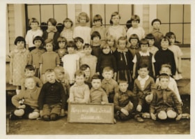
Kingsway West Division 14
https://search.heritageburnaby.ca/link/museumdescription1323
- Repository
- Burnaby Village Museum
- Date
- May 1927
- Collection/Fonds
- Burnaby Village Museum Photograph collection
- Description Level
- Item
- Physical Description
- 1 photograph : sepia ; 11.5 x 16 cm
- Scope and Content
- Photograph of Division 14 at Kingsway West School standing and sitting in five rows in front of the school building windows. Two boys sitting in the front row are holding up a chalk board which reads, "Kingsway West School/ Division 14." Standing in the top row (l to r) are; Audrey Browne, Joan Gol…
- Repository
- Burnaby Village Museum
- Collection/Fonds
- Burnaby Village Museum Photograph collection
- Description Level
- Item
- Physical Description
- 1 photograph : sepia ; 11.5 x 16 cm
- Scope and Content
- Photograph of Division 14 at Kingsway West School standing and sitting in five rows in front of the school building windows. Two boys sitting in the front row are holding up a chalk board which reads, "Kingsway West School/ Division 14." Standing in the top row (l to r) are; Audrey Browne, Joan Gold, Ida Wright, May Ford, Mabel Law, Dorothy Barber, Gladys Would and Isabel McFadyen. In the second row are; Betty Dermott, Maria Soda, Dorothy Guthrie, Pearl Rouse, Norma Moller, Marrion Hickenbotham, Priscilla Deane, Barbara Sleeth and Elsie Brown. In the third row are; Patricia Hodgson, Verna Crane, Gladys Nuttall, Muriel Iraine, Dorothy McKenzie, Doris Faulkner and Mildred Rutledge. Sitting in the fourth row are; James Murie, Bobby Shewan, Donald McKinnon, Howard Griffiths, Henry Nevin and Bobby Ferguson. In the front row are; Harvey Knorr, Alfred Younger, George Chamberlain (holding chalkboard), Ben Jacobson (holding chalkboard), Alex Walker and Garnet Eckard.
- Names
- Kingsway West School
- Browne, Audrey
- Gold, Joan
- Wright, Ida
- Ford, May
- Law, Mabel
- Barber, Dorothy
- Would, Gladys
- McFadyen, Isabel
- Dermott, Betty
- Soda, Maria
- Guthrie, Dorothy
- Rouse, Pearl
- Mollar, Norma
- Hickenbotham, Marion
- Deane, Priscilla
- Sleeth, Barbara
- Brown, Elsie
- Hodgson, Patricia
- Crane, Verna
- Nuttall, Gladys
- Iraine, Muriel
- McKenzie, Dorothy
- Faulkner, Doris
- Rutledge, Mildred
- Murie, James
- Shewan, Bobby
- McKinnon, Donald
- Griffiths, Howard
- Nevin, Henry
- Ferguson, Robert
- Knorr, Harvey
- Younger, Alfred
- Chamberlain, George
- Jacobson, Ben
- Walker, Alex
- Eckard, Garnet
- Geographic Access
- Kingsway
- Street Address
- 4800 Kingsway
- Accession Code
- BV999.2.11
- Access Restriction
- No restrictions
- Reproduction Restriction
- May be restricted by third party rights
- Date
- May 1927
- Media Type
- Photograph
- Historic Neighbourhood
- Central Park (Historic Neighbourhood)
- Planning Study Area
- Maywood Area
- Scan Resolution
- 600
- Scan Date
- 02-Jun-09
- Scale
- 100
- Photographer
- Bryce, Henry G.
- Notes
- Stamps on verso of photograph read: "25cents each. Please/ order number paid for" and "H. G. BRYCE, EDMONDS, B.C."
- Note in black ink on verso of photograph reads: "Div 14. Kingsway W. May, 1927/ Top row - left to right Audrey Browne, Joan Gold, Ida Wright, May Ford, Mabel Law, Dorothy Barber, Gladys Would, Isabel McFadyen / 2nd row lt. to rt. Betty Dermott, Maria Soda, Patricia Hodgson, Dorothy Guthrie, Verna Crane, Pearl Rause, Gladys Nuttal, Norma Moller, Muriel Iraine, Marrion Hickenbotham, Dorothy McKenzie/ 3rd row Doris Faulkner, Barbara Sleeth, Priscilla Deane, Mildred Rutledge, Elsie Brawn, Boys. James Murie, Bobby Shewan, Donald McKinnon, Howard Griffiths, Henry Nevin, Bobby Ferguson/ 2nd row Harvey Knorr, Alfred Younger, George Chamberlain, Ben Jacobson, Alex Walker, Garnet Eckard"
Images


Kingsway West School class
https://search.heritageburnaby.ca/link/museumdescription1343
- Repository
- Burnaby Village Museum
- Date
- February 1925
- Collection/Fonds
- Burnaby Village Museum Photograph collection
- Description Level
- Item
- Physical Description
- 1 photograph : b&w ; 6 x 10.5 cm
- Scope and Content
- Photograph of a class at Kingsway West school sitting and standing in four rows outside the wooden school building. There are nineteen boys sitting in the front two rows and approximately twenty-four girls standing in two rows behind the boys. The teacher, Miss Annie Forrest, is standing in the cen…
- Repository
- Burnaby Village Museum
- Collection/Fonds
- Burnaby Village Museum Photograph collection
- Description Level
- Item
- Physical Description
- 1 photograph : b&w ; 6 x 10.5 cm
- Scope and Content
- Photograph of a class at Kingsway West school sitting and standing in four rows outside the wooden school building. There are nineteen boys sitting in the front two rows and approximately twenty-four girls standing in two rows behind the boys. The teacher, Miss Annie Forrest, is standing in the centre at the back.
- Subjects
- Occupations - Teachers
- Geographic Access
- Kingsway
- Street Address
- 4800 Kingsway
- Accession Code
- BV999.2.31
- Access Restriction
- No restrictions
- Reproduction Restriction
- May be restricted by third party rights
- Date
- February 1925
- Media Type
- Photograph
- Historic Neighbourhood
- Central Park (Historic Neighbourhood)
- Planning Study Area
- Maywood Area
- Scan Resolution
- 600
- Scan Date
- 08-Jun-09
- Scale
- 100
- Notes
- Title based on contents of photograph
- Note in pencil on verso of photograph reads: "Feb. 1925"
- Stamp on verso of photograph reads: "5997"
Images
Kingsway West School class
https://search.heritageburnaby.ca/link/museumdescription1371
- Repository
- Burnaby Village Museum
- Date
- September 1921
- Collection/Fonds
- Burnaby Village Museum Photograph collection
- Description Level
- Item
- Physical Description
- 1 photograph : b&w ; 10 x 14 cm, mounted on card 18 x 20 cm
- Scope and Content
- Photograph of a class at Kingsway West School standing in four rows in front of the school building. Their teacher Miss Annie Forrest stands to the right wearing a hat with a lace brim. The students in the top row (from left) are; Thomas Brown and Lawrence Beaven. In the second row are; Raymond Jon…
- Repository
- Burnaby Village Museum
- Collection/Fonds
- Burnaby Village Museum Photograph collection
- Description Level
- Item
- Physical Description
- 1 photograph : b&w ; 10 x 14 cm, mounted on card 18 x 20 cm
- Scope and Content
- Photograph of a class at Kingsway West School standing in four rows in front of the school building. Their teacher Miss Annie Forrest stands to the right wearing a hat with a lace brim. The students in the top row (from left) are; Thomas Brown and Lawrence Beaven. In the second row are; Raymond Jones, unidentified, Charles Russell, Leonard Wentz, Reggie Mills, Christie Phillips, unidentified, Raymond Pickwell, Teddy Hopper, Albert Hathaway, unidentified and Norman Simpson. In the third row are; Dorothy Huestis, Hope Cooke, Dorothy Kent, Eleanor Phillips, John Harding, John Lepinsky, Spencer Goodall, unidentified, Harold [illegible], Harold Krause, unidentified and unidentified. In the front row none of the girls have been identified (except for the first girl who has been identified only as Helen).
- Subjects
- Occupations - Teachers
- Names
- Kingsway West School
- Forrest, Annie Theresa
- Brown, Thomas
- Beaven, Lawrence
- Jones, Raymond
- Russell, Charles
- Wentz, Leonard
- Philips, Christie
- Pickwell, Raymond
- Hopper, Teddy
- Hathaway, Albert
- Simpson, Norman
- Huestis, Dorothy
- Cooke, Hope
- Kent, Dorothy
- Phillips, Eleanor
- Harding, John
- Lepinsky, John
- Goodall, Spencer
- Krause, Harold
- Geographic Access
- Kingsway
- Street Address
- 4800 Kingsway
- Accession Code
- BV999.2.61
- Access Restriction
- No restrictions
- Reproduction Restriction
- May be restricted by third party rights
- Date
- September 1921
- Media Type
- Photograph
- Historic Neighbourhood
- Central Park (Historic Neighbourhood)
- Planning Study Area
- Maywood Area
- Scan Resolution
- 600
- Scan Date
- 08-Jun-09
- Scale
- 100
- Notes
- Title based on contents of photograph
- Note in pencil on recto of card mount reads: "1921"
- Note in black ink on verso of card mount reads: "Kingsway W. Sept. 1921. Left to right Top row. Thomas Brown Lawrence Beaven / 2nd Left to rt. Raymond Jones. ( (?) ), Charles Russell, Leonard Wentz, Reggie Mills, Christie Phillips, ( - ) Raymond Pickwell, Teddy Hopper, Albert Hathaway, ( ), Norman Simpson / 3rd row. Lt to rt. Dorothy Huestis, Hope Cooke, Dorothy Kent, Eleanor Phillips, John Harding, John Lepinsky, Spencer Goodall, , Harold [illegible], Harold Krause / 4th Helen. , , "
Images
Kingsway West School in "Goldenhair & the Three Bears"
https://search.heritageburnaby.ca/link/museumdescription1056
- Repository
- Burnaby Village Museum
- Date
- [1923]
- Collection/Fonds
- Burnaby Village Museum Photograph collection
- Description Level
- Item
- Physical Description
- 1 photograph : sepia ; 19.4 x 24.2 cm
- Scope and Content
- Photograph of the cast of the Kingsway West School's production of "Goldenhair and the Three Bears." The costumed students, varying in grades and ages, are posed in front of a painted backdrop on a stage. Inscribed on the negative and printed on the photograph, bottom front: "Kingsway West School…
- Repository
- Burnaby Village Museum
- Collection/Fonds
- Burnaby Village Museum Photograph collection
- Description Level
- Item
- Physical Description
- 1 photograph : sepia ; 19.4 x 24.2 cm
- Scope and Content
- Photograph of the cast of the Kingsway West School's production of "Goldenhair and the Three Bears." The costumed students, varying in grades and ages, are posed in front of a painted backdrop on a stage. Inscribed on the negative and printed on the photograph, bottom front: "Kingsway West School in 'Goldenhair & the Three Bears.'" and "Stuart Thomson / Vancouver / B.C." In a letter written to the museum in 1973, the donor states, "This Kingsway West School concert was held fifty odd years ago, I believe in the then 'Phillips Hall' at the corner of McKay Avenue and the old interurban line."
- Subjects
- Performances - Concerts
- Names
- Kingsway West School
- Geographic Access
- McKay Avenue
- Street Address
- 6285 McKay Avenue
- Accession Code
- HV973.158.1
- Access Restriction
- No restrictions
- Reproduction Restriction
- No known restrictions
- Date
- [1923]
- Media Type
- Photograph
- Historic Neighbourhood
- Central Park (Historic Neighbourhood)
- Planning Study Area
- Maywood Area
- Scan Resolution
- 600
- Scan Date
- 2023-06-06
- Photographer
- Thomson, Stuart
- Notes
- Title based on caption of photograph
Images

![Kingsway West School staff, [192-] thumbnail](/media/hpo/_Data/_BVM_Images/2012/2012_0020_0008_001.jpg?width=280)
Kingsway West School staff
https://search.heritageburnaby.ca/link/museumdescription2945
- Repository
- Burnaby Village Museum
- Date
- [192-]
- Collection/Fonds
- Burnaby Village Museum Photograph collection
- Description Level
- Item
- Physical Description
- 1 photograph : b&w ; 14 x 9 cm
- Scope and Content
- Photograph of Kingsway West School teaching staff outside on the school grounds. Back row, left to right: Mr. William D. Blair (principal), Miss M. Bloomfield, Miss Annie Theresa Forrest (much loved by generations of younger children in her Grade 1 class), Miss Edith Kay, Miss Daisy Bodley, Miss Be…
- Repository
- Burnaby Village Museum
- Collection/Fonds
- Burnaby Village Museum Photograph collection
- Description Level
- Item
- Physical Description
- 1 photograph : b&w ; 14 x 9 cm
- Material Details
- photograph framed with decorative art deco design
- Scope and Content
- Photograph of Kingsway West School teaching staff outside on the school grounds. Back row, left to right: Mr. William D. Blair (principal), Miss M. Bloomfield, Miss Annie Theresa Forrest (much loved by generations of younger children in her Grade 1 class), Miss Edith Kay, Miss Daisy Bodley, Miss Bert Thompson, Mr. William Wallace (vice principal), Miss Morgan, Miss Grimwood, Miss Doris Scott, and Mr. George Sievers. Front row, left to right: Mrs. Cassie Roberts, Miss Dorothy Black, Miss Christine Goodman, and Miss Rose Mould. Margaret Gooding was absent.
- Subjects
- Occupations - Teachers
- Names
- Kingsway West School
- Black, Dorothy
- Blair, William D
- Bloomfield, M.
- Bodley, Daisy
- Forrest, Annie Theresa
- Goodman, Christine
- Kay, Edith
- Mould, Rose
- Roberts, Cassie
- Scott, Doris
- Sievers, George
- Thompson, Bert
- Wallace, William
- Geographic Access
- Kingsway
- Street Address
- 4800 Kingsway
- Accession Code
- BV012.20.8
- Access Restriction
- No restrictions
- Reproduction Restriction
- No known restrictions
- Date
- [192-]
- Media Type
- Photograph
- Historic Neighbourhood
- Central Park (Historic Neighbourhood)
- Planning Study Area
- Maywood Area
- Scan Resolution
- 600
- Scan Date
- 13-Mar-2018
- Notes
- Title based on contents of photograph
Images
![Kingsway West School staff, [192-] thumbnail](/media/hpo/_Data/_BVM_Images/2012/2012_0020_0008_001.jpg)
![Minnie Coe and Evelyn Condio, [between 1910 and 1929] thumbnail](/media/hpo/_Data/_BVM_Images/2000/200100010347.jpg?width=280)
Minnie Coe and Evelyn Condio
https://search.heritageburnaby.ca/link/museumdescription1643
- Repository
- Burnaby Village Museum
- Date
- [between 1910 and 1929]
- Collection/Fonds
- Burnaby Village Museum Photograph collection
- Description Level
- Item
- Physical Description
- 1 photograph : sepia ; 14 x 8 cm
- Scope and Content
- Photograph of cousins Mignon (Minnie) Coe and Evelyn Condio standing together in front of the arbour at the Coe family residence at 2684 Fern Avenue (renumbered in the 6300 block). Mignon Coe (later Uter) was the daughter of Elizabeth and James Coe.
- Repository
- Burnaby Village Museum
- Collection/Fonds
- Burnaby Village Museum Photograph collection
- Description Level
- Item
- Physical Description
- 1 photograph : sepia ; 14 x 8 cm
- Scope and Content
- Photograph of cousins Mignon (Minnie) Coe and Evelyn Condio standing together in front of the arbour at the Coe family residence at 2684 Fern Avenue (renumbered in the 6300 block). Mignon Coe (later Uter) was the daughter of Elizabeth and James Coe.
- Geographic Access
- Fern Avenue
- Accession Code
- BV001.1.347
- Access Restriction
- No restrictions
- Date
- [between 1910 and 1929]
- Media Type
- Photograph
- Historic Neighbourhood
- Central Park (Historic Neighbourhood)
- Planning Study Area
- Marlborough Area
- Scan Resolution
- 600
- Scan Date
- 09-Jun-09
- Scale
- 100
- Notes
- Title based on contents of photograph
- Note in pencil on verso of photograph reads: "Minnie Coe + Evelyn Condio cousin"
Images
![Minnie Coe and Evelyn Condio, [between 1910 and 1929] thumbnail](/media/hpo/_Data/_BVM_Images/2000/200100010347.jpg)

Municipality of Burnaby - Volume XV and Volume XVIII
https://search.heritageburnaby.ca/link/museumdescription8680
- Repository
- Burnaby Village Museum
- Date
- May 1927
- Collection/Fonds
- Burnaby Village Museum Map collection
- Description Level
- File
- Physical Description
- 4 plans on 4 sheets : col. lithographic prints ; 63.5 x 53.5 cm folded to 53 x 31.5 cm
- Scope and Content
- File consists of four pages of plans removed from a bound book containing a series of fire insurance plans of the Municipality of Burnaby. The first two pages are numbered "A" and "B" and are key plans from "GREATER VANCOUVER B.C. / VOLUME XV / Surveyed _ May 1927 / MUNICIPALITY OF / BURNABY", "PLA…
- Repository
- Burnaby Village Museum
- Collection/Fonds
- Burnaby Village Museum Map collection
- Description Level
- File
- Physical Description
- 4 plans on 4 sheets : col. lithographic prints ; 63.5 x 53.5 cm folded to 53 x 31.5 cm
- Material Details
- Scales [1:1200] and [1:6000]
- Scope and Content
- File consists of four pages of plans removed from a bound book containing a series of fire insurance plans of the Municipality of Burnaby. The first two pages are numbered "A" and "B" and are key plans from "GREATER VANCOUVER B.C. / VOLUME XV / Surveyed _ May 1927 / MUNICIPALITY OF / BURNABY", "PLAN DEPT. FIRE BRANCH _ B.C. INSURANCE UNDERWRITERS ASSN.". Key Plan "B" covers plans: 1505; 1506; 1512 to 1516; 1540 to 1544; 1550 to 1557 and District Lots: 129 to 132; 135 to 138; 205 to 208 and 215 to 218. Key Plan "A" covers plans: 1501 to 1504; 1507 to 1511; 1517 to 1525; 1531 to 1539; 1545 to 1550 and District Lots: 116 to 127 and 186 to 189. Plan "1806" is part of "GREATER VANCOUVER B.C. / VOLUME XVIII / Municipality of Burnaby / May, 1927" and covers District Lot 153. Plan "1807" is from "GREATER VANCOUVER B.C. / VOLUME XVIII / Municipality of Burnaby / May, 1927" and covers District Lots: 99,149 and 152.
- Responsibility
- British Columbia Underwriters' Association
- Accession Code
- HV972.111.2
- Access Restriction
- No restrictions
- Reproduction Restriction
- May be restricted by third party rights
- Date
- May 1927
- Media Type
- Cartographic Material
- Historic Neighbourhood
- Vancouver Heights (Historic Neighbourhood)
- Lochdale (Historic Neighbourhood)
- Capitol Hill (Historic Neighbourhood)
- Central Park (Historic Neighbourhood)
- Alta Vista (Historic Neighbourhood)
- Planning Study Area
- Burnaby Heights Area
- Sperling-Broadway Area
- Lochdale Area
- Parkcrest-Aubrey Area
- Westridge Area
- Willingdon Heights Area
- Capitol Hill Area
- Maywood Area
- Marlborough Area
- Scan Resolution
- 400
- Scan Date
- 2021-11-18
- Notes
- Title based on content of plans
- Scales are measured 1 inch = 100 feet and 1 inch = 500 feet
- See also BV987.1.70d for revised versions of plans
Zoomable Images


Municipality of Burnaby - Volume XV and Volume XVIII
https://search.heritageburnaby.ca/link/museumdescription8681
- Repository
- Burnaby Village Museum
- Date
- May 1927
- Collection/Fonds
- Burnaby Village Museum Map collection
- Description Level
- File
- Physical Description
- 4 plans on 4 sheets : col. lithographic prints, ms. annotations in blue ink ; 63.5 x 53.5 cm folded to 53 x 31.5 cm
- Scope and Content
- File consists of four pages of plans removed from a bound book containing a series of fire insurance plans of the Municipality of Burnaby. Plan "1507" and plan "1517" are from "GREATER VANCOUVER B.C. / VOLUME XV / Municipality of Burnaby / May, 1927". Plan "1507" covers District Lot 186 and plan "1…
- Repository
- Burnaby Village Museum
- Collection/Fonds
- Burnaby Village Museum Map collection
- Description Level
- File
- Physical Description
- 4 plans on 4 sheets : col. lithographic prints, ms. annotations in blue ink ; 63.5 x 53.5 cm folded to 53 x 31.5 cm
- Material Details
- Scale [1:600] and [1:1200]
- Scope and Content
- File consists of four pages of plans removed from a bound book containing a series of fire insurance plans of the Municipality of Burnaby. Plan "1507" and plan "1517" are from "GREATER VANCOUVER B.C. / VOLUME XV / Municipality of Burnaby / May, 1927". Plan "1507" covers District Lot 186 and plan "1517" covers District Lot 116. Plan "1804" and plan "1805" are from "GREATER VANCOUVER B.C. / VOLUME XVIII / Municipality of Burnaby / May, 1927". Plans "1804" and "1805" cover District Lot 153.
- Responsibility
- British Columbia Underwriters' Association
- Accession Code
- HV972.111.3
- Access Restriction
- No restrictions
- Reproduction Restriction
- May be restricted by third party rights
- Date
- May 1927
- Media Type
- Cartographic Material
- Historic Neighbourhood
- Central Park (Historic Neighbourhood)
- Vancouver Heights (Historic Neighbourhood)
- Planning Study Area
- Maywood Area
- Willingdon Heights Area
- Scan Resolution
- 400
- Scan Date
- 2021-11-18
- Notes
- Title based on content of plans
- See also BV987.1.70d for revised versions of plans
- Scale is measured 1 inch = 100 feet
Images


![Municipality of Burnaby - Volume XV and Volume XVIII, 1927-[1940] thumbnail](/media/hpo/_Data/_BVM_Artifacts/1972/1972_0111_0004_003.jpg?width=280)
Municipality of Burnaby - Volume XV and Volume XVIII
https://search.heritageburnaby.ca/link/museumdescription8682
- Repository
- Burnaby Village Museum
- Date
- 1927-[1940]
- Collection/Fonds
- Burnaby Village Museum Map collection
- Description Level
- File
- Physical Description
- 4 plans on 4 sheets: col. lithographic prints ; 63.5 x 53.5 cm folded to 53 x 31.5 cm
- Scope and Content
- File consists of four pages of plans removed from a bound book containing a series of fire insurance plans of the Municipality of Burnaby. Plan "1518" and "1519" are from "GREATER VANCOUVER B.C. / VOLUME XV / Municipality of Burnaby / May, 1927". Plan "1518" covers District Lot 116 and Plan "1519"…
- Repository
- Burnaby Village Museum
- Collection/Fonds
- Burnaby Village Museum Map collection
- Description Level
- File
- Physical Description
- 4 plans on 4 sheets: col. lithographic prints ; 63.5 x 53.5 cm folded to 53 x 31.5 cm
- Material Details
- Scale [1:600]
- Scope and Content
- File consists of four pages of plans removed from a bound book containing a series of fire insurance plans of the Municipality of Burnaby. Plan "1518" and "1519" are from "GREATER VANCOUVER B.C. / VOLUME XV / Municipality of Burnaby / May, 1927". Plan "1518" covers District Lot 116 and Plan "1519" covers District Lot 121. Plan "1802" and plan "1803" are from "GREATER VANCOUVER B.C. / VOLUME XVIII / Municipality of Burnaby / May, 1927". Both plans "1802" and "1803" cover District Lot 153.
- Responsibility
- British Columbia Underwriters' Association
- Accession Code
- HV972.111.4
- Access Restriction
- No restrictions
- Reproduction Restriction
- May be restricted by third party rights
- Date
- 1927-[1940]
- Media Type
- Cartographic Material
- Historic Neighbourhood
- Vancouver Heights (Historic Neighbourhood)
- Central Park (Historic Neighbourhood)
- Planning Study Area
- Willingdon Heights Area
- Marlborough Area
- Scan Resolution
- 400
- Scan Date
- 2021-11-18
- Notes
- Title based on content of plans
- See also BV987.1.70d for revised versions of plans
- Scale is measured 1 inch = 50 feet
- Contact Burnaby Village Museum to access plans 1518 and 1519 (these plans have revisions on top - date of revisions is uncertain)
Images
![Municipality of Burnaby - Volume XV and Volume XVIII, 1927-[1940] thumbnail](/media/hpo/_Data/_BVM_Artifacts/1972/1972_0111_0004_003.jpg)


Municipality of Burnaby - Volume XVI and Volume XVII
https://search.heritageburnaby.ca/link/museumdescription8684
- Repository
- Burnaby Village Museum
- Date
- May 1927
- Collection/Fonds
- Burnaby Village Museum Map collection
- Description Level
- File
- Physical Description
- 4 plans on 4 sheets : col. lithographic prints ; 63.5 x 53.5 cm folded to 53 x 31.5 cm
- Scope and Content
- File consists of four pages of plans removed from a bound book containing a series of fire insurance plans of the Municipality of Burnaby. Page "D" is titled: "GREATER VANCOUVER B.C. / VOLUME XVI / Surveyed _ May 1927 / MUNICIPALITY OF / BURNABY / PLAN DEPT. FIRE BRANCH _ B.C. INSURANCE UNDERWRITE…
- Repository
- Burnaby Village Museum
- Collection/Fonds
- Burnaby Village Museum Map collection
- Description Level
- File
- Physical Description
- 4 plans on 4 sheets : col. lithographic prints ; 63.5 x 53.5 cm folded to 53 x 31.5 cm
- Material Details
- Scale [1:1200] and [1:6000]
- Scope and Content
- File consists of four pages of plans removed from a bound book containing a series of fire insurance plans of the Municipality of Burnaby. Page "D" is titled: "GREATER VANCOUVER B.C. / VOLUME XVI / Surveyed _ May 1927 / MUNICIPALITY OF / BURNABY / PLAN DEPT. FIRE BRANCH _ B.C. INSURANCE UNDERWRITERS ASSN." / KEY PLAN". Plans covered in this "Key Plan" are numbered 1601 to 1626, 1632 and 1651 covering District Lots: 15; 31; 100 to 102; 114; 141 to 144; 147 and 148; 209 to 214. Plan "E" is part of "GREATER VANCOUVER B.C. / VOLUME XVII / Municipality of Burnaby / May 1927" and covers plans: 1701 to 1705; 1711 to 1715; 1723 to 1727; 1729 to 1733; 1737 to 1742 and District Lots: 68 to 74; 80 to 84; 32 to 35 and 38 to 39. Plan marked "F" is a key plan titled: "GREATER VANCOUVER B.C. / VOLUME XVII / Surveyed _ May 1927 / MUNICIPALITY OF / BURNABY and covers plans: 1706 to 1710; 1716 to 1722; 1734 and 1735; 1743 to 1752 and District Lots: 42 to 44; 59; 75 to 80; 83 to 87; 89 to 93 and 130. Plan "1729" is part of "GREATER VANCOUVER B.C. / VOLUME XVII / Municipality of Burnaby / May 1927" and covers District Lots 34 and 35.
- Responsibility
- British Columbia Underwriters' Association
- Accession Code
- HV972.111.6
- Access Restriction
- No restrictions
- Reproduction Restriction
- May be restricted by third party rights
- Date
- May 1927
- Media Type
- Cartographic Material
- Historic Neighbourhood
- Barnet (Historic Neighbourhood)
- Burquitlam (Historic Neighbourhood)
- Central Park (Historic Neighbourhood)
- Burnaby Lake (Historic Neighbourhood)
- Broadview (Historic Neighbourhood)
- Planning Study Area
- Burnaby Mountain Area
- Lyndhurst Area
- Lake City Area
- Cascade-Schou Area
- Garden Village Area
- Douglas-Gilpin Area
- Oakalla Area
- Scan Resolution
- 400
- Scan Date
- 2021-11-18
- Notes
- Title based on content of plans
- See also BV987.1.70d for revised versions of plans
- Scale is measured 1 inch = 500 feet
Zoomable Images


Municipality of Burnaby - Volume XVIII and Volume XIX
https://search.heritageburnaby.ca/link/museumdescription8683
- Repository
- Burnaby Village Museum
- Date
- May 1927
- Collection/Fonds
- Burnaby Village Museum Map collection
- Description Level
- File
- Physical Description
- 2 plans on 2 sheets : col. lithographic prints ; 63.5 x 53.5 cm folded to 53 x 31.5 cm
- Scope and Content
- File consists of two pages of plans removed from a bound book containing a series of fire insurance plans of the Municipality of Burnaby. Plan "1832" is from "GREATER VANCOUVER B.C. / VOLUME XVIII / Municipality of Burnaby / May, 1927" and covers District Lots: 98 and 28. Plan "K" is part of a key …
- Repository
- Burnaby Village Museum
- Collection/Fonds
- Burnaby Village Museum Map collection
- Description Level
- File
- Physical Description
- 2 plans on 2 sheets : col. lithographic prints ; 63.5 x 53.5 cm folded to 53 x 31.5 cm
- Material Details
- Scale [1:1200] to [1:6000]
- Scope and Content
- File consists of two pages of plans removed from a bound book containing a series of fire insurance plans of the Municipality of Burnaby. Plan "1832" is from "GREATER VANCOUVER B.C. / VOLUME XVIII / Municipality of Burnaby / May, 1927" and covers District Lots: 98 and 28. Plan "K" is part of a key plan "GREATER VANCOUVER B.C. / Surveyed VOLUME XIX May 1927 / MUNICIPALITY OF / BURNABY / PLAN DEPT. British Columbia Ins. Underwriters Association / FIRE BRANCH / KEY PLAN", "Scale 500 FT = 1 INCH / FOR REPORT SEE VOL. XV" covering plans: 1901 to 1914 and District Lots: 161; 164 to 167; 155c; 155; 172 and 173.
- Responsibility
- British Columbia Underwriters' Association
- Accession Code
- HV972.111.5
- Access Restriction
- No restrictions
- Reproduction Restriction
- May be restricted by third party rights
- Date
- May 1927
- Media Type
- Cartographic Material
- Historic Neighbourhood
- East Burnaby (Historic Neighbourhood)
- Central Park (Historic Neighbourhood)
- Fraser Arm (Historic Neighbourhood)
- Alta Vista (Historic Neighbourhood)
- Planning Study Area
- Windsor Area
- Marlborough Area
- Second Street Area
- Big Bend Area
- Sussex-Nelson Area
- Scan Resolution
- 400
- Scan Date
- 2021-11-18
- Notes
- Title based on content of plans
- See also BV987.1.70d for revised versions of plans
- Scale is measured 1 inch = 500 feet
Zoomable Images


Municipality of Burnaby - Volume XV, Volume XVI, Volume XVII, Volume XVIII
https://search.heritageburnaby.ca/link/museumdescription8685
- Repository
- Burnaby Village Museum
- Date
- May 1927
- Collection/Fonds
- Burnaby Village Museum Map collection
- Description Level
- File
- Physical Description
- 4 plans on 4 sheets : col. lithographic prints ; 63.5 x 53.5 cm folded to 53 x 31.5 cm
- Scope and Content
- File consists of four pages of plans removed from a bound book containing a series of fire insurance plans of the Municipality of Burnaby. Plan "1531" is part of "GREATER VANCOUVER B.C. / VOLUME XV / Municipality of Burnaby / May 1927" and covers District Lots: 116 and 117. Key Plan "C" is part of …
- Repository
- Burnaby Village Museum
- Collection/Fonds
- Burnaby Village Museum Map collection
- Description Level
- File
- Physical Description
- 4 plans on 4 sheets : col. lithographic prints ; 63.5 x 53.5 cm folded to 53 x 31.5 cm
- Material Details
- Scale [1:600] and [1:1200]
- Scope and Content
- File consists of four pages of plans removed from a bound book containing a series of fire insurance plans of the Municipality of Burnaby. Plan "1531" is part of "GREATER VANCOUVER B.C. / VOLUME XV / Municipality of Burnaby / May 1927" and covers District Lots: 116 and 117. Key Plan "C" is part of "GREATER VANCOUVER B.C. / VOLUME XVI / Municipality of Burnaby / May 1927" and covers plans 1623 to 1651 and District Lots: 1 and 2; 4; 6; 8; 10 to 14; 25; 27; 40; 56 to 58; 88 and 89. Plan "1738" is part of "GREATER VANCOUVER B.C. / VOLUME XVII / Municipality of Burnaby / May 1927" and covers District Lots: 34 and 35. Key plan "G" is part of "GREATER VANCOUVER B.C. / VOLUME XVIII / Municipality of Burnaby / May 1927" and covers plans: 1801 to 1813; 1823; 1824; 1833 to 1838; 1841 to 1853 and District Lots: 32; 93; 94; 97 to 99; 149; 150; 152; 155 to 159; 161 to 164.
- Responsibility
- British Columbia Underwriters' Association
- Accession Code
- HV972.111.7
- Access Restriction
- No restrictions
- Reproduction Restriction
- May be restricted by third party rights
- Date
- May 1927
- Media Type
- Cartographic Material
- Historic Neighbourhood
- Central Park (Historic Neighbourhood)
- Fraser Arm (Historic Neighbourhood)
- Alta Vista (Historic Neighbourhood)
- Broadview (Historic Neighbourhood)
- Vancouver Heights (Historic Neighbourhood)
- Burquitlam (Historic Neighbourhood)
- East Burnaby (Historic Neighbourhood)
- Edmonds (Historic Neighbourhood)
- Lozells (Historic Neighbourhood)
- Planning Study Area
- Clinton-Glenwood Area
- Marlborough Area
- Maywood Area
- Windsor Area
- Big Bend Area
- Garden Village Area
- Willingdon Heights Area
- West Central Valley Area
- Cariboo-Armstrong Area
- Lyndhurst Area
- Cameron Area
- Lake City Area
- Edmonds Area
- Second Street Area
- Sperling-Broadway Area
- Lakeview-Mayfield Area
- Scan Resolution
- 400
- Scan Date
- 2021-11-18
- Notes
- Title based on content of plans
- See also BV987.1.70d for revised versions of plans
- Scale is measured 1 inch = 500 feet
Zoomable Images

Municipality of Burnaby - Volume XV, Volume XVI, Volume XVII, Volume XVIII, May 1927
Zoom into Image

Painting Centre Line on Kingsway
https://search.heritageburnaby.ca/link/museumdescription65
- Repository
- Burnaby Village Museum
- Date
- 1928 (date of original), copied 1971
- Collection/Fonds
- Burnaby Village Museum Photograph collection
- Description Level
- Item
- Physical Description
- 1 photograph : b&w ; 15.0 x 25.2 cm print
- Scope and Content
- Photograph of Frank Warburton sitting backwards on a plank attached to the front of a car, as it is being driven. The make of the car is unidentified, but has wooden spoked wheels, running boards, and a soft convertible top. Mr. Warburton is painting the centre line on Kingsway. The photograph is…
- Repository
- Burnaby Village Museum
- Collection/Fonds
- Burnaby Village Museum Photograph collection
- Description Level
- Item
- Physical Description
- 1 photograph : b&w ; 15.0 x 25.2 cm print
- Scope and Content
- Photograph of Frank Warburton sitting backwards on a plank attached to the front of a car, as it is being driven. The make of the car is unidentified, but has wooden spoked wheels, running boards, and a soft convertible top. Mr. Warburton is painting the centre line on Kingsway. The photograph is taken 1928 at corner of Grimmer and Kingsway. In the background of the photograph, to the left, there are residential houses with a parked car, and to the right, is a tall gas pump.
- Names
- Warburton, Frank
- Geographic Access
- Kingsway
- Grimmer Street
- Accession Code
- HV971.173.1
- Access Restriction
- No restrictions
- Reproduction Restriction
- No known restrictions
- Date
- 1928 (date of original), copied 1971
- Media Type
- Photograph
- Historic Neighbourhood
- Central Park (Historic Neighbourhood)
- Planning Study Area
- Windsor Area
- Scan Resolution
- 600
- Scan Date
- 2023-03-28
- Notes
- Title based on contents of photograph
- The information in scope and content taken from earlier catalgue record from 1976, and verified by various accession and donation paperworks
Images

![Ramsay and Janet Shankie, [between 1926 and 1930] (date of original), copied [2016] thumbnail](/media/hpo/_Data/_BVM_Images/2015/2015_0040_0039.jpg?width=280)
Ramsay and Janet Shankie
https://search.heritageburnaby.ca/link/museumdescription5606
- Repository
- Burnaby Village Museum
- Date
- [between 1926 and 1930] (date of original), copied [2016]
- Collection/Fonds
- Esther Love Stanley fonds
- Description Level
- Item
- Physical Description
- 1 photograph (jpg)
- Scope and Content
- Photograph of young boy, Thomas Ramsay Shankie, and his sister, Janet Shankie Bower, pictured in the garden beside the family home on Barker Avenue. Ramsay is on the left and is playing the violin.
- Repository
- Burnaby Village Museum
- Collection/Fonds
- Esther Love Stanley fonds
- Description Level
- Item
- Physical Description
- 1 photograph (jpg)
- Scope and Content
- Photograph of young boy, Thomas Ramsay Shankie, and his sister, Janet Shankie Bower, pictured in the garden beside the family home on Barker Avenue. Ramsay is on the left and is playing the violin.
- Subjects
- Musical Instruments
- Geographic Access
- Barker Avenue
- Street Address
- 5515 Barker Avenue
- Accession Code
- BV015.40.39
- Access Restriction
- No restrictions
- Reproduction Restriction
- No known restrictions
- Date
- [between 1926 and 1930] (date of original), copied [2016]
- Media Type
- Photograph
- Historic Neighbourhood
- Central Park (Historic Neighbourhood)
- Planning Study Area
- Garden Village Area
- Scan Resolution
- 300
- Scan Date
- 09-Sep-18
- Notes
- Title based on annotations on digital file name
- Digital image created from orginal photograph by donor
Images
![Ramsay and Janet Shankie, [between 1926 and 1930] (date of original), copied [2016] thumbnail](/media/hpo/_Data/_BVM_Images/2015/2015_0040_0039.jpg)