Narrow Results By

Seaforth Schoolhouse
https://search.heritageburnaby.ca/link/landmark541
- Repository
- Burnaby Heritage Planning
- Description
- The Seaforth Schoolhouse is a one-storey wood-frame rectangular plan building with a projecting entry porch, located in the Burnaby Village Museum.
- Associated Dates
- 1922
- Formal Recognition
- Heritage Designation, Community Heritage Register
- Repository
- Burnaby Heritage Planning
- Geographic Access
- Deer Lake Avenue
- Associated Dates
- 1922
- Formal Recognition
- Heritage Designation, Community Heritage Register
- Enactment Type
- Bylaw No. 8148
- Enactment Date
- 03/01/1984
- Description
- The Seaforth Schoolhouse is a one-storey wood-frame rectangular plan building with a projecting entry porch, located in the Burnaby Village Museum.
- Heritage Value
- The heritage value of the Seaforth Schoolhouse lies in its representation of a one-room school once located in one of the city’s rural districts. The school was constructed due to the demand of increasing population after the First World War, in what was then known as the Lozells District, so isolated at the time that parents were concerned about the danger to their children from wild bears and cougars that roamed the area. The school was named after its sponsor, the Seaforth Chapter of the Imperial Order of Daughters of the Empire. Bowman and Cullerne, the architects for the Burnaby School Board, designed the one room schoolhouse. It was constructed by local contractor, Alphonse J. Toebaert, following the standards of British Columbia public school architecture, which specified the plan and orientation of the building. It indicates the values and the design control of school boards of the time, and the central role of the provincial government in setting educational standards. The heritage value of this school also lies in its interpretive value within the Burnaby Village Museum. The site is an important cultural feature for the interpretation of Burnaby’s heritage to the public, illustrating the changes in the local school system over time. The school was moved to Burnaby Village Museum in 1983, and was opened to the public after extensive restoration in 1987. Both the interior and exterior have been restored and interpreted to the date of original construction. The North Vancouver School Board donated most of the early desks, and the remainder of the interior artifacts are from the museum’s own collection.
- Defining Elements
- Key elements that define the heritage character of the Seaforth Schoolhouse include its: - rectangular plan - hipped roof with cedar shingle cladding - hipped-roof entry porch - typical school fenestration of the era, with a bank of double-hung 6-over-6 wooden-sash windows on one facade - cedar shingle cladding - original and authentic interior elements such as interior mouldings, blackboards and desks
- Locality
- Deer Lake Park
- Historic Neighbourhood
- Burnaby Lake (Historic Neighbourhood)
- Planning Study Area
- Morley-Buckingham Area
- Organization
- Seaforth Chapter of the Imperial Order of Daughters of the Empire
- Burnaby School Board
- Burnaby Village Museum
- Architect
- Bowman and Cullerne
- Builder
- Alphonse J. Toebaert
- Function
- Primary Historic--One-Room School
- Primary Current--Museum
- Community
- Burnaby
- Cadastral Identifier
- P.I.D. No. 011-030-356 Legal Description: Parcel 1, District Lot 79 and District Lot 85, Group 1, New Westminster District, Reference Plan 77594
- Boundaries
- Burnaby Village Museum is comprised of a single municipally-owned property located at 6501 Deer Lake Avenue, Burnaby.
- Area
- 38,488.63
- Contributing Resource
- Building
- Landscape Feature
- Structure
- Ownership
- Public (local)
- Documentation
- Heritage Site Files: PC77000 20. City of Burnaby Planning and Building Department, 4949 Canada Way, Burnaby, B.C., V5G 1M2
- Street Address
- 6501 Deer Lake Avenue
Images


Kingsway West School lacrosse team
https://search.heritageburnaby.ca/link/archivedescription35168
- Repository
- City of Burnaby Archives
- Date
- 1923 (date of original), copied 1986
- Collection/Fonds
- Burnaby Historical Society fonds
- Description Level
- Item
- Physical Description
- 1 photograph : b&w ; 12.7 x 17.8 cm print
- Scope and Content
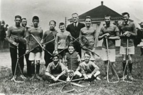
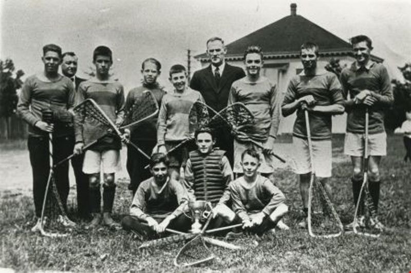
- Photograph of Kingsway West School lacrosse team. Thomas "Tom" Chalmers is 3rd from left. The Burnaby School Board office is visible in the background.
- Repository
- City of Burnaby Archives
- Date
- 1923 (date of original), copied 1986
- Collection/Fonds
- Burnaby Historical Society fonds
- Subseries
- Pioneer Tales subseries
- Physical Description
- 1 photograph : b&w ; 12.7 x 17.8 cm print
- Description Level
- Item
- Record No.
- 204-025
- Access Restriction
- No restrictions
- Reproduction Restriction
- No known restrictions
- Accession Number
- BHS1988-03
- Scope and Content
- Photograph of Kingsway West School lacrosse team. Thomas "Tom" Chalmers is 3rd from left. The Burnaby School Board office is visible in the background.
- Media Type
- Photograph
- Notes
- Title based on contents of photograph
- Geographic Access
- Kingsway
- Street Address
- 4800 Kingsway
- Historic Neighbourhood
- Central Park (Historic Neighbourhood)
- Planning Study Area
- Maywood Area
Images

Douglas Road School
https://search.heritageburnaby.ca/link/landmark573
- Repository
- Burnaby Heritage Planning
- Description
- School building.
- Associated Dates
- 1928
- Other Names
- Douglas Road Elementary School
- Street View URL
- Google Maps Street View
- Repository
- Burnaby Heritage Planning
- Other Names
- Douglas Road Elementary School
- Geographic Access
- Canada Way
- Associated Dates
- 1928
- Description
- School building.
- Heritage Value
- The Douglas Road School was originally established as a two-room school in 1908 on this site, and later expanded to four classrooms. Anticipating rapid settlement of this district, the School Board purchased two acres adjoining the old building. Two of the four rooms were designed to become one large auditorium suitable for special events and public gatherings, with seating for two hundred people. The classically-influenced school has been altered with new windows and extended with additional wings, but has retained its original red-brick veneer, tan-brick quoins and bellcast octagonal roof ventilator. Designed by McCarter & Nairne, the school was built by contractor A.S. Perry. McCarter & Nairne, who also designed the Second Street School, were the Burnaby School Board architects at this time. John Y. McCarter (1886-1981) and George Nairne (1884-1953) formed their partnership in 1921 after serving overseas during the First World War. The partners began designing houses and small apartment buildings, and their commissions included Vancouver’s first skyscraper, the Marine Building (1928-30).
- Locality
- Burnaby Lake
- Historic Neighbourhood
- Burnaby Lake (Historic Neighbourhood)
- Planning Study Area
- Douglas-Gilpin Area
- Architect
- McCarter & Nairne
- Subjects
- Buildings - Heritage
- Buildings - Schools
- Street Address
- 4861 Canada Way
- Street View URL
- Google Maps Street View
Images


Second Street School
https://search.heritageburnaby.ca/link/landmark638
- Repository
- Burnaby Heritage Planning
- Description
- School building.
- Associated Dates
- 1928
- Street View URL
- Google Maps Street View
- Repository
- Burnaby Heritage Planning
- Geographic Access
- 2nd Street
- Associated Dates
- 1928
- Description
- School building.
- Heritage Value
- The Second Street School was originally established at this location as a two-room schoolhouse in 1913 to relieve the overcrowding of Edmonds School during the pre-First World War building boom. The old school was converted into an auditorium when this handsome school building was constructed in 1928. The new school, built by local contractors Ward-Leverington Ltd., included four classrooms, a library, a room for the principal, and a room for the teachers. The original brick façade has been retained although it has been painted; other intact original features include the bellcast octagonal roof ventilator and the protruding front entrance. The Burnaby School Board architect at this time was the talented firm of McCarter & Nairne, who also designed the Douglas Road School. John Y. McCarter (1886-1981) and George Nairne (1884-1953) formed their partnership in 1921 after serving overseas during the First World War. The partners began designing houses and small apartment buildings, and larger commissions soon followed, including Vancouver’s first skyscraper, the Marine Building (1928-30).
- Locality
- East Burnaby
- Historic Neighbourhood
- East Burnaby (Historic Neighbourhood)
- Planning Study Area
- Second Street Area
- Architect
- McCarter & Nairne
- Area
- 15777.66
- Contributing Resource
- Building
- Street Address
- 7502 2nd Street
- Street View URL
- Google Maps Street View
Images


Interview with Edward Apps by Rod Fowler February 22, 1990 - Track 2
https://search.heritageburnaby.ca/link/oralhistory456
- Repository
- City of Burnaby Archives
- Date Range
- 1918-1950
- Length
- 00:05:30
- Summary
- This portion of the interview is about Ed Apps’ brief overview of the changes in Burnaby since he arrived in 1946, where he grew up in England, his war service, and the reasons that he and his wife Margaret immigrated to Canada from England
- Repository
- City of Burnaby Archives
- Summary
- This portion of the interview is about Ed Apps’ brief overview of the changes in Burnaby since he arrived in 1946, where he grew up in England, his war service, and the reasons that he and his wife Margaret immigrated to Canada from England
- Date Range
- 1918-1950
- Length
- 00:05:30
- Subjects
- Migration
- Historic Neighbourhood
- Vancouver Heights (Historic Neighbourhood)
- Planning Study Area
- Burnaby Heights Area
- Interviewer
- Fowler, Rod
- Interview Date
- February 22, 1990
- Scope and Content
- Recording is of an interview with Edward Apps, conducted by Rod Fowler. Ed Apps was one of eleven participants interviewed as part of the SFU/Burnaby Centennial Committee's oral history series titled, "Voices of Burnaby". The interview is mainly about Ed Apps involvement in community groups, particularly his work in seniors organizations lobbying for seniors’ housing since his retirement, and views about the role of Rate Payer groups, unions and politics in the development of North and South Burnaby. He also talks about his origin in England, his war service, arrival with his wife Margaret in Burnaby in 1946, his work with the Burnaby School Board and for the local union, the location of some of the older schools, the history of his house, and briefly about his wife and children. To view “Narrow By” terms for each track expand this description and see “Notes”.
- Biographical Notes
- Edward Apps was born in 1918 in London, England, and grew up in Kent and Essex. In WWII he flew the third glider to land in Normandy on June 6th, 1944. He and his wife Margaret Hope (1915-1985) immigrated to British Columbia in 1946, joining his wife’s parents, who had immigrated earlier in 1939, in Burnaby Heights in North Burnaby. He worked for the Burnaby School Board as Foreman Painter, and served on CUPE Local 379 Executive, until his retirement in 1982. In 1948 Ed Apps bought his first lot, for $150.00, in the 4700 block on Georgia Street, building houses there and in the 4100 block before buying his present home, a ca.1900 farm building, in the same area in 1954. North Burnaby was “bush country and orchards” in the 1950s; his two sons played in the ravines; and the family used the tram system on Hastings and Boundary Road for transportation. Development of municipal services seemed slower in North than South Burnaby, and Ed Apps remembers the strong role Rate Payers groups had in creating local services and lobbying Municipal Council for provide services. After retirement Ed Apps became involved in several local and provincial seniors organizations, advocating for better housing, including serving on the Executives of the Network of Burnaby Seniors and the Council of Senior Citizens Organization, and was active in the provincial Seniors Research and Resource and CMHC Housing Committee. He also served on the Centennial Committee of Burnaby.
- Total Tracks
- 8
- Total Length
- 0:56:50
- Interviewee Name
- Apps, Ed
- Interviewer Bio
- Rod Fowler returned to university as a mature student in the 1980s after working about twenty years in the field of economics and computerization in business in England, Europe and Western Canada. He graduated with a BA from SFU in both History and Sociology in 1987, his MA degree in Geography in 1989, and his PhD in Cultural Geography at SFU. He taught courses in Geography, Sociology, History and Canadian Studies at several Lower Mainland colleges, before becoming a full time member of the Geography Department at Kwantlen University College.
- Collection/Fonds
- SFU/Burnaby Centennial Committee fonds
- Transcript Available
- Transcript available
- Media Type
- Sound Recording
- Web Notes
- Interviews were digitized in 2015 allowing them to be accessible on Heritage Burnaby. The digitization project was initiated by the Community Heritage Commission with support from City of Burnaby Council.
Audio Tracks
Track two of interview with Ed Apps
Track two of interview with Ed Apps
https://search.heritageburnaby.ca/media/hpo/_Data/_Archives_Oral_Histories/_Unrestricted/MSS187-015/MSS187-015_Track_2.mp3