Narrow Results By
Subject
- Advertising Medium - Signs and Signboards 26
- Agriculture - Fruit and Berries 2
- Agriculture - Poultry 1
- Buildings - Agricultural - Greenhouses 1
- Buildings - Civic 4
- Buildings - Civic - Art Galleries 1
- Buildings - Civic - Fire Halls 1
- Buildings - Civic - Hospitals 1
- Buildings - Civic - Museums 1
- Buildings - Commercial 29
- Buildings - Commercial - Automobile Dealerships 3
- Buildings - Commercial - Bakeries 2

Parkcrest Plaza
https://search.heritageburnaby.ca/link/archivedescription93653
- Repository
- City of Burnaby Archives
- Date
- October 23, 1977
- Collection/Fonds
- Burnaby Public Library Contemporary Visual Archive Project
- Description Level
- Item
- Physical Description
- 1 photograph : b&w ; 12.5 x 17.5 cm
- Scope and Content
- Photograph of the Parkcrest Plaza shopping centre at Sperling and Broadway. The photograph is taken from across the parking lot and lawn, facing west. Signs for the plaza's businesses include Fresh Foods and Bank of Nova Scotia, and homes and apartment buildings are in the distance.
- Repository
- City of Burnaby Archives
- Date
- October 23, 1977
- Collection/Fonds
- Burnaby Public Library Contemporary Visual Archive Project
- Physical Description
- 1 photograph : b&w ; 12.5 x 17.5 cm
- Description Level
- Item
- Record No.
- 556-610
- Access Restriction
- No restrictions
- Reproduction Restriction
- Reproduce for fair dealing purposes only
- Accession Number
- 2017-57
- Scope and Content
- Photograph of the Parkcrest Plaza shopping centre at Sperling and Broadway. The photograph is taken from across the parking lot and lawn, facing west. Signs for the plaza's businesses include Fresh Foods and Bank of Nova Scotia, and homes and apartment buildings are in the distance.
- Subjects
- Buildings - Commercial - Grocery Stores
- Buildings - Commercial - Malls
- Buildings - Commercial - Banks
- Buildings - Commercial - Stores
- Media Type
- Photograph
- Photographer
- Chapman, Fred
- Notes
- Title taken from project information form
- Accompanied by a project information form and 1 photograph (b&w negative ; 9.5 x 12.5 cm)
- BPL no. 60
- Geographic Access
- Sperling Avenue
- Broadway
- Street Address
- 5901 Sperling Avenue
- Planning Study Area
- Parkcrest-Aubrey Area
Images


Burnaby Place
https://search.heritageburnaby.ca/link/archivedescription93691
- Repository
- City of Burnaby Archives
- Date
- June 4, 1978
- Collection/Fonds
- Burnaby Public Library Contemporary Visual Archive Project
- Description Level
- Item
- Physical Description
- 1 photograph : b&w ; 12.5 x 17.5 cm
- Scope and Content
- Photograph of a commercial mid-rise building at Patterson Avenue and Kingsway, near Central Park. A Shell gas station is next to the building and a Bank of Nova Scotia occupies the first floor. The photograph is taken from Patterson, facing east on Kingsway. Pedestrians are crossing at the intersec…
- Repository
- City of Burnaby Archives
- Date
- June 4, 1978
- Collection/Fonds
- Burnaby Public Library Contemporary Visual Archive Project
- Physical Description
- 1 photograph : b&w ; 12.5 x 17.5 cm
- Description Level
- Item
- Record No.
- 556-648
- Access Restriction
- No restrictions
- Reproduction Restriction
- Reproduce for fair dealing purposes only
- Accession Number
- 2017-57
- Scope and Content
- Photograph of a commercial mid-rise building at Patterson Avenue and Kingsway, near Central Park. A Shell gas station is next to the building and a Bank of Nova Scotia occupies the first floor. The photograph is taken from Patterson, facing east on Kingsway. Pedestrians are crossing at the intersection.
- Subjects
- Buildings - Commercial
- Buildings - Commercial - Service Stations
- Buildings - Commercial - Banks
- Media Type
- Photograph
- Photographer
- Chapman, Fred
- Notes
- Title taken from project information form
- Accompanied by a project information form and 1 photograph (b&w negative ; 9.5 x 12.5 cm)
- BPL no. 96
- Geographic Access
- Kingsway
- Central Park
- Patterson Avenue
- Historic Neighbourhood
- Central Park (Historic Neighbourhood)
- Planning Study Area
- Maywood Area
Images

![Alice and David Norman in front of store, [between 1925 and 1935] thumbnail](/media/hpo/_Data/_BVM_Images/2023/2023_0015_0002_001.jpg?width=280)
Alice and David Norman in front of store
https://search.heritageburnaby.ca/link/museumdescription20276
- Repository
- Burnaby Village Museum
- Date
- [between 1925 and 1935]
- Collection/Fonds
- Burnaby Village Museum Photograph collection
- Description Level
- Item
- Physical Description
- 1 photograph : b&w negative ; 12.5 x 10 cm
- Scope and Content
- Photograph of Alice Victoria (Goodridge) Norman and her husband David Norman seated on the stoop outside the Goodridge grocery store in Hastings Street in Burnaby. Signage on the windows and on the front of the store identify some of the trademarks of products sold in the store including "Royal Cro…
- Repository
- Burnaby Village Museum
- Collection/Fonds
- Burnaby Village Museum Photograph collection
- Description Level
- Item
- Physical Description
- 1 photograph : b&w negative ; 12.5 x 10 cm
- Scope and Content
- Photograph of Alice Victoria (Goodridge) Norman and her husband David Norman seated on the stoop outside the Goodridge grocery store in Hastings Street in Burnaby. Signage on the windows and on the front of the store identify some of the trademarks of products sold in the store including "Royal Crown Soap", "Cowan's" and "Winchester cigarettes".
- Geographic Access
- Hastings Street
- Accession Code
- BV023.15.2
- Access Restriction
- No restrictions
- Reproduction Restriction
- No known restrictions
- Date
- [between 1925 and 1935]
- Media Type
- Photograph
- Scan Resolution
- 3200
- Scan Date
- 2023-09-21
- Notes
- Title based on contents of photograph
- 1 b&w contact sheet accompanying
Images
![Alice and David Norman in front of store, [between 1925 and 1935] thumbnail](/media/hpo/_Data/_BVM_Images/2023/2023_0015_0002_001.jpg)
![Alice and David Norman seated on front of automobile, [between 1925 and 1935] thumbnail](/media/hpo/_Data/_BVM_Images/2023/2023_0015_0006_001.jpg?width=280)
Alice and David Norman seated on front of automobile
https://search.heritageburnaby.ca/link/museumdescription20280
- Repository
- Burnaby Village Museum
- Date
- [between 1925 and 1935]
- Collection/Fonds
- Burnaby Village Museum Photograph collection
- Description Level
- Item
- Physical Description
- 1 photograph : b&w negative ; 12.5 x 10 cm
- Scope and Content
- Photograph of Alice Victoria (Goodridge) Norman and her husband David Augustus Norman seated on the front of a Model 'T" Ford motor automobile outside of the Goodridge grocery store on located at 4835 Hastings Street in Burnaby.
- Repository
- Burnaby Village Museum
- Collection/Fonds
- Burnaby Village Museum Photograph collection
- Description Level
- Item
- Physical Description
- 1 photograph : b&w negative ; 12.5 x 10 cm
- Scope and Content
- Photograph of Alice Victoria (Goodridge) Norman and her husband David Augustus Norman seated on the front of a Model 'T" Ford motor automobile outside of the Goodridge grocery store on located at 4835 Hastings Street in Burnaby.
- Subjects
- Buildings - Commercial
- Buildings - Commercial - Grocery Stores
- Transportation - Automobiles
- Accession Code
- BV023.15.6
- Access Restriction
- No restrictions
- Reproduction Restriction
- No known restrictions
- Date
- [between 1925 and 1935]
- Media Type
- Photograph
- Scan Resolution
- 3200
- Scan Date
- 2023-09-21
- Notes
- Title based on contents of photograph
- 1 b&w contact sheet accompanying
Images
![Alice and David Norman seated on front of automobile, [between 1925 and 1935] thumbnail](/media/hpo/_Data/_BVM_Images/2023/2023_0015_0006_001.jpg)
![Alice and William Goodridge in front of store, [between 1925 and 1935] thumbnail](/media/hpo/_Data/_BVM_Images/2023/2023_0015_0001_001.jpg?width=280)
Alice and William Goodridge in front of store
https://search.heritageburnaby.ca/link/museumdescription20274
- Repository
- Burnaby Village Museum
- Date
- [between 1925 and 1935]
- Collection/Fonds
- Burnaby Village Museum Photograph collection
- Description Level
- Item
- Physical Description
- 1 photograph : b&w negative ; 12.5 x 10 cm
- Scope and Content
- Photograph of Alice Victoria (Goodridge) Norman and her brother William "Bill" Goodridge seated on the stoop outside the Goodridge grocery store located at 4835 Hastings Street in Burnaby. Signage on the windows and on the front of the store identify some of the trademarks of products sold in the s…
- Repository
- Burnaby Village Museum
- Collection/Fonds
- Burnaby Village Museum Photograph collection
- Description Level
- Item
- Physical Description
- 1 photograph : b&w negative ; 12.5 x 10 cm
- Scope and Content
- Photograph of Alice Victoria (Goodridge) Norman and her brother William "Bill" Goodridge seated on the stoop outside the Goodridge grocery store located at 4835 Hastings Street in Burnaby. Signage on the windows and on the front of the store identify some of the trademarks of products sold in the store including "Royal Crown Soap", "Cowan's" and "Winchester cigarettes". Two post office boxes are visible to the right of the couple.
- Subjects
- Buildings - Commercial
- Buildings - Commercial - Grocery Stores
- Buildings - Public - Post Offices
- Accession Code
- BV023.15.1
- Access Restriction
- No restrictions
- Reproduction Restriction
- No known restrictions
- Date
- [between 1925 and 1935]
- Media Type
- Photograph
- Scan Resolution
- 3200
- Scan Date
- 2023-09-21
- Notes
- Title based on contents of photograph
- 1 b&w contact sheet accompanying
Images
![Alice and William Goodridge in front of store, [between 1925 and 1935] thumbnail](/media/hpo/_Data/_BVM_Images/2023/2023_0015_0001_001.jpg)
![Alice Norman and Bill Goodridge seated on front of automobile, [between 1925 and 1935] thumbnail](/media/hpo/_Data/_BVM_Images/2023/2023_0015_0005_001.jpg?width=280)
Alice Norman and Bill Goodridge seated on front of automobile
https://search.heritageburnaby.ca/link/museumdescription20279
- Repository
- Burnaby Village Museum
- Date
- [between 1925 and 1935]
- Collection/Fonds
- Burnaby Village Museum Photograph collection
- Description Level
- Item
- Physical Description
- 1 photograph : b&w negative ; 12.5 x 10 cm
- Scope and Content
- Photograph of Alice Victoria (Goodridge) Norman and her brother William "Bill" Goodridge seated on the front of a Model 'T" Ford motor automobile outside of the Goodridge grocery store located at 4835 Hastings Street in Burnaby.
- Repository
- Burnaby Village Museum
- Collection/Fonds
- Burnaby Village Museum Photograph collection
- Description Level
- Item
- Physical Description
- 1 photograph : b&w negative ; 12.5 x 10 cm
- Scope and Content
- Photograph of Alice Victoria (Goodridge) Norman and her brother William "Bill" Goodridge seated on the front of a Model 'T" Ford motor automobile outside of the Goodridge grocery store located at 4835 Hastings Street in Burnaby.
- Subjects
- Buildings - Commercial
- Buildings - Commercial - Grocery Stores
- Transportation - Automobiles
- Accession Code
- BV023.15.5
- Access Restriction
- No restrictions
- Reproduction Restriction
- No known restrictions
- Date
- [between 1925 and 1935]
- Media Type
- Photograph
- Scan Resolution
- 3200
- Scan Date
- 2023-09-21
- Notes
- Title based on contents of photograph
- 1 b&w contact sheet accompanying
Images
![Alice Norman and Bill Goodridge seated on front of automobile, [between 1925 and 1935] thumbnail](/media/hpo/_Data/_BVM_Images/2023/2023_0015_0005_001.jpg)

Bakery Opposite Capitol Hill School
https://search.heritageburnaby.ca/link/archivedescription93647
- Repository
- City of Burnaby Archives
- Date
- November 20, 1977
- Collection/Fonds
- Burnaby Public Library Contemporary Visual Archive Project
- Description Level
- Item
- Physical Description
- 1 photograph : b&w ; 12.5 x 17.5 cm
- Scope and Content
- Photograph of the exterior and the parking lot of a bakery on the corner of Holdom Avenue and Hastings Street, across from Capitol Hill Elementary School. The sign reads "Mackey Fine Foods." The photograph is taken facing north from the other side of Hastings Street.
- Repository
- City of Burnaby Archives
- Date
- November 20, 1977
- Collection/Fonds
- Burnaby Public Library Contemporary Visual Archive Project
- Physical Description
- 1 photograph : b&w ; 12.5 x 17.5 cm
- Description Level
- Item
- Record No.
- 556-604
- Access Restriction
- No restrictions
- Reproduction Restriction
- Reproduce for fair dealing purposes only
- Accession Number
- 2017-57
- Scope and Content
- Photograph of the exterior and the parking lot of a bakery on the corner of Holdom Avenue and Hastings Street, across from Capitol Hill Elementary School. The sign reads "Mackey Fine Foods." The photograph is taken facing north from the other side of Hastings Street.
- Media Type
- Photograph
- Photographer
- Chapman, Fred
- Notes
- Title taken from project information form
- Accompanied by a project information form and 1 photograph (b&w negative ; 9.5 x 12.5 cm)
- BPL no. 54
- Geographic Access
- Holdom Avenue
- Hastings Street
- Historic Neighbourhood
- Capitol Hill (Historic Neighbourhood)
- Planning Study Area
- Capitol Hill Area
Images


BC Tel Building
https://search.heritageburnaby.ca/link/archivedescription93609
- Repository
- City of Burnaby Archives
- Date
- October 16, 1977
- Collection/Fonds
- Burnaby Public Library Contemporary Visual Archive Project
- Description Level
- Item
- Physical Description
- 1 photograph : b&w ; 12.5 x 17.5 cm
- Scope and Content
- Photograph of the BC Tel Building (now the Brian Canfield Centre), located at Kingsway and Boundary Road. The photograph is taken facing north and shows the pedestrian overpass over Kingsway and the mountains in the background.
- Repository
- City of Burnaby Archives
- Date
- October 16, 1977
- Collection/Fonds
- Burnaby Public Library Contemporary Visual Archive Project
- Physical Description
- 1 photograph : b&w ; 12.5 x 17.5 cm
- Description Level
- Item
- Record No.
- 556-566
- Access Restriction
- No restrictions
- Reproduction Restriction
- Reproduce for fair dealing purposes only
- Accession Number
- 2017-57
- Scope and Content
- Photograph of the BC Tel Building (now the Brian Canfield Centre), located at Kingsway and Boundary Road. The photograph is taken facing north and shows the pedestrian overpass over Kingsway and the mountains in the background.
- Media Type
- Photograph
- Photographer
- McGillivray, Don
- Notes
- Title taken from project information form
- Accompanied by a project information form and 1 photograph (b&w negative ; 9.5 x 12.5 cm)
- BPL no. 10
- Geographic Access
- Boundary Road
- Kingsway
- Street Address
- 3777 Kingsway
- Historic Neighbourhood
- Central Park (Historic Neighbourhood)
- Planning Study Area
- Garden Village Area
Images


BC Tel Building
https://search.heritageburnaby.ca/link/archivedescription93679
- Repository
- City of Burnaby Archives
- Date
- June 4, 1978
- Collection/Fonds
- Burnaby Public Library Contemporary Visual Archive Project
- Description Level
- Item
- Physical Description
- 1 photograph : b&w ; 12.5 x 17.5 cm
- Scope and Content
- Photograph of the exterior of the BC Tel Building, located at Kingsway and Boundary Road. The photograph is taken from across a lawn and railway tracks, facing southeast. The railway tracks are visible in the bottom left corner of the photograph.
- Repository
- City of Burnaby Archives
- Date
- June 4, 1978
- Collection/Fonds
- Burnaby Public Library Contemporary Visual Archive Project
- Physical Description
- 1 photograph : b&w ; 12.5 x 17.5 cm
- Description Level
- Item
- Record No.
- 556-636
- Access Restriction
- No restrictions
- Reproduction Restriction
- Reproduce for fair dealing purposes only
- Accession Number
- 2017-57
- Scope and Content
- Photograph of the exterior of the BC Tel Building, located at Kingsway and Boundary Road. The photograph is taken from across a lawn and railway tracks, facing southeast. The railway tracks are visible in the bottom left corner of the photograph.
- Media Type
- Photograph
- Photographer
- Chapman, Fred
- Notes
- Title taken from project information form
- Accompanied by a project information form and 1 photograph (b&w negative ; 9.5 x 12.5 cm)
- BPL no. 85
- Geographic Access
- Boundary Road
- Kingsway
- Street Address
- 3777 Kingsway
- Historic Neighbourhood
- Central Park (Historic Neighbourhood)
- Planning Study Area
- Garden Village Area
Images


BC Tel Building
https://search.heritageburnaby.ca/link/archivedescription93680
- Repository
- City of Burnaby Archives
- Date
- June 4, 1978
- Collection/Fonds
- Burnaby Public Library Contemporary Visual Archive Project
- Description Level
- Item
- Physical Description
- 1 photograph : b&w ; 12.5 x 17.5 cm
- Scope and Content
- Photograph of the exterior of the BC Tel Building, located at Kingsway and Boundary Road, and the lawn and neighbourhood surrounding the building. The photograph is taken from across the lawn, facing north. Boundary Road is on the left side of the photograph and the mountains are visible in the bac…
- Repository
- City of Burnaby Archives
- Date
- June 4, 1978
- Collection/Fonds
- Burnaby Public Library Contemporary Visual Archive Project
- Physical Description
- 1 photograph : b&w ; 12.5 x 17.5 cm
- Description Level
- Item
- Record No.
- 556-637
- Access Restriction
- No restrictions
- Reproduction Restriction
- Reproduce for fair dealing purposes only
- Accession Number
- 2017-57
- Scope and Content
- Photograph of the exterior of the BC Tel Building, located at Kingsway and Boundary Road, and the lawn and neighbourhood surrounding the building. The photograph is taken from across the lawn, facing north. Boundary Road is on the left side of the photograph and the mountains are visible in the background.
- Media Type
- Photograph
- Photographer
- Chapman, Fred
- Notes
- Title taken from project information form
- Accompanied by a project information form and 1 photograph (b&w negative ; 9.5 x 12.5 cm)
- BPL no. 86
- Geographic Access
- Kingsway
- Boundary Road
- Street Address
- 3777 Kingsway
- Historic Neighbourhood
- Central Park (Historic Neighbourhood)
- Planning Study Area
- Garden Village Area
Images

![Beatrice Goodridge holding child, [between 1925 and 1935] thumbnail](/media/hpo/_Data/_BVM_Images/2023/2023_0015_0008_001.jpg?width=280)
Beatrice Goodridge holding child
https://search.heritageburnaby.ca/link/museumdescription20282
- Repository
- Burnaby Village Museum
- Date
- [between 1925 and 1935]
- Collection/Fonds
- Burnaby Village Museum Photograph collection
- Description Level
- Item
- Physical Description
- 1 photograph : b&w negative ; 10 x 12.5 cm
- Scope and Content
- Photograph of Beatrice Goodridge holding a child outside the Goodridge grocery store on Hastings Street in Burnaby. The child could be Beatrice's or one of her sister's.
- Repository
- Burnaby Village Museum
- Collection/Fonds
- Burnaby Village Museum Photograph collection
- Description Level
- Item
- Physical Description
- 1 photograph : b&w negative ; 10 x 12.5 cm
- Scope and Content
- Photograph of Beatrice Goodridge holding a child outside the Goodridge grocery store on Hastings Street in Burnaby. The child could be Beatrice's or one of her sister's.
- Accession Code
- BV023.15.8
- Access Restriction
- No restrictions
- Reproduction Restriction
- No known restrictions
- Date
- [between 1925 and 1935]
- Media Type
- Photograph
- Scan Resolution
- 3200
- Scan Date
- 2023-09-21
- Notes
- Title based on contents of photograph
- 1 b&w contact sheet accompanying
Images
![Beatrice Goodridge holding child, [between 1925 and 1935] thumbnail](/media/hpo/_Data/_BVM_Images/2023/2023_0015_0008_001.jpg)

Canada Way Food Market
https://search.heritageburnaby.ca/link/archivedescription79111
- Repository
- City of Burnaby Archives
- Date
- October, 1976
- Collection/Fonds
- Burnaby Public Library Contemporary Visual Archive Project
- Description Level
- Item
- Physical Description
- 1 photograph : b&w ; 11 x 16 cm mounted on cardboard
- Scope and Content
- Photograph shows the Canada Way Food Market at 4694 Canada Way and International Meats at 4692 Canada Way.
- Repository
- City of Burnaby Archives
- Date
- October, 1976
- Collection/Fonds
- Burnaby Public Library Contemporary Visual Archive Project
- Physical Description
- 1 photograph : b&w ; 11 x 16 cm mounted on cardboard
- Description Level
- Item
- Record No.
- 556-159
- Access Restriction
- No restrictions
- Reproduction Restriction
- Reproduce for fair dealing purposes only
- Accession Number
- 2013-13
- Scope and Content
- Photograph shows the Canada Way Food Market at 4694 Canada Way and International Meats at 4692 Canada Way.
- Media Type
- Photograph
- Photographer
- Salmon, Stu
- Notes
- Scope note taken directly from BPL photograph description.
- 1 b&w copy negative : 10 x 12.5 cm accompanying
- Geographic Access
- Canada Way
- Street Address
- 4692 Canada Way
- 4694 Canada Way
- Planning Study Area
- Douglas-Gilpin Area
Images


Crossing Royal Oak & Rumble Street
https://search.heritageburnaby.ca/link/archivedescription93686
- Repository
- City of Burnaby Archives
- Date
- May 19, 1978
- Collection/Fonds
- Burnaby Public Library Contemporary Visual Archive Project
- Description Level
- Item
- Physical Description
- 1 photograph : b&w ; 12.5 x 17.5 cm
- Scope and Content
- Photograph of the intersection of Royal Oak Avenue and Rumble Street. Cars and pedestrians are crossing the intersection, and the signs for businesses TD Bank, Standard Oil/Chevron gas station, Gulf gas station, and Baxter's Market are visible. The photograph is taken from a corner of the intersect…
- Repository
- City of Burnaby Archives
- Date
- May 19, 1978
- Collection/Fonds
- Burnaby Public Library Contemporary Visual Archive Project
- Physical Description
- 1 photograph : b&w ; 12.5 x 17.5 cm
- Description Level
- Item
- Record No.
- 556-643
- Access Restriction
- No restrictions
- Reproduction Restriction
- Reproduce for fair dealing purposes only
- Accession Number
- 2017-57
- Scope and Content
- Photograph of the intersection of Royal Oak Avenue and Rumble Street. Cars and pedestrians are crossing the intersection, and the signs for businesses TD Bank, Standard Oil/Chevron gas station, Gulf gas station, and Baxter's Market are visible. The photograph is taken from a corner of the intersection, facing southeast.
- Subjects
- Geographic Features - Roads
- Advertising Medium - Signs and Signboards
- Buildings - Commercial - Service Stations
- Transportation - Automobiles
- Buildings - Commercial
- Media Type
- Photograph
- Photographer
- van Mannen, Mark
- Notes
- Title taken from project information form
- Accompanied by a project information form and 1 photograph (b&w negative ; 9.5 x 12.5 cm)
- BPL no. 91
- Geographic Access
- Royal Oak Avenue
- Rumble Street
- Historic Neighbourhood
- Alta Vista (Historic Neighbourhood)
- Planning Study Area
- Sussex-Nelson Area
Images


Crossing Royal Oak & Rumble Street
https://search.heritageburnaby.ca/link/archivedescription93687
- Repository
- City of Burnaby Archives
- Date
- May 19, 1978
- Collection/Fonds
- Burnaby Public Library Contemporary Visual Archive Project
- Description Level
- Item
- Physical Description
- 1 photograph : b&w ; 12.5 x 17.5 cm
- Scope and Content
- Photograph of the intersection of Royal Oak Avenue and Rumble Street. Cars and pedestrians are crossing the intersection, and the signs for businesses Grace United Pharmacy, Standard Oil/Chevron gas station, Gulf gas station, and Royal Meats are visible. The photograph is taken from the Gulf gas st…
- Repository
- City of Burnaby Archives
- Date
- May 19, 1978
- Collection/Fonds
- Burnaby Public Library Contemporary Visual Archive Project
- Physical Description
- 1 photograph : b&w ; 12.5 x 17.5 cm
- Description Level
- Item
- Record No.
- 556-644
- Access Restriction
- No restrictions
- Reproduction Restriction
- Reproduce for fair dealing purposes only
- Accession Number
- 2017-57
- Scope and Content
- Photograph of the intersection of Royal Oak Avenue and Rumble Street. Cars and pedestrians are crossing the intersection, and the signs for businesses Grace United Pharmacy, Standard Oil/Chevron gas station, Gulf gas station, and Royal Meats are visible. The photograph is taken from the Gulf gas station parking lot, facing northwest.
- Subjects
- Advertising Medium - Signs and Signboards
- Geographic Features - Roads
- Transportation - Automobiles
- Buildings - Commercial
- Buildings - Commercial - Service Stations
- Media Type
- Photograph
- Photographer
- van Mannen, Mark
- Notes
- Title taken from project information form
- Accompanied by a project information form and 1 photograph (b&w negative ; 9.5 x 12.5 cm)
- BPL no. 92
- Geographic Access
- Royal Oak Avenue
- Rumble Street
- Historic Neighbourhood
- Alta Vista (Historic Neighbourhood)
- Planning Study Area
- Sussex-Nelson Area
Images


Dick's Market
https://search.heritageburnaby.ca/link/archivedescription79125
- Repository
- City of Burnaby Archives
- Date
- October, 1976
- Collection/Fonds
- Burnaby Public Library Contemporary Visual Archive Project
- Description Level
- Item
- Physical Description
- 1 photograph : b&w ; 11 x 16 cm mounted on cardboard
- Scope and Content
- Photograph shows window at Dick's Market at 4152 Hastings Street.
- Repository
- City of Burnaby Archives
- Date
- October, 1976
- Collection/Fonds
- Burnaby Public Library Contemporary Visual Archive Project
- Physical Description
- 1 photograph : b&w ; 11 x 16 cm mounted on cardboard
- Description Level
- Item
- Record No.
- 556-168
- Access Restriction
- No restrictions
- Reproduction Restriction
- Reproduce for fair dealing purposes only
- Accession Number
- 2013-13
- Scope and Content
- Photograph shows window at Dick's Market at 4152 Hastings Street.
- Names
- Dick's Market
- Media Type
- Photograph
- Photographer
- Cook, Alan
- Notes
- Scope note taken directly from BPL photograph description.
- 1 b&w copy negative : 10 x 12.5 cm accompanying
- Geographic Access
- Hastings Street
- Street Address
- 4152 Hastings Street
- Historic Neighbourhood
- Vancouver Heights (Historic Neighbourhood)
- Planning Study Area
- Willingdon Heights Area
Images


Evelyn's Beauty Salon
https://search.heritageburnaby.ca/link/archivedescription79191
- Repository
- City of Burnaby Archives
- Date
- September 22, 1976
- Collection/Fonds
- Burnaby Public Library Contemporary Visual Archive Project
- Description Level
- Item
- Physical Description
- 1 photograph : b&w ; 11 x 16 cm mounted on cardboard
- Scope and Content
- Photograph shows Evelyn's Beauty Salon at 7030 Buller Avenue next door to the P&K Convenient Food Market.
- Repository
- City of Burnaby Archives
- Date
- September 22, 1976
- Collection/Fonds
- Burnaby Public Library Contemporary Visual Archive Project
- Physical Description
- 1 photograph : b&w ; 11 x 16 cm mounted on cardboard
- Description Level
- Item
- Record No.
- 556-199
- Access Restriction
- No restrictions
- Reproduction Restriction
- Reproduce for fair dealing purposes only
- Accession Number
- 2013-13
- Scope and Content
- Photograph shows Evelyn's Beauty Salon at 7030 Buller Avenue next door to the P&K Convenient Food Market.
- Media Type
- Photograph
- Photographer
- Ross, Martha
- Notes
- Scope note taken directly from BPL photograph description.
- 1 b&w copy negative : 10 x 12.5 cm accompanying
- Geographic Access
- Buller Avenue
- Street Address
- 7930 Buller Avenue
- Historic Neighbourhood
- Alta-Vista (Historic Neighbourhood)
- Planning Study Area
- Clinton-Glenwood Area
Images

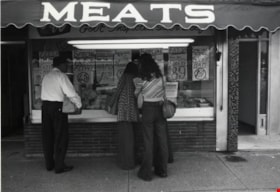
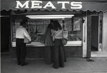
F & W Meat Market
https://search.heritageburnaby.ca/link/archivedescription79124
- Repository
- City of Burnaby Archives
- Date
- October, 1976
- Collection/Fonds
- Burnaby Public Library Contemporary Visual Archive Project
- Description Level
- Item
- Physical Description
- 1 photograph : b&w ; 11 x 16 cm mounted on cardboard
- Scope and Content
- Photograph shows people examining meat in the window of the F & W Meat Market at 4220 Hastings Street.
- Repository
- City of Burnaby Archives
- Date
- October, 1976
- Collection/Fonds
- Burnaby Public Library Contemporary Visual Archive Project
- Physical Description
- 1 photograph : b&w ; 11 x 16 cm mounted on cardboard
- Description Level
- Item
- Record No.
- 556-167
- Access Restriction
- No restrictions
- Reproduction Restriction
- Reproduce for fair dealing purposes only
- Accession Number
- 2013-13
- Scope and Content
- Photograph shows people examining meat in the window of the F & W Meat Market at 4220 Hastings Street.
- Names
- F & W Meat Market
- Media Type
- Photograph
- Photographer
- Cook, Alan
- Notes
- Scope note taken directly from BPL photograph description.
- 1 b&w copy negative : 10 x 12.5 cm accompanying
- Geographic Access
- Hastings Street
- Street Address
- 4220 Hastings Street
- Historic Neighbourhood
- Vancouver Heights (Historic Neighbourhood)
- Planning Study Area
- Willingdon Heights Area
Images

Highrises on Kingsway
https://search.heritageburnaby.ca/link/archivedescription93692
- Repository
- City of Burnaby Archives
- Date
- June 4, 1978
- Collection/Fonds
- Burnaby Public Library Contemporary Visual Archive Project
- Description Level
- Item
- Physical Description
- 1 photograph : b&w ; 12.5 x 17.5 cm
- Scope and Content
- Photograph of high-rises apartment buildings and the neighbourhood along Kingsway by Central Park. The photograph is taken from a high point, facing east down Kingsway. The Central Park Veterinary Hospital, Central Park Place, a railway crossing, a gas station, and the Central Park Gate are visible…
- Repository
- City of Burnaby Archives
- Date
- June 4, 1978
- Collection/Fonds
- Burnaby Public Library Contemporary Visual Archive Project
- Physical Description
- 1 photograph : b&w ; 12.5 x 17.5 cm
- Description Level
- Item
- Record No.
- 556-649
- Access Restriction
- No restrictions
- Reproduction Restriction
- Reproduce for fair dealing purposes only
- Accession Number
- 2017-57
- Scope and Content
- Photograph of high-rises apartment buildings and the neighbourhood along Kingsway by Central Park. The photograph is taken from a high point, facing east down Kingsway. The Central Park Veterinary Hospital, Central Park Place, a railway crossing, a gas station, and the Central Park Gate are visible in the photograph.
- Subjects
- Buildings - Commercial
- Buildings - Residential - Apartments
- Buildings - Commercial - Service Stations
- Geographic Features - Parks
- Monuments
- Media Type
- Photograph
- Photographer
- Chapman, Fred
- Notes
- Title taken from project information form
- Accompanied by a project information form and 1 photograph (b&w negative ; 9.5 x 12.5 cm)
- BPL no. 97
- Geographic Access
- Kingsway
- Central Park
- Historic Neighbourhood
- Central Park (Historic Neighbourhood)
- Planning Study Area
- Maywood Area
Images

![Burton family home, [1945]. Item no. 216-002 thumbnail](/media/hpo/_Data/_Archives_Images/_Unrestricted/205/216-002.jpg?width=280)
Interview with John Burton by Colin Stevens 1988 - Track 3
https://search.heritageburnaby.ca/link/oralhistory216
- Repository
- City of Burnaby Archives
- Date Range
- 1928-1929
- Length
- 0:10:16
- Summary
- This portion of the interview pertains to John Burton's memories of working for Cowan's Music Store as a teenager. He tells the story of a raid at the hotel bar next door.
- Repository
- City of Burnaby Archives
- Summary
- This portion of the interview pertains to John Burton's memories of working for Cowan's Music Store as a teenager. He tells the story of a raid at the hotel bar next door.
- Date Range
- 1928-1929
- Photo Info
- Burton family home, [1945]. Item no. 216-002
- Length
- 0:10:16
- Interviewer
- Stevens, Colin
- Interview Date
- 1988
- Scope and Content
- Recording is of an interview with John Burton conducted by Colin Stevens inside the Music Shop at Burnaby Village Museum, 1988. John Burton discusses his experiences working in music shops in New Westminster in the 1920s. Major themes discussed are: sales, displays, popular culture.
- Biographical Notes
- John Burton was born in 1912 in New Westminster. He went to Second Street School, then Edmonds, then Saint Anne's Convent, and St. Louis College and Connaught before graduating from Burnaby South School in 1930. While at High School, John worked at Cowan's Music Store at 716 Columbia Street in New Westminster on Saturdays and after school. John Burton's grandfather John Foley was the founder of the Orangeville Sun newspaper in Orangeville, Ontario, established in 1861. He ran the paper until his death in 1882, when his son, John Foley Jr. took over as editor and publisher at the age of sixteen. Two of his daughters were involved in the newspaper; Margaret Foley was a regular contributor to the paper, and John Burton's mother was a typesetter. When John Burton was a teenager, he went to Orangeville to learn the trade from his uncle. Unfortunately, he was only there eighteen months when his uncle died December 21, 1932. The family was unable to hold on to the business and the paper amalgamated with the Orangeville Banner newspaper in 1933.
- Total Tracks
- 3
- Total Length
- 0:30:14
- Interviewee Name
- Burton, John
- Interview Location
- Burnaby Village Museum, Burnaby
- Collection/Fonds
- Burnaby Historical Society fonds
- Subseries
- Oral history subseries
- Media Type
- Sound Recording
- Web Notes
- Interview was digitized in 2010 allowing it to be accessible on Heritage Burnaby. The digitization project was initiated by the Community Heritage Commission with support from City of Burnaby Council and the BC History Digitization Program of the Irving K. Barber Learning Centre, University of British Columbia. It was recognized by the Heritage Society of BC with an award in 2012.
Images
![Burton family home, [1945]. Item no. 216-002 thumbnail](/media/hpo/_Data/_Archives_Images/_Unrestricted/205/216-002.jpg)
Audio Tracks
Track three of interview with John Burton by Colin Stevens
Track three of interview with John Burton by Colin Stevens
https://search.heritageburnaby.ca/media/hpo/_Data/_Archives_Oral_Histories/_Unrestricted/MSS137-001-3/MSS137-001-3_Track_3.mp3![John Charles Goodridge holding grandchild, [between 1925 and 1935] thumbnail](/media/hpo/_Data/_BVM_Images/2023/2023_0015_0004_001.jpg?width=280)
John Charles Goodridge holding grandchild
https://search.heritageburnaby.ca/link/museumdescription20278
- Repository
- Burnaby Village Museum
- Date
- [between 1925 and 1935]
- Collection/Fonds
- Burnaby Village Museum Photograph collection
- Description Level
- Item
- Physical Description
- 1 photograph : b&w negative ; 12.5 x 10 cm
- Scope and Content
- Photograph of John Charles Bertram Goodridge holding his grandchild outside the Goodridge grocery store on Hastings Street in Burnaby. Canada Post mail boxes are visible behind them. One of the mail boxes is mounted on the door of the building and the other is free standing.
- Repository
- Burnaby Village Museum
- Collection/Fonds
- Burnaby Village Museum Photograph collection
- Description Level
- Item
- Physical Description
- 1 photograph : b&w negative ; 12.5 x 10 cm
- Scope and Content
- Photograph of John Charles Bertram Goodridge holding his grandchild outside the Goodridge grocery store on Hastings Street in Burnaby. Canada Post mail boxes are visible behind them. One of the mail boxes is mounted on the door of the building and the other is free standing.
- Subjects
- Buildings - Commercial
- Buildings - Commercial - Grocery Stores
- Buildings - Public - Post Offices
- Persons - Children
- Accession Code
- BV023.15.4
- Access Restriction
- No restrictions
- Reproduction Restriction
- No known restrictions
- Date
- [between 1925 and 1935]
- Media Type
- Photograph
- Scan Resolution
- 3200
- Scan Date
- 2023-09-21
- Notes
- Title based on contents of photograph
- 1 b&w contact sheet accompanying
Images
![John Charles Goodridge holding grandchild, [between 1925 and 1935] thumbnail](/media/hpo/_Data/_BVM_Images/2023/2023_0015_0004_001.jpg)