Narrow Results By
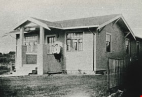
![311 Madison Avenue, [1925] (date of original), copied 1991 thumbnail](/media/hpo/_Data/_Archives_Images/_Unrestricted/370/370-210.jpg?width=280)
311 Madison Avenue
https://search.heritageburnaby.ca/link/archivedescription37622
- Repository
- City of Burnaby Archives
- Date
- [1925] (date of original), copied 1991
- Collection/Fonds
- Burnaby Historical Society fonds
- Description Level
- Item
- Physical Description
- 1 photograph : b&w ; 2.9 x 4.5 cm print on contact sheet 20.2 x 25.3 cm
- Scope and Content
- Photograph of the exterior of 311 Madison Avenue.
- Repository
- City of Burnaby Archives
- Date
- [1925] (date of original), copied 1991
- Collection/Fonds
- Burnaby Historical Society fonds
- Subseries
- Burnaby Image Bank subseries
- Physical Description
- 1 photograph : b&w ; 2.9 x 4.5 cm print on contact sheet 20.2 x 25.3 cm
- Description Level
- Item
- Record No.
- 370-210
- Access Restriction
- No restrictions
- Reproduction Restriction
- No known restrictions
- Accession Number
- BHS1999-03
- Scope and Content
- Photograph of the exterior of 311 Madison Avenue.
- Subjects
- Buildings - Residential - Houses
- Media Type
- Photograph
- Notes
- Title based on contents of photograph
- 1 b&w copy negative accompanying
- Geographic Access
- Madison Avenue
- Street Address
- 311 Madison Avenue
- Historic Neighbourhood
- Vancouver Heights (Historic Neighbourhood)
- Planning Study Area
- Burnaby Heights Area
Images
![311 Madison Avenue, [1925] (date of original), copied 1991 thumbnail](/media/hpo/_Data/_Archives_Images/_Unrestricted/370/370-210.jpg)
![805 Grove Avenue, [1925] (date of original), copied 1991 thumbnail](/media/hpo/_Data/_Archives_Images/_Unrestricted/370/370-274.jpg?width=280)
805 Grove Avenue
https://search.heritageburnaby.ca/link/archivedescription37686
- Repository
- City of Burnaby Archives
- Date
- [1925] (date of original), copied 1991
- Collection/Fonds
- Burnaby Historical Society fonds
- Description Level
- Item
- Physical Description
- 1 photograph : b&w ; 2.9 x 5.0 cm print on contact sheet 20.2 x 25.3 cm
- Scope and Content
- Photograph of the exterior of the house at 805 Grove Avenue.
- Repository
- City of Burnaby Archives
- Date
- [1925] (date of original), copied 1991
- Collection/Fonds
- Burnaby Historical Society fonds
- Subseries
- Burnaby Image Bank subseries
- Physical Description
- 1 photograph : b&w ; 2.9 x 5.0 cm print on contact sheet 20.2 x 25.3 cm
- Description Level
- Item
- Record No.
- 370-274
- Access Restriction
- No restrictions
- Reproduction Restriction
- No known restrictions
- Accession Number
- BHS1999-03
- Scope and Content
- Photograph of the exterior of the house at 805 Grove Avenue.
- Subjects
- Buildings - Residential - Houses
- Media Type
- Photograph
- Notes
- Title based on contents of photograph
- 1 b&w copy negative accompanying
- Negative has a pink cast
- Geographic Access
- Grove Avenue
- Street Address
- 805 Grove Avenue
- Historic Neighbourhood
- Lochdale (Historic Neighbourhood)
- Planning Study Area
- Lochdale Area
Images
![805 Grove Avenue, [1925] (date of original), copied 1991 thumbnail](/media/hpo/_Data/_Archives_Images/_Unrestricted/370/370-274.jpg)
![2700 Block Willingdon Avenue, [1928] (date of original), copied 1991 thumbnail](/media/hpo/_Data/_Archives_Images/_Unrestricted/370/370-105.jpg?width=280)
2700 Block Willingdon Avenue
https://search.heritageburnaby.ca/link/archivedescription37517
- Repository
- City of Burnaby Archives
- Date
- [1928] (date of original), copied 1991
- Collection/Fonds
- Burnaby Historical Society fonds
- Description Level
- Item
- Physical Description
- 1 photograph : b&w ; 4.5 x 2.6 cm print on contact sheet 20.3 x 25.3 cm
- Scope and Content
- Photograph of neighbours of the Murley family on the 2700 block of Willingdon Avenue (later renumbered as the 6300 block of Willingdon Avenue). A woman and two children are standing in front of a house.
- Repository
- City of Burnaby Archives
- Date
- [1928] (date of original), copied 1991
- Collection/Fonds
- Burnaby Historical Society fonds
- Subseries
- Burnaby Image Bank subseries
- Physical Description
- 1 photograph : b&w ; 4.5 x 2.6 cm print on contact sheet 20.3 x 25.3 cm
- Description Level
- Item
- Record No.
- 370-105
- Access Restriction
- No restrictions
- Reproduction Restriction
- No known restrictions
- Accession Number
- BHS1999-03
- Scope and Content
- Photograph of neighbours of the Murley family on the 2700 block of Willingdon Avenue (later renumbered as the 6300 block of Willingdon Avenue). A woman and two children are standing in front of a house.
- Subjects
- Buildings - Residential - Houses
- Media Type
- Photograph
- Notes
- Title based on contents of photograph
- 1 b&w copy negative accompanying
- Geographic Access
- Willingdon Avenue
- Historic Neighbourhood
- Central Park (Historic Neighbourhood)
- Planning Study Area
- Maywood Area
Images
![2700 Block Willingdon Avenue, [1928] (date of original), copied 1991 thumbnail](/media/hpo/_Data/_Archives_Images/_Unrestricted/370/370-105.jpg)
![3900 Albert Street - South Side, [196-] thumbnail](/media/hpo/_Data/_Archives_Images/_Unrestricted/316/366-027.jpg?width=280)
3900 Albert Street - South Side
https://search.heritageburnaby.ca/link/archivedescription97610
- Repository
- City of Burnaby Archives
- Date
- [196-]
- Collection/Fonds
- Burnaby Historical Society fonds
- Description Level
- Item
- Physical Description
- 1 photograph : b&w negative
- Scope and Content
- Photograph of two houses on the south corner of Albert Street and Ingleton Avenue at 3900 Albert Street.
- Repository
- City of Burnaby Archives
- Date
- [196-]
- Collection/Fonds
- Burnaby Historical Society fonds
- Subseries
- Municipal record subseries
- Physical Description
- 1 photograph : b&w negative
- Description Level
- Item
- Record No.
- 366-027
- Access Restriction
- No restrictions
- Reproduction Restriction
- Reproduce for fair dealing purposes only
- Accession Number
- BHS1998-12
- Scope and Content
- Photograph of two houses on the south corner of Albert Street and Ingleton Avenue at 3900 Albert Street.
- Subjects
- Buildings - Residential - Houses
- Media Type
- Photograph
- Notes
- Transcribed title
- Note on verso of photograph in black ink reads: "3900 Albert - South Side - Two Houses at East End of Block"
- Geographic Access
- Albert Street
- Street Address
- 3900 Albert Street
- Historic Neighbourhood
- Vancouver Heights (Historic Neighbourhood)
- Planning Study Area
- Burnaby Heights Area
Images
![3900 Albert Street - South Side, [196-] thumbnail](/media/hpo/_Data/_Archives_Images/_Unrestricted/316/366-027.jpg)
![3980 Albert Street, [between 1965 and 1970] thumbnail](/media/hpo/_Data/_Archives_Images/_Unrestricted/316/366-024.jpg?width=280)
3980 Albert Street
https://search.heritageburnaby.ca/link/archivedescription37395
- Repository
- City of Burnaby Archives
- Date
- [between 1965 and 1970]
- Collection/Fonds
- Burnaby Historical Society fonds
- Description Level
- Item
- Physical Description
- 1 photograph : b&w negative
- Scope and Content
- Photograph of the home located at 3980 Albert Street (old street number).
- Repository
- City of Burnaby Archives
- Date
- [between 1965 and 1970]
- Collection/Fonds
- Burnaby Historical Society fonds
- Subseries
- Municipal record subseries
- Physical Description
- 1 photograph : b&w negative
- Description Level
- Item
- Record No.
- 366-024
- Access Restriction
- No restrictions
- Reproduction Restriction
- Reproduce for fair dealing purposes only
- Accession Number
- BHS1998-12
- Scope and Content
- Photograph of the home located at 3980 Albert Street (old street number).
- Subjects
- Buildings - Residential - Houses
- Media Type
- Photograph
- Notes
- Title based on contents of photograph
- Geographic Access
- Albert Street
- Historic Neighbourhood
- Vancouver Heights (Historic Neighbourhood)
- Planning Study Area
- Burnaby Heights Area
Images
![3980 Albert Street, [between 1965 and 1970] thumbnail](/media/hpo/_Data/_Archives_Images/_Unrestricted/316/366-024.jpg)
![3980 Albert Street, [between 1965 and 1970] thumbnail](/media/hpo/_Data/_Archives_Images/_Unrestricted/316/366-025.jpg?width=280)
3980 Albert Street
https://search.heritageburnaby.ca/link/archivedescription37396
- Repository
- City of Burnaby Archives
- Date
- [between 1965 and 1970]
- Collection/Fonds
- Burnaby Historical Society fonds
- Description Level
- Item
- Physical Description
- 1 photograph : b&w negative
- Scope and Content
- Photograph of a house located at 3980 Albert Street (old street number).
- Repository
- City of Burnaby Archives
- Date
- [between 1965 and 1970]
- Collection/Fonds
- Burnaby Historical Society fonds
- Subseries
- Municipal record subseries
- Physical Description
- 1 photograph : b&w negative
- Description Level
- Item
- Record No.
- 366-025
- Access Restriction
- No restrictions
- Reproduction Restriction
- Reproduce for fair dealing purposes only
- Accession Number
- BHS1998-12
- Scope and Content
- Photograph of a house located at 3980 Albert Street (old street number).
- Subjects
- Buildings - Residential - Houses
- Media Type
- Photograph
- Notes
- Title based on contents of photograph
- Geographic Access
- Albert Street
- Historic Neighbourhood
- Vancouver Heights (Historic Neighbourhood)
- Planning Study Area
- Burnaby Heights Area
Images
![3980 Albert Street, [between 1965 and 1970] thumbnail](/media/hpo/_Data/_Archives_Images/_Unrestricted/316/366-025.jpg)
![4042 Yale Street, [1961 or 1962] (date of original), copied 1991 thumbnail](/media/hpo/_Data/_Archives_Images/_Unrestricted/370/370-213.jpg?width=280)
4042 Yale Street
https://search.heritageburnaby.ca/link/archivedescription37625
- Repository
- City of Burnaby Archives
- Date
- [1961 or 1962] (date of original), copied 1991
- Collection/Fonds
- Burnaby Historical Society fonds
- Description Level
- Item
- Physical Description
- 1 photograph : b&w ; 3.9 x 3.9 cm print on contact sheet 20.2 x 25.3 cm
- Scope and Content
- Photograph of 4042 Yale Street, taken from behind and above the house. The photograph was taken facing north, with the north shore mountains visible in the background. The photograph was taken during the winter of 1961 to 1962, and there is snow.
- Repository
- City of Burnaby Archives
- Date
- [1961 or 1962] (date of original), copied 1991
- Collection/Fonds
- Burnaby Historical Society fonds
- Subseries
- Burnaby Image Bank subseries
- Physical Description
- 1 photograph : b&w ; 3.9 x 3.9 cm print on contact sheet 20.2 x 25.3 cm
- Description Level
- Item
- Record No.
- 370-213
- Access Restriction
- No restrictions
- Reproduction Restriction
- No restrictions
- Accession Number
- BHS1999-03
- Scope and Content
- Photograph of 4042 Yale Street, taken from behind and above the house. The photograph was taken facing north, with the north shore mountains visible in the background. The photograph was taken during the winter of 1961 to 1962, and there is snow.
- Media Type
- Photograph
- Notes
- Title based on contents of photograph
- 1 b&w copy negative accompanying
- Geographic Access
- Yale Street
- Street Address
- 4042 Yale Street
- Historic Neighbourhood
- Vancouver Heights (Historic Neighbourhood)
- Planning Study Area
- Burnaby Heights Area
Images
![4042 Yale Street, [1961 or 1962] (date of original), copied 1991 thumbnail](/media/hpo/_Data/_Archives_Images/_Unrestricted/370/370-213.jpg)
![4042 Yale Street, [1961 or 1962] (date of original), copied 1991 thumbnail](/media/hpo/_Data/_Archives_Images/_Unrestricted/370/370-214.jpg?width=280)
4042 Yale Street
https://search.heritageburnaby.ca/link/archivedescription37626
- Repository
- City of Burnaby Archives
- Date
- [1961 or 1962] (date of original), copied 1991
- Collection/Fonds
- Burnaby Historical Society fonds
- Description Level
- Item
- Physical Description
- 1 photograph : b&w ; 3.9 x 3.9 cm print on contact sheet 20.2 x 25.3 cm
- Scope and Content
- Photograph from above 4042 Yale Street looking northeast. Burrard Inlet and the northshore mountains are visible in the background. The photograph was taken during the winter of 1961 to 1962, and there is snow.
- Repository
- City of Burnaby Archives
- Date
- [1961 or 1962] (date of original), copied 1991
- Collection/Fonds
- Burnaby Historical Society fonds
- Subseries
- Burnaby Image Bank subseries
- Physical Description
- 1 photograph : b&w ; 3.9 x 3.9 cm print on contact sheet 20.2 x 25.3 cm
- Description Level
- Item
- Record No.
- 370-214
- Access Restriction
- No restrictions
- Reproduction Restriction
- No restrictions
- Accession Number
- BHS1999-03
- Scope and Content
- Photograph from above 4042 Yale Street looking northeast. Burrard Inlet and the northshore mountains are visible in the background. The photograph was taken during the winter of 1961 to 1962, and there is snow.
- Subjects
- Buildings - Residential - Houses
- Geographic Features - Inlets
- Geographic Features - Mountains
- Media Type
- Photograph
- Notes
- Title based on contents of photograph
- 1 b&w copy negative accompanying
- Geographic Access
- Yale Street
- Street Address
- 4042 Yale Street
- Historic Neighbourhood
- Vancouver Heights (Historic Neighbourhood)
- Planning Study Area
- Burnaby Heights Area
Images
![4042 Yale Street, [1961 or 1962] (date of original), copied 1991 thumbnail](/media/hpo/_Data/_Archives_Images/_Unrestricted/370/370-214.jpg)
![4674 Southlawn Drive, [1989 or 1990] (date of original), copied 1991 thumbnail](/media/hpo/_Data/_Archives_Images/_Unrestricted/370/370-463.jpg?width=280)
4674 Southlawn Drive
https://search.heritageburnaby.ca/link/archivedescription37875
- Repository
- City of Burnaby Archives
- Date
- [1989 or 1990] (date of original), copied 1991
- Collection/Fonds
- Burnaby Historical Society fonds
- Description Level
- Item
- Physical Description
- 1 photograph : b&w ; 3.7 x 4.7 cm print on contact sheet 20.1 x 26.7 cm
- Scope and Content
- Photograph taken from 4674 Southlawn Drive after a snowfall, facing northwest.
- Repository
- City of Burnaby Archives
- Date
- [1989 or 1990] (date of original), copied 1991
- Collection/Fonds
- Burnaby Historical Society fonds
- Subseries
- Burnaby Image Bank subseries
- Physical Description
- 1 photograph : b&w ; 3.7 x 4.7 cm print on contact sheet 20.1 x 26.7 cm
- Description Level
- Item
- Record No.
- 370-463
- Access Restriction
- No restrictions
- Reproduction Restriction
- No restrictions
- Accession Number
- BHS1999-03
- Scope and Content
- Photograph taken from 4674 Southlawn Drive after a snowfall, facing northwest.
- Media Type
- Photograph
- Notes
- Title based on contents of photograph
- 1 b&w copy negative accompanying
- Negative has a pink cast
- Copied from col. photograph
- Geographic Access
- Southlawn Drive
- Planning Study Area
- Brentwood Area
Images
![4674 Southlawn Drive, [1989 or 1990] (date of original), copied 1991 thumbnail](/media/hpo/_Data/_Archives_Images/_Unrestricted/370/370-463.jpg)
![5486 Dominion Street, [between 1960 and 1969] thumbnail](/media/hpo/_Data/_Archives_Images/_Unrestricted/600/620-049.jpg?width=280)
5486 Dominion Street
https://search.heritageburnaby.ca/link/archivedescription91868
- Repository
- City of Burnaby Archives
- Date
- [between 1960 and 1969]
- Collection/Fonds
- Small family fonds
- Description Level
- Item
- Physical Description
- 1 photograph : b&w ; 9 cm x 9.5 cm
- Scope and Content
- Photograph of Frederick Small standing in front of the house at 5486 Dominion Street. Frederick, who married Lauretta Roberts in 1945, purchased the house in 1955 and the Small family moved in.
- Repository
- City of Burnaby Archives
- Date
- [between 1960 and 1969]
- Collection/Fonds
- Small family fonds
- Physical Description
- 1 photograph : b&w ; 9 cm x 9.5 cm
- Description Level
- Item
- Record No.
- 620-049
- Access Restriction
- No restrictions
- Reproduction Restriction
- No reproduction permitted
- Accession Number
- 2017-01
- Scope and Content
- Photograph of Frederick Small standing in front of the house at 5486 Dominion Street. Frederick, who married Lauretta Roberts in 1945, purchased the house in 1955 and the Small family moved in.
- Subjects
- Buildings - Residential - Houses
- Media Type
- Photograph
- Notes
- Transcribed title
- Title transcribed from donor's notes
- Note in blue ink on verso of photograph reads: "P11"
- Frederick Small / Photo - Probably mid 1960's / 5486 Dominion St."
- 5486 Dominion Street later subdivided into two lots: 5480 and 5488 Dominion Street
- Street Address
- 5486 Dominion Street
- Historic Neighbourhood
- Burnaby Lake (Historic Neighbourhood)
- Planning Study Area
- Ardingley-Sprott Area
Images
![5486 Dominion Street, [between 1960 and 1969] thumbnail](/media/hpo/_Data/_Archives_Images/_Unrestricted/600/620-049.jpg)

5486 Dominion Street
https://search.heritageburnaby.ca/link/archivedescription91872
- Repository
- City of Burnaby Archives
- Date
- May 1994
- Collection/Fonds
- Small family fonds
- Description Level
- Item
- Physical Description
- 1 photograph : b&w ; 10 cm x 15 cm
- Scope and Content
- Photograph of a two-storey house at 5486 Dominion Street. The Dehn family purchased the house on this property in 1971 or 1972 and raised it several years later to build a complete furnished basement underneath it. This photograph was taken just prior to the demolition of the house following its …
- Repository
- City of Burnaby Archives
- Date
- May 1994
- Collection/Fonds
- Small family fonds
- Physical Description
- 1 photograph : b&w ; 10 cm x 15 cm
- Description Level
- Item
- Record No.
- 620-053
- Access Restriction
- No restrictions
- Reproduction Restriction
- No reproduction permitted
- Accession Number
- 2017-01
- Scope and Content
- Photograph of a two-storey house at 5486 Dominion Street. The Dehn family purchased the house on this property in 1971 or 1972 and raised it several years later to build a complete furnished basement underneath it. This photograph was taken just prior to the demolition of the house following its sale and the subdivision of the property into two 33 foot lots.
- Subjects
- Buildings - Residential - Houses
- Media Type
- Photograph
- Notes
- Transcribed title
- Title transcribed from donor's notes
- Note in blue ink on verso of photograph reads: "P.15"
- Note in blue ink on verso of photograph reads: "5486 Dominion St / Just before demolition - May 1994"
- 5486 Dominion Street subdivided into two lots: 5480 and 5488 Dominion Street
- Street Address
- 5486 Dominion Street
- Historic Neighbourhood
- Burnaby Lake (Historic Neighbourhood)
- Planning Study Area
- Ardingley-Sprott Area
Images


6742 Walker Avenue
https://search.heritageburnaby.ca/link/archivedescription37864
- Repository
- City of Burnaby Archives
- Date
- 1990 (date of original), copied 1991
- Collection/Fonds
- Burnaby Historical Society fonds
- Description Level
- Item
- Physical Description
- 1 photograph : b&w ; 3.2 x 4.8 cm print on contact sheet 20.4 x 26.7 cm
- Scope and Content
- Photograph of 6742 Walker Avenue, taken in the summer of 1990.
- Repository
- City of Burnaby Archives
- Date
- 1990 (date of original), copied 1991
- Collection/Fonds
- Burnaby Historical Society fonds
- Subseries
- Burnaby Image Bank subseries
- Physical Description
- 1 photograph : b&w ; 3.2 x 4.8 cm print on contact sheet 20.4 x 26.7 cm
- Description Level
- Item
- Record No.
- 370-452
- Access Restriction
- No restrictions
- Reproduction Restriction
- No restrictions
- Accession Number
- BHS1999-03
- Scope and Content
- Photograph of 6742 Walker Avenue, taken in the summer of 1990.
- Subjects
- Buildings - Residential - Houses
- Media Type
- Photograph
- Notes
- Title based on contents of photograph
- 1 b&w copy negative accompanying
- Negative has a pink cast
- Copied from col. photograph
- Geographic Access
- Walker Avenue
- Street Address
- 6742 Walker Avenue
- Historic Neighbourhood
- East Burnaby (Historic Neighbourhood)
- Planning Study Area
- Richmond Park Area
Images

7128-7143 Edmonds and 7131-7143 18th Ave
https://search.heritageburnaby.ca/link/archivedescription93760
- Repository
- City of Burnaby Archives
- Date
- May 11, 1992
- Collection/Fonds
- Grover, Elliott & Co. Ltd. fonds
- Description Level
- Item
- Physical Description
- 1 photograph : col. ; 10 cm x 15 cm
- Scope and Content
- Photographs of three single-storey houses located at 7131-7143 18th Avenue (addresses that no longer exist) with a high-rise condominium in the background. 7131-7143 18th Avenue are now 7139 18th Avenue. The condominium in the distance is located at 7108 Edmonds Avenue.
- Repository
- City of Burnaby Archives
- Date
- May 11, 1992
- Collection/Fonds
- Grover, Elliott & Co. Ltd. fonds
- Physical Description
- 1 photograph : col. ; 10 cm x 15 cm
- Description Level
- Item
- Record No.
- 622-045
- Access Restriction
- No restrictions
- Reproduction Restriction
- No restrictions
- Accession Number
- 2017-39
- Scope and Content
- Photographs of three single-storey houses located at 7131-7143 18th Avenue (addresses that no longer exist) with a high-rise condominium in the background. 7131-7143 18th Avenue are now 7139 18th Avenue. The condominium in the distance is located at 7108 Edmonds Avenue.
- Subjects
- Buildings - Residential - Houses
- Media Type
- Photograph
- Photographer
- Young, Richard
- Notes
- Transcribed title
- Title transcribed from envelope photograph was originally housed in
- File no. 92-190-B
- Geographic Access
- 18th Avenue
- Edmonds Street
- Street Address
- 7139 18th Avenue
- 7108 Edmonds Avenue
- Historic Neighbourhood
- Edmonds (Historic Neighbourhood)
- Planning Study Area
- Stride Avenue Area
7143 - 18th Ave
https://search.heritageburnaby.ca/link/archivedescription93758
- Repository
- City of Burnaby Archives
- Date
- 1992
- Collection/Fonds
- Grover, Elliott & Co. Ltd. fonds
- Description Level
- Item
- Physical Description
- 1 photograph : col. ; 10 cm x 15 cm
- Scope and Content
- Photograph of a white, single-storey house located at 7143 18th Avenue - an address that no longer exists. The current address of the property is 7139 18th Avenue.
- Repository
- City of Burnaby Archives
- Date
- 1992
- Collection/Fonds
- Grover, Elliott & Co. Ltd. fonds
- Physical Description
- 1 photograph : col. ; 10 cm x 15 cm
- Description Level
- Item
- Record No.
- 622-043
- Access Restriction
- No restrictions
- Reproduction Restriction
- No restrictions
- Accession Number
- 2017-39
- Scope and Content
- Photograph of a white, single-storey house located at 7143 18th Avenue - an address that no longer exists. The current address of the property is 7139 18th Avenue.
- Subjects
- Buildings - Residential - Houses
- Media Type
- Photograph
- Notes
- Transcribed title
- Title transcribed from envelope photographs were originally housed in
- File no. 92-188-B
- Geographic Access
- 18th Avenue
- Street Address
- 7139 18th Avenue
- Historic Neighbourhood
- Edmonds (Historic Neighbourhood)
- Planning Study Area
- Stride Avenue Area

7342 Curtis Street
https://search.heritageburnaby.ca/link/archivedescription38275
- Repository
- City of Burnaby Archives
- Date
- 1968
- Collection/Fonds
- Burnaby Historical Society fonds
- Description Level
- Item
- Physical Description
- 1 photograph : b&w ; 7 x 9.2 cm
- Scope and Content
- Photograph of a house at 7342 Curtis Street which was a former grocery and butcher shop.
- Repository
- City of Burnaby Archives
- Date
- 1968
- Collection/Fonds
- Burnaby Historical Society fonds
- Subseries
- Photographs subseries
- Physical Description
- 1 photograph : b&w ; 7 x 9.2 cm
- Description Level
- Item
- Record No.
- 382-001
- Access Restriction
- No restrictions
- Reproduction Restriction
- Reproduce for fair dealing purposes only
- Accession Number
- BHS1999-12
- Scope and Content
- Photograph of a house at 7342 Curtis Street which was a former grocery and butcher shop.
- Subjects
- Buildings - Residential - Houses
- Media Type
- Photograph
- Notes
- Title based on caption.
- Geographic Access
- Curtis Street
- Street Address
- 7342 Curtis Street
- Historic Neighbourhood
- Lochdale (Historic Neighbourhood)
- Planning Study Area
- Lochdale Area
Images

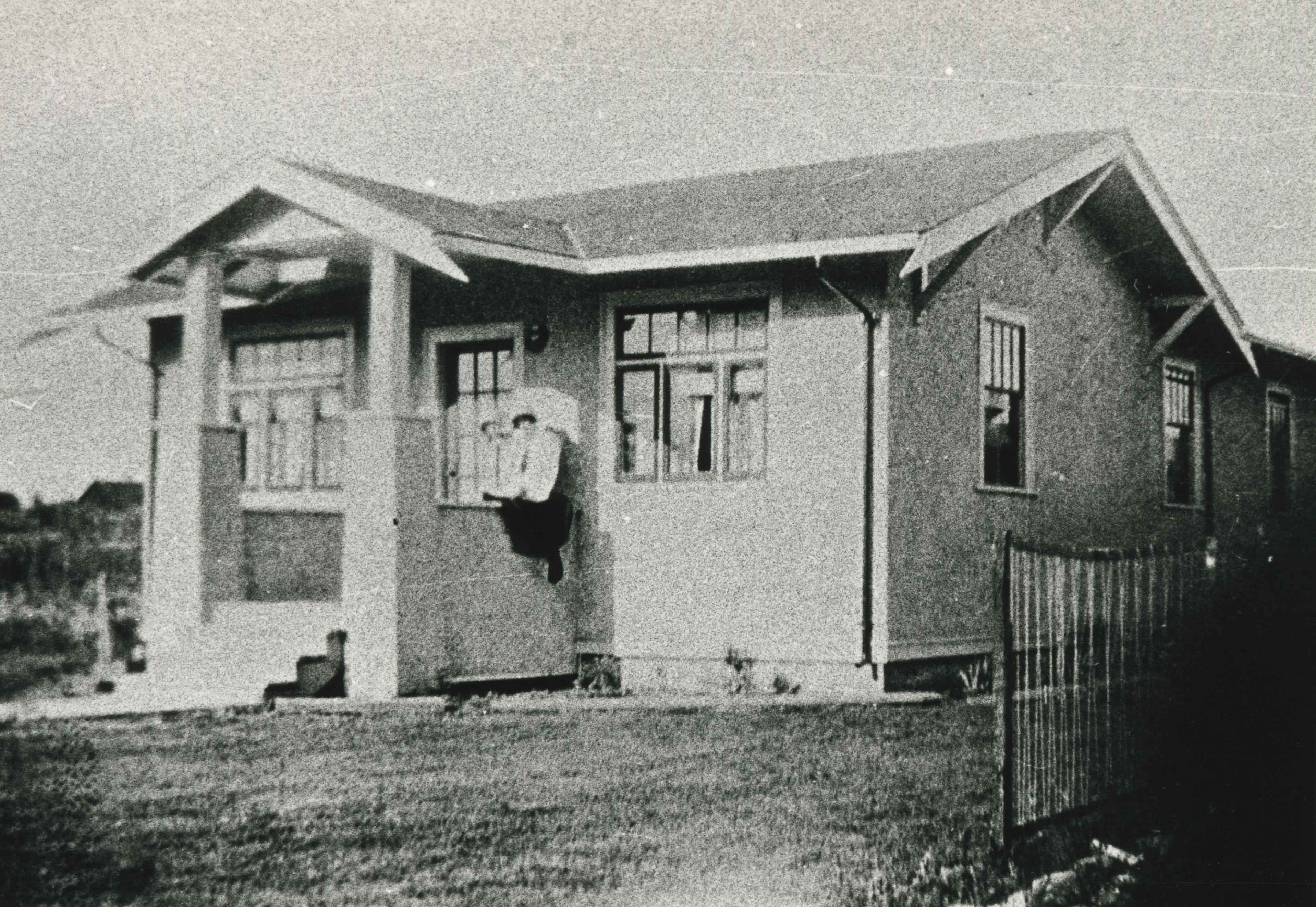
![Allanson family home, [192-] (date of original), copied 1986 thumbnail](/media/hpo/_Data/_Archives_Images/_Unrestricted/204/204-652.jpg?width=280)
Allanson family home
https://search.heritageburnaby.ca/link/archivedescription35794
- Repository
- City of Burnaby Archives
- Date
- [192-] (date of original), copied 1986
- Collection/Fonds
- Burnaby Historical Society fonds
- Description Level
- Item
- Physical Description
- 1 photograph : b&w ; 12.7 x 17.8 cm print
- Scope and Content
- Photograph of the Allanson family home, 12 Warwick Avenue, Capitol Hill, North Burnaby.
- Repository
- City of Burnaby Archives
- Date
- [192-] (date of original), copied 1986
- Collection/Fonds
- Burnaby Historical Society fonds
- Subseries
- Pioneer Tales subseries
- Physical Description
- 1 photograph : b&w ; 12.7 x 17.8 cm print
- Description Level
- Item
- Record No.
- 204-652
- Access Restriction
- No restrictions
- Reproduction Restriction
- No known restrictions
- Accession Number
- BHS1988-03
- Scope and Content
- Photograph of the Allanson family home, 12 Warwick Avenue, Capitol Hill, North Burnaby.
- Media Type
- Photograph
- Notes
- Title based on contents of photograph
- Geographic Access
- Warwick Avenue
- Street Address
- 12 Warwick Avenue
- Historic Neighbourhood
- Capitol Hill (Historic Neighbourhood)
- Planning Study Area
- Capitol Hill Area
Images
![Allanson family home, [192-] (date of original), copied 1986 thumbnail](/media/hpo/_Data/_Archives_Images/_Unrestricted/204/204-652.jpg)

Anderson family home
https://search.heritageburnaby.ca/link/archivedescription37448
- Repository
- City of Burnaby Archives
- Date
- 1962 (date of original), copied 1991
- Collection/Fonds
- Burnaby Historical Society fonds
- Description Level
- Item
- Physical Description
- 1 photograph : b&w ; 4.1 x 3.8 cm print on contact sheet 20.2 x 25.4 cm
- Scope and Content
- Photograph of the front of the Anderson family home at 3908 Norland Avenue (previously numbered 4437 Norland Avenue) in the snow.
- Repository
- City of Burnaby Archives
- Date
- 1962 (date of original), copied 1991
- Collection/Fonds
- Burnaby Historical Society fonds
- Subseries
- Burnaby Image Bank subseries
- Physical Description
- 1 photograph : b&w ; 4.1 x 3.8 cm print on contact sheet 20.2 x 25.4 cm
- Description Level
- Item
- Record No.
- 370-036
- Access Restriction
- No restrictions
- Reproduction Restriction
- No restrictions
- Accession Number
- BHS1999-03
- Scope and Content
- Photograph of the front of the Anderson family home at 3908 Norland Avenue (previously numbered 4437 Norland Avenue) in the snow.
- Media Type
- Photograph
- Notes
- Title based on contents of photograph
- 1 b&w copy negative accompanying
- Geographic Access
- Norland Avenue
- Street Address
- 3908 Norland Avenue
- Historic Neighbourhood
- Burnaby Lake (Historic Neighbourhood)
- Planning Study Area
- Douglas-Gilpin Area
Images


Armitage family home
https://search.heritageburnaby.ca/link/archivedescription35775
- Repository
- City of Burnaby Archives
- Date
- 1920 (date of original), copied 1986
- Collection/Fonds
- Burnaby Historical Society fonds
- Description Level
- Item
- Physical Description
- 1 photograph : b&w ; 12.7 x 17.8 cm print
- Scope and Content
- Photograph of the Armitage family home at 3276 Grimmer Street (later renumbered 5496 Grimmer Street), on the corner of Grimmer and Kingsway in South Burnaby. This was the second Armitage home and the second house built on this lot, the first having burned down.
- Repository
- City of Burnaby Archives
- Date
- 1920 (date of original), copied 1986
- Collection/Fonds
- Burnaby Historical Society fonds
- Subseries
- Pioneer Tales subseries
- Physical Description
- 1 photograph : b&w ; 12.7 x 17.8 cm print
- Description Level
- Item
- Record No.
- 204-633
- Access Restriction
- No restrictions
- Reproduction Restriction
- No known restrictions
- Accession Number
- BHS1988-03
- Scope and Content
- Photograph of the Armitage family home at 3276 Grimmer Street (later renumbered 5496 Grimmer Street), on the corner of Grimmer and Kingsway in South Burnaby. This was the second Armitage home and the second house built on this lot, the first having burned down.
- Subjects
- Buildings - Residential - Houses
- Media Type
- Photograph
- Notes
- Title based on contents of photograph
- Geographic Access
- Grimmer Street
- Street Address
- 5496 Grimmer Street
- Historic Neighbourhood
- Central Park (Historic Neighbourhood)
- Planning Study Area
- Windsor Area
Images

Armitage family home
https://search.heritageburnaby.ca/link/archivedescription35776
- Repository
- City of Burnaby Archives
- Date
- 1924 (date of original), copied 1986
- Collection/Fonds
- Burnaby Historical Society fonds
- Description Level
- Item
- Physical Description
- 1 photograph : b&w ; 12.7 x 17.8 cm print
- Scope and Content
- Photograph of the Armitage family home at 1925 Buller Avenue (later renumbered 7342 Buller Avenue) in the Highland Park area. This was the third Armitage home. Edna Armitage and Joe Rigby held their wedding reception here in 1931.
- Repository
- City of Burnaby Archives
- Date
- 1924 (date of original), copied 1986
- Collection/Fonds
- Burnaby Historical Society fonds
- Subseries
- Pioneer Tales subseries
- Physical Description
- 1 photograph : b&w ; 12.7 x 17.8 cm print
- Description Level
- Item
- Record No.
- 204-634
- Access Restriction
- No restrictions
- Reproduction Restriction
- No known restrictions
- Accession Number
- BHS1988-03
- Scope and Content
- Photograph of the Armitage family home at 1925 Buller Avenue (later renumbered 7342 Buller Avenue) in the Highland Park area. This was the third Armitage home. Edna Armitage and Joe Rigby held their wedding reception here in 1931.
- Subjects
- Buildings - Residential - Houses
- Media Type
- Photograph
- Notes
- Title based on contents of photograph
- Geographic Access
- Buller Avenue
- Street Address
- 7342 Buller Avenue
- Planning Study Area
- Clinton-Glenwood Area
Images
![Armitage family home, [192-] (date of original), copied 1986 thumbnail](/media/hpo/_Data/_Archives_Images/_Unrestricted/204/204-635.jpg?width=280)
Armitage family home
https://search.heritageburnaby.ca/link/archivedescription35777
- Repository
- City of Burnaby Archives
- Date
- [192-] (date of original), copied 1986
- Collection/Fonds
- Burnaby Historical Society fonds
- Description Level
- Item
- Physical Description
- 1 photograph : b&w ; 12.7 x 17.8 cm print
- Scope and Content
- Photograph of the Armitage family home at 3276 Buller Avenue (later renumbered 7342 Buller Avenue) in the Highland Park Area. This fourth Armitage family home was built by Albert Armitage and his brother. It was a much larger house than its predecessor on the same lot.
- Repository
- City of Burnaby Archives
- Date
- [192-] (date of original), copied 1986
- Collection/Fonds
- Burnaby Historical Society fonds
- Subseries
- Pioneer Tales subseries
- Physical Description
- 1 photograph : b&w ; 12.7 x 17.8 cm print
- Description Level
- Item
- Record No.
- 204-635
- Access Restriction
- No restrictions
- Reproduction Restriction
- No known restrictions
- Accession Number
- BHS1988-03
- Scope and Content
- Photograph of the Armitage family home at 3276 Buller Avenue (later renumbered 7342 Buller Avenue) in the Highland Park Area. This fourth Armitage family home was built by Albert Armitage and his brother. It was a much larger house than its predecessor on the same lot.
- Subjects
- Buildings - Residential - Houses
- Media Type
- Photograph
- Notes
- Title based on contents of photograph
- Geographic Access
- Buller Avenue
- Street Address
- 7342 Buller Avenue
- Planning Study Area
- Clinton-Glenwood Area
Images
![Armitage family home, [192-] (date of original), copied 1986 thumbnail](/media/hpo/_Data/_Archives_Images/_Unrestricted/204/204-635.jpg)