Narrow Results By
Subject
- Animals - Birds 1
- Animals - Dogs 2
- Buildings - Residential - Houses 1
- Buildings - Residential - Seniors Housing 1
- Exhibitions 1
- Geographic Features - Lakes and Ponds 6
- Geographic Features - Mountains 1
- Geographic Features - Rivers 2
- Natural Phenomena - Snow 1
- Occupations - Veterinarians 1
- Plants - Trees 1
- Structures - Dams 2

Burnaby Lake Neighbourhood
https://search.heritageburnaby.ca/link/landmark700
- Repository
- Burnaby Heritage Planning
- Associated Dates
- 1925-1954
- Heritage Value
- After World War I and the Great Depression of the 1930s, more homes were constructed and subdivisions created in the Burnaby Lake district. The area around Deer Lake gained a reputation for being an "artistic development of commodious homes with park-like grounds."
- Historic Neighbourhood
- Burnaby Lake (Historic Neighbourhood)
- Planning Study Area
- Burnaby Lake Area
Images


Burnaby Lake Neighbourhood
https://search.heritageburnaby.ca/link/landmark821
- Repository
- Burnaby Heritage Planning
- Associated Dates
- 1955-2008
- Heritage Value
- In 1966 Burnaby Lake was identified as a key potential regional park in the GVRD ’s Regional Park Plan for the Lower Mainland. The lake was to be developed for nature study, strolling, trail riding, canoeing, sightseeing and picnicking. It was formally recognized as a regional nature park in 1979, at which time the GVRD assumed management of the park through a lease agreement with the City of Burnaby. In 1993 Burnaby Lake was selected by the City of Burnaby to be included in Greater Vancouver ’s Green Zone, and was identified as a key component of the GVRD ’s Park and Outdoor Recreation System (PORS) for the Burrard/Peninsula/Richmond sector, which includes Burnaby, Vancouver, New Westminster, and Richmond.
- Historic Neighbourhood
- Burnaby Lake (Historic Neighbourhood)
- Planning Study Area
- Burnaby Lake Area
Images


Mortimer-Lamb House
https://search.heritageburnaby.ca/link/landmark494
- Repository
- Burnaby Heritage Planning
- Description
- The Mortimer-Lamb House is a one and one half-storey, Arts and Crafts-style residence with a steeply pitched, side-gabled roof. The original cottage form has been enlarged with a later addition on the west side of the house. Located next to the Burnaby Lake Regional Park Wildlife Rescue Care Centre…
- Associated Dates
- c.1922
- Formal Recognition
- Community Heritage Register
- Other Names
- Harold & Katherine Mortimer-Lamb Residence
- Street View URL
- Google Maps Street View
- Repository
- Burnaby Heritage Planning
- Other Names
- Harold & Katherine Mortimer-Lamb Residence
- Geographic Access
- Glencarin Drive
- Associated Dates
- c.1922
- Formal Recognition
- Community Heritage Register
- Enactment Type
- Council Resolution
- Enactment Date
- 26/05/2003
- Description
- The Mortimer-Lamb House is a one and one half-storey, Arts and Crafts-style residence with a steeply pitched, side-gabled roof. The original cottage form has been enlarged with a later addition on the west side of the house. Located next to the Burnaby Lake Regional Park Wildlife Rescue Care Centre, the house has picturesque views of Burnaby Lake.
- Heritage Value
- Built circa 1922, the Mortimer-Lamb House is valued for its association with first owners, Harold Mortimer-Lamb (1872-1970), and his wife, Katherine Mary Mortimer-Lamb (1873-1939). Born in Leatherhead, Surrey, England, Harold Mortimer-Lamb immigrated to Canada in 1889. Seven years later in Vancouver, he married Katherine Mary Lindsay, a native of Winnipeg. Mortimer-Lamb was a key figure in the B.C. mining industry, serving as Secretary of the Mining Association of B.C. between 1900 and 1945, and also as the Secretary of the Canadian Institute of Mining and Metallurgy. In addition to his professional life, Mortimer-Lamb was a pioneer art photographer and was among Canada's leading art critics, and this house served as a central gathering place for renowned Canadian artists of the day. Mortimer-Lamb’s daughter, Molly Lamb Bobak (born 1922), became a renowned watercolourist, and was the only woman ever hired as an official Canadian war artist. The Mortimer-Lamb House is a significant example of the work of noted architect, Samuel Maclure (1860-1929) and his partner, Ross Lort (1889-1969). Maclure, who was a close friend of the Mortimer-Lamb family, was British Columbia's leading residential architect, and was renowned for his high quality designs for prominent citizens in both Vancouver and Victoria. Maclure was a leading exponent of the Art and Crafts design movement in B.C., and established a sophisticated local variation of residential architecture. The Mortimer-Lamb House was designed at the time when Maclure was in partnership with Ross Lort. In 1907, Lort began working for Maclure's firm as a draftsman, and by 1920 was in charge of Maclure's Vancouver office. Lort's architectural career spanned some sixty-years, and he designed some of the province's most familiar houses, apartments, institutions and places of worship. The Mortimer-Lamb House is also a significant local example of the Arts and Crafts style, and incorporates elements such as board-and-batten siding on the ground floor, shingled gables and leaded casement windows. It is a testament to the domestic architecture built outside of established suburbs during the post-First World War era, typically modest in scale and representative of middle-class residential ideals.
- Defining Elements
- Key elements that define the heritage character of the Mortimer-Lamb House include its: - treed setting with views of Burnaby Lake - residential form, scale and massing as expressed by its one and one-half storey height, rectangular plan and steeply pitched side-gabled roof - wood-frame construction - Arts and Crafts elements such as board-and-batten siding on the ground floor, cedar shingles in the gables and open soffits - original straight-leaded casement windows in single and multiple-assembly - internal red-brick chimney with corbelled cap
- Historic Neighbourhood
- Burnaby Lake (Historic Neighbourhood)
- Planning Study Area
- Burnaby Lake Area
- Organization
- Mining Association of B.C.
- G.F. and J. Galt Limited
- Architect
- Samuel Maclure
- Ross Lort
- Function
- Primary Historic--Single Dwelling
- Primary Current--Single Dwelling
- Community
- Burnaby Lake
- Cadastral Identifier
- P.I.D.002-977-788
- Boundaries
- The Mortimer-Lamb House is comprised of a single residential lot located at 5180 Glencairn Drive, Burnaby.
- Area
- 5652.78
- Contributing Resource
- Building
- Ownership
- Private
- Documentation
- City of Burnaby Planning and Building Department, Heritage Site Files
- Street Address
- 5180 Glencarin Drive
- Street View URL
- Google Maps Street View
Images


Stanley & Isabel Picken House 'Aintree'
https://search.heritageburnaby.ca/link/landmark519
- Repository
- Burnaby Heritage Planning
- Description
- Nestled within a stand of deciduous trees, the Stanley and Isabel Picken House 'Aintree' is a two and one-half storey plus basement shingled and half-timbered Arts and Crafts influenced residence, set on its original 0.6 hectare site adjacent to Brunette Creek in the Burnaby Lake Regional Nature Pa…
- Associated Dates
- 1929
- Formal Recognition
- Heritage Designation, Community Heritage Register
- Street View URL
- Google Maps Street View
- Repository
- Burnaby Heritage Planning
- Geographic Access
- Cariboo Road
- Associated Dates
- 1929
- Formal Recognition
- Heritage Designation, Community Heritage Register
- Enactment Type
- Bylaw No. 11756
- Enactment Date
- 09/08//2004
- Description
- Nestled within a stand of deciduous trees, the Stanley and Isabel Picken House 'Aintree' is a two and one-half storey plus basement shingled and half-timbered Arts and Crafts influenced residence, set on its original 0.6 hectare site adjacent to Brunette Creek in the Burnaby Lake Regional Nature Park.
- Heritage Value
- 'Aintree' is an example of the type of private country estate residences built in Burnaby outside of the established suburbs during the 1920s, and is representative of middle-class residential life during this time. Stanley Boyd Picken (1890-1950) and Isabel Grace Frederique Picken (1893-1971) purchased this property in 1927 to establish the Aintree Dog Kennels, which was the first in the province to breed Irish Setters. This country residence was completed in 1929. Stanley Picken worked at a variety of other jobs including his position as keeper of the Brunette River Caribou Dam. Considered a fine example of romantic architecture, 'Aintree' stands in harmony with its woodland setting. The north wing was added in a compatible style in 1932 using former bridge support beams from the old Caribou Road Bridge for foundation support. 'Aintree' retains most of its original exterior elements including its picturesque shingled siding and half-timbering, demonstrating the late influence of an Arts and Crafts sensibility considered compatible with a country lifestyle.
- Defining Elements
- Key elements that define the heritage character of 'Aintree' include its: - woodland setting adjacent to Brunette Creek in the Burnaby Lake Regional Nature Park, with a deep setback from Cariboo Road - residential form, scale and massing as exemplified by its asymmetrical two and one-half storey plus basement height and irregular U-shaped plan - romantic Arts and Crafts influence as expressed in elements such as half-timbering on the upper storeys and hand-split cedar shake wall cladding - steeply pitched cross-gabled roofs with dormers connected by a lower central gabled roof, and 'cat slide' extension over side entry - regular fenestration, including wooden-sash casement windows with diamond leaded glass - red brick internal chimney with corbelled cap - associated landscape features, such as a curving driveway leading to the house, an early garage, grassed yard and a backdrop of mature deciduous trees
- Historic Neighbourhood
- Burquitlam (Historic Neighbourhood)
- Planning Study Area
- Burnaby Lake Area
- Function
- Primary Historic--Single Dwelling
- Community
- Burnaby
- Cadastral Identifier
- 010-867-147
- Boundaries
- 'Aintree' is comprised of a single residential lot located at 6825 Cariboo Road, Burnaby.
- Area
- 5436.75
- Contributing Resource
- Building
- Ownership
- Private
- Names
- Picken, Stanley
- Street Address
- 6825 Cariboo Road
- Street View URL
- Google Maps Street View
Images


Bob and Robert Peers at Burnaby Lake
https://search.heritageburnaby.ca/link/archivedescription38940
- Repository
- City of Burnaby Archives
- Date
- 1927
- Collection/Fonds
- Peers Family and Hill Family fonds
- Description Level
- Item
- Physical Description
- 1 photograph : sepia ; 6 x 10.5 cm on page 13.5 x 18.5 cm (pasted in album)
- Scope and Content
- Photograph of Bob Peers and his son, Robert outside a home identified by a caption as being at "Burnaby Lake." This likely refers to the Bob and Kitty Peers home in the Burnaby Lake area, on Deer Lake Avenue.
- Repository
- City of Burnaby Archives
- Date
- 1927
- Collection/Fonds
- Peers Family and Hill Family fonds
- Physical Description
- 1 photograph : sepia ; 6 x 10.5 cm on page 13.5 x 18.5 cm (pasted in album)
- Description Level
- Item
- Record No.
- 477-259
- Access Restriction
- No restrictions
- Reproduction Restriction
- No known restrictions
- Accession Number
- 2007-12
- Scope and Content
- Photograph of Bob Peers and his son, Robert outside a home identified by a caption as being at "Burnaby Lake." This likely refers to the Bob and Kitty Peers home in the Burnaby Lake area, on Deer Lake Avenue.
- Media Type
- Photograph
- Notes
- Title based on caption accompanying photograph
- Geographic Access
- Deer Lake Avenue
- Street Address
- 6588 Deer Lake Avenue
- Historic Neighbourhood
- Burnaby Lake (Historic Neighbourhood)
- Planning Study Area
- Douglas-Gilpin Area
Images
Claude and Annie Hill's house
https://search.heritageburnaby.ca/link/archivedescription39222
- Repository
- City of Burnaby Archives
- Date
- 1923
- Collection/Fonds
- Peers Family and Hill Family fonds
- Description Level
- Item
- Physical Description
- 1 photograph : sepia ; 6.7 x 10.3 cm on page 24.5 x 32.5 cm (pasted in album)
- Scope and Content
- Photograph of Claude and Annie Hill's house. This was the third home the Hill's lived in that was in the Burnaby Lake area, the first two being known as Brookfield and Broadview.
- Repository
- City of Burnaby Archives
- Date
- 1923
- Collection/Fonds
- Peers Family and Hill Family fonds
- Physical Description
- 1 photograph : sepia ; 6.7 x 10.3 cm on page 24.5 x 32.5 cm (pasted in album)
- Description Level
- Item
- Record No.
- 477-541
- Access Restriction
- No restrictions
- Reproduction Restriction
- No known restrictions
- Accession Number
- 2007-12
- Scope and Content
- Photograph of Claude and Annie Hill's house. This was the third home the Hill's lived in that was in the Burnaby Lake area, the first two being known as Brookfield and Broadview.
- Subjects
- Buildings - Residential - Houses
- Media Type
- Photograph
- Notes
- Title based on caption accompanying photograph
- Geographic Access
- Deer Lake Avenue
- Street Address
- 6570 Deer Lake Avenue
- Historic Neighbourhood
- Burnaby Lake (Historic Neighbourhood)
- Planning Study Area
- Douglas-Gilpin Area
Images
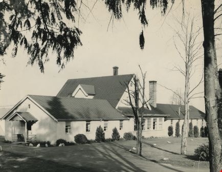
Dania Home
https://search.heritageburnaby.ca/link/archivedescription34585
- Repository
- City of Burnaby Archives
- Date
- 1958
- Collection/Fonds
- Burnaby Historical Society fonds
- Description Level
- Item
- Physical Description
- 1 photograph : b&w ; 17.8 x 22.7 cm
- Scope and Content
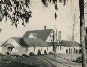
- Photograph of the exterior of the Dania Home at 4279 Norland Avenue and Canada Way. The accompanying description reads, "Dania - Modern Danish Rest Home / On site pioneer estate of C.F. Sprott, one of first reeves of Burnaby, Douglas Road - near Norland." The original house, at the centre of the b…
- Repository
- City of Burnaby Archives
- Date
- 1958
- Collection/Fonds
- Burnaby Historical Society fonds
- Subseries
- Photographs subseries
- Physical Description
- 1 photograph : b&w ; 17.8 x 22.7 cm
- Description Level
- Item
- Record No.
- 059-001
- Access Restriction
- No restrictions
- Reproduction Restriction
- Reproduce for fair dealing purposes only
- Accession Number
- BHS2007-04
- Scope and Content
- Photograph of the exterior of the Dania Home at 4279 Norland Avenue and Canada Way. The accompanying description reads, "Dania - Modern Danish Rest Home / On site pioneer estate of C.F. Sprott, one of first reeves of Burnaby, Douglas Road - near Norland." The original house, at the centre of the building, was one of the earliest homes in the Burnaby Lake area, built in 1891 by Charles F. Sprott with the assistance of Bernard R. Hill.
- Names
- Dania Home
- Media Type
- Photograph
- Notes
- Title based on contents of photograph
- Geographic Access
- Norland Avenue
- Street Address
- 4279 Norland Avenue
- Historic Neighbourhood
- Burnaby Lake (Historic Neighbourhood)
- Planning Study Area
- Douglas-Gilpin Area
Images
Interview with Bob Lowe 2005 - Track 6
https://search.heritageburnaby.ca/link/museumdescription4498
- Repository
- Burnaby Village Museum
- Date
- 1930-1949 (interview content), interviewed May 2005
- Collection/Fonds
- Burnaby Village Museum fonds
- Description Level
- Item
- Physical Description
- 1 sound recording (mp3) (0:05:45 min)
- Scope and Content
- Track 6: This portion of the recording pertains to Bob’s feelings about Burnaby as a place to live, and continues the subject of change. Bob talks of his property in Burnaby, which he purchased as acreage. He compares the Burnaby of his childhood to that of pioneers such as Tommy Irvine, describing…
- Repository
- Burnaby Village Museum
- Collection/Fonds
- Burnaby Village Museum fonds
- Series
- Museum Oral Histories series
- Subseries
- Growing Up in Burnaby subseries
- Description Level
- Item
- Physical Description
- 1 sound recording (mp3) (0:05:45 min)
- Material Details
- Interviewer: Tom Gooden Interviewee: Bob Lowe Date of interview: May 2005 Total Number of Tracks: 6 Total length of all Tracks: 0:43:36
- Scope and Content
- Track 6: This portion of the recording pertains to Bob’s feelings about Burnaby as a place to live, and continues the subject of change. Bob talks of his property in Burnaby, which he purchased as acreage. He compares the Burnaby of his childhood to that of pioneers such as Tommy Irvine, describing himself as a relative newcomer. He speaks of the preservation of the Deer Lake and Burnaby Lake areas. Bob describes his disorientation in the more newly densified parts of Burnaby, and observes that traffic has increased on Burnaby streets. Bob recalls that he mostly travelled on foot or by bike. He notes that the Neville Transport Company operated the school bus he used as well as the only North-South bus route in Burnaby at that time. He mentions Pacific Stage Lines as a later operator through Burnaby.
- History
- Recording of an interview with Bob Lowe recording by Tom Gooden in 2005. This recording was completed for an exhibit, Growing Up in Burnaby, for the Burnaby Village Museum. Major themes discussed are growing up in Burnaby in the 1930s and 40s.
- Creator
- Burnaby Village Museum
- Geographic Access
- Burnaby Lake
- Deer Lake
- Accession Code
- BV017.45.6
- Access Restriction
- No restrictions
- Reproduction Restriction
- May be restricted by third party rights
- Date
- 1930-1949 (interview content), interviewed May 2005
- Media Type
- Sound Recording
- Notes
- Tiltle based on cotents of item
Audio Tracks
Interview with Bob Lowe 2005 - Track 6, 1930-1949 (interview content), interviewed May 2005
Interview with Bob Lowe 2005 - Track 6, 1930-1949 (interview content), interviewed May 2005
https://search.heritageburnaby.ca/media/hpo/_Data/_BVM_Sound_Recordings/Oral_Histories/2017_0045_0006_006.mp3
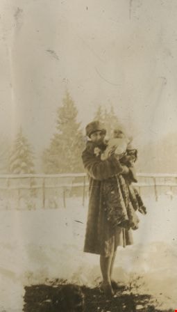
Kitty and Robert
https://search.heritageburnaby.ca/link/archivedescription38946
- Repository
- City of Burnaby Archives
- Date
- December 1927
- Collection/Fonds
- Peers Family and Hill Family fonds
- Description Level
- Item
- Physical Description
- 1 photograph : b&w ; 6 x 10.5 cm on page 13.5 x 18.5 cm (pasted in album)
- Scope and Content
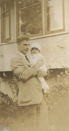
- Photograph of Kitty Peers holding her son Robert, aged nine months. This photograph was taken in December, 1927 in the Burnaby Lake area - note the snow on the ground.
- Repository
- City of Burnaby Archives
- Date
- December 1927
- Collection/Fonds
- Peers Family and Hill Family fonds
- Physical Description
- 1 photograph : b&w ; 6 x 10.5 cm on page 13.5 x 18.5 cm (pasted in album)
- Description Level
- Item
- Record No.
- 477-265
- Access Restriction
- No restrictions
- Reproduction Restriction
- No known restrictions
- Accession Number
- 2007-12
- Scope and Content
- Photograph of Kitty Peers holding her son Robert, aged nine months. This photograph was taken in December, 1927 in the Burnaby Lake area - note the snow on the ground.
- Media Type
- Photograph
- Notes
- Title based on caption accompanying photograph
- Historic Neighbourhood
- Burnaby Lake (Historic Neighbourhood)
- Planning Study Area
- Morley-Buckingham Area
Images
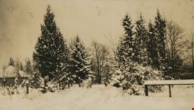
Trees and in the snow
https://search.heritageburnaby.ca/link/archivedescription39308
- Repository
- City of Burnaby Archives
- Date
- 1922
- Collection/Fonds
- Peers Family and Hill Family fonds
- Description Level
- Item
- Physical Description
- 1 photograph : b&w ; 6 x 10.4 cm on page 24.5 x 32.5 cm (pasted in album)
- Scope and Content
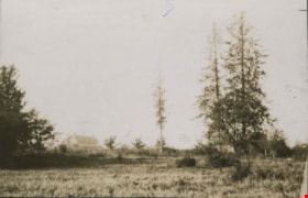
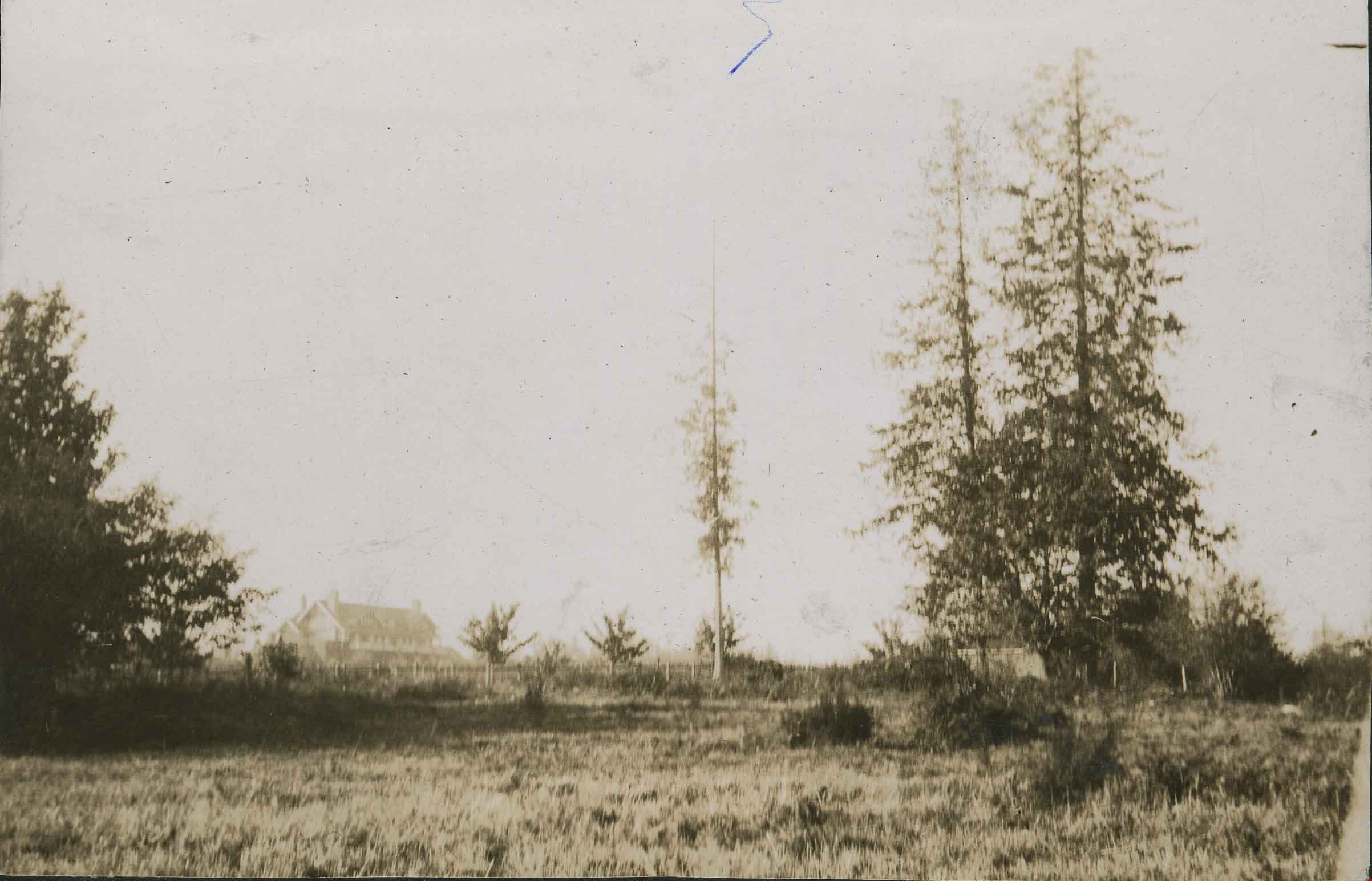
- Photograph of a field and trees covered in snow. This photograph was probably taken at Broadview, the home of Claude Hill and his family in the Burnaby Lake area.
- Repository
- City of Burnaby Archives
- Date
- 1922
- Collection/Fonds
- Peers Family and Hill Family fonds
- Physical Description
- 1 photograph : b&w ; 6 x 10.4 cm on page 24.5 x 32.5 cm (pasted in album)
- Description Level
- Item
- Record No.
- 477-627
- Access Restriction
- No restrictions
- Reproduction Restriction
- No known restrictions
- Accession Number
- 2007-12
- Scope and Content
- Photograph of a field and trees covered in snow. This photograph was probably taken at Broadview, the home of Claude Hill and his family in the Burnaby Lake area.
- Subjects
- Natural Phenomena - Snow
- Plants - Trees
- Media Type
- Photograph
- Notes
- Title based on contents of photograph
- Geographic Access
- Buckingham Avenue
- Street Address
- 5730 Buckingham Avenue
- Historic Neighbourhood
- Burnaby Lake (Historic Neighbourhood)
- Planning Study Area
- Morley-Buckingham Area
Images

![Boal family home, [1950] thumbnail](/media/hpo/_Data/_BVM_Images/2017/201700280022_001.jpg?width=280)
Boal family home
https://search.heritageburnaby.ca/link/museumdescription4215
- Repository
- Burnaby Village Museum
- Date
- [1950]
- Collection/Fonds
- Burnaby Village Museum Photograph collection
- Description Level
- Item
- Physical Description
- 1 photograph : b&w ; 6.5 x 9 cm
- Scope and Content
- Photograph of the Boal home at 4319 Norland Ave in Burnaby. This is a three-quarter shot of the house which has new, light coloured siding (white?) and a garage in the back. A man is mowing the lawn next to the house.
- Repository
- Burnaby Village Museum
- Collection/Fonds
- Burnaby Village Museum Photograph collection
- Description Level
- Item
- Physical Description
- 1 photograph : b&w ; 6.5 x 9 cm
- Material Details
- Handwritten text in ink on front of photograph reads: "1950".
- Stamped numeral on back of photograph reads: "452".
- Handwritten text on back of photograph reads: "summer, 1950 / Boals' house".
- Scope and Content
- Photograph of the Boal home at 4319 Norland Ave in Burnaby. This is a three-quarter shot of the house which has new, light coloured siding (white?) and a garage in the back. A man is mowing the lawn next to the house.
- History
- Material belonged to Glen and Ann Boal (nee Lockhart), who grew up in Burnaby and attended Burnaby South High School. They met and became engaged and married in 1954.
- Geographic Access
- Norland Avenue
- Street Address
- 4319 Norland Avenue
- Accession Code
- BV017.28.22
- Access Restriction
- No restrictions
- Reproduction Restriction
- No known restrictions
- Date
- [1950]
- Media Type
- Photograph
- Historic Neighbourhood
- Burnaby Lake (Historic Neighbourhood)
- Planning Study Area
- Burnaby Lake Area
- Scan Resolution
- 600
- Scan Date
- 06-Mar-2018
- Notes
- Title based on contents of photograph
Images
![Boal family home, [1950] thumbnail](/media/hpo/_Data/_BVM_Images/2017/201700280022_001.jpg)
![Boal family home, [195-] thumbnail](/media/hpo/_Data/_BVM_Images/2017/201700280023_001.jpg?width=280)
Boal family home
https://search.heritageburnaby.ca/link/museumdescription4216
- Repository
- Burnaby Village Museum
- Date
- [195-]
- Collection/Fonds
- Burnaby Village Museum Photograph collection
- Description Level
- Item
- Physical Description
- 1 photograph : col. ; 9 x 13 cm
- Scope and Content
- Photograph of the Boal home at 4319 Norland Ave in Burnaby. This is a three-quarter shot of the house. The house has been altered by enclosing the front porch and lowering the front door to ground level. Doors and window sills are painted light blue. Window shutters have been added. The house is wh…
- Repository
- Burnaby Village Museum
- Collection/Fonds
- Burnaby Village Museum Photograph collection
- Description Level
- Item
- Physical Description
- 1 photograph : col. ; 9 x 13 cm
- Scope and Content
- Photograph of the Boal home at 4319 Norland Ave in Burnaby. This is a three-quarter shot of the house. The house has been altered by enclosing the front porch and lowering the front door to ground level. Doors and window sills are painted light blue. Window shutters have been added. The house is white. There are trees in full leaf around the house.
- History
- Material belonged to Glen and Ann Boal (nee Lockhart), who grew up in Burnaby and attended Burnaby South High School. They met and became engaged and married in 1954.
- Geographic Access
- Norland Avenue
- Street Address
- 4319 Norland Avenue
- Accession Code
- BV017.28.23
- Access Restriction
- No restrictions
- Reproduction Restriction
- No known restrictions
- Date
- [195-]
- Media Type
- Photograph
- Historic Neighbourhood
- Burnaby Lake (Historic Neighbourhood)
- Planning Study Area
- Burnaby Lake Area
- Scan Resolution
- 600
- Scan Date
- 06-Mar-2018
- Notes
- Title based on contents of photograph
Images
![Boal family home, [195-] thumbnail](/media/hpo/_Data/_BVM_Images/2017/201700280023_001.jpg)

Burnaby Lake
https://search.heritageburnaby.ca/link/archivedescription34563
- Repository
- City of Burnaby Archives
- Date
- 1923
- Collection/Fonds
- Burnaby Historical Society fonds
- Description Level
- Item
- Physical Description
- 1 photograph : b&w ; 17.4 x 35.3 cm
- Scope and Content
- Photograph of Burnaby Lake, looking northwest. The north shore mountains, including The Lions, can be seen in the background.
- Repository
- City of Burnaby Archives
- Date
- 1923
- Collection/Fonds
- Burnaby Historical Society fonds
- Subseries
- Photographs subseries
- Physical Description
- 1 photograph : b&w ; 17.4 x 35.3 cm
- Description Level
- Item
- Record No.
- 050-001
- Access Restriction
- No restrictions
- Reproduction Restriction
- No known restrictions
- Accession Number
- BHS2007-04
- Scope and Content
- Photograph of Burnaby Lake, looking northwest. The north shore mountains, including The Lions, can be seen in the background.
- Media Type
- Photograph
- Notes
- Title based on contents of photograph
- Geographic Access
- Burnaby Lake
- Historic Neighbourhood
- Burnaby Lake (Historic Neighbourhood)
- Planning Study Area
- Burnaby Lake Area
Images

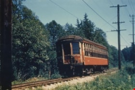
Burnaby Lake Tram #1228
https://search.heritageburnaby.ca/link/archivedescription35991
- Repository
- City of Burnaby Archives
- Date
- June 1951
- Collection/Fonds
- Burnaby Historical Society fonds
- Description Level
- Item
- Physical Description
- 1 photograph : col. ; 10 x 15 cm print
- Scope and Content
- Photograph of Tram #1228 on the Burnaby Lake Interurban line, near Stormont station.
- Repository
- City of Burnaby Archives
- Date
- June 1951
- Collection/Fonds
- Burnaby Historical Society fonds
- Subseries
- Geoff Meugans subseries
- Physical Description
- 1 photograph : col. ; 10 x 15 cm print
- Description Level
- Item
- Record No.
- 208-002
- Access Restriction
- No restrictions
- Reproduction Restriction
- Reproduce for fair dealing purposes only
- Accession Number
- BHS1988-08
- Scope and Content
- Photograph of Tram #1228 on the Burnaby Lake Interurban line, near Stormont station.
- Subjects
- Transportation - Electric Railroads
- Media Type
- Photograph
- Notes
- Title based on contents of photograph
- Geographic Access
- Burnaby Lake Interurban line
- Planning Study Area
- Burnaby Lake Area
Images

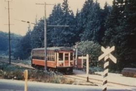
Burnaby Lake Tram #1230
https://search.heritageburnaby.ca/link/archivedescription35996
- Repository
- City of Burnaby Archives
- Date
- August 1951
- Collection/Fonds
- Burnaby Historical Society fonds
- Description Level
- Item
- Physical Description
- 1 photograph : col. ; 10 x 15 cm print
- Scope and Content
- Photograph of Tram #1230 on the Burnaby Lake Interurban line, at Cariboo station's level crossing.
- Repository
- City of Burnaby Archives
- Date
- August 1951
- Collection/Fonds
- Burnaby Historical Society fonds
- Subseries
- Geoff Meugans subseries
- Physical Description
- 1 photograph : col. ; 10 x 15 cm print
- Description Level
- Item
- Record No.
- 208-007
- Access Restriction
- No restrictions
- Reproduction Restriction
- Reproduce for fair dealing purposes only
- Accession Number
- BHS1988-08
- Scope and Content
- Photograph of Tram #1230 on the Burnaby Lake Interurban line, at Cariboo station's level crossing.
- Media Type
- Photograph
- Notes
- Title based on contents of photograph
- Geographic Access
- Burnaby Lake Interurban line
- Planning Study Area
- Burnaby Lake Area
Images

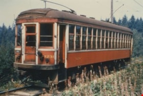
Burnaby Lake Tram #1231
https://search.heritageburnaby.ca/link/archivedescription35994
- Repository
- City of Burnaby Archives
- Date
- August 1951
- Collection/Fonds
- Burnaby Historical Society fonds
- Description Level
- Item
- Physical Description
- 1 photograph : col. ; 10 x 15 cm print
- Scope and Content
- Photograph of Tram #1231 on the Burnaby Lake Interurban line, near Stormont station.
- Repository
- City of Burnaby Archives
- Date
- August 1951
- Collection/Fonds
- Burnaby Historical Society fonds
- Subseries
- Geoff Meugans subseries
- Physical Description
- 1 photograph : col. ; 10 x 15 cm print
- Description Level
- Item
- Record No.
- 208-005
- Access Restriction
- No restrictions
- Reproduction Restriction
- Reproduce for fair dealing purposes only
- Accession Number
- BHS1988-08
- Scope and Content
- Photograph of Tram #1231 on the Burnaby Lake Interurban line, near Stormont station.
- Subjects
- Transportation - Electric Railroads
- Media Type
- Photograph
- Notes
- Title based on contents of photograph
- Geographic Access
- Burnaby Lake Interurban line
- Planning Study Area
- Burnaby Lake Area
Images

Burnaby Lake Tram #1233
https://search.heritageburnaby.ca/link/archivedescription35992
- Repository
- City of Burnaby Archives
- Date
- June 1951
- Collection/Fonds
- Burnaby Historical Society fonds
- Description Level
- Item
- Physical Description
- 1 photograph : col. ; 10 x 15 cm print
- Scope and Content
- Photograph of the caboose of Tram #1233, on the Burnaby Lake Interurban line, near Cariboo station.
- Repository
- City of Burnaby Archives
- Date
- June 1951
- Collection/Fonds
- Burnaby Historical Society fonds
- Subseries
- Geoff Meugans subseries
- Physical Description
- 1 photograph : col. ; 10 x 15 cm print
- Description Level
- Item
- Record No.
- 208-003
- Access Restriction
- No restrictions
- Reproduction Restriction
- Reproduce for fair dealing purposes only
- Accession Number
- BHS1988-08
- Scope and Content
- Photograph of the caboose of Tram #1233, on the Burnaby Lake Interurban line, near Cariboo station.
- Subjects
- Transportation - Electric Railroads
- Media Type
- Photograph
- Notes
- Title based on contents of photograph
- Geographic Access
- Burnaby Lake Interurban line
- Planning Study Area
- Burnaby Lake Area
Images


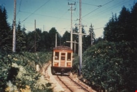
Burnaby Lake Tram #1234
https://search.heritageburnaby.ca/link/archivedescription35990
- Repository
- City of Burnaby Archives
- Date
- May 1951
- Collection/Fonds
- Burnaby Historical Society fonds
- Description Level
- Item
- Physical Description
- 1 photograph : col. ; 10 x 15 cm print
- Scope and Content
- Photograph of Tram #1234 on the Burnaby Lake Interurban line, near Stormont station.
- Repository
- City of Burnaby Archives
- Date
- May 1951
- Collection/Fonds
- Burnaby Historical Society fonds
- Subseries
- Geoff Meugans subseries
- Physical Description
- 1 photograph : col. ; 10 x 15 cm print
- Description Level
- Item
- Record No.
- 208-001
- Access Restriction
- No restrictions
- Reproduction Restriction
- Reproduce for fair dealing purposes only
- Accession Number
- BHS1988-08
- Scope and Content
- Photograph of Tram #1234 on the Burnaby Lake Interurban line, near Stormont station.
- Subjects
- Transportation - Electric Railroads
- Media Type
- Photograph
- Notes
- Title based on contents of photograph
- Geographic Access
- Burnaby Lake Interurban line
- Planning Study Area
- Burnaby Lake Area
Images
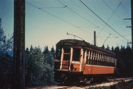
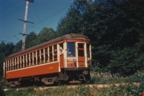
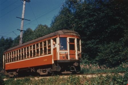
Burnaby Lake Tram #1235
https://search.heritageburnaby.ca/link/archivedescription35993
- Repository
- City of Burnaby Archives
- Date
- July 1951
- Collection/Fonds
- Burnaby Historical Society fonds
- Description Level
- Item
- Physical Description
- 1 photograph : col. ; 10 x 15 cm print
- Scope and Content
- Photograph of Tram #1235 on the Burnaby Lake Interurban line, near Cumberland Road station. The tram conductor can be seen poking his head out of the side door as he drives.
- Repository
- City of Burnaby Archives
- Date
- July 1951
- Collection/Fonds
- Burnaby Historical Society fonds
- Subseries
- Geoff Meugans subseries
- Physical Description
- 1 photograph : col. ; 10 x 15 cm print
- Description Level
- Item
- Record No.
- 208-004
- Access Restriction
- No restrictions
- Reproduction Restriction
- Reproduce for fair dealing purposes only
- Accession Number
- BHS1988-08
- Scope and Content
- Photograph of Tram #1235 on the Burnaby Lake Interurban line, near Cumberland Road station. The tram conductor can be seen poking his head out of the side door as he drives.
- Subjects
- Transportation - Electric Railroads
- Media Type
- Photograph
- Notes
- Title based on contents of photograph
- Geographic Access
- Burnaby Lake Interurban line
- Planning Study Area
- Burnaby Lake Area
Images
![Channel after dredging operation, 1951 (date of original), copied [1985] thumbnail](/media/hpo/_Data/_BVM_Images/1985/1985_0457_0007_001.jpg?width=280)
Channel after dredging operation
https://search.heritageburnaby.ca/link/museumdescription10588
- Repository
- Burnaby Village Museum
- Date
- 1951 (date of original), copied [1985]
- Collection/Fonds
- Burnaby Village Museum Photograph collection
- Description Level
- Item
- Physical Description
- 1 photograph : b&w copy negative ; 10 x 12.5 cm
- Scope and Content
- Photograph of channel of Burnaby Lake after dredging operation, 1951.
- Repository
- Burnaby Village Museum
- Collection/Fonds
- Burnaby Village Museum Photograph collection
- Description Level
- Item
- Physical Description
- 1 photograph : b&w copy negative ; 10 x 12.5 cm
- Scope and Content
- Photograph of channel of Burnaby Lake after dredging operation, 1951.
- Accession Code
- BV985.457.7
- Access Restriction
- No restrictions
- Reproduction Restriction
- May be restricted by third party rights
- Date
- 1951 (date of original), copied [1985]
- Media Type
- Photograph
- Historic Neighbourhood
- Burnaby Lake (Historic Neighbourhood)
- Planning Study Area
- Burnaby Lake Area
- Scan Resolution
- 1200
- Scan Date
- 2022-06-07
- Notes
- Title based on contents of photograph
Images
![Channel after dredging operation, 1951 (date of original), copied [1985] thumbnail](/media/hpo/_Data/_BVM_Images/1985/1985_0457_0007_001.jpg)