Narrow Results By

Daniel & Amelia Mowat House
https://search.heritageburnaby.ca/link/landmark570
- Repository
- Burnaby Heritage Planning
- Description
- Residential building.
- Associated Dates
- 1913
- Formal Recognition
- Heritage Designation, Community Heritage Register
- Street View URL
- Google Maps Street View
- Repository
- Burnaby Heritage Planning
- Geographic Access
- Beresford Street
- McKay Avenue
- Associated Dates
- 1913
- Formal Recognition
- Heritage Designation, Community Heritage Register
- Enactment Type
- Bylaw No. 13058
- Enactment Date
- 12/03/2012
- Description
- Residential building.
- Heritage Value
- This home was built by Daniel Mowat (1848-1923) and Amelia Mary Mowat (née Hoy, 1848-1923). Daniel originally worked as a merchant, and was operating a chicken farm at this location as early as 1908, and later a goat ranch. It is one of Burnaby’s few two-storey Arts and Crafts residences. The generous proportions of the house, its broad, medium-pitched, front-gabled roof and symmetrical design serve as further features. Additionally, the house boasts a high degree of integrity, retaining its original shingle wall cladding, half-timbered gables and original windows – a combination of casement windows with stained glass transoms and double-hung windows with square, multi-paned upper sashes.This house is located adjacent to what was once the Central Park interurban rail line, operated by the B.C. Electric Company, which conveniently connected this area of Burnaby to Vancouver. The arrival of this commuter line in 1892 led to the suburban development of this area of Burnaby.
- Locality
- Central Park
- Historic Neighbourhood
- Central Park (Historic Neighbourhood)
- Planning Study Area
- Maywood Area
- Contributing Resource
- Building
- Ownership
- Private
- Street Address
- 6368 McKay Avenue
- Street View URL
- Google Maps Street View
Images

Interview with Rick Sporns by Kathy Bossort October 30, 2015 - Track 4
https://search.heritageburnaby.ca/link/oralhistory606
- Repository
- City of Burnaby Archives
- Date Range
- 1900-2015
- Length
- 0:17:11
- Summary
- This portion of the interview is about Rick Sporn’s discussion of the value of natural areas to Burnaby, the city’s history of protecting green spaces, and the complementary role the Pavilion area plays in the Burnaby Mountain Conservation Area. He talks about how the rose garden and “Playground of…
- Repository
- City of Burnaby Archives
- Summary
- This portion of the interview is about Rick Sporn’s discussion of the value of natural areas to Burnaby, the city’s history of protecting green spaces, and the complementary role the Pavilion area plays in the Burnaby Mountain Conservation Area. He talks about how the rose garden and “Playground of the Gods” sculptures (Kamui Mintara) help Pavilion area visitors more fully appreciate the mountain setting. He also talks about the history of the construction of the Kamui Mintara sculptures.
- Date Range
- 1900-2015
- Length
- 0:17:11
- Names
- Burnaby Mountain Centennial Rose Garden
- Burnaby Mountain Centennial Park
- Kamui Mintara
- Central Park
- Geographic Access
- Burnaby Mountain Conservation Area
- Interviewer
- Bossort, Kathy
- Interview Date
- October 30, 2015
- Scope and Content
- Recording is of an interview with Rick Sporns conducted by Kathy Bossort. Rick Sporns was one of 23 participants interviewed as part of the Community Heritage Commission’s Burnaby Mountain Oral History Project. The interview is mainly about Rick Sporn’s description of the history and design of Burnaby Mountain Centennial Rose Garden and the significance of the Centennial Pavilion area in the Burnaby Mountain Conservation Area. Rick Sporns also talks about his career with the City of Burnaby’s Parks, Recreation and Cultural Services, management of Burnaby Mountain Conservation Area, and the value of natural areas to Burnaby.
- Biographical Notes
- Richard Sporns was born in 1957 in Daly Municipality, Manitoba, to Ulrich and Charlotte Sporns. The family moved to the Burquitlam Area of Burnaby in about 1965. Rick Sporns obtained his BSc degree in biology at SFU and a degree in landscape architecture at UBC. In 1985 he began his career in the City of Burnaby’s Park, Recreation and Cultural Services department where he currently is Assistant Manager - Parks Design. Rick was responsible for designing Burnaby Mountain Centennial Rose Garden, a legacy project proposed by Mark Stockdale to commemorate Burnaby’s 1992 Centennial. The rose garden opened to the public July 18, 1992.
- Total Tracks
- 6
- Total Length
- 1:01:40
- Interviewee Name
- Sporns, Richard "Rick"
- Interview Location
- City of Burnaby Parks, Recreation and Cultural Services meeting room
- Interviewer Bio
- Kathy Bossort is a retired archivist living in Ladner, BC. She worked at the Delta Museum and Archives after graduating from SLAIS (UBC) in 2001 with Masters degrees in library science and archival studies. Kathy grew up in Calgary, Alberta, and, prior to this career change, she lived in the West Kootenays, earning her living as a cook for BC tourist lodges and work camps. She continues to be interested in oral histories as a way to fill the gaps in the written record and bring richer meaning to history.
- Collection/Fonds
- Community Heritage Commission Special Projects fonds
- Media Type
- Sound Recording
Audio Tracks
Track four of interview with Rick Sporns
Track four of interview with Rick Sporns
https://search.heritageburnaby.ca/media/hpo/_Data/_Archives_Oral_Histories/_Unrestricted/MSS196-008/MSS196-008_Track_4.mp3
Automobile on Kinnee Street
https://search.heritageburnaby.ca/link/archivedescription35060
- Repository
- City of Burnaby Archives
- Date
- 1915
- Collection/Fonds
- Burnaby Historical Society fonds
- Description Level
- Item
- Physical Description
- 1 photograph : b&w ; 11.0 x 6.2 cm
- Scope and Content
- Photograph of an automobile on Kinnee Street with the Patterson Avenue pump house and tank in the background. An annotation on the back of the photograph reads, "Water tank at Patterson Ave near the track in the Central Park (Ball park), 1915. / The roadway was Kinnee Ave which is Beresford today."
- Repository
- City of Burnaby Archives
- Date
- 1915
- Collection/Fonds
- Burnaby Historical Society fonds
- Subseries
- Pitman family subseries
- Physical Description
- 1 photograph : b&w ; 11.0 x 6.2 cm
- Description Level
- Item
- Record No.
- 186-004
- Access Restriction
- No restrictions
- Reproduction Restriction
- No known restrictions
- Accession Number
- BHS1986-35
- Scope and Content
- Photograph of an automobile on Kinnee Street with the Patterson Avenue pump house and tank in the background. An annotation on the back of the photograph reads, "Water tank at Patterson Ave near the track in the Central Park (Ball park), 1915. / The roadway was Kinnee Ave which is Beresford today."
- Media Type
- Photograph
- Notes
- Title based on contents of photograph
- Geographic Access
- Beresford Street
- Historic Neighbourhood
- Central Park (Historic Neighbourhood)
- Planning Study Area
- Maywood Area
Images


Bond family home
https://search.heritageburnaby.ca/link/archivedescription35832
- Repository
- City of Burnaby Archives
- Date
- 1913 (date of original), copied 1986
- Collection/Fonds
- Burnaby Historical Society fonds
- Description Level
- Item
- Physical Description
- 1 photograph : b&w ; 12.7 x 17.8 cm print
- Scope and Content
- Photograph of the second Bond family home, on John Street (later renamed and renumbered 4144 Beresford Street; the site was then addressed as 6128 Patterson Avenue after the house was demolished). David Bond, the father of the family and also a carpenter, built this 14-room house in the Central Pa…
- Repository
- City of Burnaby Archives
- Date
- 1913 (date of original), copied 1986
- Collection/Fonds
- Burnaby Historical Society fonds
- Subseries
- Pioneer Tales subseries
- Physical Description
- 1 photograph : b&w ; 12.7 x 17.8 cm print
- Description Level
- Item
- Record No.
- 204-691
- Access Restriction
- No restrictions
- Reproduction Restriction
- No known restrictions
- Accession Number
- BHS1988-03
- Scope and Content
- Photograph of the second Bond family home, on John Street (later renamed and renumbered 4144 Beresford Street; the site was then addressed as 6128 Patterson Avenue after the house was demolished). David Bond, the father of the family and also a carpenter, built this 14-room house in the Central Park district.
- Subjects
- Buildings - Residential - Houses
- Media Type
- Photograph
- Notes
- Title based on contents of photograph
- Geographic Access
- Beresford Street
- Patterson Avenue
- Street Address
- 6128 Patterson Avenue
- Historic Neighbourhood
- Central Park (Historic Neighbourhood)
- Planning Study Area
- Maywood Area
Images

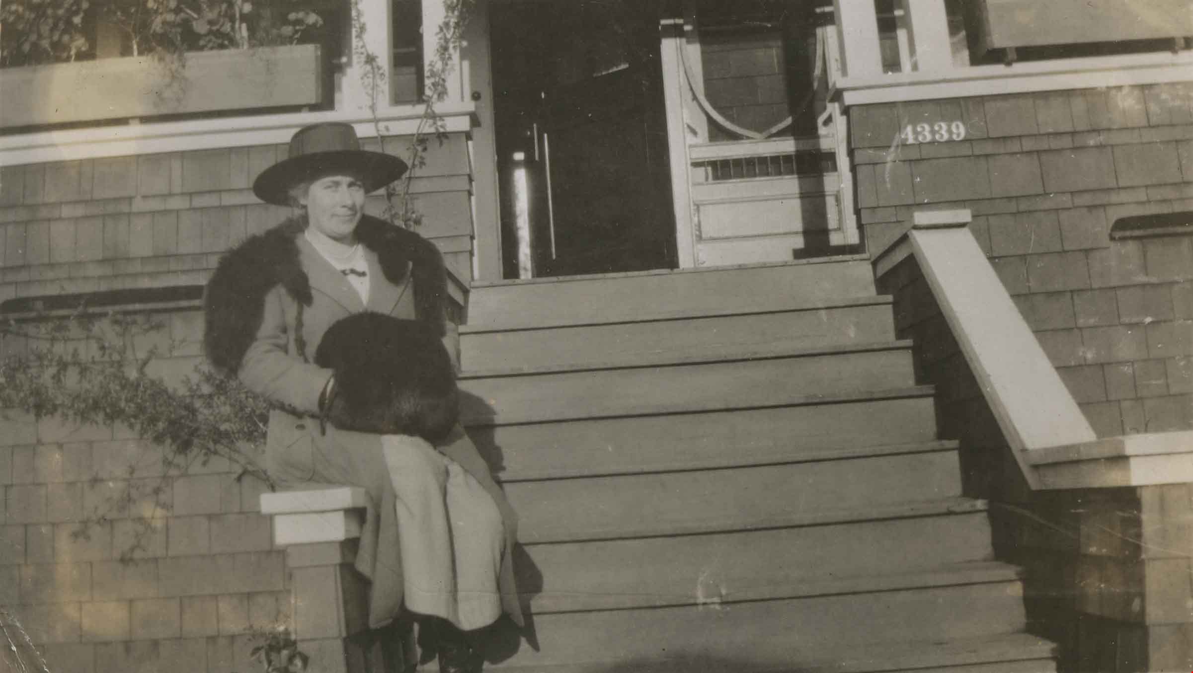
Mrs. W.H. Hoyt
https://search.heritageburnaby.ca/link/archivedescription35065
- Repository
- City of Burnaby Archives
- Date
- 1917
- Collection/Fonds
- Burnaby Historical Society fonds
- Description Level
- Item
- Physical Description
- 1 photograph : b&w ; 6.5 x 10.7 cm
- Scope and Content
- Photograph of Mrs. W.H. Hoyt, seated outside 4339 Kinnee Avenue (later renumbered and renamed 4147 Beresford Street). An annotation on the back of the photograph reads, "Mrs. W.H. Hoyt 1917 / 4339 Kinnee Ave, Burnaby B.C. / Her one and only home for 53 years. Feb 17th to Dec 24th 1970."
- Repository
- City of Burnaby Archives
- Date
- 1917
- Collection/Fonds
- Burnaby Historical Society fonds
- Subseries
- Pitman family subseries
- Physical Description
- 1 photograph : b&w ; 6.5 x 10.7 cm
- Description Level
- Item
- Record No.
- 186-009
- Access Restriction
- No restrictions
- Reproduction Restriction
- No known restrictions
- Accession Number
- BHS1986-35
- Scope and Content
- Photograph of Mrs. W.H. Hoyt, seated outside 4339 Kinnee Avenue (later renumbered and renamed 4147 Beresford Street). An annotation on the back of the photograph reads, "Mrs. W.H. Hoyt 1917 / 4339 Kinnee Ave, Burnaby B.C. / Her one and only home for 53 years. Feb 17th to Dec 24th 1970."
- Media Type
- Photograph
- Notes
- Title based on contents of photograph
- Geographic Access
- Beresford Street
- Street Address
- 4147 Beresford Street
- Historic Neighbourhood
- Central Park (Historic Neighbourhood)
- Planning Study Area
- Maywood Area
Images