Narrow Results By
Subject
- Agricultural Tools and Equipment - Plows 3
- Agriculture - Farms 9
- Agriculture - Fruit and Berries 2
- Animals - Cows 2
- Animals - Deer 1
- Animals - Dogs 10
- Animals - Horses 2
- Armament - Firearms 1
- Buildings - Agricultural - Barns 1
- Buildings - Agricultural - Stables 1
- Buildings - Commercial - General Stores 1
- Buildings - Heritage 10
Person / Organization
- Allen, James Charles 1
- Bingham, Alfred "Alf" 3
- Bird, Elizabeth "Bess" Cross Hart 2
- Bond, Evelyn 1
- Bradbury, Dr. Bettina 3
- British Columbia Electric Railway 2
- British Columbia Electric Railway Company 1
- British Columbia Hydro and Power Authority 1
- Brown, Alex 1
- Brown, Percy Boyer 1
- Buker, Phoebe 1
- Burnaby Arts Council 4
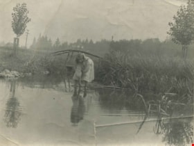
Kitty Hill wading in Deer Lake
https://search.heritageburnaby.ca/link/archivedescription39424
- Repository
- City of Burnaby Archives
- Date
- 1910
- Collection/Fonds
- Peers Family and Hill Family fonds
- Description Level
- Item
- Physical Description
- 1 photograph : b&w ; 7.2 x 10 cm
- Scope and Content
- Photograph of Kitty Hill wading in a small shallow creek. She has her feet submerged, and is dipping her hand in the water while looking up at the photographer. Just behind her is a small log bridge built over the creek, behind which can be seen a street lined with power poles, and a house in the …
- Repository
- City of Burnaby Archives
- Date
- 1910
- Collection/Fonds
- Peers Family and Hill Family fonds
- Physical Description
- 1 photograph : b&w ; 7.2 x 10 cm
- Description Level
- Item
- Record No.
- 477-743
- Access Restriction
- No restrictions
- Reproduction Restriction
- No known restrictions
- Accession Number
- 2007-12
- Scope and Content
- Photograph of Kitty Hill wading in a small shallow creek. She has her feet submerged, and is dipping her hand in the water while looking up at the photographer. Just behind her is a small log bridge built over the creek, behind which can be seen a street lined with power poles, and a house in the far distance, identified as "Broadview". An annotation on the back of the photo reads, "Kitty Hill 1910."
- Media Type
- Photograph
- Notes
- Title based on caption accompanying photograph
- Geographic Access
- Buckingham Avenue
- Deer Lake
- Street Address
- 5730 Buckingham Avenue
- Historic Neighbourhood
- Burnaby Lake (Historic Neighbourhood)
- Planning Study Area
- Morley-Buckingham Area
Images

![Kitty Hill with a parasol, [1910] thumbnail](/media/hpo/_Data/_Archives_Images/_Unrestricted/477/477-080.jpg?width=280)
Kitty Hill with a parasol
https://search.heritageburnaby.ca/link/archivedescription38761
- Repository
- City of Burnaby Archives
- Date
- [1910]
- Collection/Fonds
- Peers Family and Hill Family fonds
- Description Level
- Item
- Physical Description
- 1 photograph : sepia ; 4.5 x 5.5 cm on page 11.5 x 14 cm (pasted in album)
- Scope and Content
- Photograph of Kitty Hill sitting in a field holding a parasol. The photograph was likely taken on the Hill family property known as Broadview on Buckingham Avenue.
- Repository
- City of Burnaby Archives
- Date
- [1910]
- Collection/Fonds
- Peers Family and Hill Family fonds
- Physical Description
- 1 photograph : sepia ; 4.5 x 5.5 cm on page 11.5 x 14 cm (pasted in album)
- Description Level
- Item
- Record No.
- 477-080
- Access Restriction
- No restrictions
- Reproduction Restriction
- No known restrictions
- Accession Number
- 2007-12
- Scope and Content
- Photograph of Kitty Hill sitting in a field holding a parasol. The photograph was likely taken on the Hill family property known as Broadview on Buckingham Avenue.
- Media Type
- Photograph
- Notes
- Title based on contents of photograph
- Geographic Access
- Buckingham Avenue
- Street Address
- 5730 Buckingham Avenue
- Historic Neighbourhood
- Burnaby Lake (Historic Neighbourhood)
- Planning Study Area
- Morley-Buckingham Area
Images
![Kitty Hill with a parasol, [1910] thumbnail](/media/hpo/_Data/_Archives_Images/_Unrestricted/477/477-080.jpg)
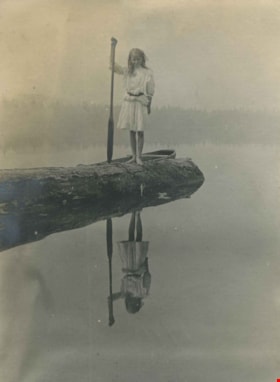
Kitty Hill with canoe paddle
https://search.heritageburnaby.ca/link/archivedescription39561
- Repository
- City of Burnaby Archives
- Date
- 1910
- Collection/Fonds
- Peers Family and Hill Family fonds
- Description Level
- Item
- Physical Description
- 1 photograph : b&w ; 7 x 9.5 cm on page 21.5 x 28 cm (pasted in album)
- Scope and Content
- Photograph of Kitty Hill standing on a log in Deer Lake holding a canoe paddle. A canoe can be seen behind her on the water.
- Repository
- City of Burnaby Archives
- Date
- 1910
- Collection/Fonds
- Peers Family and Hill Family fonds
- Physical Description
- 1 photograph : b&w ; 7 x 9.5 cm on page 21.5 x 28 cm (pasted in album)
- Description Level
- Item
- Record No.
- 477-880
- Access Restriction
- No restrictions
- Reproduction Restriction
- No known restrictions
- Accession Number
- 2007-12
- Scope and Content
- Photograph of Kitty Hill standing on a log in Deer Lake holding a canoe paddle. A canoe can be seen behind her on the water.
- Media Type
- Photograph
- Notes
- Title based on contents of photograph
- Geographic Access
- Deer Lake
- Historic Neighbourhood
- Burnaby Lake (Historic Neighbourhood)
Images

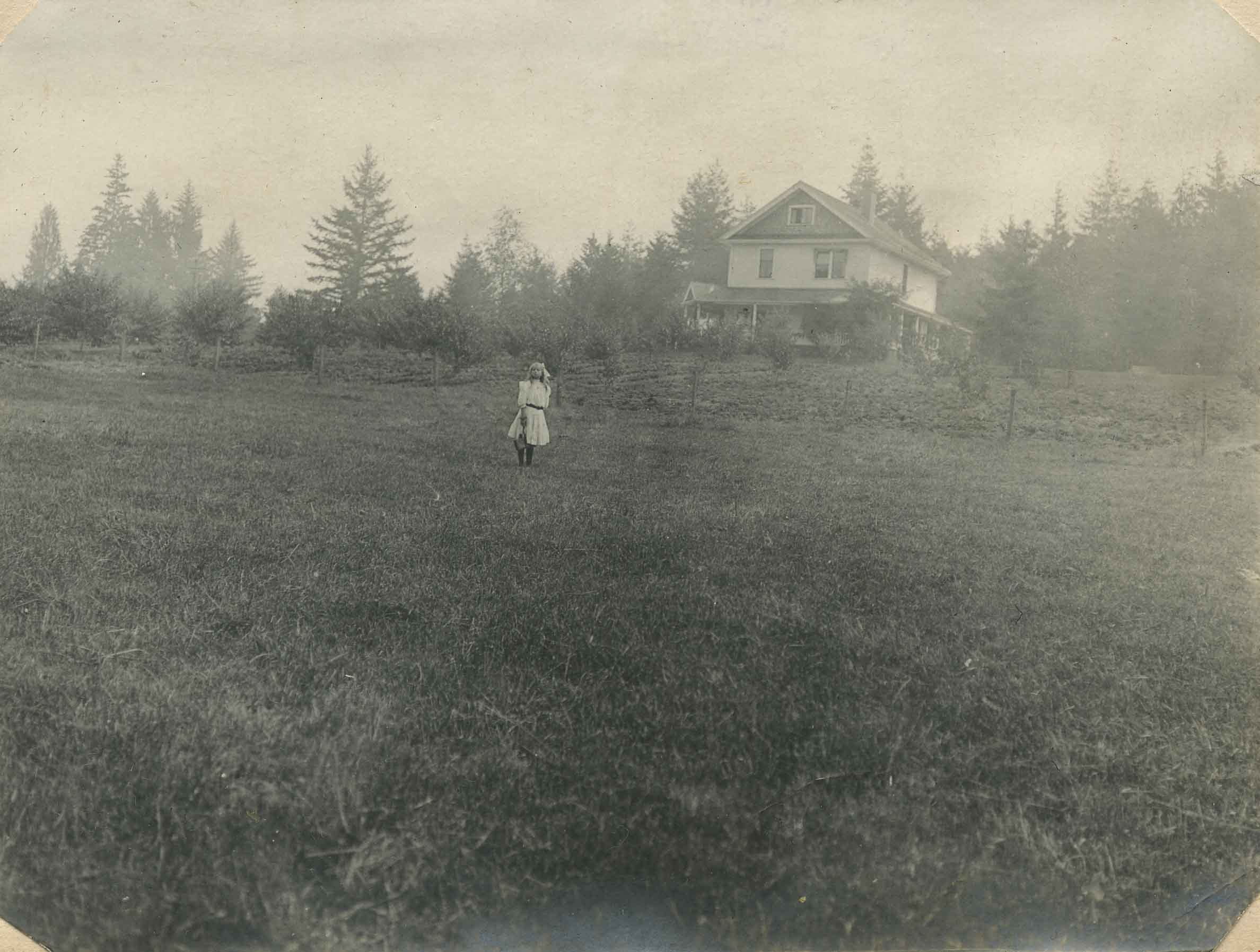
Kitty in front of Broadview
https://search.heritageburnaby.ca/link/archivedescription39556
- Repository
- City of Burnaby Archives
- Date
- 1910
- Collection/Fonds
- Peers Family and Hill Family fonds
- Description Level
- Item
- Physical Description
- 1 photograph : b&w ; 7.6 x 10.2 cm on page 21.5 x 28 cm (pasted in album)
- Scope and Content
- Photograph of Kitty Hill standing in the field in front of her family home, known as Broadview on Buckingham Avenue. This was the second Hill family home in the Burnaby Lake area and it was built around 1907. The first Hill home, Brookfield was on Deer Lake Avenue.
- Repository
- City of Burnaby Archives
- Date
- 1910
- Collection/Fonds
- Peers Family and Hill Family fonds
- Physical Description
- 1 photograph : b&w ; 7.6 x 10.2 cm on page 21.5 x 28 cm (pasted in album)
- Description Level
- Item
- Record No.
- 477-875
- Access Restriction
- No restrictions
- Reproduction Restriction
- No known restrictions
- Accession Number
- 2007-12
- Scope and Content
- Photograph of Kitty Hill standing in the field in front of her family home, known as Broadview on Buckingham Avenue. This was the second Hill family home in the Burnaby Lake area and it was built around 1907. The first Hill home, Brookfield was on Deer Lake Avenue.
- Media Type
- Photograph
- Notes
- Title based on contents of photograph
- Geographic Access
- Buckingham Avenue
- Street Address
- 5730 Buckingham Avenue
- Historic Neighbourhood
- Burnaby Lake (Historic Neighbourhood)
- Planning Study Area
- Morley-Buckingham Area
Images
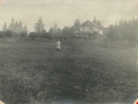
Kitty on the lawn of Broadview
https://search.heritageburnaby.ca/link/archivedescription39552
- Repository
- City of Burnaby Archives
- Date
- 1910
- Collection/Fonds
- Peers Family and Hill Family fonds
- Description Level
- Item
- Physical Description
- 1 photograph : b&w ; 8 x 10.5 cm on page 21.5 x 28 cm (pasted in album)
- Scope and Content
- Photograph of the home of Claude Hill, known as Broadview, on Buckingham Avenue. Broadview was the second Hill home in the Burnaby Lake area, the first being "Brookfield" on Deer Lake Avenue In front of the house is Claude's daughter Kitty, with a dog.
- Repository
- City of Burnaby Archives
- Date
- 1910
- Collection/Fonds
- Peers Family and Hill Family fonds
- Physical Description
- 1 photograph : b&w ; 8 x 10.5 cm on page 21.5 x 28 cm (pasted in album)
- Description Level
- Item
- Record No.
- 477-871
- Access Restriction
- No restrictions
- Reproduction Restriction
- No known restrictions
- Accession Number
- 2007-12
- Scope and Content
- Photograph of the home of Claude Hill, known as Broadview, on Buckingham Avenue. Broadview was the second Hill home in the Burnaby Lake area, the first being "Brookfield" on Deer Lake Avenue In front of the house is Claude's daughter Kitty, with a dog.
- Media Type
- Photograph
- Notes
- Title based on contents of photograph
- Geographic Access
- Buckingham Avenue
- Street Address
- 5730 Buckingham Avenue
- Historic Neighbourhood
- Burnaby Lake (Historic Neighbourhood)
- Planning Study Area
- Morley-Buckingham Area
Images

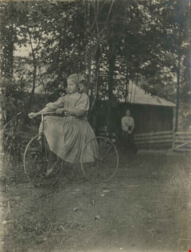
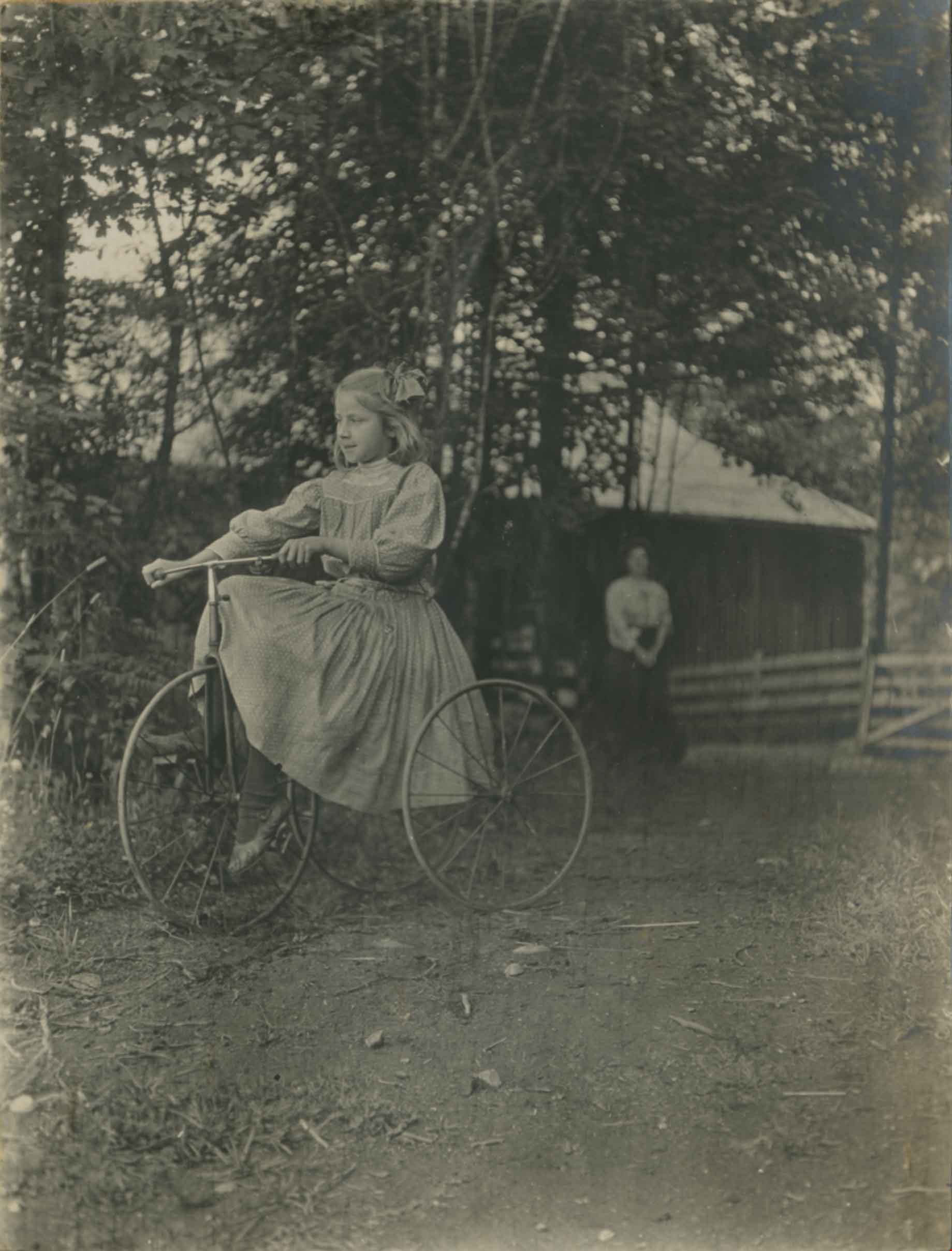
Kitty Riding a Bike
https://search.heritageburnaby.ca/link/archivedescription39438
- Repository
- City of Burnaby Archives
- Date
- 1910
- Collection/Fonds
- Peers Family and Hill Family fonds
- Description Level
- Item
- Physical Description
- 1 photograph : b&w ; 8 x 10.5 cm on page 21.5 x 28 cm (pasted in album)
- Scope and Content
- Photograph of Kitty Hill riding a bicycle. A woman, most likely her mother Annie, can be seen in the background.
- Repository
- City of Burnaby Archives
- Date
- 1910
- Collection/Fonds
- Peers Family and Hill Family fonds
- Physical Description
- 1 photograph : b&w ; 8 x 10.5 cm on page 21.5 x 28 cm (pasted in album)
- Description Level
- Item
- Record No.
- 477-757
- Access Restriction
- No restrictions
- Reproduction Restriction
- No known restrictions
- Accession Number
- 2007-12
- Scope and Content
- Photograph of Kitty Hill riding a bicycle. A woman, most likely her mother Annie, can be seen in the background.
- Subjects
- Transportation - Bicycles
- Media Type
- Photograph
- Notes
- Title based on contents of photograph
- Historic Neighbourhood
- Burnaby Lake (Historic Neighbourhood)
- Planning Study Area
- Morley-Buckingham Area
Images
![Ladies at Fairacres, [1913] thumbnail](/media/hpo/_Data/_Archives_Images/_Unrestricted/205/241-020.jpg?width=280)
Ladies at Fairacres
https://search.heritageburnaby.ca/link/archivedescription36242
- Repository
- City of Burnaby Archives
- Date
- [1913]
- Collection/Fonds
- Burnaby Historical Society fonds
- Description Level
- Item
- Physical Description
- 1 photograph : b&w copy negative ; 5.5 x 7.5 cm
- Scope and Content
- Photograph of a group of ladies standing in front of the Fairacres Mansion. Grace Ceperley is in the front, with one hand on her hip and the other hand holding a kerchief.
- Repository
- City of Burnaby Archives
- Date
- [1913]
- Collection/Fonds
- Burnaby Historical Society fonds
- Subseries
- Burnaby Art Gallery subseries
- Physical Description
- 1 photograph : b&w copy negative ; 5.5 x 7.5 cm
- Description Level
- Item
- Record No.
- 241-020
- Access Restriction
- No restrictions
- Reproduction Restriction
- No known restrictions
- Accession Number
- BHS1990-05
- Scope and Content
- Photograph of a group of ladies standing in front of the Fairacres Mansion. Grace Ceperley is in the front, with one hand on her hip and the other hand holding a kerchief.
- Names
- Ceperley, Grace
- Media Type
- Photograph
- Notes
- Title based on contents of photograph 1 b&w copy print accompanying
- Geographic Access
- Deer Lake Avenue
- Street Address
- 6344 Deer Lake Avenue
- Historic Neighbourhood
- Burnaby Lake (Historic Neighbourhood)
- Planning Study Area
- Douglas-Gilpin Area
Images
![Ladies at Fairacres, [1913] thumbnail](/media/hpo/_Data/_Archives_Images/_Unrestricted/205/241-020.jpg)
![Ladies at Fairacres, [1913] (date of original), copied 1978 thumbnail](/media/hpo/_Data/_BVM_Images/1977/197900340001.jpg?width=280)
Ladies at Fairacres
https://search.heritageburnaby.ca/link/museumdescription437
- Repository
- Burnaby Village Museum
- Date
- [1913] (date of original), copied 1978
- Collection/Fonds
- Burnaby Village Museum Photograph collection
- Description Level
- Item
- Physical Description
- 2 photographs : b&w ; 20.3 x 25.2 cm prints
- Scope and Content
- Photograph of a group of ladies standing in front of the Fairacres Mansion. Grace Ceperley is in the front, with one hand on her hip and the other hand holding a kerchief.
- Repository
- Burnaby Village Museum
- Collection/Fonds
- Burnaby Village Museum Photograph collection
- Description Level
- Item
- Physical Description
- 2 photographs : b&w ; 20.3 x 25.2 cm prints
- Scope and Content
- Photograph of a group of ladies standing in front of the Fairacres Mansion. Grace Ceperley is in the front, with one hand on her hip and the other hand holding a kerchief.
- Names
- Ceperley, Grace
- Geographic Access
- Deer Lake Avenue
- Street Address
- 6344 Deer Lake Avenue
- Accession Code
- HV979.34.1
- Access Restriction
- No restrictions
- Reproduction Restriction
- No known restrictions
- Date
- [1913] (date of original), copied 1978
- Media Type
- Photograph
- Historic Neighbourhood
- Burnaby Lake (Historic Neighbourhood)
- Planning Study Area
- Douglas-Gilpin Area
- Scan Resolution
- 600
- Scan Date
- 2023-09-12
- Notes
- Title based on contents of photograph
Images
![Ladies at Fairacres, [1913] (date of original), copied 1978 thumbnail](/media/hpo/_Data/_BVM_Images/1977/197900340001.jpg)
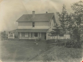
![L. Claude Hill's Broadview, [1910] thumbnail](/media/hpo/_Data/_Archives_Images/_Unrestricted/477/477-057.jpg?width=280)
L. Claude Hill's Broadview
https://search.heritageburnaby.ca/link/archivedescription38738
- Repository
- City of Burnaby Archives
- Date
- [1910]
- Collection/Fonds
- Peers Family and Hill Family fonds
- Description Level
- Item
- Physical Description
- 1 photograph : sepia ; 7 x 11.5 cm on page 11.5 x 14 cm (pasted in album)
- Scope and Content
- Photograph of the house called "Broadview" which was built by Claude Hill in the Burnaby Lake district ca. 1907.
- Repository
- City of Burnaby Archives
- Date
- [1910]
- Collection/Fonds
- Peers Family and Hill Family fonds
- Physical Description
- 1 photograph : sepia ; 7 x 11.5 cm on page 11.5 x 14 cm (pasted in album)
- Description Level
- Item
- Record No.
- 477-057
- Access Restriction
- No restrictions
- Reproduction Restriction
- No known restrictions
- Accession Number
- 2007-12
- Scope and Content
- Photograph of the house called "Broadview" which was built by Claude Hill in the Burnaby Lake district ca. 1907.
- Subjects
- Buildings - Residential - Houses
- Media Type
- Photograph
- Notes
- Title based on contents of photograph
- Geographic Access
- Buckingham Avenue
- Street Address
- 5730 Buckingham Avenue
- Historic Neighbourhood
- Burnaby Lake (Historic Neighbourhood)
- Planning Study Area
- Morley-Buckingham Area
Images
![L. Claude Hill's Broadview, [1910] thumbnail](/media/hpo/_Data/_Archives_Images/_Unrestricted/477/477-057.jpg)

Looking east along Dominion street to corner of Douglas Road and Dominion Street
https://search.heritageburnaby.ca/link/archivedescription91876
- Repository
- City of Burnaby Archives
- Date
- 2016
- Collection/Fonds
- Small family fonds
- Description Level
- Item
- Physical Description
- 1 photograph : col. ; 10 cm x 15 cm
- Scope and Content
- Photograph of Dominion Street, looking east. The houses are largely obscured by tall hedges and bushes. The photograph was taken from the north side of the street, opposite 5496 Dominion Street.
- Repository
- City of Burnaby Archives
- Date
- 2016
- Collection/Fonds
- Small family fonds
- Physical Description
- 1 photograph : col. ; 10 cm x 15 cm
- Description Level
- Item
- Record No.
- 620-057
- Access Restriction
- No restrictions
- Reproduction Restriction
- No reproduction permitted
- Accession Number
- 2017-01
- Scope and Content
- Photograph of Dominion Street, looking east. The houses are largely obscured by tall hedges and bushes. The photograph was taken from the north side of the street, opposite 5496 Dominion Street.
- Media Type
- Photograph
- Notes
- Transcribed title
- Title transcribed from donor's notes
- Note in blue ink on verso of photograph reads: "P.19"
- Note in blue ink on verso of photograph reads: "2016 / Looking East along Dominion St to corner of Douglas Rd. and Dominion St."
- Photograph 620-056 taken from the same vantage point
- Geographic Access
- Dominion Street
- Street Address
- 5538 Dominion Street
- Historic Neighbourhood
- Burnaby Lake (Historic Neighbourhood)
- Planning Study Area
- Ardingley-Sprott Area
Images


Looking east from 3131 Douglas Road
https://search.heritageburnaby.ca/link/archivedescription91826
- Repository
- City of Burnaby Archives
- Date
- January 2016
- Collection/Fonds
- Small family fonds
- Description Level
- Item
- Physical Description
- 1 photograph : col. copy print ; 15 cm x 10 cm
- Scope and Content
- Photograph of the Roberts' front yard . A large oak tree stands in the centre of the photograph with a row of short shrubs on each side. The house located at 3090 Douglas Road is visible in the distance. The photograph is taken from 3131 Douglas Road, looking east.
- Repository
- City of Burnaby Archives
- Date
- January 2016
- Collection/Fonds
- Small family fonds
- Physical Description
- 1 photograph : col. copy print ; 15 cm x 10 cm
- Description Level
- Item
- Record No.
- 620-007
- Access Restriction
- No restrictions
- Reproduction Restriction
- No reproduction permitted
- Accession Number
- 2017-01
- Scope and Content
- Photograph of the Roberts' front yard . A large oak tree stands in the centre of the photograph with a row of short shrubs on each side. The house located at 3090 Douglas Road is visible in the distance. The photograph is taken from 3131 Douglas Road, looking east.
- Media Type
- Photograph
- Notes
- Transcribed title
- Title transcribed from donor's notes
- 5118 Douglas Road renumbered to 3131 Douglas Road in 1958 and to 5538 Dominion Street in 1970 or 1971
- Note in blue ink on verso of photograph reads: "Jan. 2016 / Looking East from Roberts' front yard"
- Note in blue ink on verso of photograph reads: "P8"
- Photograph 620-003 depicts the same house on 3090 Douglas Road.
- Street Address
- 3131 Douglas Road
- 5118 Douglas Road
- 5538 Dominion Street
- 3090 Douglas Road
- Historic Neighbourhood
- Burnaby Lake (Historic Neighbourhood)
- Planning Study Area
- Ardingley-Sprott Area
Images


Looking east from north side of 5118 Douglas Road - The Roberts House
https://search.heritageburnaby.ca/link/archivedescription91821
- Repository
- City of Burnaby Archives
- Date
- 2016
- Collection/Fonds
- Small family fonds
- Description Level
- Item
- Physical Description
- 1 photograph : col. ; 10 cm x 15 cm
- Scope and Content
- Photograph of a two-storey house located at 3090 Douglas Road. The house was constructed in 1922 and is painted white with brown trim. The photograph was taken from the Roberts' property at 5538 Dominion Street.
- Repository
- City of Burnaby Archives
- Date
- 2016
- Collection/Fonds
- Small family fonds
- Physical Description
- 1 photograph : col. ; 10 cm x 15 cm
- Description Level
- Item
- Record No.
- 620-002
- Access Restriction
- No restrictions
- Reproduction Restriction
- No reproduction permitted
- Accession Number
- 2017-01
- Scope and Content
- Photograph of a two-storey house located at 3090 Douglas Road. The house was constructed in 1922 and is painted white with brown trim. The photograph was taken from the Roberts' property at 5538 Dominion Street.
- Subjects
- Buildings - Residential - Houses
- Media Type
- Photograph
- Notes
- Transcribed title
- Title transcribed from donor's notes
- The same house is visible in the background of photograph 620-001
- Note in blue ink on verso of photograph reads: "Jan. 2016 / 3090 Douglas Rd. (N.E. Corner Douglas Road and Dominion St.)
- Note in blue ink on verson of photograph reads: "P3"
- 5538 Dominion Street was previously numbered previously 5118 Douglas Road and 3131 Douglas Road
- Street Address
- 3090 Douglas Road
- Historic Neighbourhood
- Burnaby Lake (Historic Neighbourhood)
- Planning Study Area
- Ardingley-Sprott Area
Images


Looking northwest along Dominion Street from near Douglas Road
https://search.heritageburnaby.ca/link/archivedescription91846
- Repository
- City of Burnaby Archives
- Date
- April 2015
- Collection/Fonds
- Small family fonds
- Description Level
- Item
- Physical Description
- 1 photograph : col. copy print ; 10 cm x 15 cm
- Scope and Content
- Photograph of Dominion Street, looking northwest from near Douglas Road. The house at 3093 Douglas Road is just visible between the trees. In 2009 Dominion Street was repaved and sidewalks were installed following a local improvement request to the City.
- Repository
- City of Burnaby Archives
- Date
- April 2015
- Collection/Fonds
- Small family fonds
- Physical Description
- 1 photograph : col. copy print ; 10 cm x 15 cm
- Description Level
- Item
- Record No.
- 620-027
- Access Restriction
- No restrictions
- Reproduction Restriction
- No reproduction permitted
- Accession Number
- 2017-01
- Scope and Content
- Photograph of Dominion Street, looking northwest from near Douglas Road. The house at 3093 Douglas Road is just visible between the trees. In 2009 Dominion Street was repaved and sidewalks were installed following a local improvement request to the City.
- Subjects
- Buildings - Residential - Houses
- Media Type
- Photograph
- Notes
- Transcribed title
- Note in blue ink on verso of photograph reads: "P.27"
- Note in blue ink on verso of photograph reads: "April 2015 / Looking Northwest along Dominion St. from near Douglas Rd."
- Street Address
- 3093 Douglas Road
- Historic Neighbourhood
- Burnaby Lake (Historic Neighbourhood)
- Planning Study Area
- Ardingley-Sprott Area
Images


Looking northwest from Douglas Road
https://search.heritageburnaby.ca/link/archivedescription91835
- Repository
- City of Burnaby Archives
- Date
- October 2015
- Collection/Fonds
- Small family fonds
- Description Level
- Item
- Physical Description
- 1 photograph : col. copy print ; 10 cm x 15 cm
- Scope and Content
- Photograph of a two-storey house located at 3131 Douglas Road. The house is white with brown trim and a brown shingle roof. The large oak tree in the front yard of the property is full of vibrant autum-coloured leaves. The photograph was taken from across Douglas Road, looking northwest.
- Repository
- City of Burnaby Archives
- Date
- October 2015
- Collection/Fonds
- Small family fonds
- Physical Description
- 1 photograph : col. copy print ; 10 cm x 15 cm
- Description Level
- Item
- Record No.
- 620-016
- Access Restriction
- No restrictions
- Reproduction Restriction
- No reproduction permitted
- Accession Number
- 2017-01
- Scope and Content
- Photograph of a two-storey house located at 3131 Douglas Road. The house is white with brown trim and a brown shingle roof. The large oak tree in the front yard of the property is full of vibrant autum-coloured leaves. The photograph was taken from across Douglas Road, looking northwest.
- Media Type
- Photograph
- Notes
- Transcribed title
- Title transcribed from donor's notes
- Note in blue ink on verso of photograph reads: "Oct. 2016 / 3131 Douglas Rd. - with Oak Tree - Fall Colours"
- Note in blue ink on verso of photograph reads: "P.16"
- 5118 Douglas Road renumbered to 3131 Douglas Road in 1958 and to 5538 Dominion Street in 1970 or 1971
- The oak tree (centre) is the same tree as in photographs 620-007, 620-014, and 620-015
- Street Address
- 3131 Douglas Road
- 5118 Douglas Road
- 5538 Dominion Street
- Historic Neighbourhood
- Burnaby Lake (Historic Neighbourhood)
- Planning Study Area
- Ardingley-Sprott Area
Images


Looking southwest from corner of Douglas Road and Dominion Street
https://search.heritageburnaby.ca/link/archivedescription91878
- Repository
- City of Burnaby Archives
- Date
- April 2015
- Collection/Fonds
- Small family fonds
- Description Level
- Item
- Physical Description
- 1 photograph : col. copy print ; 10 cm x 15 cm
- Scope and Content
- Photograph of the houses and trees situated on the southwest corner of Douglas Road and Dominion Street. The large oak, hemlock, and fir were planted as part of the original landscaping of the Roberts' property in the 1920s. The photograph was taken from the Douglas Road and Dominion Street inter…
- Repository
- City of Burnaby Archives
- Date
- April 2015
- Collection/Fonds
- Small family fonds
- Physical Description
- 1 photograph : col. copy print ; 10 cm x 15 cm
- Description Level
- Item
- Record No.
- 620-059
- Access Restriction
- No restrictions
- Reproduction Restriction
- No reproduction permitted
- Accession Number
- 2017-01
- Scope and Content
- Photograph of the houses and trees situated on the southwest corner of Douglas Road and Dominion Street. The large oak, hemlock, and fir were planted as part of the original landscaping of the Roberts' property in the 1920s. The photograph was taken from the Douglas Road and Dominion Street intersection.
- Media Type
- Photograph
- Notes
- Transcribed title
- Title transcribed from donor's notes
- Note in blue ink on verso of photograph reads: "P.21"
- Note in blue ink on verso of photograph reads: "Looking southwest from corner of Douglas Rd. and Dominion St. / Oak Tree Hemlock Tree Fir Tree / planted in late 1920's"
- Note in black ink on verso of photograph reads: "April 2015"
- The oak tree is the same tree as in photographs 620-007, 620-014, 620-015, and 620-016
- Geographic Access
- Dominion Street
- Douglas Road
- Historic Neighbourhood
- Burnaby Lake (Historic Neighbourhood)
- Planning Study Area
- Ardingley-Sprott Area
Images


Looking west along Dominion Street from 5496 Dominion Street
https://search.heritageburnaby.ca/link/archivedescription91873
- Repository
- City of Burnaby Archives
- Date
- July 2016
- Collection/Fonds
- Small family fonds
- Description Level
- Item
- Physical Description
- 1 photograph : col. copy print ; 10 cm x 15 cm
- Scope and Content
- Photograph of the houses along Dominion Street, looking west from 5496 Dominion Street. The two houses in the foreground, 5480 and 5488 Dominion Street, were constructed in 1994 on the lot previously numbered 5486 Dominion Street.
- Repository
- City of Burnaby Archives
- Date
- July 2016
- Collection/Fonds
- Small family fonds
- Physical Description
- 1 photograph : col. copy print ; 10 cm x 15 cm
- Description Level
- Item
- Record No.
- 620-054
- Access Restriction
- No restrictions
- Reproduction Restriction
- No reproduction permitted
- Accession Number
- 2017-01
- Scope and Content
- Photograph of the houses along Dominion Street, looking west from 5496 Dominion Street. The two houses in the foreground, 5480 and 5488 Dominion Street, were constructed in 1994 on the lot previously numbered 5486 Dominion Street.
- Subjects
- Buildings - Residential - Houses
- Media Type
- Photograph
- Notes
- Transcribed title
- Title transcribed from donor's notes
- Note in blue ink on verso of photograph reads: "P.16"
- Note in blue ink on verso of photograph reads: "Houses at 5480 and 5488 Dominion St. / built in 1994"
- Photo production stamp on verso of photograph reads: "07/03/2016"
- Street Address
- 5488 Dominion Street
- 5480 Dominion Street
- Historic Neighbourhood
- Burnaby Lake (Historic Neighbourhood)
- Planning Study Area
- Ardingley-Sprott Area
Images


Looking west along Dominion Street from across the street from 5496 Dominion Street
https://search.heritageburnaby.ca/link/archivedescription91874
- Repository
- City of Burnaby Archives
- Date
- July 2016
- Collection/Fonds
- Small family fonds
- Description Level
- Item
- Physical Description
- 1 photograph : col. copy print ; 10 cm x 15 cm
- Scope and Content
- Photograph of the houses along the south side of Dominion Street with cars parked along the curb. In 2009 sidewalks were installed and the street was repaved under a neighbourhood local improvement request to the City. The photograph was taken from the north side of the street, opposite 5496 Dom…
- Repository
- City of Burnaby Archives
- Date
- July 2016
- Collection/Fonds
- Small family fonds
- Physical Description
- 1 photograph : col. copy print ; 10 cm x 15 cm
- Description Level
- Item
- Record No.
- 620-055
- Access Restriction
- No restrictions
- Reproduction Restriction
- No reproduction permitted
- Accession Number
- 2017-01
- Scope and Content
- Photograph of the houses along the south side of Dominion Street with cars parked along the curb. In 2009 sidewalks were installed and the street was repaved under a neighbourhood local improvement request to the City. The photograph was taken from the north side of the street, opposite 5496 Dominion Street, looking west.
- Media Type
- Photograph
- Notes
- Transcribed title
- Title transcribed from donor's notes
- Note in blue ink on verso of photograph reads: "P.17"
- Note in blue ink on verso of photograph reads: "Dominion St. infilled with houses on 33' lots / Photo July 2016"
- Geographic Access
- Dominion Street
- Historic Neighbourhood
- Burnaby Lake (Historic Neighbourhood)
- Planning Study Area
- Ardingley-Sprott Area
Images


Looking west along the back lane
https://search.heritageburnaby.ca/link/archivedescription91861
- Repository
- City of Burnaby Archives
- Date
- April 2015
- Collection/Fonds
- Small family fonds
- Description Level
- Item
- Physical Description
- 1 photograph : col. ; 10 cm x 15 cm
- Scope and Content
- Photograph of the back lane between Dominion Street and Norfolk Street, looking west. Visible along the Norfolk Street side of the lane are houses with garages and longer driveways. Along the Dominion Street side the lane is abutted by trees and open carports. The houses along Norfolk Street wer…
- Repository
- City of Burnaby Archives
- Date
- April 2015
- Collection/Fonds
- Small family fonds
- Physical Description
- 1 photograph : col. ; 10 cm x 15 cm
- Description Level
- Item
- Record No.
- 620-042
- Access Restriction
- No restrictions
- Reproduction Restriction
- No reproduction permitted
- Accession Number
- 2017-01
- Scope and Content
- Photograph of the back lane between Dominion Street and Norfolk Street, looking west. Visible along the Norfolk Street side of the lane are houses with garages and longer driveways. Along the Dominion Street side the lane is abutted by trees and open carports. The houses along Norfolk Street were constructed in the 1980s and 1990s following the rezoning of the properties.
- Media Type
- Photograph
- Notes
- Transcribed title
- Title transcribed from donor's notes
- Note in blue ink on verso of photograph reads: "P.5"
- Note in blue ink on verso of photograph reads: "April 1, 2015"
- Historic Neighbourhood
- Burnaby Lake (Historic Neighbourhood)
- Planning Study Area
- Ardingley-Sprott Area
Images


Looking west from back yard of 5496 Dominion Street
https://search.heritageburnaby.ca/link/archivedescription91866
- Repository
- City of Burnaby Archives
- Date
- April 1, 2015
- Collection/Fonds
- Small family fonds
- Description Level
- Item
- Physical Description
- 1 photograph : col. copy print ; 10 cm x 15 cm
- Scope and Content
- Photograph of the backyard at 5496 Dominion Street, looking west, with the houses on Norfolk Street (left) and Dominion Street (right) visible in the background.
- Repository
- City of Burnaby Archives
- Date
- April 1, 2015
- Collection/Fonds
- Small family fonds
- Physical Description
- 1 photograph : col. copy print ; 10 cm x 15 cm
- Description Level
- Item
- Record No.
- 620-047
- Access Restriction
- No restrictions
- Reproduction Restriction
- No reproduction permitted
- Accession Number
- 2017-01
- Scope and Content
- Photograph of the backyard at 5496 Dominion Street, looking west, with the houses on Norfolk Street (left) and Dominion Street (right) visible in the background.
- Media Type
- Photograph
- Notes
- Transcribed title
- Title transcribed from donor's notes
- Note in blue ink on verso of photograph reads: "P.10"
- Note in black ink on verso of photograph reads: "April 1, 2015"
- Geographic Access
- Dominion Street
- Norfolk Street
- Street Address
- 5496 Dominion Street
- Historic Neighbourhood
- Burnaby Lake (Historic Neighbourhood)
- Planning Study Area
- Ardingley-Sprott Area
Images


Looking west from Douglas Road
https://search.heritageburnaby.ca/link/archivedescription91834
- Repository
- City of Burnaby Archives
- Date
- April 2015
- Collection/Fonds
- Small family fonds
- Description Level
- Item
- Physical Description
- 1 photograph : col. copy print ; 10 cm x 15 cm
- Scope and Content
- Photograph of the houses located on the corner of Douglas Road and Dominion Street, with a large oak tree in the front of the yard. The house on the left is 3131 Douglas Road; the house behind is 5536 Dominion Street. The photograph was taken from Douglas Road, looking west.
- Repository
- City of Burnaby Archives
- Date
- April 2015
- Collection/Fonds
- Small family fonds
- Physical Description
- 1 photograph : col. copy print ; 10 cm x 15 cm
- Description Level
- Item
- Record No.
- 620-015
- Access Restriction
- No restrictions
- Reproduction Restriction
- No reproduction permitted
- Accession Number
- 2017-01
- Scope and Content
- Photograph of the houses located on the corner of Douglas Road and Dominion Street, with a large oak tree in the front of the yard. The house on the left is 3131 Douglas Road; the house behind is 5536 Dominion Street. The photograph was taken from Douglas Road, looking west.
- Media Type
- Photograph
- Notes
- Transcribed title
- Title transcribed from donor's notes
- Note in blue ink on verso of photograph reads: "April 2015 / 3131 Douglas Rd. / with Oak Tree"
- Note in blue ink on verso of photograph reads: "P.15"
- 5118 Douglas Road renumbered to 3131 Douglas Road in 1958 and to 5538 Dominion Street in 1970 or 1971
- The oak tree (centre) is the same tree as in photographs 620-007 and 620-014
- Street Address
- 3131 Douglas Road
- 5118 Douglas Road
- 5538 Dominion Street
- Historic Neighbourhood
- Burnaby Lake (Historic Neighbourhood)
- Planning Study Area
- Ardingley-Sprott Area
Images
