More like 'First Nations chief and Police Officer'
Narrow Results By
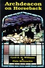
Archdeacon on horseback : Richard Small, 1849-1909, missionary at Lytton, Chaplain at St. Bartholomew's Hospital, Lytton and Archdeacon of Yale
https://search.heritageburnaby.ca/link/museumlibrary715
- Repository
- Burnaby Village Museum
- Collection
- Reference Collection
- Material Type
- Book
- ISBN
- 0929069056
- 092906903X
- Call Number
- 283.711 WIL
- Place of Publication
- Merritt, B.C.
- Publisher
- Sonotek Publishing
- Publication Date
- c1991
- Physical Description
- 112 p. : ill. ; 23 cm.
- Inscription
- "All good wishes to Colin / and many thanks for contributing / an enjoyable segment to the / 1992 B.C. Historical Federation / Convention. / Pixie McGeachie / May 20/92", written in ink on cover page.
- "Dear Colin - / Thank you again for giving up / your Saturday morning in order / to give B.C.H.F. delegates an / interesting & informative bus tour / commentary. Your contribution to / the convention is much appreciated. / Sincerely, / Pixie", hand-written note in ink inserted into book.
- Library Subject (LOC)
- Missions
- Indigenous peoples--British Columbia
- Notes
- Includes bibliographical references (p. 103-106) and index.
BC Studies : Native peoples and colonialism, special double issue, numbers 115/116, Autumn/Winter 1997/98
https://search.heritageburnaby.ca/link/museumlibrary7444
- Repository
- Burnaby Village Museum
- Collection
- Reference Collection
- Material Type
- Book
- Call Number
- 917.11 BCS
- Contributor
- Harris, Cole, 1936-
- Barman, Jean, 1939-
- Place of Publication
- Vancouver, BC, Canada
- Publisher
- University of British Columbia
- Publication Date
- 1998
- Series
- BC Studies
- Physical Description
- 307 p. : ill., maps, ports. ; 23 cm.
- Library Subject (LOC)
- British Columbia--History
- Notes
- Contributor: "Co-editors: Cole Harris and Jean Barman" -- front end paper
- ISSN : 0005-2949
Legends of Vancouver
https://search.heritageburnaby.ca/link/museumlibrary5197
- Repository
- Burnaby Village Museum
- Collection
- Special Collection
- Material Type
- Book
- Accession Code
- BV002.90.3
- Call Number
- 398.2 JOH
- Edition
- 8th ed.
- Place of Publication
- Vancouver
- Publisher
- Saturday Sunset Presses
- Publication Date
- 1913
- Physical Description
- xvii, 138 p. : ill. ; 23 cm.
- Library Subject (LOC)
- Legends--British Columbia--Vancouver Island
- Spirituality--Indigenous--North America
- Geographic Access
- Vancouver
- Notes
- Leather jacket with painted profile, title, and author, includes leather bookmark and souvenir dagger.
- Inside the jacket is a newspaper clipping of a soldier from Vancouver wounded at Vimy Ridge.
- Author's given name and dates : Johnson, E. Pauline (Emily Pauline), (Tekahionwake),1861-1913
Interview with Cice Brown, May 13, 2005 - Track 5
https://search.heritageburnaby.ca/link/museumdescription4480
- Repository
- Burnaby Village Museum
- Date
- 1930-1949 (interview content), interviewed May 10, 2005
- Collection/Fonds
- Burnaby Village Museum fonds
- Description Level
- Item
- Physical Description
- 1 sound recording (mp3) (0:07:55 min)
- Scope and Content
- Track 5: This portion of the recording continues with the topic of recreation. The next questions pertain to restrictions on children at the time, cultural diversity, living arrangements, and toys. Cice is asked to describe her best and worst memories. She mentions that there were few restrictions …
- Repository
- Burnaby Village Museum
- Collection/Fonds
- Burnaby Village Museum fonds
- Series
- Museum Oral Histories series
- Subseries
- Growing Up in Burnaby subseries
- Description Level
- Item
- Physical Description
- 1 sound recording (mp3) (0:07:55 min)
- Material Details
- Interviewer: Tom Gooden Interviewee: Cice Brown Date of Interview: May 13, 2005 Total Number of Tracks: 7 Total length of all Tracks: 0:40:19
- Scope and Content
- Track 5: This portion of the recording continues with the topic of recreation. The next questions pertain to restrictions on children at the time, cultural diversity, living arrangements, and toys. Cice is asked to describe her best and worst memories. She mentions that there were few restrictions on children, and discusses the nature of community at the time. She comments on the cultural and religious backgrounds of the people she knew. Cice describes her family’s home and living arrangements, and how they reflected her family’s situation. She recalls a favourite toy.
- History
- Recording of an interview with Cice Brown, interviewed by Tom Gooden on May 13 2005. This recording was completed for an exhibit, Growing Up in Burnaby, for the Burnaby Village Museum. Major themes discussed are growing up in Burnaby in the 1930s and 40s.
- Creator
- Burnaby Village Museum
- Names
- Brown, Cice Chandler
- Accession Code
- BV017.45.3
- Access Restriction
- No restrictions
- Reproduction Restriction
- May be restricted by third party rights
- Date
- 1930-1949 (interview content), interviewed May 10, 2005
- Media Type
- Sound Recording
Audio Tracks
Interview with Cice Brown, May 13, 2005 - Track 5, 1930-1949 (interview content), interviewed May 10, 2005
Interview with Cice Brown, May 13, 2005 - Track 5, 1930-1949 (interview content), interviewed May 10, 2005
https://search.heritageburnaby.ca/media/hpo/_Data/_BVM_Sound_Recordings/Oral_Histories/2017_0045_0003_005.mp3
Lee Crowchild
https://search.heritageburnaby.ca/link/archivedescription78849
- Repository
- City of Burnaby Archives
- Date
- February 11, 1996
- Collection/Fonds
- Burnaby NewsLeader photograph collection
- Description Level
- Item
- Physical Description
- 1 photograph : b&w ; 17.5 x 23 cm
- Scope and Content
- Photograph of Lee Crowchild during the Burnaby School District's "First Nations Career Day" at the Schou Education Centre.
- Repository
- City of Burnaby Archives
- Date
- February 11, 1996
- Collection/Fonds
- Burnaby NewsLeader photograph collection
- Physical Description
- 1 photograph : b&w ; 17.5 x 23 cm
- Description Level
- Item
- Record No.
- 535-0164
- Access Restriction
- No restrictions
- Reproduction Restriction
- No reproduction permitted
- Accession Number
- 2012-11
- Scope and Content
- Photograph of Lee Crowchild during the Burnaby School District's "First Nations Career Day" at the Schou Education Centre.
- Media Type
- Photograph
- Photographer
- Blissett, Rebecca
- Notes
- Title based on contents of photograph
- Note in black ink on recto of photograph reads: "Bby 377 Rebecca / Bby - 10 - 65%"
- Trim marks and/or reproduction instructions on recto (scan is cropped)
Images
Metro-McNair Clinical Laboratories
https://search.heritageburnaby.ca/link/archivedescription79307
- Repository
- City of Burnaby Archives
- Date
- June 30, 1996
- Collection/Fonds
- Burnaby NewsLeader photograph collection
- Description Level
- Item
- Physical Description
- 1 photograph : b&w ; 17.5 x 19.5 cm
- Scope and Content
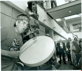
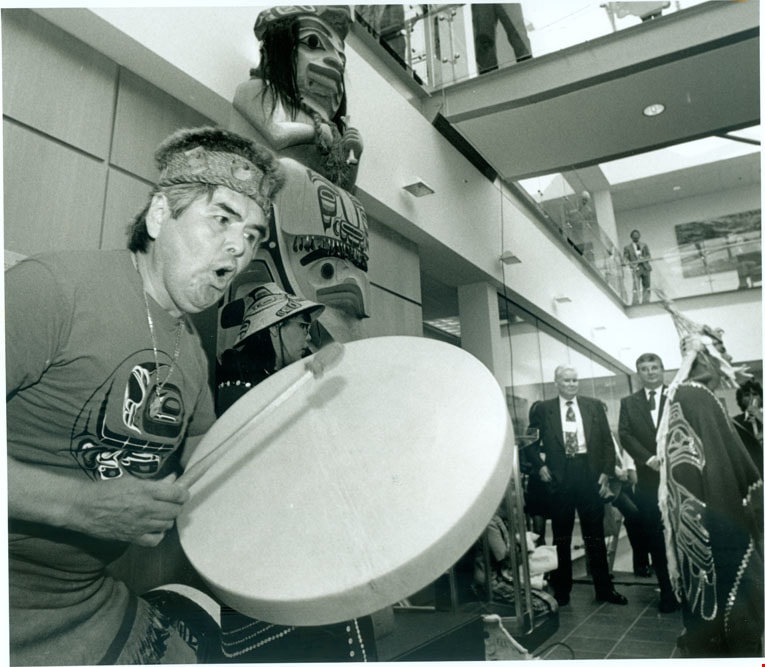
- Photograph of the Metro-McNair Clinical Laboratories opening ceremony. An unidentified man is playing a hand drum next to the "Medicine Man Pole" carved by Haida artist Reg Davidson.
- Repository
- City of Burnaby Archives
- Date
- June 30, 1996
- Collection/Fonds
- Burnaby NewsLeader photograph collection
- Physical Description
- 1 photograph : b&w ; 17.5 x 19.5 cm
- Description Level
- Item
- Record No.
- 535-0335
- Access Restriction
- No restrictions
- Reproduction Restriction
- No reproduction permitted
- Accession Number
- 2012-11
- Scope and Content
- Photograph of the Metro-McNair Clinical Laboratories opening ceremony. An unidentified man is playing a hand drum next to the "Medicine Man Pole" carved by Haida artist Reg Davidson.
- Media Type
- Photograph
- Photographer
- Ponne, Simone
- Notes
- Title based on contents of photograph
- Note in black ink on recto of photograph reads: "Bby NW P3 / 1683 D Bby Simone"
- Trim marks and/or reproduction instructions on recto (scan is cropped)
Images
![Survey and Subdivision plans in New Westminster District Group 1 and Group 2 – Vancouver, ʷməθkʷəy̓əm (Musqueam) Indian Reserve, Burnaby, Surrey
, [1910-1911] thumbnail](/media/hpo/_Data/_BVM_Cartographic_Material/1977/1977_0093_0017_001.jpg?width=280)
Survey and Subdivision plans in New Westminster District Group 1 and Group 2 – Vancouver, ʷməθkʷəy̓əm (Musqueam) Indian Reserve, Burnaby, Surrey
https://search.heritageburnaby.ca/link/museumdescription6986
- Repository
- Burnaby Village Museum
- Date
- [1910-1911]
- Collection/Fonds
- Burnaby Village Museum Map collection
- Description Level
- File
- Physical Description
- 9 plans : 4 plans : blueprint ink on paper + 4 plans : black ink on paper + 1 plan : graphite on paper mounted on 2 sides of cardboard 76 x 102 cm
- Scope and Content
- File consists of a large board of three survey plans in New Westminster District Group 1 mounted on one side and six survey and subdivision plans of District Lot 85, New Westminster District Group 1 mounted on the other side. Side A: 1. Plan : blueprint on paper ; 30.5 x 80 cm. Title reads: "Fras…
- Repository
- Burnaby Village Museum
- Collection/Fonds
- Burnaby Village Museum Map collection
- Description Level
- File
- Physical Description
- 9 plans : 4 plans : blueprint ink on paper + 4 plans : black ink on paper + 1 plan : graphite on paper mounted on 2 sides of cardboard 76 x 102 cm
- Material Details
- Scales vary (One chain equals 792 inches)
- Indexed number on tape on edge of board reads "17"
- Scope and Content
- File consists of a large board of three survey plans in New Westminster District Group 1 mounted on one side and six survey and subdivision plans of District Lot 85, New Westminster District Group 1 mounted on the other side. Side A: 1. Plan : blueprint on paper ; 30.5 x 80 cm. Title reads: "Fraser River Bridge / Plan of South Approach". Plan covers area of land north of the Fraser River and Great Northern Railway with approach for a bridge running through the "ʷməθkʷəy̓əm (Musqueam) Indian Reserve" (ʷməθkʷəy̓əm (Musqueam) First Nation) and lots marked as Dominion Government and the east half of Lot 2 identified as "C. F. Brown" "Plan 851". Plan is identified as "Plan 851 / traced / Mar. 17, 1911". (Geographic location in Vancouver) Scale: 100 feet = 1 inch, Signed by Albert J. Hill / P.L.S." 2. Plan : blueprint on paper ; 36.5 x 35 cm (no title). Includes three plans of lots on the east and west sides of North Road. Note on bottom of blueprint reads: "I.E.B. McKay Surveyor General - hereby certify / that this is a correct tracing from the field / notes of the Royal Engineers on file in the / Lands Department / E.B. McKay (signature) / Surveyor General / Victoria B.C. April 11th 1911" . Plan in top left titled "Page 11 / Vol. 1. / R.E. Notes" covers District Lots east of North Road including Lot 5, Lot 7, Lot 41, Lot 9 and Lot 107 in Coquitlam. Plan in top right corner titled "Page 17 / Vol. 1. / R.E. Notes" covers District Lots east of North Road including Lot 104, Lot 54, Lot 105, Lot 55, Lot 106, Lot 9 and Lot 107 in Coquitlam and Port Moody. Plan in lower left corner titled "Page 15 / Vol. 1 / R.E. Notes" covers District Lots west of North Road including Lot 147, Lot 148, Lot 100, Lot 15 in Burnaby. 3. Plan : blue print on paper ; 29.5 x 41.5 cm. (no formal title). Plan of the North 1/2 of Section 18. Plan covers area in the "North 1/2 of Sec.18 B.5 N RGE 1 W" and "Sec. 18 B.5 N. RGE 1 W" bordered by Section 7, Section 13, Section 17 and Section 19. Bon Accord Road runs through Sec. 18. The plan is signed by surveryor "I.H. Neville Smith... C.E.B.C.L.S. / Mar. 26th 1910" and signed by "Ludwig Pillath". (Geographic location: Surrey) Side B: 1. Plan : blueprint on paper ; 43.5 x 49.5 cm. Title reads: "Plan / of Subdivision / of a Portion / of / Lot 85 / Group One / New Westminster District. Plan covers portion of land east of Deer Lake and Pole Line Road (Sperling Avenue) and south of Hastings Road in District Lot 85 in Burnaby with section 4 and a portion of section 2 coloured in red. Plan is signed by "Albert J. Hill, B.C.L.S." Plan is initialed by: "RB" [sic] (in blue pencil crayon) Scale: 4 chains = 1 inch 2. Plaln : black black ink on linen ; 39 x 37 cm. Title reads: "L.C. Hill's Property, / Burnaby". Plan covers a triangular portion of land east of Pole Line Road (Sperling Avenue) and south of Hastings Road in District Lot 85 in Burnaby. Plan is intitaled by "RB" [sic] (in blue pencil crayon). Scale: 3 chains = 1 mile 3. Plan : graphite on paper ; 23 x 17 cm. Title reads: "Portion of Lot 85 / Gr.1". Plan covers portion of land north east of Deer Lake and west of Pole Line Road (now Sperling Avenue) in District Lot 85 in Burnaby. Plan is stamped in red ink: "Albert J. Hill, Civil Engineer". Plan is initialed by: "RB" [sic] (in blue pencil crayon). Scale: 1 chain = 1 inch 4. Plan : black ink on linen ; 16 x 19 cm. Title reads: "Lot 85". Plan covers the intersection of Pole Line Road (Sperling Avenue) and Hastings Road at the north west section of District Lot 79 and District Lot 85 in Burnaby. Plan is stamped: "A.J. Hill, Civil Engineer" with identitifed in blue pencil crayon. 5. Plan : black ink on paper ; 28.5 x 37 cm. (no formal title) Plan covers an area of land, west of Pole Line Road (Sperling Avenue) and south of Deer Lake in District Lot 85 in Burnaby. Plan is initialed by: "RB" [sic] (in blue pencil crayon) 6. Plan : black ink on paper ; 21 x 34 cm (no formal title). Plan covers an area of land, west of Pole Line Road (Sperling Avenue) and south of Deer Lake in District Lot 85 in Burnaby. Plan is initialed by: "RB" [sic] (in blue pencil crayon)
- Accession Code
- HV977.93.17
- Access Restriction
- No restrictions
- Reproduction Restriction
- No known restrictions
- Date
- [1910-1911]
- Media Type
- Cartographic Material
- Historic Neighbourhood
- Burnaby Lake (Historic Neighbourhood)
- Burquitlam (Historic Neighbourhood)
- Planning Study Area
- Morley-Buckingham Area
- Douglas-Gilpin Area
- Scan Resolution
- 600
- Scan Date
- 2023-06-26
- Notes
- Title based on contents of file
- Scale is measured in chains and feet. (One chain equals 792 inches).
- The term "Lot" also refers to a "District Lot”
- Some plans are stamped: "Albert J. Hill, Civil Engineer / and / Provincial Land Surveyor, / New Westminster, / B.C." and intialed: "RB" [sic]
Zoomable Images
![Survey and Subdivision plans in New Westminster District Group 1 and Group 2 – Vancouver, ʷməθkʷəy̓əm (Musqueam) Indian Reserve, Burnaby, Surrey
, [1910-1911] thumbnail](/media/hpo/_Data/_BVM_Cartographic_Material/1977/1977_0093_0017_003_seadragon/1977_0093_0017_003.jpg?w=280)
Survey and Subdivision plans in New Westminster District Group 1 and Group 2 – Vancouver, ʷməθkʷəy̓əm (Musqueam) Indian Reserve, Burnaby, Surrey , [1910-1911]
Zoom into Image
![Survey and Subdivision plans in New Westminster District Group 1 & Group 2 - Port Moody, Surrey
, [1898-1910] thumbnail](/media/hpo/_Data/_BVM_Cartographic_Material/1977/1977_0093_0073_001.jpg?width=280)
Survey and Subdivision plans in New Westminster District Group 1 & Group 2 - Port Moody, Surrey
https://search.heritageburnaby.ca/link/museumdescription7042
- Repository
- Burnaby Village Museum
- Date
- [1898-1910]
- Collection/Fonds
- Burnaby Village Museum Map collection
- Description Level
- File
- Physical Description
- 10 plans : graphite and ink on paper and linen; various sizes mounted on 2 sides of cardboard 76 x 102 cm
- Scope and Content
- File consists of a large board with four plans in New Westminster District mounted on one side and six plans mounted on the other side. Side A: 1. Plan : black ink and graphite on paper ; 46.5 x 37.5 cm. Title reads: "Bon Accord Hatchery / Sec 6 B5N R1W". Signed by Albert J. Hill P.L.S. August 1…
- Repository
- Burnaby Village Museum
- Collection/Fonds
- Burnaby Village Museum Map collection
- Description Level
- File
- Physical Description
- 10 plans : graphite and ink on paper and linen; various sizes mounted on 2 sides of cardboard 76 x 102 cm
- Material Details
- Scales vary (One chain equals 792 inches)
- Indexed number on tape on edge of board reads "73"
- Scope and Content
- File consists of a large board with four plans in New Westminster District mounted on one side and six plans mounted on the other side. Side A: 1. Plan : black ink and graphite on paper ; 46.5 x 37.5 cm. Title reads: "Bon Accord Hatchery / Sec 6 B5N R1W". Signed by Albert J. Hill P.L.S. August 12, 1903. Plan covers land identified as Section 6, Section 7, Located along the south shore of the Fraser River in Port Mann (Geographic location: Surrey). 2. Plan : black ink and graphite on paper ; 36 x 31 cm. Title reads: "Survey of Portions of Sec. 20 B5N R2W". Plan is stamped in red ink: "Albert J. Hill, Civil Engineer". Scale 4 chains = 1 inch. 3. Plan : black ink on linen ; 14 x 23 cm. Title reads:"Port Moody". Plan covers sections in Lot 191 (District Lot 191) bordered by Burrard Inlet to the west and Lot 235 and Lot 233 to the south. Streets identified include Water Street, Beauregard Street, Yonge Street, Clinton Street and Oxford Street. 4. Plan: graphite and ink on paper ; 43.5 x 64.5 cm. Title reads: "Sketch Plan Approved by Council [sic] / _[sic]1898". (No identifying geographic landmarks provided) Side B: 1. Plan : graphite on paper ; 53.5 x 31 cm. Title reads: "Plan of Lot 13, Gr. II, N.W. Dist". Sketch plan covers area along the Fraser River in District Lot 13, New Westminster District, Group 2. District Lot 13 is bordered by District Lot 14 (to the west) and Lot 12 (to the east). Natural geographic features within District Lot 13 are noted as "dense brush and fallen timber / sallal / rough spruce and cedar / swamp / fine alder / sallal / fine alder bottom land / fine brook". Scale: 3 chains = 1 inch (Geographic location: Surrey) 2. Plan : black ink on paper ; 50.5 x 34.5 cm. Title reads: "Indian Reserve / Opposite / New Westminster". Plan covers area on the south shore of the Fraser River in New Westminster District Group 2 in an area known as Brownsville. Lots are identified as District Lots 1, 2, 3, 4, 18, 17 and 8 and Sections A and B. Two areas of land are noted as "Indian Reserve"; one 6.3 acre parcel and one 104.25 acre parcel, both within District Lot 1. Note on plan reads: "N.B. this plan shows reserves and adjacent properties as they are on the ground". (Geographic location: Surrey) 3. Plan : black and col. ink on paper ; 19.5 x 31.5 cm. Title reads: "Bon Accord Road". Plan shows elevation. "Average section 10 feet = 1 inch". Plan is stamped in red ink: "Albert J. Hill, Civil Engineer and Provincial Land Surveyor, New Westminster, B.C." (Geographic location: Surrey) 4. Plan : black and col. ink on linen ; 16.5 x 25.5 cm. (no formal title) Plan covers area of Section 35, south of Yale Wagon Road and east of Quible Road. Plan is signed by "Albert J. Hill / B.C.L.S." (Geographic location: Surrey) 5. Plan: black and col. ink on linen ; 22.5 x 22.5 cm. (no formal title) Plan covers area between Yale Road and Townline Road in Surrey. Scale: 4 chains = 1 inch. Plan is signed by Albert J. Hill B.C.L.S. [190-] (Geographic location: Surrey) 6. Plan : graphite on paper ; 24 x 54 cm. (no formal title) Plan covers sectioned areas along Bon Accord Road. Sections are identified as " Sec. 8 / T.F. Patterson"; "Sec. 9 / Russell"; "Elliott_Burnett_Crean / Sec. 16"; "Dom. Govt. / Sec. 17". (Geographic location: Surrey, beneath the Port Mann bridge)
- Names
- ʷməθkʷəy̓əm (Musqueam)
- Accession Code
- HV977.93.73
- Access Restriction
- No restrictions
- Reproduction Restriction
- No known restrictions
- Date
- [1898-1910]
- Media Type
- Cartographic Material
- Scan Resolution
- 600
- Scan Date
- 2023-06-26
- Notes
- Title based on contents of file
- Note re plan 2B: The sight of Brownsville was also the former site of the Qayqayt First Nation and one of the main summer villages of the Kwantlen and ʷməθkʷəy̓əm (Musqueam) peoples
Zoomable Images
![Survey and Subdivision plans in New Westminster District Group 1 & Group 2 - Port Moody, Surrey
, [1898-1910] thumbnail](/media/hpo/_Data/_BVM_Cartographic_Material/1977/1977_0093_0073_003_seadragon/1977_0093_0073_003.jpg?w=280)
Survey and Subdivision plans in New Westminster District Group 1 & Group 2 - Port Moody, Surrey , [1898-1910]
Zoom into Image
![Survey and Subdivision plans in New Westminster District Group 2 - Surrey, Delta
, [1898-1910] thumbnail](/media/hpo/_Data/_BVM_Cartographic_Material/1977/1977_0093_0078_001.jpg?width=280)
Survey and Subdivision plans in New Westminster District Group 2 - Surrey, Delta
https://search.heritageburnaby.ca/link/museumdescription7047
- Repository
- Burnaby Village Museum
- Date
- [1898-1910]
- Collection/Fonds
- Burnaby Village Museum Map collection
- Description Level
- File
- Physical Description
- 10 plans : graphite and ink on paper and linen; various sizes mounted on 2 sides of cardboard 76 x 102 cm
- Scope and Content
- File consists of a large board with four plans in New Westminster District mounted on one side and six plans mounted on the other side. Side A: 1. Plan : black ink on paper with colour (no formal title). Plan covers area in New Westminster District, Group 2 situated along the south shore of the …
- Repository
- Burnaby Village Museum
- Collection/Fonds
- Burnaby Village Museum Map collection
- Description Level
- File
- Physical Description
- 10 plans : graphite and ink on paper and linen; various sizes mounted on 2 sides of cardboard 76 x 102 cm
- Material Details
- Scales vary
- Indexed number on tape on edge of board reads "78"
- Scope and Content
- File consists of a large board with four plans in New Westminster District mounted on one side and six plans mounted on the other side. Side A: 1. Plan : black ink on paper with colour (no formal title). Plan covers area in New Westminster District, Group 2 situated along the south shore of the Fraser River identified as "Indian Reserve / Turner 1868" situated in District Lot 1 between District Lot 2 identified as "Mohun's Line" and "Herring's Line" bordered by lots B and A. Includes note "see plan of subdivision of Lots 3 & 4 Gr. 2". (Geographic location: Surrey) 2. Plan : graphite on paper ; Title reads: "B5N R2W, Sec.26_Sec. 28 / Sec. 35_Sec.36". Plan covers a 60 acre parcel in Sec. 35 with Yale wagon road to the south. Scale: 6 chains = 1 inch (Geographic location: Surrey) 3. Plan : black ink on paper ; Title reads: "Survey for Proposed Highway in Indian Reserve Surrey". Plan covers area of land to the northwest of Lot 2 along the shore of the Fraser River and identfies route of proposed highway, proposed tramway as well at the Great Northern Railway and bridge. Scale: 2 chains = 1 inch 4. Plan : black ink on red lined graphing paper ; Title reads: "Sketch Plan Showing Section of Great Northern R. of W. at Point of Crossing of Proposed Ditch". Plan covers area of Lot 2 in New Westminster District, Group 2. (Surrey) Scale: 1 inch = 5 feet. (Geographic location: Surrey) Side B: 1. Plan : black ink on paper ; Title reads: "Plan of Subdivision of a Portion of Section 13, TP2, Surrey Municipality, New Westminster District, B.C.". Plan covers land bordered by Coast Meridian Road (to the east), Bose Road (to the south) and Pike Road (to the west). Surveyed for D.S. Bayners, Nov. 24, 1908. Scale: 5 chains= 1 inch 2. Plan : black ink on linen with colour ; Title reads: "Traverse of the Waterline in front of Lots 3 and 4, Group 2, New Westminster District with G.N. Railway Right of Way". Plan covers area along the southern shore of the Fraser River with a road crossing the Great Northern Railway and leading to a wharf. Scale: 100 feet = 1 inch (Geographic location: Surrey) 3. Plan : black ink on paper ; Title reads: "Survey of the South Boundary of Sec. 12, Township 2, New Westminster District". Plan covers area south of Bose Road and west of Coast Meridean Road and north of McClellen Road. Scale: 400 feet = 1 inch. Sec.12 (Geographic location: Surrey) 4. Plan : graphite on paper ; Title reads: "Plan of Subdivisioin of a part of S.E. 1/4 of Sec. 7, TP 8". Plan covers area of Section 7 in New Westminster District, Group 2, Township 8. Streets are identified running through lot including, Langley Ave., Robinson Ave, Melrose Ave., Hawthorne Ave., Broadway, Bond Ave., Mable Ave., Breene Ave. and McLelland Ave. and Clover Valley Road. Scale: 200 feet = 1 inch. Note in black ink reads: See Bd. 166 for blue print. (Geographic location: Surrey) 5. Plan : graphite on linen ; Title reads: "Sec.20, B5N R2W". Plan covers area north of Yale Road and is subdivided into parts identified as A, B, C, D, E, and unknown. (Geographic location: Surrey) 6. Plan : black ink and graphite on paper ; (no formal title) Plan covers lots surveyed along Ladner Road identified as A, B and Lots 13, 12 and 11. [Geographic location: Delta]
- Accession Code
- HV977.93.78
- Access Restriction
- No restrictions
- Reproduction Restriction
- No known restrictions
- Date
- [1898-1910]
- Media Type
- Cartographic Material
- Scan Resolution
- 600
- Scan Date
- 2023-06-26
- Notes
- Title based on contents of file
- Note re plans 1A & 3A: The sight of Brownsville was also the former site of the Qayqayt First Nation and one of the main summer villages of the Kwantlen and ʷməθkʷəy̓əm (Musqueam) peoples
- Scale is measured in chains and feet. (One chain equals 792 inches)
Zoomable Images
![Survey and Subdivision plans in New Westminster District Group 2 - Surrey, Delta
, [1898-1910] thumbnail](/media/hpo/_Data/_BVM_Cartographic_Material/1977/1977_0093_0078_003_seadragon/1977_0093_0078_003.jpg?w=280)
Survey and Subdivision plans in New Westminster District Group 2 - Surrey, Delta , [1898-1910]
Zoom into Image

Bill Copeland with Wayne Brassington and Bob Fenske
https://search.heritageburnaby.ca/link/archivedescription79136
- Repository
- City of Burnaby Archives
- Date
- April 21, 1996
- Collection/Fonds
- Burnaby NewsLeader photograph collection
- Description Level
- Item
- Physical Description
- 1 photograph : b&w ; 18 x 21 cm
- Scope and Content
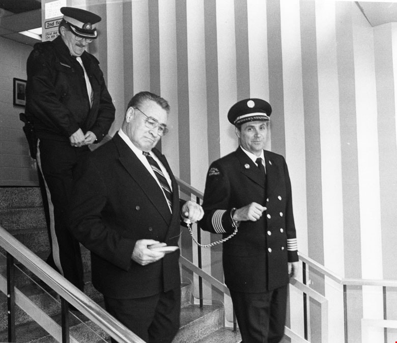
- Photograph of Burnaby mayor Bill Copeland with fire chief Wayne Brassington and Royal Canadian Mounted Police (RCMP) superintendent Bob Fenske leaving the Canadian Cancer Society's annual "Jail 'n' Bail" fundraiser. The mayor and fire chief were handcuffed together as they left the fundraiser.
- Repository
- City of Burnaby Archives
- Date
- April 21, 1996
- Collection/Fonds
- Burnaby NewsLeader photograph collection
- Physical Description
- 1 photograph : b&w ; 18 x 21 cm
- Description Level
- Item
- Record No.
- 535-0273
- Access Restriction
- No restrictions
- Reproduction Restriction
- No reproduction permitted
- Accession Number
- 2012-11
- Scope and Content
- Photograph of Burnaby mayor Bill Copeland with fire chief Wayne Brassington and Royal Canadian Mounted Police (RCMP) superintendent Bob Fenske leaving the Canadian Cancer Society's annual "Jail 'n' Bail" fundraiser. The mayor and fire chief were handcuffed together as they left the fundraiser.
- Subjects
- Officials - Mayors and Reeves
- Clothing - Uniforms
- Public Services - Policing
- Occupations - Fire Fighters
- Media Type
- Photograph
- Photographer
- Ponne, Simone
- Notes
- Title based on contents of photograph
- Note in black and blue ink on recto of photograph reads: "1024 Bby Simone / 4/21 Bby pg. 1 78%"
- Trim marks and/or reproduction instructions on recto (scan is cropped)
Images

Burnaby Mounted Police
https://search.heritageburnaby.ca/link/archivedescription36376
- Repository
- City of Burnaby Archives
- Date
- 1913
- Collection/Fonds
- Burnaby Historical Society fonds
- Description Level
- Item
- Physical Description
- 1 photograph : sepia postcard ; 8.5 x 13.5 cm
- Scope and Content
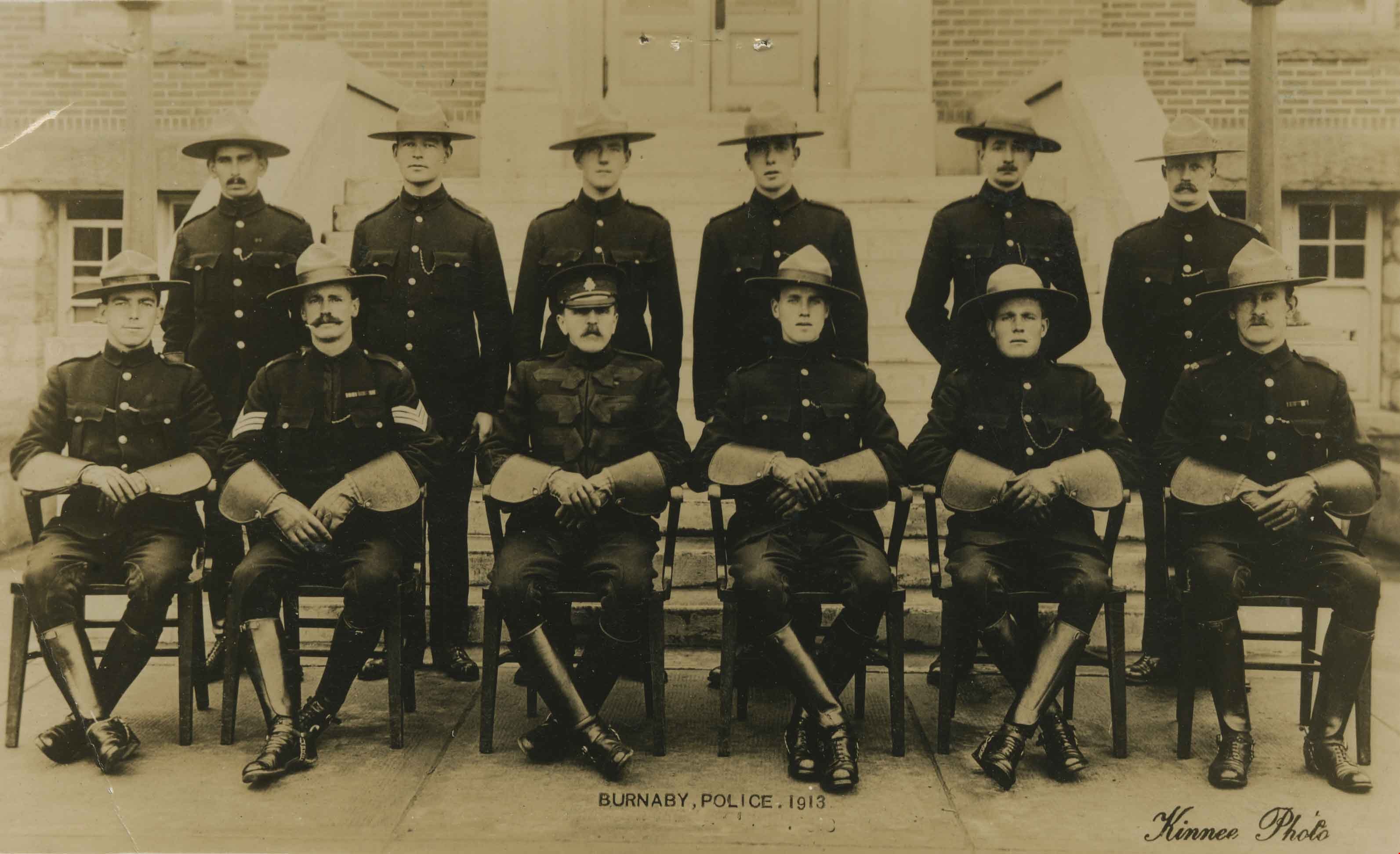
- Photographic postcard of the Burnaby Mounted Police in dress uniform, complete with gauntlets and English riding boots. The officers are seated and standing in two rows in front of the Burnaby Municipal Hall at Kingsway and Edmonds. Standing in the back row are; E.N. Senior, A.W. James, Peter Kelsb…
- Repository
- City of Burnaby Archives
- Date
- 1913
- Collection/Fonds
- Burnaby Historical Society fonds
- Subseries
- Photographs subseries
- Physical Description
- 1 photograph : sepia postcard ; 8.5 x 13.5 cm
- Description Level
- Item
- Record No.
- 255-001
- Access Restriction
- No restrictions
- Reproduction Restriction
- No known restrictions
- Accession Number
- BHS1991-14
- Scope and Content
- Photographic postcard of the Burnaby Mounted Police in dress uniform, complete with gauntlets and English riding boots. The officers are seated and standing in two rows in front of the Burnaby Municipal Hall at Kingsway and Edmonds. Standing in the back row are; E.N. Senior, A.W. James, Peter Kelsberg, George Jeffery, W.F. Nicholson. Seated in the front row are; R.L. Doidge, Sergeant J.H. Lynne, Chief William Parkinson, R. Kenderson, R.J. Woolens, and D.S. Wright.
- Names
- Burnaby Municipal Police
- Doidge, R.L.
- Kelsberg, Peter
- Woolens, Jack
- Senior, E.N.
- Jeffery, George
- Nicholson, W.F.
- Lynne, J.H.
- Parkinson, Chief William
- Kenderson, R.
- Wright, D.S.
- Burnaby City Hall
- Media Type
- Photograph
- Notes
- Title based on contents of photograph
- Photographer identified as "Kinnee"
- Geographic Access
- Kingsway
- Edmonds Street
- Historic Neighbourhood
- Edmonds (Historic Neighbourhood)
- Planning Study Area
- Stride Avenue Area
Images
Burnaby Municipal Police
https://search.heritageburnaby.ca/link/museumdescription24
- Repository
- Burnaby Village Museum
- Date
- 1913
- Collection/Fonds
- Burnaby Village Museum Photograph collection
- Description Level
- Item
- Physical Description
- 1 photograph : b&w ; 26.5 x 33.5 cm (sight) print in frame 29 x 36 cm
- Scope and Content
- Photograph of the Burnaby Mounted Police in dress uniform, complete with gauntlets and English riding boots. The officers are seated and standing in two rows in front of the Burnaby Municipal Hall at Kingsway and Edmonds. Standing in the back row are; E.N. Senior, A.W. James, Peter Kelsberg, G. Jef…
- Repository
- Burnaby Village Museum
- Collection/Fonds
- Burnaby Village Museum Photograph collection
- Description Level
- Item
- Physical Description
- 1 photograph : b&w ; 26.5 x 33.5 cm (sight) print in frame 29 x 36 cm
- Scope and Content
- Photograph of the Burnaby Mounted Police in dress uniform, complete with gauntlets and English riding boots. The officers are seated and standing in two rows in front of the Burnaby Municipal Hall at Kingsway and Edmonds. Standing in the back row are; E.N. Senior, A.W. James, Peter Kelsberg, G. Jeffery, W.F. Nicholson. Seated in the front row are; R.L. Doidge, Sergeant J.H. Lynne, Chief William Parkinson, R. Kenderson, R.J. Woolens, and D.S. Wright.
- Names
- Burnaby Municipal Police
- Doidge, R.L.
- Kelsberg, Peter
- Woolens, Jack
- Senior, E.N.
- Jeffery, George
- Nicholson, W.F.
- Lynne, J.H.
- Parkinson, Chief William
- Kenderson, R.
- Wright, D.S.
- Burnaby City Hall
- Geographic Access
- Kingsway
- Edmonds Street
- Accession Code
- HV971.40.1
- Access Restriction
- No restrictions
- Reproduction Restriction
- No known restrictions
- Date
- 1913
- Media Type
- Photograph
- Historic Neighbourhood
- Edmonds (Historic Neighbourhood)
- Planning Study Area
- Stride Avenue Area
- Scan Resolution
- 300
- Scan Date
- 15/8/2006
- Scale
- 100
- Photographer
- Kinnee
- Notes
- Title based on contents of photograph
Images
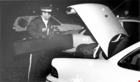
Police Officer
https://search.heritageburnaby.ca/link/archivedescription80741
- Repository
- City of Burnaby Archives
- Date
- November 19, 1997
- Collection/Fonds
- Burnaby NewsLeader photograph collection
- Description Level
- Item
- Physical Description
- 1 photograph : b&w ; 13.5 x 22 cm
- Scope and Content
- Photograph of Burnaby Royal Canadian Mounted Police officer putting a rifle case in the trunk of his police car.
- Repository
- City of Burnaby Archives
- Date
- November 19, 1997
- Collection/Fonds
- Burnaby NewsLeader photograph collection
- Physical Description
- 1 photograph : b&w ; 13.5 x 22 cm
- Description Level
- Item
- Record No.
- 535-1003
- Access Restriction
- No restrictions
- Reproduction Restriction
- No reproduction permitted
- Accession Number
- 2012-11
- Scope and Content
- Photograph of Burnaby Royal Canadian Mounted Police officer putting a rifle case in the trunk of his police car.
- Media Type
- Photograph
- Photographer
- Ray, Steve
- Notes
- Title based on contents of photograph
- Note in black ink on recto of photograph reads: "2617 Bby C Steve / Bby 3 90%"
- Trim marks and/or reproduction instructions on recto (scan is cropped)
Images

![Police Officer, [between 1995 and 1998] thumbnail](/media/hpo/_Data/_Archives_Images/_Unrestricted/535/535-1430.jpg?width=280)
Police Officer
https://search.heritageburnaby.ca/link/archivedescription81286
- Repository
- City of Burnaby Archives
- Date
- [between 1995 and 1998]
- Collection/Fonds
- Burnaby NewsLeader photograph collection
- Description Level
- Item
- Physical Description
- 1 photograph : b&w ; 24 x 16 cm
- Scope and Content
- Photograph of a Royal Canadian Mounted Police Constable demonstrating a security device on a door.
- Repository
- City of Burnaby Archives
- Date
- [between 1995 and 1998]
- Collection/Fonds
- Burnaby NewsLeader photograph collection
- Physical Description
- 1 photograph : b&w ; 24 x 16 cm
- Description Level
- Item
- Record No.
- 535-1430
- Access Restriction
- No restrictions
- Reproduction Restriction
- No reproduction permitted
- Accession Number
- 2012-11
- Scope and Content
- Photograph of a Royal Canadian Mounted Police Constable demonstrating a security device on a door.
- Media Type
- Photograph
- Photographer
- Ponne, Simone
- Notes
- Title based on contents of photograph
- Note in black ink on recto of photograph reads: "763 Bby Simone 72% Bby p. 9"
- Trim marks and/or reproduction instructions on recto (scan is cropped)
Images
![Police Officer, [between 1995 and 1998] thumbnail](/media/hpo/_Data/_Archives_Images/_Unrestricted/535/535-1430.jpg)
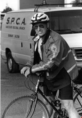
Richard Crookes
https://search.heritageburnaby.ca/link/archivedescription80530
- Repository
- City of Burnaby Archives
- Date
- July 6, 1997
- Collection/Fonds
- Burnaby NewsLeader photograph collection
- Description Level
- Item
- Physical Description
- 1 photograph : b&w ; 23 x 15.5 cm
- Scope and Content
- Photograph of Richard Crookes, a British Columbia Society for the Prevention of Cruelty to Animals(BCSPCA) bike patrol worker on his bike in front of a SPCA van..
- Repository
- City of Burnaby Archives
- Date
- July 6, 1997
- Collection/Fonds
- Burnaby NewsLeader photograph collection
- Physical Description
- 1 photograph : b&w ; 23 x 15.5 cm
- Description Level
- Item
- Record No.
- 535-0808
- Access Restriction
- No restrictions
- Reproduction Restriction
- No reproduction permitted
- Accession Number
- 2012-11
- Scope and Content
- Photograph of Richard Crookes, a British Columbia Society for the Prevention of Cruelty to Animals(BCSPCA) bike patrol worker on his bike in front of a SPCA van..
- Names
- Crookes, Richard
- Media Type
- Photograph
- Photographer
- Bartel, Mario
- Notes
- Title based on contents of photograph
- Note in black and blue ink on recto of photograph reads: "Bby - 5 - 54% / Bby - 1 25% / 1527 Bby Mario"
- Trim marks and/or reproduction instructions on recto (scan is cropped)
Images

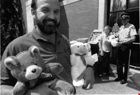
Rick Pennington, Katharine Jackson and Doug Wells
https://search.heritageburnaby.ca/link/archivedescription80544
- Repository
- City of Burnaby Archives
- Date
- July 13, 1997
- Collection/Fonds
- Burnaby NewsLeader photograph collection
- Description Level
- Item
- Physical Description
- 1 photograph : b&w ; 15.5 x 22.5 cm
- Scope and Content
- Photograph of Rick Pennington of Mundy’s Towing, presenting Burnaby Royal Canadian Mounted Police Victim Services representatives Katharine Jackson and Constable Doug Wells with teddy bears.
- Repository
- City of Burnaby Archives
- Date
- July 13, 1997
- Collection/Fonds
- Burnaby NewsLeader photograph collection
- Physical Description
- 1 photograph : b&w ; 15.5 x 22.5 cm
- Description Level
- Item
- Record No.
- 535-0821
- Access Restriction
- No restrictions
- Reproduction Restriction
- No reproduction permitted
- Accession Number
- 2012-11
- Scope and Content
- Photograph of Rick Pennington of Mundy’s Towing, presenting Burnaby Royal Canadian Mounted Police Victim Services representatives Katharine Jackson and Constable Doug Wells with teddy bears.
- Media Type
- Photograph
- Photographer
- Ray, Steve
- Notes
- Title based on contents of photograph
- Note in black ink on recto of photograph reads: "1547 Steve Bby / Bby - 9 56%"
- Trim marks and/or reproduction instructions on recto (scan is cropped)
Images

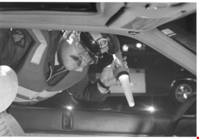
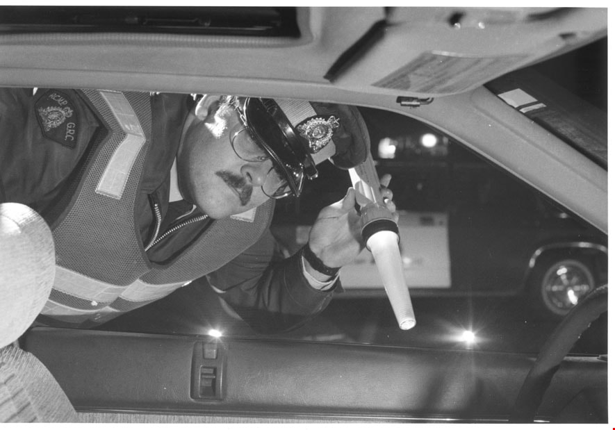
Royal Canadian Mounted Police officer
https://search.heritageburnaby.ca/link/archivedescription79814
- Repository
- City of Burnaby Archives
- Date
- December 22, 1996
- Collection/Fonds
- Burnaby NewsLeader photograph collection
- Description Level
- Item
- Physical Description
- 1 photograph : b&w ; 16 x 23 cm
- Scope and Content
- Photograph of a Royal Canadian Mounted Police officer with a flashlight looking into a car.
- Repository
- City of Burnaby Archives
- Date
- December 22, 1996
- Collection/Fonds
- Burnaby NewsLeader photograph collection
- Physical Description
- 1 photograph : b&w ; 16 x 23 cm
- Description Level
- Item
- Record No.
- 535-0532
- Access Restriction
- No restrictions
- Reproduction Restriction
- No reproduction permitted
- Accession Number
- 2012-11
- Scope and Content
- Photograph of a Royal Canadian Mounted Police officer with a flashlight looking into a car.
- Media Type
- Photograph
- Notes
- Title based on contents of photograph
- Note in black and blue ink on recto of photograph reads: "Bby File photo / 49% Bby 10"
- Trim marks and/or reproduction instructions on recto (scan is cropped)
Images
Corporal Cameron of the North West mounted police: a tale of the Macleod Trail
https://search.heritageburnaby.ca/link/museumlibrary5987
- Repository
- Burnaby Village Museum
- Author
- Connor, Ralph, 1860-1937
- Publication Date
- c1912
- Call Number
- 813.5 RAL
- Repository
- Burnaby Village Museum
- Collection
- Special Collection
- Material Type
- Book
- Accession Code
- BV014.29.2
- Call Number
- 813.5 RAL
- Author
- Connor, Ralph, 1860-1937
- Place of Publication
- Toronto, Ont.
- Publisher
- Westminster Co.
- Publication Date
- c1912
- Physical Description
- 454 p. : 19 cm.
- Inscription
- "Allen Seager" [handwritten on title page]
- Library Subject (LOC)
- Fiction--20th century
- Police
- Notes
- Author name is a nom de plume

Mancatcher
https://search.heritageburnaby.ca/link/museumlibrary4933
- Repository
- Burnaby Village Museum
- Author
- Fossum, Jack, 1905-
- Edition
- 1st ed.
- Publication Date
- 1990
- Call Number
- 971 FOS
- Repository
- Burnaby Village Museum
- Collection
- Special Collection
- Material Type
- Book
- Accession Code
- BV004.23.61
- ISBN
- 092176202X
- Call Number
- 971 FOS
- Edition
- 1st ed.
- Author
- Fossum, Jack, 1905-
- Place of Publication
- [Comox, B.C.]
- Publisher
- Lindsay Press
- Publication Date
- 1990
- Printer
- Friesen & Sons
- Physical Description
- 227 p. : ill. ; 22 cm.
- Inscription
- Bookplate on front pastedown reads "Property of Ted Brue" "from daughter" "Janette Jan-1992" [handwritten in blue ink]
- Notes
- "An immigrant's story of logging, policing and pioneering in the Canadian west" -cover
The way it was : fifty years of RCMP memories : early twenties to early seventies
https://search.heritageburnaby.ca/link/museumlibrary3856
- Repository
- Burnaby Village Museum
- Collection
- Special Collection
- Material Type
- Book
- Accession Code
- BV004.23.62
- Call Number
- 971 SAU
- Author
- Saul, Don
- Contributor
- Hertzog, Ernie
- Spalding, Frank
- Willes, Ed
- Place of Publication
- [Victoria, B.C.]
- Publisher
- Victoria Division, RCMP Veterans Association
- Publication Date
- c1990
- Printer
- Hemlock Printers
- Physical Description
- 215 p. : ill. ; 23 cm.
- Inscription
- Bookplate on front pastedown reads "Ted Brue" "from Anita + Don" [handwritten in blue ink] "Oct - 1991" [handwritten in blue ink on title page]
- Library Subject (LOC)
- Police
- Notes
- "Edited by Don Saul" -T.p. "Illustrations by Ernie Hertzog, Frank Spalding, Ed Willes" -T.p. "The way it was 50 years of RCMP memories" -cover