Narrow Results By
Subject
- Advertising Medium - Signs and Signboards 19
- Animals - Horses 1
- Buildings - Commercial 31
- Buildings - Commercial - Automobile Dealerships 1
- Buildings - Commercial - Bakeries 2
- Buildings - Commercial - Banks 7
- Buildings - Commercial - Drugstores 13
- Buildings - Commercial - General Stores 8
- Buildings - Commercial - Grocery Stores 26
- Buildings - Commercial - Hotels and Motels 2
- Buildings - Commercial - Malls 4
- Buildings - Commercial - Offices 6
Person / Organization
- A. MacKenzie and Company Jubilee Store 1
- Bennett, Eric Warrington Howard 1
- Bolognes, Gino 1
- British Columbia Electric Railway Company 4
- Burnaby Lake Store 1
- Burnaby Public Market 1
- Burnaby Village Museum 16
- Canada Way Food Market 2
- Canadian Pacific Railway Company 3
- Central Park Pharmacy 3
- Davis, Joseph "Joe" 1
- Dow, Fraser and Company Limited 2

Oh! Zhhu Sam
https://search.heritageburnaby.ca/link/archivedescription98681
- Repository
- City of Burnaby Archives
- Date
- 2022
- Collection/Fonds
- Disappearing Burnaby collection
- Description Level
- Item
- Physical Description
- 1 photograph (jpeg) : col.
- Scope and Content
- Photograph of the 7500 block of Edmonds Street at dusk. The photograph is taken from across Edmonds Street and depicts two commercial buildings: Oh! Zzhu Sam Korean Restaurant and the European Butcher Boy Delicatessen & Grocery. Oh! Zzhu Sam, located at 7506 Edmonds Street, was constructed in 1976.…
- Repository
- City of Burnaby Archives
- Date
- 2022
- Collection/Fonds
- Disappearing Burnaby collection
- Physical Description
- 1 photograph (jpeg) : col.
- Description Level
- Item
- Record No.
- 634-028
- Access Restriction
- No restrictions
- Reproduction Restriction
- No restrictions
- Accession Number
- 2022-14
- Scope and Content
- Photograph of the 7500 block of Edmonds Street at dusk. The photograph is taken from across Edmonds Street and depicts two commercial buildings: Oh! Zzhu Sam Korean Restaurant and the European Butcher Boy Delicatessen & Grocery. Oh! Zzhu Sam, located at 7506 Edmonds Street, was constructed in 1976. Residential houses border the restaurant and grocery store, and a bus shelter, municipal garbage can, and the restaurant's illuminated neon sign stand in front of the buildings.
- Subjects
- Buildings - Commercial
- Buildings - Commercial - Grocery Stores
- Buildings - Commercial - Restaurants
- Media Type
- Photograph
- Photographer
- Cheung, Nakita
- Notes
- Title taken from the associated blog post
- Associated blog post: https://disappearingburnaby.wordpress.com/2022/07/29/oh-zzhu-sam/
- Geographic Access
- Edmonds Street
- Street Address
- 7506 Edmonds Street
- Historic Neighbourhood
- Edmonds (Historic Neighbourhood)
- Planning Study Area
- Edmonds Area
Images


Trafalgar Market
https://search.heritageburnaby.ca/link/archivedescription98665
- Repository
- City of Burnaby Archives
- Date
- 2022
- Collection/Fonds
- Disappearing Burnaby collection
- Description Level
- Item
- Physical Description
- 1 photograph (jpeg) : col.
- Scope and Content
- Photograph of the intersection of Imperial Street and Sussex Avenue at night and in the rain. The photograph shows the Trafalgar Market grocery store (located at 4398 Imperial Street; the building was constructed in 1940) on the corner, with a large display of flowers for sale under the awning in f…
- Repository
- City of Burnaby Archives
- Date
- 2022
- Collection/Fonds
- Disappearing Burnaby collection
- Physical Description
- 1 photograph (jpeg) : col.
- Description Level
- Item
- Record No.
- 634-012
- Access Restriction
- No restrictions
- Reproduction Restriction
- No restrictions
- Accession Number
- 2022-14
- Scope and Content
- Photograph of the intersection of Imperial Street and Sussex Avenue at night and in the rain. The photograph shows the Trafalgar Market grocery store (located at 4398 Imperial Street; the building was constructed in 1940) on the corner, with a large display of flowers for sale under the awning in front of the store. The street and traffic lights are reflected in the puddles on the road, and cars and other businesses are visible along Imperial Street.
- Subjects
- Buildings - Commercial
- Buildings - Commercial - Grocery Stores
- Buildings - Commercial - Stores
- Geographic Features - Roads
- Media Type
- Photograph
- Photographer
- Cheung, Nakita
- Notes
- Title taken from the associated blog post
- Associated blog post: https://disappearingburnaby.wordpress.com/2022/02/20/imperial-manor-2/
- Geographic Access
- Imperial Street
- Sussex Avenue
- Street Address
- 4398 Imperial Street
- Historic Neighbourhood
- Central Park (Historic Neighbourhood)
- Planning Study Area
- Sussex-Nelson Area
Images


Canadian Food Market
https://search.heritageburnaby.ca/link/archivedescription98666
- Repository
- City of Burnaby Archives
- Date
- 2022
- Collection/Fonds
- Disappearing Burnaby collection
- Description Level
- Item
- Physical Description
- 1 photograph (jpeg) : col.
- Scope and Content
- Photograph of the exterior of the Canadian Food Market, taken from across Imperial Street at night. The grocery store is located at 4378 Imperial Street and the building was constructed in 1962. A large display of plants and flowers stands in front of the store and is illuminated by bright lights.
- Repository
- City of Burnaby Archives
- Date
- 2022
- Collection/Fonds
- Disappearing Burnaby collection
- Physical Description
- 1 photograph (jpeg) : col.
- Description Level
- Item
- Record No.
- 634-013
- Access Restriction
- No restrictions
- Reproduction Restriction
- No restrictions
- Accession Number
- 2022-14
- Scope and Content
- Photograph of the exterior of the Canadian Food Market, taken from across Imperial Street at night. The grocery store is located at 4378 Imperial Street and the building was constructed in 1962. A large display of plants and flowers stands in front of the store and is illuminated by bright lights.
- Media Type
- Photograph
- Photographer
- Cheung, Nakita
- Notes
- Title taken from the associated blog post
- Associated blog post: https://disappearingburnaby.wordpress.com/2022/02/20/imperial-manor-2/
- Geographic Access
- Imperial Street
- Street Address
- 4378 Imperial Street
- Historic Neighbourhood
- Central Park (Historic Neighbourhood)
- Planning Study Area
- Sussex-Nelson Area
Images

![Carnarvon Street Building, [1912] thumbnail](/media/hpo/_Data/_Archives_Images/_Unrestricted/477/477-939.jpg?width=280)
Carnarvon Street Building
https://search.heritageburnaby.ca/link/archivedescription66213
- Repository
- City of Burnaby Archives
- Date
- [1912]
- Collection/Fonds
- Peers Family and Hill Family fonds
- Description Level
- Item
- Physical Description
- 1 photograph : sepia ; 19.5 x 24 cm
- Scope and Content
- Photograph of the Carnarvon Street building in New Westminster, built by Claude Hill and E. B. Wetenhall (architect). Three cars can be seen on the street, one with two unidentified men seated inside. A note on the back of the photograph indicates that the building in the background is the New We…
- Repository
- City of Burnaby Archives
- Date
- [1912]
- Collection/Fonds
- Peers Family and Hill Family fonds
- Physical Description
- 1 photograph : sepia ; 19.5 x 24 cm
- Description Level
- Item
- Record No.
- 477-939
- Access Restriction
- No restrictions
- Reproduction Restriction
- No known restrictions
- Accession Number
- 2007-12
- Scope and Content
- Photograph of the Carnarvon Street building in New Westminster, built by Claude Hill and E. B. Wetenhall (architect). Three cars can be seen on the street, one with two unidentified men seated inside. A note on the back of the photograph indicates that the building in the background is the New Westminster Opera House and a sign on the building in the foreground reads "Ford Cars - Fraser Valley Motor Co. Limited."
- Subjects
- Transportation - Automobiles
- Buildings - Commercial
- Buildings - Commercial - Automobile Dealerships
- Media Type
- Photograph
- Notes
- Title based on contents of photograph
- Note on verso reads: "Carnarvon St. Bldg. / built by L.C. Hill & EB Wetenhall (architect) / old New Westminster Opera House / r. background - / app. 1912 -"
Images
![Carnarvon Street Building, [1912] thumbnail](/media/hpo/_Data/_Archives_Images/_Unrestricted/477/477-939.jpg)
![Gwendoline Goodridge standing in doorway of Goodridge store, [191-] thumbnail](/media/hpo/_Data/_BVM_Images/2023/2023_0015_0003_001.jpg?width=280)
Gwendoline Goodridge standing in doorway of Goodridge store
https://search.heritageburnaby.ca/link/museumdescription20277
- Repository
- Burnaby Village Museum
- Date
- [191-]
- Collection/Fonds
- Burnaby Village Museum Photograph collection
- Description Level
- Item
- Physical Description
- 1 photograph : b&w negative ; 12.5 x 10 cm
- Scope and Content
- Photograph of Gwendoline Elston "Gwen" (Goodridge) Lister standing in the doorway of the Goodridge grocey store and post office located on Hastings Street in Burnaby. Signage on the windows and on the front of the store identify some of the trademarks of products sold in the store including "Royal …
- Repository
- Burnaby Village Museum
- Collection/Fonds
- Burnaby Village Museum Photograph collection
- Description Level
- Item
- Physical Description
- 1 photograph : b&w negative ; 12.5 x 10 cm
- Scope and Content
- Photograph of Gwendoline Elston "Gwen" (Goodridge) Lister standing in the doorway of the Goodridge grocey store and post office located on Hastings Street in Burnaby. Signage on the windows and on the front of the store identify some of the trademarks of products sold in the store including "Royal Crown Soap", "Salada Tea" and "Kellog's Cornflakes". Signage below window on right reads "POST OFFICE".
- Subjects
- Buildings - Commercial
- Buildings - Commercial - Grocery Stores
- Buildings - Public - Post Offices
- Geographic Access
- Hastings Street
- Accession Code
- BV023.15.3
- Access Restriction
- No restrictions
- Reproduction Restriction
- No known restrictions
- Date
- [191-]
- Media Type
- Photograph
- Scan Resolution
- 3200
- Scan Date
- 2023-09-21
- Notes
- Title based on contents of photograph
- 1 b&w contact sheet accompanying
Images
![Gwendoline Goodridge standing in doorway of Goodridge store, [191-] thumbnail](/media/hpo/_Data/_BVM_Images/2023/2023_0015_0003_001.jpg)

Metrotown Station Square
https://search.heritageburnaby.ca/link/archivedescription93745
- Repository
- City of Burnaby Archives
- Date
- November 1989
- Collection/Fonds
- Grover, Elliott & Co. Ltd. fonds
- Description Level
- File
- Physical Description
- 83 photographs : col. negatives ; 35 mm + 2 computer disks ; 14 x 14 cm
- Scope and Content
- Photographs of Metrotown Station Square during construction. Businesses visible in the photographs include: Eastons, Holiday Inn, Future Shop, Great Canadian Superstore, and Toy City Consumers.
- Repository
- City of Burnaby Archives
- Date
- November 1989
- Collection/Fonds
- Grover, Elliott & Co. Ltd. fonds
- Physical Description
- 83 photographs : col. negatives ; 35 mm + 2 computer disks ; 14 x 14 cm
- Description Level
- File
- Record No.
- 622-030
- Access Restriction
- No restrictions
- Reproduction Restriction
- No restrictions
- Accession Number
- 2017-39
- Scope and Content
- Photographs of Metrotown Station Square during construction. Businesses visible in the photographs include: Eastons, Holiday Inn, Future Shop, Great Canadian Superstore, and Toy City Consumers.
- Media Type
- Photograph
- Notes
- Transcribed title
- Title transcribed from print envelopes photographs were originally housed in
- File no. 89-512-B
- Computer disks are labelled "Station Square Metro Town Nov /89". Computer disk envelopes are labelled "Suite 660-1380 Burrard ST / Van, BC"
- Geographic Access
- McKay Avenue
- Street Address
- 6200 McKay Avenue
- Historic Neighbourhood
- Central Park (Historic Neighbourhood)
- Planning Study Area
- Maywood Area
Images


On On Wonton House
https://search.heritageburnaby.ca/link/archivedescription98670
- Repository
- City of Burnaby Archives
- Date
- 2022
- Collection/Fonds
- Disappearing Burnaby collection
- Description Level
- Item
- Physical Description
- 1 photograph (jpeg) : col.
- Scope and Content
- Photograph of the exterior of the On On Wonton House restaurant, located at 5640 Kingsway. The photograph is taken from across Kingsway at night. The building, which was constructed in 1959, is lit up with lights and a bright sign, and several cars are parked in the lot in front of the restaurant.
- Repository
- City of Burnaby Archives
- Date
- 2022
- Collection/Fonds
- Disappearing Burnaby collection
- Physical Description
- 1 photograph (jpeg) : col.
- Description Level
- Item
- Record No.
- 634-017
- Access Restriction
- No restrictions
- Reproduction Restriction
- No restrictions
- Accession Number
- 2022-14
- Scope and Content
- Photograph of the exterior of the On On Wonton House restaurant, located at 5640 Kingsway. The photograph is taken from across Kingsway at night. The building, which was constructed in 1959, is lit up with lights and a bright sign, and several cars are parked in the lot in front of the restaurant.
- Media Type
- Photograph
- Photographer
- Cheung, Nakita
- Notes
- Title taken from the associated blog post
- Associated blog post: https://disappearingburnaby.wordpress.com/2022/06/06/on-on-wonton-house/
- Geographic Access
- Kingsway
- Street Address
- 5640 Kingsway
- Historic Neighbourhood
- Central Park (Historic Neighbourhood)
- Planning Study Area
- Windsor Area
Images

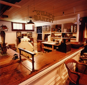
Willie's bakery
https://search.heritageburnaby.ca/link/museumdescription12951
- Repository
- Burnaby Village Museum
- Date
- 1984
- Collection/Fonds
- Century Park Museum Association fonds
- Description Level
- Item
- Physical Description
- 1 photograph : col. ; 12.5 x 12.5 cm
- Scope and Content
- Photograph of "Willie's Bakery" inside the Burnaby Village Museum General Store building. A long wooden counter divides the public from the work area. Shelving and work tables behind the counter hold various baking supplies and equipment.
- Repository
- Burnaby Village Museum
- Collection/Fonds
- Century Park Museum Association fonds
- Description Level
- Item
- Physical Description
- 1 photograph : col. ; 12.5 x 12.5 cm
- Scope and Content
- Photograph of "Willie's Bakery" inside the Burnaby Village Museum General Store building. A long wooden counter divides the public from the work area. Shelving and work tables behind the counter hold various baking supplies and equipment.
- Names
- Burnaby Village Museum
- Accession Code
- BV020.5.666
- Access Restriction
- No restrictions
- Reproduction Restriction
- No known restrictions
- Date
- 1984
- Media Type
- Photograph
- Related Material
- See b&w photograph: BV020.5.699
- Scan Resolution
- 600
- Scan Date
- 9-Apr-20
- Scale
- 100
- Notes
- Title based on contents of photograph
Images

3000, 3100, 3200 Beta Ave
https://search.heritageburnaby.ca/link/archivedescription93739
- Repository
- City of Burnaby Archives
- Date
- 1989
- Collection/Fonds
- Grover, Elliott & Co. Ltd. fonds
- Description Level
- File
- Physical Description
- 40 photographs : col. negatives ; 35 mm
- Scope and Content
- Photographs of the commercial buildings and loading bays located at 3000, 3100, and 3200 Beta Avenue.
- Repository
- City of Burnaby Archives
- Date
- 1989
- Collection/Fonds
- Grover, Elliott & Co. Ltd. fonds
- Physical Description
- 40 photographs : col. negatives ; 35 mm
- Description Level
- File
- Record No.
- 622-024
- Access Restriction
- No restrictions
- Reproduction Restriction
- No restrictions
- Accession Number
- 2017-39
- Scope and Content
- Photographs of the commercial buildings and loading bays located at 3000, 3100, and 3200 Beta Avenue.
- Subjects
- Buildings - Commercial
- Media Type
- Photograph
- Notes
- Transcribed title
- Title transcribed from print envelope photographs were originally housed in
- File no. 89-214-B
- Geographic Access
- Beta Avenue
- Street Address
- 3000 Beta Avenue
- 3100 Beta Avenue
- 3200 Beta Avenue
- Planning Study Area
- Douglas-Gilpin Area
3650 Bonneville Place
https://search.heritageburnaby.ca/link/archivedescription93737
- Repository
- City of Burnaby Archives
- Date
- March 1989
- Collection/Fonds
- Grover, Elliott & Co. Ltd. fonds
- Description Level
- File
- Physical Description
- 8 photographs : col. ; 10 cm x 15 cm
- Scope and Content
- Photographs of the commercial complex located at 3650 Bonneville Place. Phase I of the complex is complete and Phase II is under construction. Businesses visible in the photographs include Four Seasons Greenhouses and Shaw.
- Repository
- City of Burnaby Archives
- Date
- March 1989
- Collection/Fonds
- Grover, Elliott & Co. Ltd. fonds
- Physical Description
- 8 photographs : col. ; 10 cm x 15 cm
- Description Level
- File
- Record No.
- 622-022
- Access Restriction
- No restrictions
- Reproduction Restriction
- No restrictions
- Accession Number
- 2017-39
- Scope and Content
- Photographs of the commercial complex located at 3650 Bonneville Place. Phase I of the complex is complete and Phase II is under construction. Businesses visible in the photographs include Four Seasons Greenhouses and Shaw.
- Subjects
- Buildings - Commercial
- Construction
- Media Type
- Photograph
- Notes
- Transcribed title
- Title transcribed from sticky note adhered to photograph 622-022-1
- File no. 89-124-B
- Photograph 622-022-1 captions reads: "3650 Bonneville - south view"
- Photograph 622-022-2 caption reads: "North and east facade"
- Photograph 622-022-3 caption reads: "View north along Broadway Street; Note entry bridges"
- Photograph 622-022-4 caption reads: "Southern view along Broadway Street"
- Photograph 622-022-5 caption reads: "Front facade and main entry for Phase I"
- Photograph 622-022-6 caption reads: "Rear and loading facilities for Phase I"
- Photograph 622-022-7 caption reads: "View west to Phase II from entry driveway"
- Photograph 622-022-8 caption reads: "Site preparation for Phase I
- Photograph captions transcribed from the paper on which the photographs were originally adhered.
- Geographic Access
- Bonneville Place
- Street Address
- 3650 Bonneville Place
- Planning Study Area
- Lake City Area
5499-5495 Regent Street / 2857 Douglas Road
https://search.heritageburnaby.ca/link/archivedescription93713
- Repository
- City of Burnaby Archives
- Date
- 1987
- Collection/Fonds
- Grover, Elliott & Co. Ltd. fonds
- Description Level
- File
- Physical Description
- 24 photographs : col. negatives ; 35 mm
- Scope and Content
- Photographs of the building exterior and loading bays of Loomis, located at 5499 and 5495 Regent Street, and of 2857 Douglas Road. 5499 and 5495 Regent Street are addresses that no longer exist; the current address is 5491 Regent Street.
- Repository
- City of Burnaby Archives
- Date
- 1987
- Collection/Fonds
- Grover, Elliott & Co. Ltd. fonds
- Physical Description
- 24 photographs : col. negatives ; 35 mm
- Description Level
- File
- Record No.
- 622-002
- Access Restriction
- No restrictions
- Reproduction Restriction
- No restrictions
- Accession Number
- 2017-39
- Scope and Content
- Photographs of the building exterior and loading bays of Loomis, located at 5499 and 5495 Regent Street, and of 2857 Douglas Road. 5499 and 5495 Regent Street are addresses that no longer exist; the current address is 5491 Regent Street.
- Media Type
- Photograph
- Notes
- Transcribed title
- Title transcribed from original print envelope
- File no. 87-133-B
- Geographic Access
- Douglas Road
- Regent Street
- Street Address
- 2857 Douglas Road
- 5491 Regent Street
- Historic Neighbourhood
- Burnaby Lake (Historic Neighbourhood)
- Planning Study Area
- Dawson-Delta Area
5608 to 5628 Imperial Street
https://search.heritageburnaby.ca/link/archivedescription93730
- Repository
- City of Burnaby Archives
- Date
- 1989
- Collection/Fonds
- Grover, Elliott & Co. Ltd. fonds
- Description Level
- File
- Physical Description
- 16 photographs : col. negatives ; 35 mm
- Scope and Content
- Photographs of the commerical properties located between 5608 and 5628 Imperial Street and the intersection at Imperial Street and MacPherson Avenue. Businesses visible in the photographs include Galaxie Collision, Minit-tune, and Canadian Cash and Carry Tire Centre.
- Repository
- City of Burnaby Archives
- Date
- 1989
- Collection/Fonds
- Grover, Elliott & Co. Ltd. fonds
- Physical Description
- 16 photographs : col. negatives ; 35 mm
- Description Level
- File
- Record No.
- 622-018
- Access Restriction
- No restrictions
- Reproduction Restriction
- No restrictions
- Accession Number
- 2017-39
- Scope and Content
- Photographs of the commerical properties located between 5608 and 5628 Imperial Street and the intersection at Imperial Street and MacPherson Avenue. Businesses visible in the photographs include Galaxie Collision, Minit-tune, and Canadian Cash and Carry Tire Centre.
- Media Type
- Photograph
- Photographer
- Young, J.
- Notes
- Transcribed title
- Title transcribed from original print envelope
- Geographic Access
- Imperial Street
- MacPherson Avenue
- Street Address
- 5608 Imperial Street
- 5628 Imperial Street
- Historic Neighbourhood
- Central Park (Historic Neighbourhood)
- Planning Study Area
- Windsor Area
5621 Imperial Street
https://search.heritageburnaby.ca/link/archivedescription93712
- Repository
- City of Burnaby Archives
- Date
- 1987
- Collection/Fonds
- Grover, Elliott & Co. Ltd. fonds
- Description Level
- File
- Physical Description
- 8 photographs : col. ; 10 cm x 15 cm
- Scope and Content
- Photographs of the exterior of the commerical property located at 5621 Imperial Street.
- Repository
- City of Burnaby Archives
- Date
- 1987
- Collection/Fonds
- Grover, Elliott & Co. Ltd. fonds
- Physical Description
- 8 photographs : col. ; 10 cm x 15 cm
- Description Level
- File
- Record No.
- 622-001
- Access Restriction
- No restrictions
- Reproduction Restriction
- No restrictions
- Accession Number
- 2017-39
- Scope and Content
- Photographs of the exterior of the commerical property located at 5621 Imperial Street.
- Subjects
- Buildings - Commercial
- Media Type
- Photograph
- Notes
- Transcribed title
- Title transcribed from original print envelope
- File no. 87-056-B
- Geographic Access
- Imperial Street
- Street Address
- 5621 Imperial Street
- Historic Neighbourhood
- Central Park (Historic Neighbourhood)
- Planning Study Area
- Windsor Area
7018-7092 Lougheed Hwy [at] SW intersection w/ Bainbridge Ave
https://search.heritageburnaby.ca/link/archivedescription93715
- Repository
- City of Burnaby Archives
- Date
- 1987
- Collection/Fonds
- Grover, Elliott & Co. Ltd. fonds
- Description Level
- File
- Physical Description
- 17 photographs : col. ; 10 cm x 15 cm
- Scope and Content
- Photographs of the commercial properties located at 7018-7092 Lougheed Highway and the surrounding area. Photographs depict the buildings' exteriors, interiors, and roof. Also included in the file is one photograph of a map of Sechelt being marked up.
- Repository
- City of Burnaby Archives
- Date
- 1987
- Collection/Fonds
- Grover, Elliott & Co. Ltd. fonds
- Physical Description
- 17 photographs : col. ; 10 cm x 15 cm
- Description Level
- File
- Record No.
- 622-004
- Access Restriction
- No restrictions
- Reproduction Restriction
- No restrictions
- Accession Number
- 2017-39
- Scope and Content
- Photographs of the commercial properties located at 7018-7092 Lougheed Highway and the surrounding area. Photographs depict the buildings' exteriors, interiors, and roof. Also included in the file is one photograph of a map of Sechelt being marked up.
- Media Type
- Photograph
- Notes
- Transcribed title
- Title transcribed from original print envelope
- File no. 87-201-B
- Geographic Access
- Lougheed Highway
- Street Address
- 7018 Lougheed Highway
- Planning Study Area
- Government Road Area
7818 6th Street
https://search.heritageburnaby.ca/link/archivedescription93731
- Repository
- City of Burnaby Archives
- Date
- 1989
- Collection/Fonds
- Grover, Elliott & Co. Ltd. fonds
- Description Level
- File
- Physical Description
- 26 photographs : col. negatives ; 35 mm
- Scope and Content
- Photographs of the exterior of a Benjamin Moore Paints store and surrounding area. The store is located on a corner opposite Microtel and outside the store, a sign for the Skytrain Operations and Maintenance Centre is visible.
- Repository
- City of Burnaby Archives
- Date
- 1989
- Collection/Fonds
- Grover, Elliott & Co. Ltd. fonds
- Physical Description
- 26 photographs : col. negatives ; 35 mm
- Description Level
- File
- Record No.
- 622-019
- Access Restriction
- No restrictions
- Reproduction Restriction
- No restrictions
- Accession Number
- 2017-39
- Scope and Content
- Photographs of the exterior of a Benjamin Moore Paints store and surrounding area. The store is located on a corner opposite Microtel and outside the store, a sign for the Skytrain Operations and Maintenance Centre is visible.
- Media Type
- Photograph
- Notes
- Transcribed title
- Title transcribed from original print envelope
- File no. 89v-004-O
- Property address could not be confirmed at time of description.
- Geographic Access
- 6th Street
- 12th Avenue
- Street Address
- 7818 6th Street
- Historic Neighbourhood
- East Burnaby (Historic Neighbourhood)
- Planning Study Area
- Second Street Area
7973-7993 Enterprise St
https://search.heritageburnaby.ca/link/archivedescription93718
- Repository
- City of Burnaby Archives
- Date
- 1987
- Collection/Fonds
- Grover, Elliott & Co. Ltd. fonds
- Description Level
- File
- Physical Description
- 14 photographs : col. ; 10 cm x 15 cm
- Scope and Content
- Photographs of the exterior of the commercial complex located at 7973 and 7993 Enterprise Street. Businesses visible in the photographs include: Universal, Philips, Canpar, Boss Cartage, and Hercules Forwarding Ltd.
- Repository
- City of Burnaby Archives
- Date
- 1987
- Collection/Fonds
- Grover, Elliott & Co. Ltd. fonds
- Physical Description
- 14 photographs : col. ; 10 cm x 15 cm
- Description Level
- File
- Record No.
- 622-007
- Access Restriction
- No restrictions
- Reproduction Restriction
- No restrictions
- Accession Number
- 2017-39
- Scope and Content
- Photographs of the exterior of the commercial complex located at 7973 and 7993 Enterprise Street. Businesses visible in the photographs include: Universal, Philips, Canpar, Boss Cartage, and Hercules Forwarding Ltd.
- Media Type
- Photograph
- Notes
- Transcribed title
- Title transcribed from original print envelope
- File no. 87-485-B
- Geographic Access
- Enterprise Street
- Street Address
- 7973 Enterprise Street
- 7993 Enterprise Street
- Planning Study Area
- Lake City Area
![A. MacKenzie and Company Jubilee Store, [1912] thumbnail](/media/hpo/_Data/_Archives_Images/_Unrestricted/205/228-005.jpg?width=280)
A. MacKenzie and Company Jubilee Store
https://search.heritageburnaby.ca/link/archivedescription36144
- Repository
- City of Burnaby Archives
- Date
- [1912]
- Collection/Fonds
- Burnaby Historical Society fonds
- Description Level
- Item
- Physical Description
- 1 photograph : sepia ; 11.5 x 16.5 cm
- Scope and Content
- Photograph of the exterior side view of A. MacKenzie & Co / Jubilee Store. There are two men in suits standing beside a wagon, one with his hands on his hips, surveying a pile of bundles of wood that look like they have just fallen from the wagoon into the snow. A child stands at the front door of…
- Repository
- City of Burnaby Archives
- Date
- [1912]
- Collection/Fonds
- Burnaby Historical Society fonds
- Physical Description
- 1 photograph : sepia ; 11.5 x 16.5 cm
- Description Level
- Item
- Record No.
- 228-005
- Access Restriction
- No restrictions
- Reproduction Restriction
- No known restrictions
- Accession Number
- BHS1989-22
- Scope and Content
- Photograph of the exterior side view of A. MacKenzie & Co / Jubilee Store. There are two men in suits standing beside a wagon, one with his hands on his hips, surveying a pile of bundles of wood that look like they have just fallen from the wagoon into the snow. A child stands at the front door of the shop, also looking at the bundles. The store was owned by Alexander MacKenzie, (1870-1949) who arrived in Vancouver in 1907. This store later became the Matheson and Sons Market.
- Media Type
- Photograph
- Notes
- Title based on contents of photograph
- Geographic Access
- Kingsway
- Nelson Avenue
- Historic Neighbourhood
- Central Park (Historic Neighbourhood)
Images
![A. MacKenzie and Company Jubilee Store, [1912] thumbnail](/media/hpo/_Data/_Archives_Images/_Unrestricted/205/228-005.jpg)
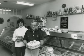
A man and woman in a deli/bakery
https://search.heritageburnaby.ca/link/archivedescription59192
- Repository
- City of Burnaby Archives
- Date
- ca. 1982
- Collection/Fonds
- Columbian Newspaper collection
- Description Level
- Item
- Physical Description
- 1 photograph : b&w ; 13 x 19 cm
- Scope and Content
- Photograph of a couple inside of a deli and bakery on Hastings Street. The man is holding a large decorated cake.
- Repository
- City of Burnaby Archives
- Date
- ca. 1982
- Collection/Fonds
- Columbian Newspaper collection
- Physical Description
- 1 photograph : b&w ; 13 x 19 cm
- Description Level
- Item
- Record No.
- 480-1510
- Access Restriction
- No restrictions
- Reproduction Restriction
- Reproduce for fair dealing purposes only
- Accession Number
- 2009-01
- Scope and Content
- Photograph of a couple inside of a deli and bakery on Hastings Street. The man is holding a large decorated cake.
- Subjects
- Buildings - Commercial - Bakeries
- Foods
- Media Type
- Photograph
- Notes
- Title based on contents of photograph
- Note on verso reads: "As is / Burnaby Today / (Hastings St Shoppers Page) / 100%"
- Geographic Access
- Hastings Street
Images
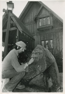
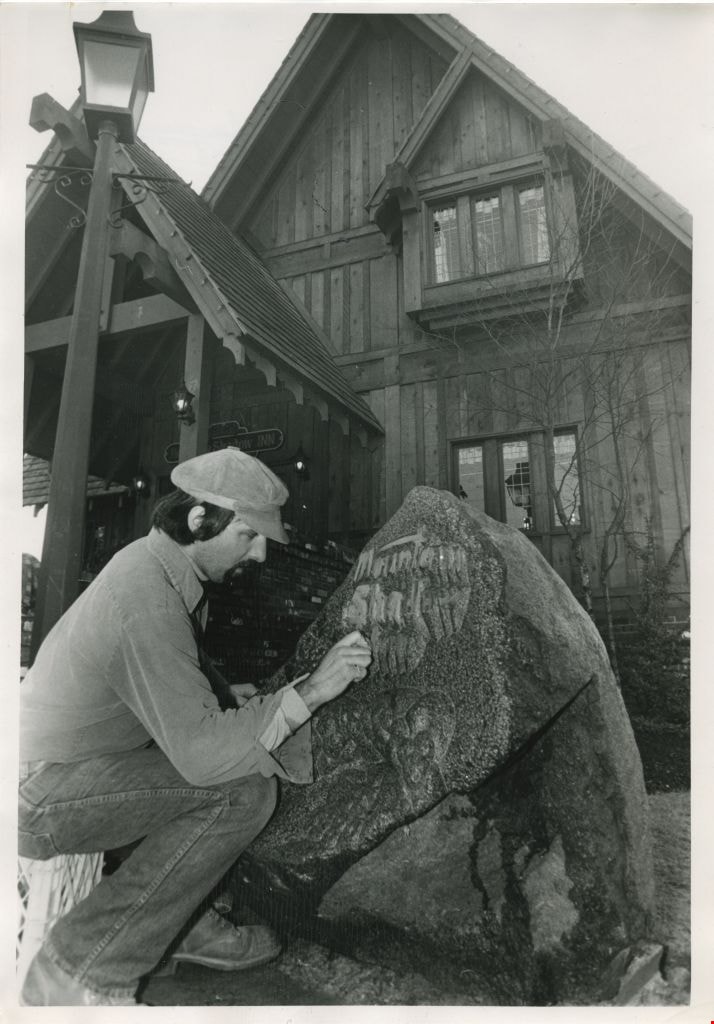
A man outside the Mountain Shadow Pub
https://search.heritageburnaby.ca/link/archivedescription58922
- Repository
- City of Burnaby Archives
- Date
- ca.1980
- Collection/Fonds
- Columbian Newspaper collection
- Description Level
- Item
- Physical Description
- 1 photograph : b&w ; 20.5 x 18 cm
- Scope and Content
- Photograph of a man outside the Mountain Shadow Pub that was located at the base of Burnaby Mountain. He appears to be rewriting the name of the pub on a rock.
- Repository
- City of Burnaby Archives
- Date
- ca.1980
- Collection/Fonds
- Columbian Newspaper collection
- Physical Description
- 1 photograph : b&w ; 20.5 x 18 cm
- Description Level
- Item
- Record No.
- 480-1373
- Access Restriction
- No restrictions
- Reproduction Restriction
- Reproduce for fair dealing purposes only
- Accession Number
- 2009-01
- Scope and Content
- Photograph of a man outside the Mountain Shadow Pub that was located at the base of Burnaby Mountain. He appears to be rewriting the name of the pub on a rock.
- Subjects
- Buildings - Commercial
- Media Type
- Photograph
- Photographer
- Hodge, Craig
- Notes
- Title based on contents of photograph
- Photographer's stamp on verso
- Note on verso reads: "page A-3 / Burnaby Today / PMT 110%"
- Geographic Access
- Burnaby Mountain Conservation Area
- Historic Neighbourhood
- Lochdale (Historic Neighbourhood)
- Planning Study Area
- Burnaby Mountain Area
Images
![Apothecary bottles and artifacts inside Burnaby Village Museum Pharmacy, [198-] thumbnail](/media/hpo/_Data/_BVM_Images/2020/2020_0004_1195_001.jpg?width=280)
Apothecary bottles and artifacts inside Burnaby Village Museum Pharmacy
https://search.heritageburnaby.ca/link/museumdescription17131
- Repository
- Burnaby Village Museum
- Date
- [198-]
- Collection/Fonds
- Century Park Museum Association fonds
- Description Level
- Item
- Physical Description
- 1 photograph : col. ; 9 x 12.5 cm
- Scope and Content
- Photograph of apothecary bottles arranged on shelving and other apothecary artifacts on display inside the Burnaby Village Museum Pharmacy exhibit.
- Repository
- Burnaby Village Museum
- Collection/Fonds
- Century Park Museum Association fonds
- Description Level
- Item
- Physical Description
- 1 photograph : col. ; 9 x 12.5 cm
- Scope and Content
- Photograph of apothecary bottles arranged on shelving and other apothecary artifacts on display inside the Burnaby Village Museum Pharmacy exhibit.
- Subjects
- Buildings - Commercial - Drugstores
- Names
- Burnaby Village Museum
- Accession Code
- BV020.4.1195
- Access Restriction
- No restrictions
- Reproduction Restriction
- May be restricted by third party rights
- Date
- [198-]
- Media Type
- Photograph
- Scan Resolution
- 600
- Notes
- Title based on contents of photograph
- Stamp on verso of photograph reads: "598_42NNN22"
Images
![Apothecary bottles and artifacts inside Burnaby Village Museum Pharmacy, [198-] thumbnail](/media/hpo/_Data/_BVM_Images/2020/2020_0004_1195_001.jpg)