Narrow Results By
Subject
- Academic Disciplines 1
- Accidents 2
- Accidents - Train Accidents 7
- Adminstrative Groups - Committees 4
- Adornment - Jewelry 1
- Advertising Medium 2
- Advertising Medium - Flyer 4
- Advertising Medium - Poster
- Advertising Medium - Signs and Signboards 81
- Aerial Photographs
- Agricultural Tools and Equipment 1
- Agricultural Tools and Equipment - Gardening Equipment 3

Corner of McGill and Gilmore
https://search.heritageburnaby.ca/link/archivedescription78894
- Repository
- City of Burnaby Archives
- Date
- September 5, 1976
- Collection/Fonds
- Burnaby Public Library Contemporary Visual Archive Project
- Description Level
- Item
- Physical Description
- 1 photograph : b&w ; 11 x 16 cm mounted on cardboard
- Scope and Content
- Photograph shows view of houses and the North Shore from the corner of McGill Street and Gilmore Avenue.
- Repository
- City of Burnaby Archives
- Date
- September 5, 1976
- Collection/Fonds
- Burnaby Public Library Contemporary Visual Archive Project
- Physical Description
- 1 photograph : b&w ; 11 x 16 cm mounted on cardboard
- Description Level
- Item
- Record No.
- 556-019
- Access Restriction
- No restrictions
- Reproduction Restriction
- Reproduce for fair dealing purposes only
- Accession Number
- 2013-13
- Scope and Content
- Photograph shows view of houses and the North Shore from the corner of McGill Street and Gilmore Avenue.
- Subjects
- Aerial Photographs
- Media Type
- Photograph
- Notes
- Scope note taken directly from BPL photograph description.
- 1 b&w copy negative : 10 x 12.5 cm accompanying
- Photographers identified by surnames only: Carr and Vardeman
- Geographic Access
- McGill Street
- Gilmore Avenue
- Historic Neighbourhood
- Vancouver Heights (Historic Neighbourhood)
- Planning Study Area
- Burnaby Heights Area
Images


Edmonds Neighbourhood
https://search.heritageburnaby.ca/link/archivedescription79945
- Repository
- City of Burnaby Archives
- Date
- October 20, 1976
- Collection/Fonds
- Burnaby Public Library Contemporary Visual Archive Project
- Description Level
- Item
- Physical Description
- 1 photograph : b&w ; 11 x 16 cm mounted on cardboard
- Scope and Content
- Photograph shows a view of the neighbourhood south of Kingsway and Edmonds Street. The photo was taken from Hall Towers.
- Repository
- City of Burnaby Archives
- Date
- October 20, 1976
- Collection/Fonds
- Burnaby Public Library Contemporary Visual Archive Project
- Physical Description
- 1 photograph : b&w ; 11 x 16 cm mounted on cardboard
- Description Level
- Item
- Record No.
- 556-516
- Access Restriction
- No restrictions
- Reproduction Restriction
- Reproduce for fair dealing purposes only
- Accession Number
- 2013-13
- Scope and Content
- Photograph shows a view of the neighbourhood south of Kingsway and Edmonds Street. The photo was taken from Hall Towers.
- Subjects
- Aerial Photographs
- Media Type
- Photograph
- Photographer
- Ross, Martha
- Notes
- Scope note taken directly from BPL photograph description.
- 1 b&w copy negative : 10 x 12.5 cm accompanying
- Historic Neighbourhood
- Edmonds (Historic Neighbourhood)
Images


Hastings Street
https://search.heritageburnaby.ca/link/archivedescription79969
- Repository
- City of Burnaby Archives
- Date
- October, 1976
- Collection/Fonds
- Burnaby Public Library Contemporary Visual Archive Project
- Description Level
- Item
- Physical Description
- 1 photograph : b&w ; 11 x 16 cm mounted on cardboard
- Scope and Content
- Photograph shows a view of Hastings Street looking west from the end of Hastings Street on Burnaby Mountain.
- Repository
- City of Burnaby Archives
- Date
- October, 1976
- Collection/Fonds
- Burnaby Public Library Contemporary Visual Archive Project
- Physical Description
- 1 photograph : b&w ; 11 x 16 cm mounted on cardboard
- Description Level
- Item
- Record No.
- 556-532
- Access Restriction
- No restrictions
- Reproduction Restriction
- Reproduce for fair dealing purposes only
- Accession Number
- 2013-13
- Scope and Content
- Photograph shows a view of Hastings Street looking west from the end of Hastings Street on Burnaby Mountain.
- Subjects
- Aerial Photographs
- Media Type
- Photograph
- Photographer
- Cook, Alan
- Notes
- Scope note taken directly from BPL photograph description.
- 1 b&w copy negative : 10 x 12.5 cm accompanying
- Geographic Access
- Hastings Street
- Planning Study Area
- Burnaby Mountain Area
Images


Hastings Street
https://search.heritageburnaby.ca/link/archivedescription79980
- Repository
- City of Burnaby Archives
- Date
- October, 1976
- Collection/Fonds
- Burnaby Public Library Contemporary Visual Archive Project
- Description Level
- Item
- Physical Description
- 1 photograph : b&w ; 11 x 16 cm mounted on cardboard
- Scope and Content
- Photograph shows view of Hastings Street looking east from Rosser Avenue toward Capitol Hill.
- Repository
- City of Burnaby Archives
- Date
- October, 1976
- Collection/Fonds
- Burnaby Public Library Contemporary Visual Archive Project
- Physical Description
- 1 photograph : b&w ; 11 x 16 cm mounted on cardboard
- Description Level
- Item
- Record No.
- 556-536
- Access Restriction
- No restrictions
- Reproduction Restriction
- Reproduce for fair dealing purposes only
- Accession Number
- 2013-13
- Scope and Content
- Photograph shows view of Hastings Street looking east from Rosser Avenue toward Capitol Hill.
- Subjects
- Aerial Photographs
- Media Type
- Photograph
- Photographer
- Cook, Alan
- Notes
- Scope note taken directly from BPL photograph description.
- 1 b&w copy negative : 10 x 12.5 cm accompanying
- Geographic Access
- Hastings Street
- Historic Neighbourhood
- Vancouver Heights (Historic Neighbourhood)
- Planning Study Area
- Burnaby Heights Area
Images


Highway No. 1
https://search.heritageburnaby.ca/link/archivedescription79950
- Repository
- City of Burnaby Archives
- Date
- September, 1976
- Collection/Fonds
- Burnaby Public Library Contemporary Visual Archive Project
- Description Level
- Item
- Physical Description
- 1 photograph : b&w ; 11 x 16 cm mounted on cardboard
- Scope and Content
- Photograph shows a view of the No. 1 Highway looking northwest from Sprott Street overpass.
- Repository
- City of Burnaby Archives
- Date
- September, 1976
- Collection/Fonds
- Burnaby Public Library Contemporary Visual Archive Project
- Physical Description
- 1 photograph : b&w ; 11 x 16 cm mounted on cardboard
- Description Level
- Item
- Record No.
- 556-520
- Access Restriction
- No restrictions
- Reproduction Restriction
- Reproduce for fair dealing purposes only
- Accession Number
- 2013-13
- Scope and Content
- Photograph shows a view of the No. 1 Highway looking northwest from Sprott Street overpass.
- Subjects
- Aerial Photographs
- Media Type
- Photograph
- Photographer
- Salmon, Stu
- Notes
- Scope note taken directly from BPL photograph description.
- 1 b&w copy negative : 10 x 12.5 cm accompanying
- Geographic Access
- Trans Canada Highway
- Historic Neighbourhood
- Burnaby Lake (Historic Neighbourhood)
- Planning Study Area
- Douglas-Gilpin Area
Images


Highway No. 1
https://search.heritageburnaby.ca/link/archivedescription79977
- Repository
- City of Burnaby Archives
- Date
- September 23, 1976
- Collection/Fonds
- Burnaby Public Library Contemporary Visual Archive Project
- Description Level
- Item
- Physical Description
- 1 photograph : b&w ; 11 x 16 cm mounted on cardboard
- Scope and Content
- Photograph shows a view of underdeveloped area and the No. 1 Highway looking northwest from the Sperling Overpass with Capitol Hill in the background.
- Repository
- City of Burnaby Archives
- Date
- September 23, 1976
- Collection/Fonds
- Burnaby Public Library Contemporary Visual Archive Project
- Physical Description
- 1 photograph : b&w ; 11 x 16 cm mounted on cardboard
- Description Level
- Item
- Record No.
- 556-533
- Access Restriction
- No restrictions
- Reproduction Restriction
- Reproduce for fair dealing purposes only
- Accession Number
- 2013-13
- Scope and Content
- Photograph shows a view of underdeveloped area and the No. 1 Highway looking northwest from the Sperling Overpass with Capitol Hill in the background.
- Subjects
- Aerial Photographs
- Media Type
- Photograph
- Photographer
- Campbell, Peg
- Notes
- Scope note taken directly from BPL photograph description.
- 1 b&w copy negative : 10 x 12.5 cm accompanying
- Geographic Access
- Trans Canada Highway
- Planning Study Area
- Ardingley-Sprott Area
Images


Homes near Keith and McGregor
https://search.heritageburnaby.ca/link/archivedescription79946
- Repository
- City of Burnaby Archives
- Date
- September 16, 1976
- Collection/Fonds
- Burnaby Public Library Contemporary Visual Archive Project
- Description Level
- Item
- Physical Description
- 1 photograph : b&w ; 11 x 16 cm mounted on cardboard
- Scope and Content
- Photograph shows a view of backyards of houses near Keith Street and McGregor Avenue with the flats south of Marine Drive in the background.
- Repository
- City of Burnaby Archives
- Date
- September 16, 1976
- Collection/Fonds
- Burnaby Public Library Contemporary Visual Archive Project
- Physical Description
- 1 photograph : b&w ; 11 x 16 cm mounted on cardboard
- Description Level
- Item
- Record No.
- 556-517
- Access Restriction
- No restrictions
- Reproduction Restriction
- Reproduce for fair dealing purposes only
- Accession Number
- 2013-13
- Scope and Content
- Photograph shows a view of backyards of houses near Keith Street and McGregor Avenue with the flats south of Marine Drive in the background.
- Subjects
- Aerial Photographs
- Media Type
- Photograph
- Photographer
- Ross, Martha
- Notes
- Scope note taken directly from BPL photograph description.
- 1 b&w copy negative : 10 x 12.5 cm accompanying
- Geographic Access
- McGregor Avenue
- Keith Street
- Historic Neighbourhood
- Alta-Vista (Historic Neighbourhood)
- Planning Study Area
- Sussex-Nelson Area
Images


Kingsway
https://search.heritageburnaby.ca/link/archivedescription79943
- Repository
- City of Burnaby Archives
- Date
- September 15, 1976
- Collection/Fonds
- Burnaby Public Library Contemporary Visual Archive Project
- Description Level
- Item
- Physical Description
- 1 photograph : b&w ; 11 x 16 cm mounted on cardboard
- Scope and Content
- Photograph shows a view of Kingsway looking southeast from the 21st floor of the Panorama Towers in Grange Street. The Esso Car Clinic is in the centre of the photo.
- Repository
- City of Burnaby Archives
- Date
- September 15, 1976
- Collection/Fonds
- Burnaby Public Library Contemporary Visual Archive Project
- Physical Description
- 1 photograph : b&w ; 11 x 16 cm mounted on cardboard
- Description Level
- Item
- Record No.
- 556-514
- Access Restriction
- No restrictions
- Reproduction Restriction
- Reproduce for fair dealing purposes only
- Accession Number
- 2013-13
- Scope and Content
- Photograph shows a view of Kingsway looking southeast from the 21st floor of the Panorama Towers in Grange Street. The Esso Car Clinic is in the centre of the photo.
- Subjects
- Aerial Photographs
- Media Type
- Photograph
- Photographer
- McCarron, John
- Notes
- Scope note taken directly from BPL photograph description.
- 1 b&w copy negative : 10 x 12.5 cm accompanying
- Geographic Access
- Kingsway
- Historic Neighbourhood
- Central Park (Historic Neighbourhood)
- Planning Study Area
- Maywood Area
Images


Kingsway
https://search.heritageburnaby.ca/link/archivedescription79944
- Repository
- City of Burnaby Archives
- Date
- October 20, 1976
- Collection/Fonds
- Burnaby Public Library Contemporary Visual Archive Project
- Description Level
- Item
- Physical Description
- 1 photograph : b&w ; 11 x 16 cm mounted on cardboard
- Scope and Content
- Photograph shows a view of Kingsway looking northwest, taken from the Hall Towers at Edmonds Street and Kingsway.
- Repository
- City of Burnaby Archives
- Date
- October 20, 1976
- Collection/Fonds
- Burnaby Public Library Contemporary Visual Archive Project
- Physical Description
- 1 photograph : b&w ; 11 x 16 cm mounted on cardboard
- Description Level
- Item
- Record No.
- 556-515
- Access Restriction
- No restrictions
- Reproduction Restriction
- Reproduce for fair dealing purposes only
- Accession Number
- 2013-13
- Scope and Content
- Photograph shows a view of Kingsway looking northwest, taken from the Hall Towers at Edmonds Street and Kingsway.
- Subjects
- Aerial Photographs
- Media Type
- Photograph
- Photographer
- Ross, Martha
- Notes
- Scope note taken directly from BPL photograph description.
- 1 b&w copy negative : 10 x 12.5 cm accompanying
- Geographic Access
- Kingsway
- Historic Neighbourhood
- Edmonds (Historic Neighbourhood)
Images


Kingsway and Central Park
https://search.heritageburnaby.ca/link/archivedescription79964
- Repository
- City of Burnaby Archives
- Date
- October 27, 1976
- Collection/Fonds
- Burnaby Public Library Contemporary Visual Archive Project
- Description Level
- Item
- Physical Description
- 1 photograph : b&w ; 11 x 16 cm mounted on cardboard
- Scope and Content
- Photograph shows a view of Kingsway looking west from Central Park Place.
- Repository
- City of Burnaby Archives
- Date
- October 27, 1976
- Collection/Fonds
- Burnaby Public Library Contemporary Visual Archive Project
- Physical Description
- 1 photograph : b&w ; 11 x 16 cm mounted on cardboard
- Description Level
- Item
- Record No.
- 556-527
- Access Restriction
- No restrictions
- Reproduction Restriction
- Reproduce for fair dealing purposes only
- Accession Number
- 2013-13
- Scope and Content
- Photograph shows a view of Kingsway looking west from Central Park Place.
- Subjects
- Aerial Photographs
- Media Type
- Photograph
- Photographer
- Norton, Paul
- Notes
- Scope note taken directly from BPL photograph description.
- 1 b&w copy negative : 10 x 12.5 cm accompanying
- Geographic Access
- Kingsway
- Historic Neighbourhood
- Central Park (Historic Neighbourhood)
- Planning Study Area
- Maywood Area
Images


Lougheed Highway
https://search.heritageburnaby.ca/link/archivedescription79939
- Repository
- City of Burnaby Archives
- Date
- September 27, 1976
- Collection/Fonds
- Burnaby Public Library Contemporary Visual Archive Project
- Description Level
- Item
- Physical Description
- 1 photograph : b&w ; 11 x 16 cm mounted on cardboard
- Scope and Content
- Photograph shows an aerial view of Lougheed Highway looking southeast from Salish Court Tower west.
- Repository
- City of Burnaby Archives
- Date
- September 27, 1976
- Collection/Fonds
- Burnaby Public Library Contemporary Visual Archive Project
- Physical Description
- 1 photograph : b&w ; 11 x 16 cm mounted on cardboard
- Description Level
- Item
- Record No.
- 556-510
- Access Restriction
- No restrictions
- Reproduction Restriction
- Reproduce for fair dealing purposes only
- Accession Number
- 2013-13
- Scope and Content
- Photograph shows an aerial view of Lougheed Highway looking southeast from Salish Court Tower west.
- Media Type
- Photograph
- Photographer
- Campbell, Peg
- Notes
- Scope note taken directly from BPL photograph description.
- 1 b&w copy negative : 10 x 12.5 cm accompanying
- Geographic Access
- Lougheed Highway
- Historic Neighbourhood
- Burquitlam (Historic Neighbourhood)
- Planning Study Area
- Cameron Area
Images


Lougheed Highway
https://search.heritageburnaby.ca/link/archivedescription79940
- Repository
- City of Burnaby Archives
- Date
- July, 1976
- Collection/Fonds
- Burnaby Public Library Contemporary Visual Archive Project
- Description Level
- Item
- Physical Description
- 1 photograph : b&w ; 11 x 16 cm mounted on cardboard
- Scope and Content
- Photograph shows an aerial view looking east along Lougheed Highway at Salish Court Towers with the Cariboo Shopping Centre in the background.
- Repository
- City of Burnaby Archives
- Date
- July, 1976
- Collection/Fonds
- Burnaby Public Library Contemporary Visual Archive Project
- Physical Description
- 1 photograph : b&w ; 11 x 16 cm mounted on cardboard
- Description Level
- Item
- Record No.
- 556-511
- Access Restriction
- No restrictions
- Reproduction Restriction
- Reproduce for fair dealing purposes only
- Accession Number
- 2013-13
- Scope and Content
- Photograph shows an aerial view looking east along Lougheed Highway at Salish Court Towers with the Cariboo Shopping Centre in the background.
- Media Type
- Photograph
- Photographer
- Gardiner, Robert
- Notes
- Scope note taken directly from BPL photograph description.
- 1 b&w copy negative : 10 x 12.5 cm accompanying
- Geographic Access
- Lougheed Highway
- Historic Neighbourhood
- Burquitlam (Historic Neighbourhood)
- Planning Study Area
- Cameron Area
Images


MacInnis Place and Lougheed Village
https://search.heritageburnaby.ca/link/archivedescription45407
- Repository
- City of Burnaby Archives
- Date
- March 1976
- Collection/Fonds
- Columbian Newspaper collection
- Description Level
- Item
- Physical Description
- 1 photograph : b&w ; 14 x 19.5 cm
- Scope and Content
- Aerial photograph of MacInnis Place with Lougheed Village in behind. MacInnis Place housing development was constructed with the intent of having 25% of its suites rented at a reduced cost to low income earners.
- Repository
- City of Burnaby Archives
- Date
- March 1976
- Collection/Fonds
- Columbian Newspaper collection
- Physical Description
- 1 photograph : b&w ; 14 x 19.5 cm
- Description Level
- Item
- Record No.
- 480-302
- Access Restriction
- No restrictions
- Reproduction Restriction
- No restrictions
- Accession Number
- 2003-02
- Scope and Content
- Aerial photograph of MacInnis Place with Lougheed Village in behind. MacInnis Place housing development was constructed with the intent of having 25% of its suites rented at a reduced cost to low income earners.
- Subjects
- Aerial Photographs
- Media Type
- Photograph
- Photographer
- King, Basil
- Notes
- Title based on contents of photograph
- Historic Neighbourhood
- Burquitlam (Historic Neighbourhood)
- Planning Study Area
- Cameron Area
Images

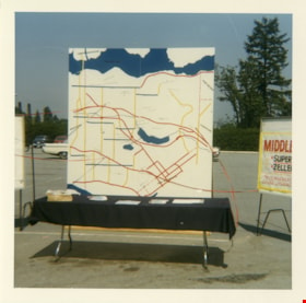
Map of Burnaby
https://search.heritageburnaby.ca/link/museumdescription13259
- Repository
- Burnaby Village Museum
- Date
- 1971
- Collection/Fonds
- Donald Copan collection
- Description Level
- Item
- Physical Description
- 1 photograph : col. ; 8.9 x 8.9 cm
- Scope and Content
- Photograph of a large map of Burnaby displayed on a table in a parking lot. A poster for "Middlegate" Shopping Centre is displayed to the right.
- Repository
- Burnaby Village Museum
- Collection/Fonds
- Donald Copan collection
- Series
- Copan album series
- Description Level
- Item
- Physical Description
- 1 photograph : col. ; 8.9 x 8.9 cm
- Scope and Content
- Photograph of a large map of Burnaby displayed on a table in a parking lot. A poster for "Middlegate" Shopping Centre is displayed to the right.
- Accession Code
- BV005.54.273
- Access Restriction
- No restrictions
- Reproduction Restriction
- May be restricted by third party rights
- Date
- 1971
- Media Type
- Photograph
- Scan Resolution
- 600
- Scan Date
- July 23, 2020
- Scale
- 100
- Notes
- Title based on contents of photograph
Images


Middlegate
https://search.heritageburnaby.ca/link/archivedescription79965
- Repository
- City of Burnaby Archives
- Date
- October 20, 1976
- Collection/Fonds
- Burnaby Public Library Contemporary Visual Archive Project
- Description Level
- Item
- Physical Description
- 1 photograph : b&w ; 11 x 16 cm mounted on cardboard
- Scope and Content
- Photograph shows a view of Kingsway near the Middlegate Shopping Centre, looking northwest from Hall Towers.
- Repository
- City of Burnaby Archives
- Date
- October 20, 1976
- Collection/Fonds
- Burnaby Public Library Contemporary Visual Archive Project
- Physical Description
- 1 photograph : b&w ; 11 x 16 cm mounted on cardboard
- Description Level
- Item
- Record No.
- 556-528
- Access Restriction
- No restrictions
- Reproduction Restriction
- Reproduce for fair dealing purposes only
- Accession Number
- 2013-13
- Scope and Content
- Photograph shows a view of Kingsway near the Middlegate Shopping Centre, looking northwest from Hall Towers.
- Subjects
- Aerial Photographs
- Media Type
- Photograph
- Photographer
- Ross, Martha
- Notes
- Scope note taken directly from BPL photograph description.
- 1 b&w copy negative : 10 x 12.5 cm accompanying
- Geographic Access
- Kingsway
- Historic Neighbourhood
- Edmonds (Historic Neighbourhood)
- Planning Study Area
- Stride Avenue Area
Images

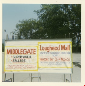
Posters for Middlegate shopping centre and Lougheed mall
https://search.heritageburnaby.ca/link/museumdescription13260
- Repository
- Burnaby Village Museum
- Date
- 1971
- Collection/Fonds
- Donald Copan collection
- Description Level
- Item
- Physical Description
- 1 photograph : col. ; 8.9 x 8.9 cm
- Scope and Content
- Photograph of posters for Middlegate Shopping Centre and Lougheed Mall on display in a parking lot.
- Repository
- Burnaby Village Museum
- Collection/Fonds
- Donald Copan collection
- Series
- Copan album series
- Description Level
- Item
- Physical Description
- 1 photograph : col. ; 8.9 x 8.9 cm
- Scope and Content
- Photograph of posters for Middlegate Shopping Centre and Lougheed Mall on display in a parking lot.
- Accession Code
- BV005.54.274
- Access Restriction
- No restrictions
- Reproduction Restriction
- May be restricted by third party rights
- Date
- 1971
- Media Type
- Photograph
- Scan Resolution
- 600
- Scan Date
- July 23, 2020
- Scale
- 100
- Notes
- Title based on contents of photograph
Images


Road Construction
https://search.heritageburnaby.ca/link/archivedescription79978
- Repository
- City of Burnaby Archives
- Date
- September 20, 1976
- Collection/Fonds
- Burnaby Public Library Contemporary Visual Archive Project
- Description Level
- Item
- Physical Description
- 1 photograph : b&w ; 11 x 16 cm mounted on cardboard
- Scope and Content
- Photograph shows view of road construction on Broadway behind the Lake City Industrial Park.
- Repository
- City of Burnaby Archives
- Date
- September 20, 1976
- Collection/Fonds
- Burnaby Public Library Contemporary Visual Archive Project
- Physical Description
- 1 photograph : b&w ; 11 x 16 cm mounted on cardboard
- Description Level
- Item
- Record No.
- 556-534
- Access Restriction
- No restrictions
- Reproduction Restriction
- Reproduce for fair dealing purposes only
- Accession Number
- 2013-13
- Scope and Content
- Photograph shows view of road construction on Broadway behind the Lake City Industrial Park.
- Media Type
- Photograph
- Photographer
- Campbell, Peg
- Notes
- Scope note taken directly from BPL photograph description.
- 1 b&w copy negative : 10 x 12.5 cm accompanying
- Geographic Access
- Broadway
- Planning Study Area
- Lake City Area
Images

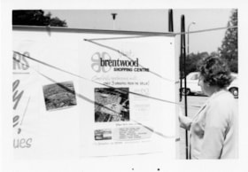
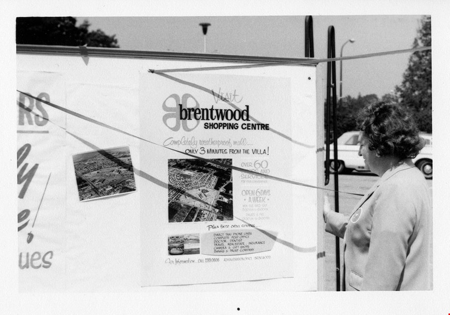
Rose Bancroft with Brentwood Shopping Centre poster
https://search.heritageburnaby.ca/link/museumdescription13254
- Repository
- Burnaby Village Museum
- Date
- 1971
- Collection/Fonds
- Donald Copan collection
- Description Level
- Item
- Physical Description
- 1 photograph : b&w ; 8.9 x 12.7 cm
- Scope and Content
- Photograph of Photograph of Burnaby Centennial '71 vice chair Rose Bancroft with Brentwood Shopping Centre poster.
- Repository
- Burnaby Village Museum
- Collection/Fonds
- Donald Copan collection
- Series
- Copan album series
- Description Level
- Item
- Physical Description
- 1 photograph : b&w ; 8.9 x 12.7 cm
- Scope and Content
- Photograph of Photograph of Burnaby Centennial '71 vice chair Rose Bancroft with Brentwood Shopping Centre poster.
- Names
- Bancroft, Rose
- Accession Code
- BV005.54.268
- Access Restriction
- No restrictions
- Reproduction Restriction
- May be restricted by third party rights
- Date
- 1971
- Media Type
- Photograph
- Scan Resolution
- 600
- Scan Date
- July 23, 2020
- Scale
- 100
- Notes
- Title based on contents of photograph
Images


Rose Bancroft with Brentwood Shopping Centre poster
https://search.heritageburnaby.ca/link/museumdescription13257
- Repository
- Burnaby Village Museum
- Date
- 1971
- Collection/Fonds
- Donald Copan collection
- Description Level
- Item
- Physical Description
- 1 photograph : b&w ; 8.9 x 12.7 cm
- Scope and Content
- Photograph of Photograph of Burnaby Centennial '71 vice chair Rose Bancroft with Brentwood Shopping Centre poster.
- Repository
- Burnaby Village Museum
- Collection/Fonds
- Donald Copan collection
- Series
- Copan album series
- Description Level
- Item
- Physical Description
- 1 photograph : b&w ; 8.9 x 12.7 cm
- Scope and Content
- Photograph of Photograph of Burnaby Centennial '71 vice chair Rose Bancroft with Brentwood Shopping Centre poster.
- Accession Code
- BV005.54.271
- Access Restriction
- No restrictions
- Reproduction Restriction
- May be restricted by third party rights
- Date
- 1971
- Media Type
- Photograph
- Scan Resolution
- 600
- Scan Date
- July 23, 2020
- Scale
- 100
- Notes
- Title based on contents of photograph
Images
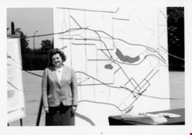
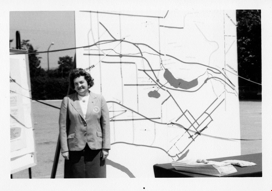
Rose Bancroft with Burnaby map
https://search.heritageburnaby.ca/link/museumdescription13256
- Repository
- Burnaby Village Museum
- Date
- 1971
- Collection/Fonds
- Donald Copan collection
- Description Level
- Item
- Physical Description
- 1 photograph : b&w ; 8.9 x 12.7 cm
- Scope and Content
- Photograph of Burnaby Centennial '71 vice chair Rose Bancroft standing in front of a large map of Burnaby.
- Repository
- Burnaby Village Museum
- Collection/Fonds
- Donald Copan collection
- Series
- Copan album series
- Description Level
- Item
- Physical Description
- 1 photograph : b&w ; 8.9 x 12.7 cm
- Scope and Content
- Photograph of Burnaby Centennial '71 vice chair Rose Bancroft standing in front of a large map of Burnaby.
- Names
- Bancroft, Rose
- Accession Code
- BV005.54.270
- Access Restriction
- No restrictions
- Reproduction Restriction
- May be restricted by third party rights
- Date
- 1971
- Media Type
- Photograph
- Scan Resolution
- 600
- Scan Date
- July 23, 2020
- Scale
- 100
- Notes
- Title based on contents of photograph
Images