Narrow Results By
Subject
- Advertising Medium - Signs and Signboards 1
- Buildings - Civic - Museums 1
- Buildings - Heritage 1
- Buildings - Religious 2
- Buildings - Religious - Churches 46
- Buildings - Residential - Houses 1
- Buildings - Schools 1
- Documentary Artifacts - Postcards 3
- Events - Royal Visits 1
- Geographic Features - Roads 3
- Plants - Flowers 1
Person / Organization
- All Saints Anglican Church 1
- Burnaby North Baptist Church 1
- Burnaby Village Museum 2
- Capitol Hill Pentecostal Tabernacle 1
- Central Park Presbyterian Church 1
- Danish Evangelical Lutheran Church of Vancouver 1
- Dundonald United Church 2
- Ellesmere United Church 1
- First United Spiritualist Church 1
- Gizeh Shrine Temple 1
- Henrik, Prince, consort of Margarethe II, Queen of Denmark, 1934- 1
- Italian Pentecostal Church 2
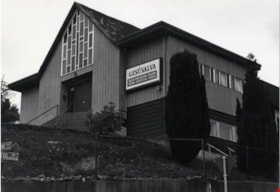
![3900 Albert Street, [between 1965 and 1970] thumbnail](/media/hpo/_Data/_Archives_Images/_Unrestricted/316/366-018.jpg?width=280)
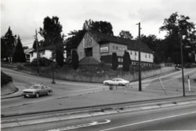
3900 Albert Street
https://search.heritageburnaby.ca/link/archivedescription37389
- Repository
- City of Burnaby Archives
- Date
- [between 1965 and 1970]
- Collection/Fonds
- Burnaby Historical Society fonds
- Description Level
- Item
- Physical Description
- 1 photograph : b&w negative
- Scope and Content
- Photograph of the north side of 3900 Albert Street, looking west. The Vancouver Heights Baptist Church can be seen to the far right (at the corner of Albert Street and Ingleton Avenue).
- Repository
- City of Burnaby Archives
- Date
- [between 1965 and 1970]
- Collection/Fonds
- Burnaby Historical Society fonds
- Subseries
- Municipal record subseries
- Physical Description
- 1 photograph : b&w negative
- Description Level
- Item
- Record No.
- 366-018
- Access Restriction
- No restrictions
- Reproduction Restriction
- Reproduce for fair dealing purposes only
- Accession Number
- BHS1998-12
- Scope and Content
- Photograph of the north side of 3900 Albert Street, looking west. The Vancouver Heights Baptist Church can be seen to the far right (at the corner of Albert Street and Ingleton Avenue).
- Media Type
- Photograph
- Notes
- Title based on contents of photograph
- Geographic Access
- Ingleton Avenue
- Albert Street
- Street Address
- 3900 Albert Street
- 271 Ingleton Avenue
- 3977 Albert Street
- Historic Neighbourhood
- Vancouver Heights (Historic Neighbourhood)
- Planning Study Area
- Burnaby Heights Area
Images
![3900 Albert Street, [between 1965 and 1970] thumbnail](/media/hpo/_Data/_Archives_Images/_Unrestricted/316/366-018.jpg)
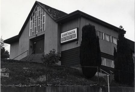
![3900 Albert Street at Ingleton Avenue, [between 1965 and 1970] thumbnail](/media/hpo/_Data/_Archives_Images/_Unrestricted/316/366-019.jpg?width=280)
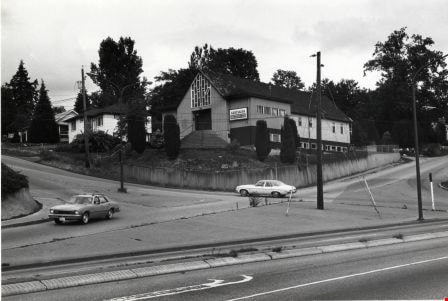
3900 Albert Street at Ingleton Avenue
https://search.heritageburnaby.ca/link/archivedescription37390
- Repository
- City of Burnaby Archives
- Date
- [between 1965 and 1970]
- Collection/Fonds
- Burnaby Historical Society fonds
- Description Level
- Item
- Physical Description
- 1 photograph : b&w negative
- Scope and Content
- Photograph looking west along the north side of Albert Street from the 3900 Block. At the far right can be seen the Vancouver Heights Baptist Church, at the intersection of Albert and Ingleton Avenue.
- Repository
- City of Burnaby Archives
- Date
- [between 1965 and 1970]
- Collection/Fonds
- Burnaby Historical Society fonds
- Subseries
- Municipal record subseries
- Physical Description
- 1 photograph : b&w negative
- Description Level
- Item
- Record No.
- 366-019
- Access Restriction
- No restrictions
- Reproduction Restriction
- Reproduce for fair dealing purposes only
- Accession Number
- BHS1998-12
- Scope and Content
- Photograph looking west along the north side of Albert Street from the 3900 Block. At the far right can be seen the Vancouver Heights Baptist Church, at the intersection of Albert and Ingleton Avenue.
- Media Type
- Photograph
- Notes
- Title based on contents of photograph.
- Geographic Access
- Albert Street
- Ingleton Avenue
- Street Address
- 3900 Albert Street
- 271 Ingleton Avenue
- Historic Neighbourhood
- Vancouver Heights (Historic Neighbourhood)
- Planning Study Area
- Burnaby Heights Area
Images
![3900 Albert Street at Ingleton Avenue, [between 1965 and 1970] thumbnail](/media/hpo/_Data/_Archives_Images/_Unrestricted/316/366-019.jpg)
5190 Norfolk St
https://search.heritageburnaby.ca/link/archivedescription93756
- Repository
- City of Burnaby Archives
- Date
- April 14, 1992
- Collection/Fonds
- Grover, Elliott & Co. Ltd. fonds
- Description Level
- File
- Physical Description
- 25 photographs : col. negatives ; 35 mm
- Scope and Content
- Photographs of the exterior of the Royal Oak Baptist Church located at 5190 Norfolk Street.
- Repository
- City of Burnaby Archives
- Date
- April 14, 1992
- Collection/Fonds
- Grover, Elliott & Co. Ltd. fonds
- Physical Description
- 25 photographs : col. negatives ; 35 mm
- Description Level
- File
- Record No.
- 622-041
- Access Restriction
- No restrictions
- Reproduction Restriction
- No restrictions
- Accession Number
- 2017-39
- Scope and Content
- Photographs of the exterior of the Royal Oak Baptist Church located at 5190 Norfolk Street.
- Subjects
- Buildings - Religious - Churches
- Media Type
- Photograph
- Photographer
- Young, Richard
- Notes
- Transcribed title
- Title transcribed from envelope photographs were originally housed in
- File no. 92-167-B
- Geographic Access
- Norfolk Street
- Street Address
- 5190 Norfolk Street
- Planning Study Area
- Douglas-Gilpin Area
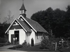
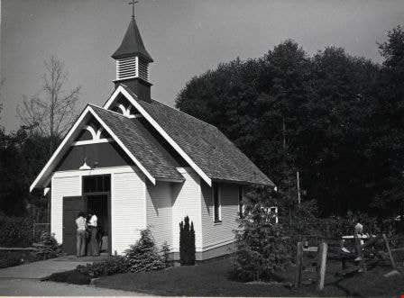
![All Saints Anglican Church and Parish Hall, [191-] thumbnail](/media/hpo/_Data/_BVM_Images/1977/198000120004.jpg?width=280)
All Saints Anglican Church and Parish Hall
https://search.heritageburnaby.ca/link/museumdescription3032
- Repository
- Burnaby Village Museum
- Date
- [191-]
- Collection/Fonds
- Burnaby Village Museum Photograph collection
- Description Level
- Item
- Physical Description
- 1 photograph : b&w postcard ; 8.8 x 13.9 cm
- Scope and Content
- Photographic postcard of two buildings identified as All Saints Anglican Church and Parish Hall. There are two men in work clothes (cover-alls) standing in between the two buildings. There is a ladder going up to the roof of one building.
- Repository
- Burnaby Village Museum
- Collection/Fonds
- Burnaby Village Museum Photograph collection
- Description Level
- Item
- Physical Description
- 1 photograph : b&w postcard ; 8.8 x 13.9 cm
- Scope and Content
- Photographic postcard of two buildings identified as All Saints Anglican Church and Parish Hall. There are two men in work clothes (cover-alls) standing in between the two buildings. There is a ladder going up to the roof of one building.
- Geographic Access
- Royal Oak Avenue
- Street Address
- 7405 Royal Oak Avenue
- Accession Code
- HV980.12.4
- Access Restriction
- No restrictions
- Reproduction Restriction
- May be restricted by third party rights
- Date
- [191-]
- Media Type
- Photograph
- Historic Neighbourhood
- Alta-Vista (Historic Neighbourhood)
- Planning Study Area
- Sussex-Nelson Area
- Scan Resolution
- 600
- Scan Date
- 2023-09-12
- Notes
- Title based on contents of photograph
Images
![All Saints Anglican Church and Parish Hall, [191-] thumbnail](/media/hpo/_Data/_BVM_Images/1977/198000120004.jpg)

Armstrong Avenue Baptist Church
https://search.heritageburnaby.ca/link/archivedescription79054
- Repository
- City of Burnaby Archives
- Date
- October, 1976
- Collection/Fonds
- Burnaby Public Library Contemporary Visual Archive Project
- Description Level
- Item
- Physical Description
- 1 photograph : b&w ; 11 x 16 cm mounted on cardboard
- Scope and Content
- Photograph shows the Armstrong Avenue Baptist Church at 8585 Armstrong Avenue. At the time of the photograph it was also the Korean Baptist Church.
- Repository
- City of Burnaby Archives
- Date
- October, 1976
- Collection/Fonds
- Burnaby Public Library Contemporary Visual Archive Project
- Physical Description
- 1 photograph : b&w ; 11 x 16 cm mounted on cardboard
- Description Level
- Item
- Record No.
- 556-120
- Access Restriction
- No restrictions
- Reproduction Restriction
- Reproduce for fair dealing purposes only
- Accession Number
- 2013-13
- Scope and Content
- Photograph shows the Armstrong Avenue Baptist Church at 8585 Armstrong Avenue. At the time of the photograph it was also the Korean Baptist Church.
- Subjects
- Buildings - Religious - Churches
- Names
- Korean Baptist Church
- Media Type
- Photograph
- Photographer
- Salmon, Stu
- Notes
- Scope note taken directly from BPL photograph description.
- 1 b&w copy negative : 10 x 12.5 cm accompanying
- Geographic Access
- Armstrong Avenue
- Street Address
- 8585 Armstrong Avenue
- Historic Neighbourhood
- East Burnaby (Historic Neighbourhood)
- Planning Study Area
- Cariboo-Armstrong Area
Images


Burnaby North Baptist Church
https://search.heritageburnaby.ca/link/archivedescription79055
- Repository
- City of Burnaby Archives
- Date
- September 12, 1976
- Collection/Fonds
- Burnaby Public Library Contemporary Visual Archive Project
- Description Level
- Item
- Physical Description
- 1 photograph : b&w ; 11 x 16 cm mounted on cardboard
- Scope and Content
- Photograph shows the Burnaby North Baptist Church at 3977 Albert Street on the corner of MacDonald Avenue.
- Repository
- City of Burnaby Archives
- Date
- September 12, 1976
- Collection/Fonds
- Burnaby Public Library Contemporary Visual Archive Project
- Physical Description
- 1 photograph : b&w ; 11 x 16 cm mounted on cardboard
- Description Level
- Item
- Record No.
- 556-121
- Access Restriction
- No restrictions
- Reproduction Restriction
- Reproduce for fair dealing purposes only
- Accession Number
- 2013-13
- Scope and Content
- Photograph shows the Burnaby North Baptist Church at 3977 Albert Street on the corner of MacDonald Avenue.
- Subjects
- Buildings - Religious - Churches
- Media Type
- Photograph
- Notes
- Scope note taken directly from BPL photograph description.
- 1 b&w copy negative : 10 x 12.5 cm accompanying
- Photographers identified by surnames only: Carr and Vardeman
- Geographic Access
- Albert Street
- Street Address
- 3977 Albert Street
- Historic Neighbourhood
- Vancouver Heights (Historic Neighbourhood)
- Planning Study Area
- Burnaby Heights Area
Images


Capitol Hill Pentecostal Tabernacle
https://search.heritageburnaby.ca/link/archivedescription79065
- Repository
- City of Burnaby Archives
- Date
- October 16, 1976
- Collection/Fonds
- Burnaby Public Library Contemporary Visual Archive Project
- Description Level
- Item
- Physical Description
- 1 photograph : b&w ; 11 x 16 cm mounted on cardboard
- Scope and Content
- Photograph shows the Capitol Hill Pentecostal Tabernacle located on the corner of Hastings Street and Springer Avenue, with apartment buildings in the background.
- Repository
- City of Burnaby Archives
- Date
- October 16, 1976
- Collection/Fonds
- Burnaby Public Library Contemporary Visual Archive Project
- Physical Description
- 1 photograph : b&w ; 11 x 16 cm mounted on cardboard
- Description Level
- Item
- Record No.
- 556-128
- Access Restriction
- No restrictions
- Reproduction Restriction
- Reproduce for fair dealing purposes only
- Accession Number
- 2013-13
- Scope and Content
- Photograph shows the Capitol Hill Pentecostal Tabernacle located on the corner of Hastings Street and Springer Avenue, with apartment buildings in the background.
- Subjects
- Buildings - Religious - Churches
- Media Type
- Photograph
- Notes
- Scope note taken directly from BPL photograph description.
- 1 b&w copy negative : 10 x 12.5 cm accompanying
- Photographers identified by surnames only: Carr and Vardeman
- Geographic Access
- Hastings Street
- Street Address
- 5209 Hastings Street
- Historic Neighbourhood
- Capitol Hill (Historic Neighbourhood)
- Planning Study Area
- Capitol Hill Area
Images


Central Park Presbyterian Church
https://search.heritageburnaby.ca/link/archivedescription36672
- Repository
- City of Burnaby Archives
- Date
- 1912 (date of original), copied 1992
- Collection/Fonds
- Burnaby Historical Society fonds
- Description Level
- Item
- Physical Description
- 1 photograph : b&w ; 10.1 x 14.9 cm print
- Scope and Content
- Photograph of Central Park Presbyterian Church and the surrounding area. The church was located on Westminster Road (later Kingsway) across from Central Park.
- Repository
- City of Burnaby Archives
- Date
- 1912 (date of original), copied 1992
- Collection/Fonds
- Burnaby Historical Society fonds
- Subseries
- Burnaby Centennial Anthology subseries
- Physical Description
- 1 photograph : b&w ; 10.1 x 14.9 cm print
- Description Level
- Item
- Record No.
- 315-027
- Access Restriction
- No restrictions
- Reproduction Restriction
- No known restrictions
- Accession Number
- BHS1994-04
- Scope and Content
- Photograph of Central Park Presbyterian Church and the surrounding area. The church was located on Westminster Road (later Kingsway) across from Central Park.
- Media Type
- Photograph
- Geographic Access
- Westminster Avenue
- Kingsway
- Street Address
- 3777 Kingsway
- Historic Neighbourhood
- Central Park (Historic Neighbourhood)
- Planning Study Area
- Garden Village Area
Images

![Church building, [1910] thumbnail](/media/hpo/_Data/_BVM_Images/1973/1973_0110_0056_001.jpg?width=280)
Church building
https://search.heritageburnaby.ca/link/museumdescription1042
- Repository
- Burnaby Village Museum
- Date
- [1910]
- Collection/Fonds
- Burnaby Village Museum Photograph collection
- Description Level
- Item
- Physical Description
- 1 photograph : sepia
- Scope and Content
- Photograph of an unidentified church building. The inscription indicates that the building is in Los Gates, California.
- Repository
- Burnaby Village Museum
- Collection/Fonds
- Burnaby Village Museum Photograph collection
- Description Level
- Item
- Physical Description
- 1 photograph : sepia
- Material Details
- inscribed in pencil, verso, t. "Oha/ In Los Gates/ California"
- Scope and Content
- Photograph of an unidentified church building. The inscription indicates that the building is in Los Gates, California.
- Subjects
- Buildings - Religious - Churches
- Accession Code
- HV973.110.56
- Access Restriction
- No restrictions
- Reproduction Restriction
- No known restrictions
- Date
- [1910]
- Media Type
- Photograph
- Scan Resolution
- 600
- Scan Date
- 2023-05-30
- Notes
- Title based on contents of photograph
Images
![Church building, [1910] thumbnail](/media/hpo/_Data/_BVM_Images/1973/1973_0110_0056_001.jpg)
Danish Lutheran Church
https://search.heritageburnaby.ca/link/archivedescription36620
- Repository
- City of Burnaby Archives
- Date
- October 16, 1991
- Collection/Fonds
- Burnaby Historical Society fonds
- Description Level
- Item
- Physical Description
- 1 photograph : b&w ; 19 x 24 cm
- Scope and Content
- Photograph of Her Royal Highness Queen Margrethe II and Prince Henrik of Denmark attending services at the Danish Lutheran Church in Burnaby.
- Repository
- City of Burnaby Archives
- Date
- October 16, 1991
- Collection/Fonds
- Burnaby Historical Society fonds
- Subseries
- Gavel Historical Society subseries
- Physical Description
- 1 photograph : b&w ; 19 x 24 cm
- Description Level
- Item
- Record No.
- 311-002
- Access Restriction
- No restrictions
- Reproduction Restriction
- Reproduce for fair dealing purposes only
- Accession Number
- BHS1994-03
- Scope and Content
- Photograph of Her Royal Highness Queen Margrethe II and Prince Henrik of Denmark attending services at the Danish Lutheran Church in Burnaby.
- Names
- Danish Evangelical Lutheran Church of Vancouver
- Margrethe II Queen of Denmark, 1940-
- Henrik, Prince, consort of Margarethe II, Queen of Denmark, 1934-
- Media Type
- Photograph
- Photographer
- Harrison, Jim
- Notes
- Title based on contents of photograph
- Geographic Access
- Kincaid Street
- Street Address
- 6010 Kincaid Street
- Historic Neighbourhood
- Burnaby Lake (Historic Neighbourhood)
- Planning Study Area
- Douglas-Gilpin Area
Images

![Dundonald United Church, [between 1911 and 1919] thumbnail](/media/hpo/_Data/_Archives_Images/_Unrestricted/316/325-022.jpg?width=280)
Dundonald United Church
https://search.heritageburnaby.ca/link/archivedescription37150
- Repository
- City of Burnaby Archives
- Date
- [between 1911 and 1919]
- Collection/Fonds
- Burnaby Historical Society fonds
- Description Level
- Item
- Physical Description
- 1 photograph : b&w ; 8.5 x 12.5 cm print
- Scope and Content
- Photograph of Dundonald United Church, taken from the school grounds of Riverway East (later renamed Dundonald School).
- Repository
- City of Burnaby Archives
- Date
- [between 1911 and 1919]
- Collection/Fonds
- Burnaby Historical Society fonds
- Subseries
- Disney family subseries
- Physical Description
- 1 photograph : b&w ; 8.5 x 12.5 cm print
- Description Level
- Item
- Record No.
- 325-022
- Access Restriction
- No restrictions
- Reproduction Restriction
- No known restrictions
- Accession Number
- BHS1996-04
- Scope and Content
- Photograph of Dundonald United Church, taken from the school grounds of Riverway East (later renamed Dundonald School).
- Subjects
- Buildings - Religious - Churches
- Media Type
- Photograph
- Photographer
- Disney, John Harold "Jack"
- Notes
- Title based on contents of photograph
- Geographic Access
- Marine Drive
- Clinton Street
- Gilley Avenue
- Curragh Avenue
- Historic Neighbourhood
- Alta-Vista (Historic Neighbourhood)
- Planning Study Area
- Clinton-Glenwood Area
Images
![Dundonald United Church, [between 1911 and 1919] thumbnail](/media/hpo/_Data/_Archives_Images/_Unrestricted/316/325-022.jpg)

Ellesmere United Church
https://search.heritageburnaby.ca/link/archivedescription79058
- Repository
- City of Burnaby Archives
- Date
- September 11, 1976
- Collection/Fonds
- Burnaby Public Library Contemporary Visual Archive Project
- Description Level
- Item
- Physical Description
- 1 photograph : b&w ; 11 x 16 cm mounted on cardboard
- Scope and Content
- Photograph shows the Ellesmere United Church at 75 North Howard Avenue, with a sign advertising a thrift shop in the basement.
- Repository
- City of Burnaby Archives
- Date
- September 11, 1976
- Collection/Fonds
- Burnaby Public Library Contemporary Visual Archive Project
- Physical Description
- 1 photograph : b&w ; 11 x 16 cm mounted on cardboard
- Description Level
- Item
- Record No.
- 556-123
- Access Restriction
- No restrictions
- Reproduction Restriction
- Reproduce for fair dealing purposes only
- Accession Number
- 2013-13
- Scope and Content
- Photograph shows the Ellesmere United Church at 75 North Howard Avenue, with a sign advertising a thrift shop in the basement.
- Subjects
- Buildings - Religious - Churches
- Names
- Ellesmere United Church
- Media Type
- Photograph
- Notes
- Scope note taken directly from BPL photograph description.
- 1 b&w copy negative : 10 x 12.5 cm accompanying
- Photographers identified by surnames only: Carr and Vardeman
- Geographic Access
- Howard Avenue
- Street Address
- 75 Howard Avenue
- Historic Neighbourhood
- Capitol Hill (Historic Neighbourhood)
- Planning Study Area
- Capitol Hill Area
Images


First United Spiritualist Church
https://search.heritageburnaby.ca/link/archivedescription79041
- Repository
- City of Burnaby Archives
- Date
- October, 1976
- Collection/Fonds
- Burnaby Public Library Contemporary Visual Archive Project
- Description Level
- Item
- Physical Description
- 1 photograph : b&w ; 11 x 16 cm mounted on cardboard
- Scope and Content
- Photograph shows the First United Spiritualist Church located at 5584 Kincaid Street. This structure was originally built on the triangle across from Forest Lawn Cemetery at Royal Oak Avenue and Canada Way to serve as the funeral parlor for Forest Lawn. In 1955 it was moved to the Kincaid address…
- Repository
- City of Burnaby Archives
- Date
- October, 1976
- Collection/Fonds
- Burnaby Public Library Contemporary Visual Archive Project
- Physical Description
- 1 photograph : b&w ; 11 x 16 cm mounted on cardboard
- Description Level
- Item
- Record No.
- 556-109
- Access Restriction
- No restrictions
- Reproduction Restriction
- Reproduce for fair dealing purposes only
- Accession Number
- 2013-13
- Scope and Content
- Photograph shows the First United Spiritualist Church located at 5584 Kincaid Street. This structure was originally built on the triangle across from Forest Lawn Cemetery at Royal Oak Avenue and Canada Way to serve as the funeral parlor for Forest Lawn. In 1955 it was moved to the Kincaid address and occupied by the St. Columba Anglican Church which was vacated in December 1970. In April 1971, the First United Spiritualist Church moved in.
- Subjects
- Buildings - Religious - Churches
- Media Type
- Photograph
- Photographer
- Salmon, Stu
- Notes
- Scope note taken directly from BPL photograph description.
- 1 b&w copy negative : 10 x 12.5 cm accompanying
- Geographic Access
- Kincaid Street
- Street Address
- 5584 Kincaid Street
- Planning Study Area
- Douglas-Gilpin Area
Images

![Fort Augustus Abbey, [1900-1930] thumbnail](/media/hpo/_Data/_Archives_Images/_Unrestricted/550/550-145.jpg?width=280)
Fort Augustus Abbey
https://search.heritageburnaby.ca/link/archivedescription82575
- Repository
- City of Burnaby Archives
- Date
- [1900-1930]
- Collection/Fonds
- Hill family and Vidal family fonds
- Description Level
- Item
- Physical Description
- 1 photograph : sepia postcard ; 8.5 x 13.5 cm
- Scope and Content
- Photographic postcard shows a building situated by a body of water and mountains. The building is identified as Fort Augustus Abbey.
- Repository
- City of Burnaby Archives
- Date
- [1900-1930]
- Collection/Fonds
- Hill family and Vidal family fonds
- Physical Description
- 1 photograph : sepia postcard ; 8.5 x 13.5 cm
- Description Level
- Item
- Record No.
- 550-145
- Access Restriction
- No restrictions
- Reproduction Restriction
- No known restrictions
- Accession Number
- 2013-03
- Scope and Content
- Photographic postcard shows a building situated by a body of water and mountains. The building is identified as Fort Augustus Abbey.
- Subjects
- Buildings - Religious
- Media Type
- Photograph
- Notes
- Title based on contents of photograph
- Bottom of recto reads: "The Abbey, Fort Augustus"
- Note in black pen on verso reads: "9th September / We arrived here last night after a run through the Canal Loch Ness, & we ... by train to Frot William - Inverness is awfully pretty, & we had lovely weather - I should like to stay here for a week - it is so peaceful & beautiful views over the Loch. Love from K L M / Mrs J G Craig / 25 Harrington Gdus / London S W 7 / England"
- Postage stamps on verso reads: "Halfpenny"
Images
![Fort Augustus Abbey, [1900-1930] thumbnail](/media/hpo/_Data/_Archives_Images/_Unrestricted/550/550-145.jpg)
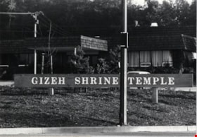
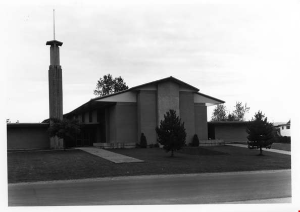
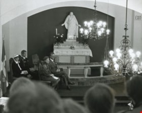
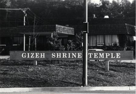
Gizeh Shrine Temple
https://search.heritageburnaby.ca/link/archivedescription79070
- Repository
- City of Burnaby Archives
- Date
- October, 1976
- Collection/Fonds
- Burnaby Public Library Contemporary Visual Archive Project
- Description Level
- Item
- Physical Description
- 1 photograph : b&w ; 11 x 16 cm mounted on cardboard
- Scope and Content
- Photograph shows the Gizeh Shrine Temple at 3550 Wayburne Drive, one block south of Canada Way. It was built in 1969.
- Repository
- City of Burnaby Archives
- Date
- October, 1976
- Collection/Fonds
- Burnaby Public Library Contemporary Visual Archive Project
- Physical Description
- 1 photograph : b&w ; 11 x 16 cm mounted on cardboard
- Description Level
- Item
- Record No.
- 556-132
- Access Restriction
- No restrictions
- Reproduction Restriction
- Reproduce for fair dealing purposes only
- Accession Number
- 2013-13
- Scope and Content
- Photograph shows the Gizeh Shrine Temple at 3550 Wayburne Drive, one block south of Canada Way. It was built in 1969.
- Subjects
- Buildings - Religious - Churches
- Names
- Gizeh Shrine Temple
- Media Type
- Photograph
- Photographer
- Salmon, Stu
- Notes
- Scope note taken directly from BPL photograph description.
- 1 b&w copy negative : 10 x 12.5 cm accompanying
- Geographic Access
- Wayburne Drive
- Street Address
- 3550 Wayburne Drive
- Planning Study Area
- Douglas-Gilpin Area
Images
Heritage Village
https://search.heritageburnaby.ca/link/archivedescription79787
- Repository
- City of Burnaby Archives
- Date
- September, 1976
- Collection/Fonds
- Burnaby Public Library Contemporary Visual Archive Project
- Description Level
- Item
- Physical Description
- 1 photograph : b&w ; 11 x 16 cm mounted on cardboard
- Scope and Content
- Photograph shows the church at Heritage Village which is used for private ceremonies such as weddings and baptisms.
- Repository
- City of Burnaby Archives
- Date
- September, 1976
- Collection/Fonds
- Burnaby Public Library Contemporary Visual Archive Project
- Physical Description
- 1 photograph : b&w ; 11 x 16 cm mounted on cardboard
- Description Level
- Item
- Record No.
- 556-434
- Access Restriction
- No restrictions
- Reproduction Restriction
- Reproduce for fair dealing purposes only
- Accession Number
- 2013-13
- Scope and Content
- Photograph shows the church at Heritage Village which is used for private ceremonies such as weddings and baptisms.
- Names
- Burnaby Village Museum
- Media Type
- Photograph
- Photographer
- Salmon, Stu
- Notes
- Scope note taken directly from BPL photograph description.
- 1 b&w copy negative : 10 x 12.5 cm accompanying
- Geographic Access
- Deer Lake Avenue
- Street Address
- 6501 Deer Lake Avenue
- Historic Neighbourhood
- Burnaby Lake (Historic Neighbourhood)
- Planning Study Area
- Morley-Buckingham Area
Images
![Island Shore, [between 1908 and 1911] thumbnail](/media/hpo/_Data/_BVM_Images/1972/1972_0050_0015_001.jpg?width=280)
Island Shore
https://search.heritageburnaby.ca/link/museumdescription1076
- Repository
- Burnaby Village Museum
- Date
- [between 1908 and 1911]
- Collection/Fonds
- Burnaby Village Museum Photograph collection
- Description Level
- Item
- Physical Description
- 1 photograph : b&w ; 7.4 x 9.8 cm mounted on paper 13.6 x 18.3 cm
- Scope and Content
- Photograph of an unidentified shoreline as seen from the water. Houses and a church with a steeple are visible.
- Repository
- Burnaby Village Museum
- Collection/Fonds
- Burnaby Village Museum Photograph collection
- Description Level
- Item
- Physical Description
- 1 photograph : b&w ; 7.4 x 9.8 cm mounted on paper 13.6 x 18.3 cm
- Scope and Content
- Photograph of an unidentified shoreline as seen from the water. Houses and a church with a steeple are visible.
- Accession Code
- HV972.50.15
- Access Restriction
- No restrictions
- Reproduction Restriction
- No known restrictions
- Date
- [between 1908 and 1911]
- Media Type
- Photograph
- Scan Resolution
- 600
- Scan Date
- 2023-04-04
- Photographer
- Dean, H.M.
- Notes
- Title based on contents of photograph
Images
![Island Shore, [between 1908 and 1911] thumbnail](/media/hpo/_Data/_BVM_Images/1972/1972_0050_0015_001.jpg)
Italian Pentecostal Church
https://search.heritageburnaby.ca/link/archivedescription79062
- Repository
- City of Burnaby Archives
- Date
- October, 1976
- Collection/Fonds
- Burnaby Public Library Contemporary Visual Archive Project
- Description Level
- Item
- Physical Description
- 1 photograph : b&w ; 11 x 16 cm mounted on cardboard
- Scope and Content
- Photograph shows the Italian Pentecostal Church on the corner of Hythe Avenue and Capitol Drive with Hastings Street in the foreground.
- Repository
- City of Burnaby Archives
- Date
- October, 1976
- Collection/Fonds
- Burnaby Public Library Contemporary Visual Archive Project
- Physical Description
- 1 photograph : b&w ; 11 x 16 cm mounted on cardboard
- Description Level
- Item
- Record No.
- 556-126
- Access Restriction
- No restrictions
- Reproduction Restriction
- Reproduce for fair dealing purposes only
- Accession Number
- 2013-13
- Scope and Content
- Photograph shows the Italian Pentecostal Church on the corner of Hythe Avenue and Capitol Drive with Hastings Street in the foreground.
- Subjects
- Buildings - Religious - Churches
- Media Type
- Photograph
- Photographer
- Cook, Alan
- Notes
- Scope note taken directly from BPL photograph description.
- 1 b&w copy negative : 10 x 12.5 cm accompanying
- Geographic Access
- Capitol Drive
- Street Address
- 5100 Capitol Drive
- Historic Neighbourhood
- Capitol Hill (Historic Neighbourhood)
- Planning Study Area
- Capitol Hill Area
Images
Italian Pentecostal Church
https://search.heritageburnaby.ca/link/archivedescription79063
- Repository
- City of Burnaby Archives
- Date
- September 12, 1976
- Collection/Fonds
- Burnaby Public Library Contemporary Visual Archive Project
- Description Level
- Item
- Physical Description
- 1 photograph : b&w ; 11 x 16 cm mounted on cardboard
- Scope and Content
- Photograph shows the Italian Pentecostal Church on the corner of Hythe Avenue and Capitol Drive.
- Repository
- City of Burnaby Archives
- Date
- September 12, 1976
- Collection/Fonds
- Burnaby Public Library Contemporary Visual Archive Project
- Physical Description
- 1 photograph : b&w ; 11 x 16 cm mounted on cardboard
- Description Level
- Item
- Record No.
- 556-127
- Access Restriction
- No restrictions
- Reproduction Restriction
- Reproduce for fair dealing purposes only
- Accession Number
- 2013-13
- Scope and Content
- Photograph shows the Italian Pentecostal Church on the corner of Hythe Avenue and Capitol Drive.
- Subjects
- Buildings - Religious - Churches
- Media Type
- Photograph
- Notes
- Scope note taken directly from BPL photograph description.
- 1 b&w copy negative : 10 x 12.5 cm accompanying
- Photographers identified by surnames only: Carr and Vardeman
- Geographic Access
- Capitol Drive
- Street Address
- 5100 Capitol Drive
- Historic Neighbourhood
- Capitol Hill (Historic Neighbourhood)
- Planning Study Area
- Capitol Hill Area
Images
Mormon Church & Genealogical Library
https://search.heritageburnaby.ca/link/archivedescription93633
- Repository
- City of Burnaby Archives
- Date
- October 27, 1977
- Collection/Fonds
- Burnaby Public Library Contemporary Visual Archive Project
- Description Level
- Item
- Physical Description
- 1 photograph : b&w ; 12.5 x 17.5 cm
- Scope and Content
- Photograph of the exterior of The Church of Jesus Christ of Latter Day Saints and its Family History Centre, located at 5280 Kincaid Street. The photograph is taken from across the street, facing southwest.
- Repository
- City of Burnaby Archives
- Date
- October 27, 1977
- Collection/Fonds
- Burnaby Public Library Contemporary Visual Archive Project
- Physical Description
- 1 photograph : b&w ; 12.5 x 17.5 cm
- Description Level
- Item
- Record No.
- 556-590
- Access Restriction
- No restrictions
- Reproduction Restriction
- Reproduce for fair dealing purposes only
- Accession Number
- 2017-57
- Scope and Content
- Photograph of the exterior of The Church of Jesus Christ of Latter Day Saints and its Family History Centre, located at 5280 Kincaid Street. The photograph is taken from across the street, facing southwest.
- Subjects
- Buildings - Religious - Churches
- Media Type
- Photograph
- Photographer
- Surridge, Jack
- Notes
- Title taken from project information form
- Accompanied by a project information form and 1 photograph (b&w negative ; 9.5 x 12.5 cm)
- BPL no. 39
- Geographic Access
- Kincaid Street
- Street Address
- 5280 Kincaid Street
- Historic Neighbourhood
- Burnaby Lake (Historic Neighbourhood)
- Planning Study Area
- Douglas-Gilpin Area
Images