Narrow Results By
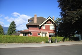
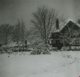
Robert & Mary B. McLennan House
https://search.heritageburnaby.ca/link/landmark634
- Repository
- Burnaby Heritage Planning
- Description
- Residential building.
- Associated Dates
- 1911
- Street View URL
- Google Maps Street View
- Repository
- Burnaby Heritage Planning
- Geographic Access
- Yale Street
- Associated Dates
- 1911
- Description
- Residential building.
- Heritage Value
- Robert McLennan was the vice-president of the prominent Vancouver hardware firm of McLennan, McFeely & Company, popularly known as Mc.& Mc. Born in Pictou, Nova Scotia in 1861, Robert McLennan entered the hardware business at age fifteen. The West was an irresistible lure, and after he moved to Victoria in 1884, he took on a friend, Edward J. McFeely, as a business partner. Their business was a success and they soon opened a branch in the rapidly-developing new city of Vancouver. In 1898, Robert went to Dawson, where he opened a branch operation and served as mayor for one year in 1903. He returned to Vancouver in 1904, and as the business expanded, E.G. Prior was taken on as partner. In addition to his business pursuits, the public-spirited McLennan served on many boards and committees. In 1887, Robert returned to Nova Scotia where he married Bessie Archibald McKenzie. They had nine children, one of whom was born in Dawson. Robert died in 1927, and Bessie died in 1941. This grand residence was one of the first to be built in the Vancouver Heights subdivision, and its spectacular location retains panoramic views of Burrard Inlet and the North Shore. This house was undoubtedly designed by a local architect as it is an excellent example of the British Arts and Crafts style, with a shingled exterior, half-timbered gables and prominent brick chimneys. Although the west verandah has been enclosed and the windows altered, the house has been well maintained. Although owned by the McLennans, it may have been an investment property, as they lived for many years at a Vancouver address. In 1926, the house was sold to Vancouver Medical Health Officer, F.T. Underhill.
- Locality
- Vancouver Heights
- Historic Neighbourhood
- Vancouver Heights (Historic Neighbourhood)
- Planning Study Area
- Burnaby Heights Area
- Area
- 576.00
- Contributing Resource
- Building
- Ownership
- Private
- Street Address
- 3789 Yale Street
- Street View URL
- Google Maps Street View
Images
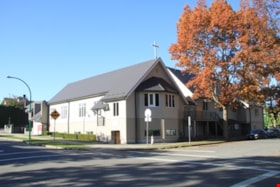
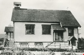
St. Nicholas Anglican Church
https://search.heritageburnaby.ca/link/landmark641
- Repository
- Burnaby Heritage Planning
- Description
- Church building.
- Associated Dates
- 1912
- Street View URL
- Google Maps Street View
- Repository
- Burnaby Heritage Planning
- Geographic Access
- Triumph Street
- Associated Dates
- 1912
- Description
- Church building.
- Heritage Value
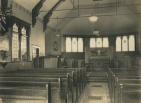
- This church was one of the first built in North Burnaby to serve the new community of Vancouver Heights. Designed by architect Frank Barrs and constructed by local builders, Arthur England and Mr. Scott, it reflected the English roots of the Anglican Church with its fine Arts and Crafts style. It was officially opened in an impressive ceremony by the Bishop of New Westminster and could accommodate 200 worshippers. It was named after Saint Nicholas, the patron saint of sailors. The adjoining parish hall was completed in 1920. The church building features a gabled roof, triangular eave brackets and a semi-octagonal apse. Stucco has been applied to the exterior, but it retains its original form, scale and massing. It now houses the Burnaby Pacific Grace Church. English-born Frank Barrs (1871-1963) arrived in Vancouver in 1907 and established an office for about one year before he began working for the Vancouver Exhibition Association. He briefly established a partnership (1912-1913) with Samuel Shewbrooks (1877-1957), and was active as an architect until about 1933.
- Locality
- Vancouver Heights
- Historic Neighbourhood
- Vancouver Heights (Historic Neighbourhood)
- Planning Study Area
- Burnaby Heights Area
- Architect
- Frank A.A. Barrs
- Area
- 1695.45
- Contributing Resource
- Building
- Ownership
- Private
- Street Address
- 3883 Triumph Street
- Street View URL
- Google Maps Street View
Images
Vancouver Heights Neighbourhood
https://search.heritageburnaby.ca/link/landmark741
- Repository
- Burnaby Heritage Planning
- Associated Dates
- 1905-1924
- Heritage Value
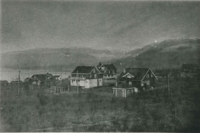
- On December 13, 1912, The British Columbian Weekly described the Vancouver Heights neighbourhood as follows: "The northern portion of the municipality in the vicinity of Boundary Road has during the past three years made tremendous strides towards settlement. At that time Mr. James Herd and Mr. Peters were the only residents of the district...Soon, however, the timber was removed, streets laid out and other conveniences such as water, light and transportation provided... The school population of the district has increased so rapidly that the school has been enlarged twice this year and is at the present time inadequate. About 200 children are attending now. There are three churches in the district and one mission...At present time there are two large blocks containing six stores..."
- Historic Neighbourhood
- Vancouver Heights (Historic Neighbourhood)
- Planning Study Area
- Burnaby Heights Area
Images
Wall Block
https://search.heritageburnaby.ca/link/landmark651
- Repository
- Burnaby Heritage Planning
- Description
- Commercial building.
- Associated Dates
- 1912
- Street View URL
- Google Maps Street View
- Repository
- Burnaby Heritage Planning
- Geographic Access
- Hastings Street
- Associated Dates
- 1912
- Description
- Commercial building.
- Heritage Value
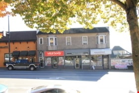
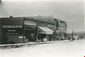
- One of the prominent buildings along Vancouver Height’s early commercial strip, this block has continuously served its original commercial/retail use, with apartments on the second floor. Alterations over the years have included a coat of stucco over the original lapped wooden siding, and the alteration of the roofline cornice. Notably, the building has retained its distinctive second storey bay windows and three ground floor commercial spaces with recessed entrances. It was financed and built by Arthur Wall, a director of Hill, Wall & Company Ltd. Real Estate, which was based in the Pacific Block in Vancouver.
- Locality
- Vancouver Heights
- Historic Neighbourhood
- Vancouver Heights (Historic Neighbourhood)
- Planning Study Area
- Willingdon Heights Area
- Area
- 473.81
- Contributing Resource
- Building
- Ownership
- Private
- Street Address
- 3722 Hastings Street
- Street View URL
- Google Maps Street View
