More like 'Bill Copeland Sports Centre'
Narrow Results By
Decade
- 2020s 98
- 2010s 70
- 2000s 503
- 1990s 602
- 1980s 465
- 1970s 794
- 1960s
- 1950s 524
- 1940s 476
- 1930s 437
- 1920s 522
- 1910s
- 1900s 205
- 1890s 27
- 1880s 50
- 1870s 4
- 1860s 2
- 1850s 1
- 1840s 1
- 1830s 1
- 1820s 1
- 1810s 1
- 1800s 1
- 1790s 1
- 1780s 1
- 1770s 1
- 1760s 1
- 1750s 1
- 1740s 1
- 1730s 1
- 1720s 1
- 1710s 1
- 1700s 1
- 1690s 1
- 1680s 1
- 1670s 1
- 1660s 1
- 1650s 1
- 1640s 1
- 1630s 1
- 1620s 1
- 1610s 1
- 1600s 1
Creator
- Barrowclough, G.A. 1
- Battistoni, Peter 2
- BC Photo Card Company 1
- Bellinger, Bernard 2
- Binks, James 2
- Brown, Shirley 2
- Burnaby Village Museum 19
- Burnett and McGugan B.C. Land Surveyors, New Westminster 5
- Burnett, Geoffrey K. 3
- Burnett & McGugan, Engineers and Surveyors 22
- Canadian Photo Company 12
- Challoner-Courtenay, E.J. 2
![D.C. Patterson house, [1915] (date of original), copied 1986 thumbnail](/media/hpo/_Data/_Archives_Images/_Unrestricted/126/171-013.jpg?width=280)
D.C. Patterson house
https://search.heritageburnaby.ca/link/archivedescription34992
- Repository
- City of Burnaby Archives
- Date
- [1915] (date of original), copied 1986
- Collection/Fonds
- Burnaby Historical Society fonds
- Description Level
- Item
- Physical Description
- 1 photograph : b&w ; 8.8 x 12.5 cm print
- Scope and Content
- Photograph of the exterior of the home of Dugald C. Patterson, Sr., and his family. People are standing outside, and a man, possibly D.C. Patterson, is seated at the top of the stairs. The summer gazebo can be seen on the left of the photograph, and there is laundry on a line at the bottom right. …
- Repository
- City of Burnaby Archives
- Date
- [1915] (date of original), copied 1986
- Collection/Fonds
- Burnaby Historical Society fonds
- Subseries
- Patterson family subseries
- Physical Description
- 1 photograph : b&w ; 8.8 x 12.5 cm print
- Description Level
- Item
- Record No.
- 171-013
- Access Restriction
- No restrictions
- Reproduction Restriction
- No known restrictions
- Accession Number
- BHS1986-20
- Scope and Content
- Photograph of the exterior of the home of Dugald C. Patterson, Sr., and his family. People are standing outside, and a man, possibly D.C. Patterson, is seated at the top of the stairs. The summer gazebo can be seen on the left of the photograph, and there is laundry on a line at the bottom right. The Patterson family house was originally located at 7260 Edmonds Street (near Kingsway). It was relocated in 1955 to 7106 18th Avenue and is a city heritage site.
- Media Type
- Photograph
- Notes
- Title based on contents of photograph
- Geographic Access
- Edmonds Street
- 18th Avenue
- Street Address
- 7260 Edmonds Street
- 7106 18th Avenue
- Historic Neighbourhood
- Edmonds (Historic Neighbourhood)
- Planning Study Area
- Stride Avenue Area
Images
![D.C. Patterson house, [1915] (date of original), copied 1986 thumbnail](/media/hpo/_Data/_Archives_Images/_Unrestricted/126/171-013.jpg)
![Fairacres Gazebo and Mansion, [1914] thumbnail](/media/hpo/_Data/_Archives_Images/_Unrestricted/205/241-024.jpg?width=280)
Fairacres Gazebo and Mansion
https://search.heritageburnaby.ca/link/archivedescription36246
- Repository
- City of Burnaby Archives
- Date
- [1914]
- Collection/Fonds
- Burnaby Historical Society fonds
- Description Level
- Item
- Physical Description
- 1 photograph : b&w copy negative ; 7 x 10.5 cm
- Scope and Content
- Photograph of the Fairacres Gazebo and Mansion covered in snow.
- Repository
- City of Burnaby Archives
- Date
- [1914]
- Collection/Fonds
- Burnaby Historical Society fonds
- Subseries
- Burnaby Art Gallery subseries
- Physical Description
- 1 photograph : b&w copy negative ; 7 x 10.5 cm
- Description Level
- Item
- Record No.
- 241-024
- Access Restriction
- No restrictions
- Reproduction Restriction
- No known restrictions
- Accession Number
- BHS1990-05
- Scope and Content
- Photograph of the Fairacres Gazebo and Mansion covered in snow.
- Media Type
- Photograph
- Notes
- Title based on contents of photograph 1 b&w copy print accompanying
- Geographic Access
- Deer Lake Avenue
- Street Address
- 6344 Deer Lake Avenue
- Historic Neighbourhood
- Burnaby Lake (Historic Neighbourhood)
- Planning Study Area
- Douglas-Gilpin Area
Images
![Fairacres Gazebo and Mansion, [1914] thumbnail](/media/hpo/_Data/_Archives_Images/_Unrestricted/205/241-024.jpg)
![Bandsand in Stanley Park, Vancouver, BC, [between 1908 and 1911] thumbnail](/media/hpo/_Data/_BVM_Images/1972/1972_0050_0010_001.jpg?width=280)
Bandsand in Stanley Park, Vancouver, BC
https://search.heritageburnaby.ca/link/museumdescription1071
- Repository
- Burnaby Village Museum
- Date
- [between 1908 and 1911]
- Collection/Fonds
- Burnaby Village Museum Photograph collection
- Description Level
- Item
- Physical Description
- 1 photograph : sepia ; 7.3 x 9.9 cm
- Scope and Content
- Photograph of people walking towards the bandstand in Stanley Park, Vancouver. In 1934, the Malkin Bowl was erected at the site where the banstand used to be. An annotation on the back of the photograph reads, "Band stand in Stanley Park where Malkin Bowl now stands."
- Repository
- Burnaby Village Museum
- Collection/Fonds
- Burnaby Village Museum Photograph collection
- Description Level
- Item
- Physical Description
- 1 photograph : sepia ; 7.3 x 9.9 cm
- Scope and Content
- Photograph of people walking towards the bandstand in Stanley Park, Vancouver. In 1934, the Malkin Bowl was erected at the site where the banstand used to be. An annotation on the back of the photograph reads, "Band stand in Stanley Park where Malkin Bowl now stands."
- Geographic Access
- Vancouver
- Accession Code
- HV972.50.10
- Access Restriction
- No restrictions
- Reproduction Restriction
- No known restrictions
- Date
- [between 1908 and 1911]
- Media Type
- Photograph
- Scan Resolution
- 600
- Scan Date
- 2023-04-04
- Photographer
- Dean, H.M.
- Notes
- Title based on contents of photograph
Images
![Bandsand in Stanley Park, Vancouver, BC, [between 1908 and 1911] thumbnail](/media/hpo/_Data/_BVM_Images/1972/1972_0050_0010_001.jpg)
![Burnaby Mountain's Centennial Pavilion, [between 1960 and 1979] thumbnail](/media/hpo/_Data/_Archives_Images/_Unrestricted/205/222-026.jpg?width=280)
Burnaby Mountain's Centennial Pavilion
https://search.heritageburnaby.ca/link/archivedescription36103
- Repository
- City of Burnaby Archives
- Date
- [between 1960 and 1979]
- Collection/Fonds
- Burnaby Historical Society fonds
- Description Level
- Item
- Physical Description
- 1 photograph : b&w ; 9 x 13.5 cm print
- Scope and Content
- Photograph of Burnaby Mountain's Centennial Pavilion, before it was rennovated to house the restaurant 'The Owl and the Oarsman'.
- Repository
- City of Burnaby Archives
- Date
- [between 1960 and 1979]
- Collection/Fonds
- Burnaby Historical Society fonds
- Subseries
- Columbian Newspaper subseries
- Physical Description
- 1 photograph : b&w ; 9 x 13.5 cm print
- Description Level
- Item
- Record No.
- 222-026
- Access Restriction
- No restrictions
- Reproduction Restriction
- Reproduce for fair dealing purposes only
- Accession Number
- BHS1989-19
- Scope and Content
- Photograph of Burnaby Mountain's Centennial Pavilion, before it was rennovated to house the restaurant 'The Owl and the Oarsman'.
- Subjects
- Buildings - Recreational
- Media Type
- Photograph
- Photographer
- King, Basil
- Notes
- Title based on contents of photograph
- Newspaper clipping glued to verso of photograph reads: "Burnaby centennial pavilion, built in 1958 at which time it was proposed that it would be used as a banquet hall, restaurant and tearoom, may become simply a restaurant under plans being considered by the parks and recreation commission. The parks commission plans to begin resevations about October of this year when the present tenants have vacated."
- Stamp on verso of photograph reads: "Basil King Photos"
- Geographic Access
- Centennial Way
- Burnaby Mountain Conservation Area
- Street Address
- 100 Centennial Way
- Planning Study Area
- Burnaby Mountain Area
Images
![Burnaby Mountain's Centennial Pavilion, [between 1960 and 1979] thumbnail](/media/hpo/_Data/_Archives_Images/_Unrestricted/205/222-026.jpg)
![Burnaby Winter Club, [1963] thumbnail](/media/hpo/_Data/_Archives_Images/_Unrestricted/001/068-001.jpg?width=280)
Burnaby Winter Club
https://search.heritageburnaby.ca/link/archivedescription34632
- Repository
- City of Burnaby Archives
- Date
- [1963]
- Collection/Fonds
- Burnaby Historical Society fonds
- Description Level
- Item
- Physical Description
- 1 photograph : b&w ; 17.5 x 19.7 cm
- Scope and Content
- Photograph of the Burnaby Winter Club at 4990 Canada Way. Three sheep and a horse are standing in a field by a building.
- Repository
- City of Burnaby Archives
- Date
- [1963]
- Collection/Fonds
- Burnaby Historical Society fonds
- Subseries
- Photographs subseries
- Physical Description
- 1 photograph : b&w ; 17.5 x 19.7 cm
- Description Level
- Item
- Record No.
- 068-001
- Access Restriction
- No restrictions
- Reproduction Restriction
- Reproduce for fair dealing purposes only
- Accession Number
- BHS2007-04
- Scope and Content
- Photograph of the Burnaby Winter Club at 4990 Canada Way. Three sheep and a horse are standing in a field by a building.
- Names
- Burnaby Winter Club
- Media Type
- Photograph
- Notes
- Title based on contents of photograph
- Geographic Access
- Canada Way
- Street Address
- 4990 Canada Way
- Historic Neighbourhood
- Burnaby Lake (Historic Neighbourhood)
- Planning Study Area
- Douglas-Gilpin Area
Images
![Burnaby Winter Club, [1963] thumbnail](/media/hpo/_Data/_Archives_Images/_Unrestricted/001/068-001.jpg)
![D.C. Patterson's Gazebo, [1912] (date of original), copied 1986 thumbnail](/media/hpo/_Data/_Archives_Images/_Unrestricted/126/171-009.jpg?width=280)
D.C. Patterson's Gazebo
https://search.heritageburnaby.ca/link/archivedescription34988
- Repository
- City of Burnaby Archives
- Date
- [1912] (date of original), copied 1986
- Collection/Fonds
- Burnaby Historical Society fonds
- Description Level
- Item
- Physical Description
- 1 photograph : b&w ; 8.8 x 12.5 cm print
- Scope and Content
- Photograph of D.C. Patterson, Sr., with two children standing in the gazebo at the family home. Mr. Patterson is holding a child inside the gazebo, and another child is seated in a small chair outside it. The house was originally located at 7260 Edmonds Street (near Kingsway). It was relocated i…
- Repository
- City of Burnaby Archives
- Date
- [1912] (date of original), copied 1986
- Collection/Fonds
- Burnaby Historical Society fonds
- Subseries
- Patterson family subseries
- Physical Description
- 1 photograph : b&w ; 8.8 x 12.5 cm print
- Description Level
- Item
- Record No.
- 171-009
- Access Restriction
- No restrictions
- Reproduction Restriction
- No known restrictions
- Accession Number
- BHS1986-20
- Scope and Content
- Photograph of D.C. Patterson, Sr., with two children standing in the gazebo at the family home. Mr. Patterson is holding a child inside the gazebo, and another child is seated in a small chair outside it. The house was originally located at 7260 Edmonds Street (near Kingsway). It was relocated in 1955 to 7106 18th Avenue and is a city heritage site.
- Subjects
- Buildings - Recreational - Gazebos
- Names
- Patterson, Dugald C. Sr.
- Media Type
- Photograph
- Notes
- Title based on contents of photograph
- Geographic Access
- Edmonds Street
- 18th Avenue
- Street Address
- 7260 Edmonds Street
- 7106 18th Avenue
- Historic Neighbourhood
- Edmonds (Historic Neighbourhood)
- Planning Study Area
- Stride Avenue Area
Images
![D.C. Patterson's Gazebo, [1912] (date of original), copied 1986 thumbnail](/media/hpo/_Data/_Archives_Images/_Unrestricted/126/171-009.jpg)
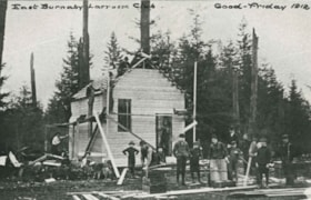
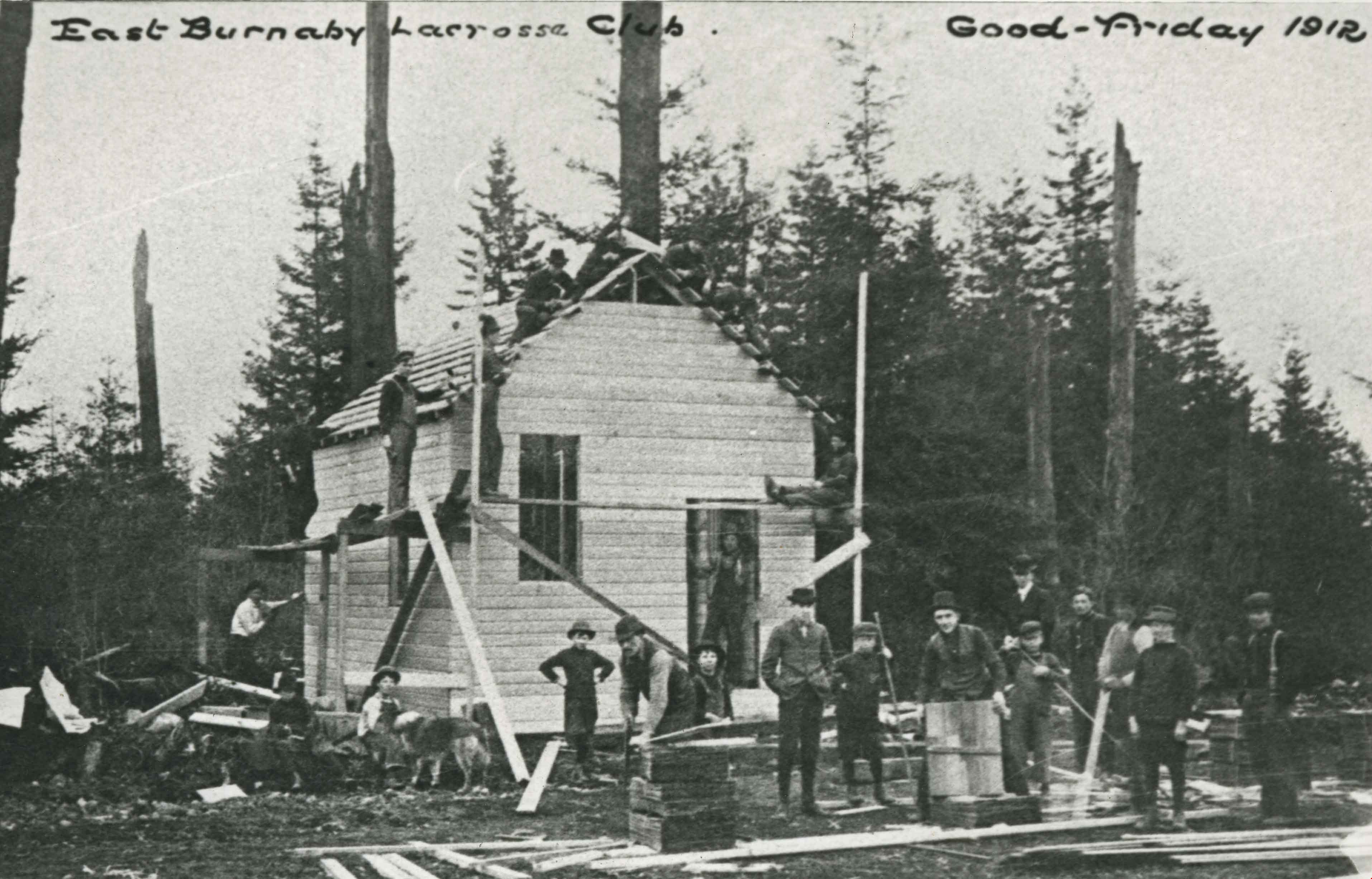
East Burnaby Lacrosse Club Clubhouse
https://search.heritageburnaby.ca/link/archivedescription35358
- Repository
- City of Burnaby Archives
- Date
- 1912 (date of original), copied 1986
- Collection/Fonds
- Burnaby Historical Society fonds
- Description Level
- Item
- Physical Description
- 1 photograph : b&w ; 12.7 x 17.8 cm print
- Scope and Content
- Photograph of the East Burnaby Lacrosse Club clubhouse building bee on the grounds of Edmonds Street School. Sitting on the scaffolding against the pole is George Leaf, manager of the club. The East Burnaby Lacrosse Club members scrounged materials and built the clubhouse in one day.
- Repository
- City of Burnaby Archives
- Date
- 1912 (date of original), copied 1986
- Collection/Fonds
- Burnaby Historical Society fonds
- Subseries
- Pioneer Tales subseries
- Physical Description
- 1 photograph : b&w ; 12.7 x 17.8 cm print
- Description Level
- Item
- Record No.
- 204-215
- Access Restriction
- No restrictions
- Reproduction Restriction
- No known restrictions
- Accession Number
- BHS1988-03
- Scope and Content
- Photograph of the East Burnaby Lacrosse Club clubhouse building bee on the grounds of Edmonds Street School. Sitting on the scaffolding against the pole is George Leaf, manager of the club. The East Burnaby Lacrosse Club members scrounged materials and built the clubhouse in one day.
- Subjects
- Buildings - Recreational
- Organizations
- Media Type
- Photograph
- Notes
- Title based on contents of photograph
- Annotation at top of photograph reads, "East Burnaby Lacrosse Club / Good Friday 1912"
- Geographic Access
- Edmonds Street
- Street Address
- 7355 Canada Way
- Historic Neighbourhood
- Edmonds (Historic Neighbourhood)
- Planning Study Area
- Edmonds Area
Images
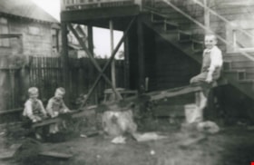
Grant family
https://search.heritageburnaby.ca/link/archivedescription36867
- Repository
- City of Burnaby Archives
- Date
- 1914 (date of original), copied 1992
- Collection/Fonds
- Burnaby Historical Society fonds
- Description Level
- Item
- Physical Description
- 1 photograph : b&w ; 8.3 x 12.7 cm print
- Scope and Content
- Photograph of the Grant brothers; eldest Bill, (above), with George and Harry on a teeter totter outside the family home at 2540 Marlborough Avenue (renumbered 6591 Marlborough Avenue).
- Repository
- City of Burnaby Archives
- Date
- 1914 (date of original), copied 1992
- Collection/Fonds
- Burnaby Historical Society fonds
- Subseries
- Burnaby Centennial Anthology subseries
- Physical Description
- 1 photograph : b&w ; 8.3 x 12.7 cm print
- Description Level
- Item
- Record No.
- 315-325
- Access Restriction
- No restrictions
- Reproduction Restriction
- No known restrictions
- Accession Number
- BHS1994-04
- Scope and Content
- Photograph of the Grant brothers; eldest Bill, (above), with George and Harry on a teeter totter outside the family home at 2540 Marlborough Avenue (renumbered 6591 Marlborough Avenue).
- Media Type
- Photograph
- Notes
- Title based on contents of photograph
- Geographic Access
- Marlborough Avenue
- Street Address
- 6591 Marlborough Avenue
- Historic Neighbourhood
- Central Park (Historic Neighbourhood)
- Planning Study Area
- Marlborough Area
Images


Inauguration of the water system at Burnaby
https://search.heritageburnaby.ca/link/archivedescription35938
- Repository
- City of Burnaby Archives
- Date
- July 16, 1912
- Collection/Fonds
- Burnaby Historical Society fonds
- Description Level
- Item
- Physical Description
- 1 photograph : b&w postcard ; 8.9 x 14.0 cm
- Scope and Content
- Photographic postcard of Reeve Weart addressing a crowd gathered around the bandstand in Central Park for the inauguration of Burnaby Water Works. The Reeve is standing as he looks towards the crowd. Other men are seated in a semi-circle inside the bandstand. This was known as "Splash Day."
- Repository
- City of Burnaby Archives
- Date
- July 16, 1912
- Collection/Fonds
- Burnaby Historical Society fonds
- Subseries
- Pioneer Tales subseries
- Physical Description
- 1 photograph : b&w postcard ; 8.9 x 14.0 cm
- Description Level
- Item
- Record No.
- 204-798
- Access Restriction
- No restrictions
- Reproduction Restriction
- No known restrictions
- Accession Number
- BHS1988-03
- Scope and Content
- Photographic postcard of Reeve Weart addressing a crowd gathered around the bandstand in Central Park for the inauguration of Burnaby Water Works. The Reeve is standing as he looks towards the crowd. Other men are seated in a semi-circle inside the bandstand. This was known as "Splash Day."
- Subjects
- Buildings - Recreational - Bandstands
- Persons - Crowds
- Officials - Mayors and Reeves
- Public Services - Utilities
- Public Services - Public Works
- Documentary Artifacts - Postcards
- Names
- Weart, R.W.
- Media Type
- Photograph
- Notes
- 1 b&w copy negative accompanying
- Annotation of back of postcard reads, "July 16 - 1912 / Inauguration of the water system at Burnaby"
- Geographic Access
- Central Park
- Imperial Street
- Street Address
- 3883 Imperial Street
- Historic Neighbourhood
- Central Park (Historic Neighbourhood)
- Planning Study Area
- Maywood Area
Images

Interview with Janet White May 10, 2005 - Track 1
https://search.heritageburnaby.ca/link/museumdescription4370
- Repository
- Burnaby Village Museum
- Date
- [195-] (interview content), interviewed May 10, 2005
- Collection/Fonds
- Burnaby Village Museum fonds
- Description Level
- Item
- Physical Description
- 1 sound recording (mp3) (0:03:12 min)
- Scope and Content
- Track 1: This portion of the recording pertains to Janet White’s school years and the activities and sports she participated in, formally and informally. She lived near 6th and Edmonds St., and then in the Cascades area, by Nithsdale St., and attended Schou Elementary. She attended many schools as …
- Repository
- Burnaby Village Museum
- Collection/Fonds
- Burnaby Village Museum fonds
- Series
- Museum Oral Histories series
- Subseries
- Growing Up in Burnaby subseries
- Description Level
- Item
- Physical Description
- 1 sound recording (mp3) (0:03:12 min)
- Material Details
- Interviewer: Tom Gooden Interviewee: Janet White Date of interview: May 10, 2005 Total Number of Tracks: 8 Total length of all Tracks: 0:31:34
- Scope and Content
- Track 1: This portion of the recording pertains to Janet White’s school years and the activities and sports she participated in, formally and informally. She lived near 6th and Edmonds St., and then in the Cascades area, by Nithsdale St., and attended Schou Elementary. She attended many schools as soon as they were built, attending Gilmore Avenue, then Cascade Heights, Alpha Junior High, Moscrop Secondary, and finally Burnaby Central Secondary. Play was unstructured, with the Cascades bush and the tunnel parallel to and going under Smith Avenue being favourite places to play.
- History
- Recording of an interview with Janet White recording by Tom Gooden on May 10 2005. This recording was completed for an exhibit, Growing Up in Burnaby, for the Burnaby Village Museum. Major themes discussed are growing up in Burnaby in the 1950s.
- Creator
- Burnaby Village Museum
- Names
- Gooden, Tom
- White, Janet
- Schou Street School
- Gilmore Avenue School
- Cascade Heights Elementary School
- Alpha Secondary School
- Moscrop Secondary School
- Burnaby Central Secondary School
- Geographic Access
- 6th Street
- Edmonds Street
- Accession Code
- BV017.45.1
- Access Restriction
- No restrictions
- Reproduction Restriction
- May be restricted by third party rights
- Date
- [195-] (interview content), interviewed May 10, 2005
- Media Type
- Sound Recording
- Planning Study Area
- Cascade-Schou Area
Audio Tracks
Interview with Janet White May 10, 2005 - Track 1, [195-] (interview content), interviewed May 10, 2005
Interview with Janet White May 10, 2005 - Track 1, [195-] (interview content), interviewed May 10, 2005
https://search.heritageburnaby.ca/media/hpo/_Data/_BVM_Sound_Recordings/Oral_Histories/2017_0045_0001_001.mp3
Interview with Sev Morin by Rod Fowler April 4, 1990 - Track 10
https://search.heritageburnaby.ca/link/oralhistory546
- Repository
- City of Burnaby Archives
- Date Range
- 1950-1990
- Length
- 00:09:22
- Summary
- This portion of the interview is about Sev Morin’s views about Burnaby’s identity and the irrelevance of municipal boundary lines for many functions; his identification of Burnaby’s heritage, ecological and educational “gems”; and musings about the next development phases for Burnaby
- Repository
- City of Burnaby Archives
- Summary
- This portion of the interview is about Sev Morin’s views about Burnaby’s identity and the irrelevance of municipal boundary lines for many functions; his identification of Burnaby’s heritage, ecological and educational “gems”; and musings about the next development phases for Burnaby
- Date Range
- 1950-1990
- Photo Info
- Sev Morin (left) of Severin's in Burnaby (formerly the Gai Paree) hosting a gala New Year's celebration, 1979. Item no. 480-712
- Length
- 00:09:22
- Subjects
- Public Services - Municipal Services
- Planning
- Industries
- Geographic Features - Parks
- Buildings - Recreational
- Interviewer
- Fowler, Rod
- Interview Date
- April 4, 1990
- Scope and Content
- Recording is of an interview with Severin "Sev" Morin, conducted by Rod Fowler. Sev Morin was one of eleven participants interviewed as part of the SFU/Burnaby Centennial Committee's oral history series titled, "Voices of Burnaby". The interview is mainly about Sev Morin’s banquet hall, restaurant and night club business on Kingsway, originally named the “Gai Paree Supper Club” (1947-1976) and later “Severin’s” (1976-1985) and “Diego’s” (1985-1994), its function as a Burnaby landmark, and the entertainment and political people he met through his business. He also describes his many volunteer activities in Burnaby, including member of the SFU Senate, Rotary Club, Variety Club and Telethon, fund raising for Burnaby Hospital, and tourism related groups, and his political work for the federal Liberal party. He talks about his parents’ origins, the lives of his brothers Rudy and Rene, and the family’s involvement in establishing the “Gai Paree”. He also shares his views about the business and cultural development of Burnaby. To view “Narrow By” terms for each track expand this description and see “Notes”.
- Biographical Notes
- Severin “Sev” Rene Morin was born September 21, 1927, in Bonneville, Alberta, to Rene Pierre Morin (1878-1963) and Anne Marie (nee Lachiver) Morin (1886-1956). Mr. and Mrs. R. P. Morin and their son Rene Francois (1905-1954) immigrated to Edmonton, Alberta, from France in 1913, where Rene Pierre Morin worked for the C.N.R. and a second son Adolphe “Rudy” Ferdinand (1922-1969) was born, followed by their third son Severin. In 1943, after R.P. Morin retired, the family moved to Burnaby to a house on Sperling Avenue. Sometime earlier the two older Morin brothers found work in Trail at the smelter and developed musical careers. In 1946/47 the Morin family purchased property on Kingsway and built a banquet hall, the “Gai Paree Supper Club”. Sev and Rudy Morin managed the club and Rene F. Morin moved to Burnaby to join them with his band. The supper club, with its live music and dance floor, became a popular meeting place and wedding venue, eventually expanding into a restaurant and nightclub in the 1970s. The “Gai Paree” was renamed “Severin’s” in 1976 and “Diego’s” in 1985, closing finally in 1994. Sev Morin’s business life included three record stores which he owned with his friend Jack Cullen. Through these businesses Sev Morin was well known in the entertainment and hospitality industry. He and his restaurant also hosted political and social events that made the restaurant a community landmark. Sev Morin contributed many volunteer hours to community and charitable organizations, including an appointment to the SFU Senate, fundraising for the Burnaby Hospital, Director of the Variety Club and Rotary Club, and consultant for a variety of tourism related ventures. He also was active in the federal Liberal Party. Sev Morin and his wife Pauline married in 1950 and had three children. Sev Morin died at age 86 on March 28, 2014.
- Total Tracks
- 10
- Total Length
- 00:56:44
- Interviewee Name
- Morin, Severin "Sev"
- Interviewer Bio
- Rod Fowler returned to university as a mature student in the 1980s after working about twenty years in the field of economics and computerization in business in England, Europe and Western Canada. He graduated with a BA from SFU in both History and Sociology in 1987, his MA degree in Geography in 1989, and his PhD in Cultural Geography at SFU. He taught courses in Geography, Sociology, History and Canadian Studies at several Lower Mainland colleges, before becoming a full time member of the Geography Department at Kwantlen University College.
- Collection/Fonds
- SFU/Burnaby Centennial Committee fonds
- Transcript Available
- Transcript available
- Media Type
- Sound Recording
- Web Notes
- Interviews were digitized in 2015 allowing them to be accessible on Heritage Burnaby. The digitization project was initiated by the Community Heritage Commission with support from City of Burnaby Council.
Images

Audio Tracks
Track ten of interview with Sev Morin
Track ten of interview with Sev Morin
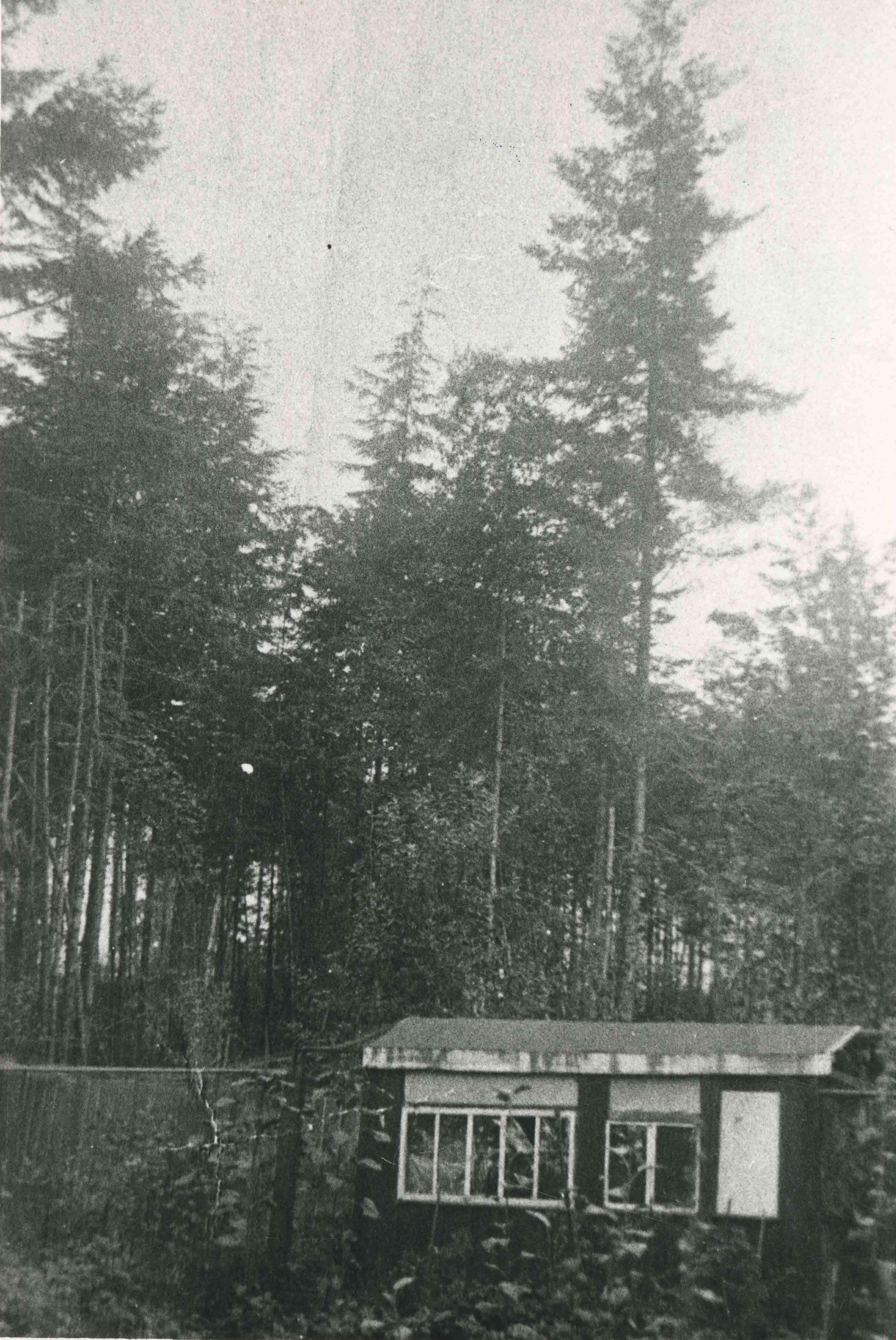
https://search.heritageburnaby.ca/media/hpo/_Data/_Archives_Oral_Histories/_Unrestricted/MSS187-021/MSS187-021_Track%2010.mp3![Jim Phillips' photography shack, [1912] thumbnail](/media/hpo/_Data/_Archives_Images/_Unrestricted/487/487-025.jpg?width=280)
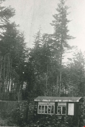
Jim Phillips' photography shack
https://search.heritageburnaby.ca/link/archivedescription57725
- Repository
- City of Burnaby Archives
- Date
- [1912]
- Collection/Fonds
- J.W. Phillips fonds
- Description Level
- Item
- Physical Description
- 1 photograph : b&w glass negative ; 15.5 x 11 cm
- Scope and Content
- Photograph of the little shack where Jim Phillips, a photographer and artist, did his developing and painting. It was located next to the Holmes family home on Ellesmere Avenue. Note the thick bushland. Jim Phillips was killed in the First World War.
- Repository
- City of Burnaby Archives
- Date
- [1912]
- Collection/Fonds
- J.W. Phillips fonds
- Physical Description
- 1 photograph : b&w glass negative ; 15.5 x 11 cm
- Material Details
- Emulsion measures 15.5 x 11 cm on the glass; entire glass plate measures 16 x 12 cm
- Description Level
- Item
- Record No.
- 487-025
- Access Restriction
- No restrictions
- Reproduction Restriction
- No known restrictions
- Accession Number
- 2008-18
- Scope and Content
- Photograph of the little shack where Jim Phillips, a photographer and artist, did his developing and painting. It was located next to the Holmes family home on Ellesmere Avenue. Note the thick bushland. Jim Phillips was killed in the First World War.
- Subjects
- Buildings - Recreational
- Media Type
- Photograph
- Photographer
- Phillips, James William "Jim"
- Notes
- Title based on contents of photograph
- Geographic Access
- Ellesmere Avenue
- Historic Neighbourhood
- Capitol Hill (Historic Neighbourhood)
- Planning Study Area
- Capitol Hill Area
Images
![Jim Phillips' photography shack, [1912] thumbnail](/media/hpo/_Data/_Archives_Images/_Unrestricted/487/487-025.jpg)
Jim Phillips' photography shack
https://search.heritageburnaby.ca/link/archivedescription35840
- Repository
- City of Burnaby Archives
- Date
- 1912 (date of original), copied 1986
- Collection/Fonds
- Burnaby Historical Society fonds
- Description Level
- Item
- Physical Description
- 1 photograph : b&w ; 12.7 x 17.8 cm print
- Scope and Content
- Photograph of the little shack where Jim Phillips, a photographer and artist, did his developing and painting. It was located next to the Holmes family home on Ellesmere Avenue. Note the thick bushland. Jim Phillips was killed in the First World War.
- Repository
- City of Burnaby Archives
- Date
- 1912 (date of original), copied 1986
- Collection/Fonds
- Burnaby Historical Society fonds
- Subseries
- Pioneer Tales subseries
- Physical Description
- 1 photograph : b&w ; 12.7 x 17.8 cm print
- Description Level
- Item
- Record No.
- 204-699
- Access Restriction
- No restrictions
- Reproduction Restriction
- No known restrictions
- Accession Number
- BHS1988-03
- Scope and Content
- Photograph of the little shack where Jim Phillips, a photographer and artist, did his developing and painting. It was located next to the Holmes family home on Ellesmere Avenue. Note the thick bushland. Jim Phillips was killed in the First World War.
- Subjects
- Buildings - Recreational
- Media Type
- Photograph
- Photographer
- Phillips, James William "Jim"
- Notes
- Title based on contents of photograph
- Item no. 487-026 and 204-703 are also of this building
- Geographic Access
- Ellesmere Avenue
- Historic Neighbourhood
- Capitol Hill (Historic Neighbourhood)
- Planning Study Area
- Capitol Hill Area
Images
![Jim Phillips' photography shack, [1912] (date of original), copied 1986 thumbnail](/media/hpo/_Data/_Archives_Images/_Unrestricted/204/204-703.jpg?width=280)
Jim Phillips' photography shack
https://search.heritageburnaby.ca/link/archivedescription35844
- Repository
- City of Burnaby Archives
- Date
- [1912] (date of original), copied 1986
- Collection/Fonds
- Burnaby Historical Society fonds
- Description Level
- Item
- Physical Description
- 1 photograph : b&w ; 12.7 x 17.8 cm print
- Scope and Content
- Photograph of the little shack where Jim Phillips, a photographer and artist, did his developing and painting. It was located next to the Holmes family home on Ellesmere Avenue. Note the thick bushland. Jim Phillips was killed in the First World War.
- Repository
- City of Burnaby Archives
- Date
- [1912] (date of original), copied 1986
- Collection/Fonds
- Burnaby Historical Society fonds
- Subseries
- Pioneer Tales subseries
- Physical Description
- 1 photograph : b&w ; 12.7 x 17.8 cm print
- Description Level
- Item
- Record No.
- 204-703
- Access Restriction
- No restrictions
- Reproduction Restriction
- No known restrictions
- Accession Number
- BHS1988-03
- Scope and Content
- Photograph of the little shack where Jim Phillips, a photographer and artist, did his developing and painting. It was located next to the Holmes family home on Ellesmere Avenue. Note the thick bushland. Jim Phillips was killed in the First World War.
- Subjects
- Buildings - Recreational
- Media Type
- Photograph
- Photographer
- Phillips, James William "Jim"
- Notes
- Title based on contents of photograph
- Item no. 204-699 and 487-026 are also of this building
- Geographic Access
- Ellesmere Avenue
- Historic Neighbourhood
- Capitol Hill (Historic Neighbourhood)
- Planning Study Area
- Capitol Hill Area
Images
![Jim Phillips' photography shack, [1912] (date of original), copied 1986 thumbnail](/media/hpo/_Data/_Archives_Images/_Unrestricted/204/204-703.jpg)
Kindergartners blowing soap bubbles
https://search.heritageburnaby.ca/link/archivedescription52967
- Repository
- City of Burnaby Archives
- Date
- May 1960
- Collection/Fonds
- Burnaby Historical Society fonds
- Description Level
- Item
- Physical Description
- 1 photograph : b&w ; 7.5 x 11.5 cm
- Scope and Content
- Photograph of kindergartners from the Tinkerbell Cooperative Kindergarten blowing soap bubbles with the help of one of their teachers. They are standing in a field outside in small groups, watching each other blow soap bubbles.
- Repository
- City of Burnaby Archives
- Date
- May 1960
- Collection/Fonds
- Burnaby Historical Society fonds
- Subseries
- Tinkerbell Kindergarten subseries
- Physical Description
- 1 photograph : b&w ; 7.5 x 11.5 cm
- Description Level
- Item
- Record No.
- 246-007
- Access Restriction
- No restrictions
- Reproduction Restriction
- Reproduce for fair dealing purposes only
- Accession Number
- BHS1990-12
- Scope and Content
- Photograph of kindergartners from the Tinkerbell Cooperative Kindergarten blowing soap bubbles with the help of one of their teachers. They are standing in a field outside in small groups, watching each other blow soap bubbles.
- Media Type
- Photograph
- Notes
- Title based on contents of photograph
- Stamp on recto of photograph reads: "MAY 60"
- Note on verso of photograph reads: "blowing soap bubbles"
Images

![Kitty Hill and Florence Hart boating on Deer Lake, [1910] thumbnail](/media/hpo/_Data/_Archives_Images/_Unrestricted/477/477-090.jpg?width=280)
Kitty Hill and Florence Hart boating on Deer Lake
https://search.heritageburnaby.ca/link/archivedescription38771
- Repository
- City of Burnaby Archives
- Date
- [1910]
- Collection/Fonds
- Peers Family and Hill Family fonds
- Description Level
- Item
- Physical Description
- 1 photograph : b&w ; 8 x 10 cm on page 11.5 x 14 cm (pasted in album)
- Scope and Content
- Photograph of Kitty Hill (turned away) and Florence Hart boating on Deer Lake. Written around the border of the photograph is the following: "You would look away just as I took this. Do you remember how cross I was about it?" The boathouse is most likely that belonging to Kitty's father, Claude H…
- Repository
- City of Burnaby Archives
- Date
- [1910]
- Collection/Fonds
- Peers Family and Hill Family fonds
- Physical Description
- 1 photograph : b&w ; 8 x 10 cm on page 11.5 x 14 cm (pasted in album)
- Description Level
- Item
- Record No.
- 477-090
- Access Restriction
- No restrictions
- Reproduction Restriction
- No known restrictions
- Accession Number
- 2007-12
- Scope and Content
- Photograph of Kitty Hill (turned away) and Florence Hart boating on Deer Lake. Written around the border of the photograph is the following: "You would look away just as I took this. Do you remember how cross I was about it?" The boathouse is most likely that belonging to Kitty's father, Claude Hill, on Deer Lake.
- Subjects
- Buildings - Residential - Boathouses
- Recreational Activities - Boating
- Geographic Features - Lakes and Ponds
- Media Type
- Photograph
- Notes
- Title based on contents of photograph
- Geographic Access
- Deer Lake
- Historic Neighbourhood
- Burnaby Lake (Historic Neighbourhood)
Images
![Kitty Hill and Florence Hart boating on Deer Lake, [1910] thumbnail](/media/hpo/_Data/_Archives_Images/_Unrestricted/477/477-090.jpg)
![Love farmhouse swing, [ca. 1918] (date of original), copied 1989 thumbnail](/media/hpo/_Data/_BVM_Images/2018/2018_0041_0192_001.jpg?width=280)
Love farmhouse swing
https://search.heritageburnaby.ca/link/museumdescription10012
- Repository
- Burnaby Village Museum
- Date
- [ca. 1918] (date of original), copied 1989
- Collection/Fonds
- Burnaby Village Museum fonds
- Description Level
- Item
- Physical Description
- 1 photograph : b&w negative ; 35 mm
- Scope and Content
- Photograph of an an unidentified woman sitting on a large wood framed swing with a group of unidentified children sitting at her feet.The swing is in the yard of the Love farmhouse. There is a tall tree to the right and several trees in the background, the ground is covered in tall grass.
- Repository
- Burnaby Village Museum
- Collection/Fonds
- Burnaby Village Museum fonds
- Series
- Jesse Love farmhouse series
- Subseries
- Love family photographs subseries
- Description Level
- Item
- Physical Description
- 1 photograph : b&w negative ; 35 mm
- Scope and Content
- Photograph of an an unidentified woman sitting on a large wood framed swing with a group of unidentified children sitting at her feet.The swing is in the yard of the Love farmhouse. There is a tall tree to the right and several trees in the background, the ground is covered in tall grass.
- Geographic Access
- Cumberland Street
- Street Address
- 7651 Cumberland Street
- Accession Code
- BV018.41.192
- Access Restriction
- No restrictions
- Reproduction Restriction
- May be restricted by third party rights
- Date
- [ca. 1918] (date of original), copied 1989
- Media Type
- Photograph
- Historic Neighbourhood
- East Burnaby (Historic Neighbourhood)
- Planning Study Area
- Cariboo-Armstrong Area
- Scan Resolution
- 2400
- Scan Date
- 4-Mar-2019
- Scale
- 100
- Notes
- Title based on contents of photograph
- 1 b&w copy print accompanying
Images
![Love farmhouse swing, [ca. 1918] (date of original), copied 1989 thumbnail](/media/hpo/_Data/_BVM_Images/2018/2018_0041_0192_001.jpg)

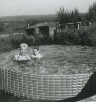
Madelaine and Janet Anderson in their pool
https://search.heritageburnaby.ca/link/archivedescription37445
- Repository
- City of Burnaby Archives
- Date
- 1961 (date of original), copied 1991
- Collection/Fonds
- Burnaby Historical Society fonds
- Description Level
- Item
- Physical Description
- 1 photograph : b&w ; 4.0 x 3.7 cm print on contact sheet 20.2 x 25.4 cm
- Scope and Content
- Photograph of mother and daughter Madelaine and Janet Anderson in the swimming pool behind their home at 3908 Norland Avenue (previously numbered 4437 Norland Avenue).
- Repository
- City of Burnaby Archives
- Date
- 1961 (date of original), copied 1991
- Collection/Fonds
- Burnaby Historical Society fonds
- Subseries
- Burnaby Image Bank subseries
- Physical Description
- 1 photograph : b&w ; 4.0 x 3.7 cm print on contact sheet 20.2 x 25.4 cm
- Description Level
- Item
- Record No.
- 370-033
- Access Restriction
- No restrictions
- Reproduction Restriction
- No restrictions
- Accession Number
- BHS1999-03
- Scope and Content
- Photograph of mother and daughter Madelaine and Janet Anderson in the swimming pool behind their home at 3908 Norland Avenue (previously numbered 4437 Norland Avenue).
- Media Type
- Photograph
- Notes
- Title based on contents of photograph
- 1 b&w copy negative accompanying
- Geographic Access
- Norland Avenue
- Street Address
- 3908 Norland Avenue
- Historic Neighbourhood
- Burnaby Lake (Historic Neighbourhood)
- Planning Study Area
- Douglas-Gilpin Area
Images
![Rosemount Viaduct, Aberdeen, [1900-1930] thumbnail](/media/hpo/_Data/_Archives_Images/_Unrestricted/550/550-142.jpg?width=280)
Rosemount Viaduct, Aberdeen
https://search.heritageburnaby.ca/link/archivedescription82571
- Repository
- City of Burnaby Archives
- Date
- [1900-1930]
- Collection/Fonds
- Hill family and Vidal family fonds
- Description Level
- Item
- Physical Description
- 1 photograph : b&w postcard ; 8.5 x 13.5 cm
- Scope and Content
- Photographic postcard shows Rosemount Viaduct in Aberdeen, Scotland. Statue on the left is the William Wallace statue. Building to the right is His Majesty's Theatre.
- Repository
- City of Burnaby Archives
- Date
- [1900-1930]
- Collection/Fonds
- Hill family and Vidal family fonds
- Physical Description
- 1 photograph : b&w postcard ; 8.5 x 13.5 cm
- Description Level
- Item
- Record No.
- 550-142
- Access Restriction
- No restrictions
- Reproduction Restriction
- No known restrictions
- Accession Number
- 2013-03
- Scope and Content
- Photographic postcard shows Rosemount Viaduct in Aberdeen, Scotland. Statue on the left is the William Wallace statue. Building to the right is His Majesty's Theatre.
- Media Type
- Photograph
- Notes
- Title based on contents of photograph
- Postcard on verso reads: "Published by T Lamb, 40, Market Street, Aberdeen"
Images
![Rosemount Viaduct, Aberdeen, [1900-1930] thumbnail](/media/hpo/_Data/_Archives_Images/_Unrestricted/550/550-142.jpg)
![Summer Gazebo, [1912] (date of original), copied 1986 thumbnail](/media/hpo/_Data/_Archives_Images/_Unrestricted/126/171-010.jpg?width=280)
Summer Gazebo
https://search.heritageburnaby.ca/link/archivedescription34989
- Repository
- City of Burnaby Archives
- Date
- [1912] (date of original), copied 1986
- Collection/Fonds
- Burnaby Historical Society fonds
- Description Level
- Item
- Physical Description
- 1 photograph : b&w ; 8.8 x 12.5 cm print
- Scope and Content
- Photograph of a luncheon group in the summer gazebo of the Patterson family home. The house was originally located at 7260 Edmonds Street (near Kingsway). It was relocated in 1955 to 7106 18th Avenue and is a city heritage site.
- Repository
- City of Burnaby Archives
- Date
- [1912] (date of original), copied 1986
- Collection/Fonds
- Burnaby Historical Society fonds
- Subseries
- Patterson family subseries
- Physical Description
- 1 photograph : b&w ; 8.8 x 12.5 cm print
- Description Level
- Item
- Record No.
- 171-010
- Access Restriction
- No restrictions
- Reproduction Restriction
- No known restrictions
- Accession Number
- BHS1986-20
- Scope and Content
- Photograph of a luncheon group in the summer gazebo of the Patterson family home. The house was originally located at 7260 Edmonds Street (near Kingsway). It was relocated in 1955 to 7106 18th Avenue and is a city heritage site.
- Subjects
- Events
- Buildings - Recreational - Gazebos
- Media Type
- Photograph
- Notes
- Title based on contents of photograph
- Geographic Access
- Edmonds Street
- 18th Avenue
- Street Address
- 7260 Edmonds Street
- 7106 18th Avenue
- Historic Neighbourhood
- Edmonds (Historic Neighbourhood)
- Planning Study Area
- Stride Avenue Area
Images
![Summer Gazebo, [1912] (date of original), copied 1986 thumbnail](/media/hpo/_Data/_Archives_Images/_Unrestricted/126/171-010.jpg)