Narrow Results By
Marlborough Neighbourhood
https://search.heritageburnaby.ca/link/landmark802
- Repository
- Burnaby Heritage Planning
- Associated Dates
- 1955-2008
- Heritage Value
- The Marlborough Neighbourhood is another residential area that was witness to rapid growth and subdivision during the 1950s and 1960s, creating primarily single-family housing stock. In the 1970s and 1980s, as the commercial district around Kingsway grew, so too did higher density housing projects such as townhomes and condominiums.
- Historic Neighbourhood
- Central Park (Historic Neighbourhood)
- Planning Study Area
- Marlborough Area
Images
Parkcrest Neighbourhood
https://search.heritageburnaby.ca/link/landmark671
- Repository
- Burnaby Heritage Planning
- Associated Dates
- 1925-1954
- Heritage Value
- On May 10, 1951, the Burnaby News-Courier reported on the new Parkcrest subdivision, saying: "Central Burnaby is the scenic locale of a successful attempt to produce modern houses economically and yet avoid the mass production effect common to other housing developments. That is one of the many highlights peculiar to the new Parkcrest development of 275 homes...By giving home purchasers a wide choice of finishes, extras and colours, hundreds of variations are possible on the six basic floor plans...Travelling time by car to Hastings and Granville from Parkcrest has been clocked at 15 minutes...Both primary and junior high schools are within walking distance. A modern shopping centre is planned for the future...Several streets are laid out in a straight but irregular manner, thus eliminating the prosaic side by side appearance block by block, as in other housing developments."
- Planning Study Area
- Parkcrest-Aubrey Area
Images
Sussex-Nelson Neighbourhood
https://search.heritageburnaby.ca/link/landmark838
- Repository
- Burnaby Heritage Planning
- Associated Dates
- 1955-2008
- Heritage Value
- The Sussex-Nelson Neighbourhood is located just south of Metrotown and in 1980 was characterised as the most populated of all of Burnaby's Planning Study areas. The area immediately south of Metrotown was initially developed as post-war 1950s housing stock, while the sector south of Rumble was developed after the 1960s and 1970s as single-family housing.
- Historic Neighbourhood
- Alta Vista (Historic Neighbourhood)
- Planning Study Area
- Sussex-Nelson Area
Images
Willingdon Heights Neighbourhood
https://search.heritageburnaby.ca/link/landmark670
- Repository
- Burnaby Heritage Planning
- Associated Dates
- 1925-1954
- Heritage Value
- Willingdon Heights was another new subdivision developed in Burnaby during the post-World War Two building boom. A brochure about the development published in 1948 proclaimed "the Willingdon Heights 500 home development project in Burnaby fulfills its promise to provide a self-contained community for former members of the armed services and their families...the largest single veteran housing project in Canada as far as homes for individual ownership is concerned, Willingdon Heights development was planned by the Central Mortgage and Housing Corporation...At this date the earlier built rows of homes have passable roads and the owners are improving lawns and gardens in spare time...eventually additional stores and professional services will be installed and recreational projects will add to the amenities of a community of congenial residents..."
- Planning Study Area
- Willingdon Heights Area
Images
Willingdon Heights United Church
https://search.heritageburnaby.ca/link/landmark658
- Repository
- Burnaby Heritage Planning
- Description
- Church building.
- Associated Dates
- 1951
- Street View URL
- Google Maps Street View
- Repository
- Burnaby Heritage Planning
- Geographic Access
- Parker Street
- Associated Dates
- 1951
- Description
- Church building.
- Heritage Value
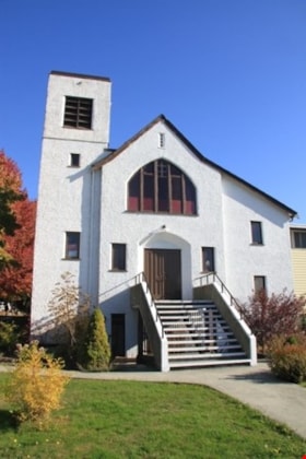
- This church was built to serve a 500-home subdivision known as Willingdon Heights–Canada’s largest single veteran’s housing project created by the Central Mortgage and Housing Corporation and constructed by the Whitsell Construction Company in 1948. The church building was designed as a simplified Gothic Revival church with a tall front tower and Gothic pointed-arch stained glass window and entrance. This church was designed by Vancouver architects Twizell & Twizell. Both Robert Twizell (1875-1964) and younger brother George Twizell (1885-1957) articled at Newcastle, England’s Hicks & Charlewood before arriving in Vancouver in late 1907 or early 1908, with George working for Robert until they established a partnership a few years later. Their firm lasted for nearly half a century and was well known for its numerous church designs.
- Locality
- Vancouver Heights
- Historic Neighbourhood
- Vancouver Heights (Historic Neighbourhood)
- Planning Study Area
- Willingdon Heights Area
- Architect
- Twizell & Twizell
- Area
- 1808.82
- Contributing Resource
- Building
- Ownership
- Private
- Street Address
- 4304 Parker Street
- Street View URL
- Google Maps Street View
Images
Brentwood Neighbourhood
https://search.heritageburnaby.ca/link/landmark780
- Repository
- Burnaby Heritage Planning
- Associated Dates
- 1955-2008
- Heritage Value
- Between 1955 and 2001, the Brentwood Neighbourhood developed into one of Burnaby's four official Town Centres. The Brentwood Town Centre serves the north-west sector of the Municipality, providing facilities such as commercial developments - of which the Brentwood Mall is the most significant. Under Burnaby's Residential Development Framework adopted by Council in 1981, the Town Centre also incorporated a full range of multi-housing types and forms in close relationship with their commercial facilities. In 1996, the City adopted the Brentwood Town Centre Development Plant to solidify the area as a focus of higher-density and higher-intensity residential and commercial opportunities, public transit and supporting leisure facilities.
- Planning Study Area
- Brentwood Area
Images
Brentwood Park Elementary School
https://search.heritageburnaby.ca/link/landmark679
- Repository
- Burnaby Heritage Planning
- Geographic Access
- Delta Avenue
- Associated Dates
- 1954
- Heritage Value
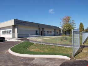
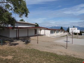
- Brentwood Park Elementary School was built during the post-World War Two housing boom in Burnaby and like other schools at the time, was similar in design - no basements, no second stories and no high stairways. New classrooms could be added in line with the original structure as was the case when two additions were put on between 1956 and 1958, a new classroom and library added in 1965-1966 and two more classrooms in 1969.
- Planning Study Area
- Brentwood Area
- Street Address
- 1455 Delta Avenue
- Street View URL
- Google Maps Street View
Images
Burnaby Mountain Neighbourhood
https://search.heritageburnaby.ca/link/landmark792
- Repository
- Burnaby Heritage Planning
- Associated Dates
- 1955-2008
- Heritage Value
- Burnaby Mountain had been dedicated as park in 1942, however the original park boundaries were reconsidered in 1952 with the development of the Trans Mountain Pipeline. Although the boundaries were adjusted to accommodate this project, significant conservation and park lands were left untouched. When, in 1962, the government of British Columbia determined the need for additional post-secondary facilities, Burnaby Mountain was chosen as the site for the new Simon Fraser University which opened in 1965. As early as 1964, the idea of establishing a townsite around the university had been discussed by Burnaby, but it was not until the mid-1990s that the idea came to fruition and by the early 2000s, a new housing development know as the UniverCity took shape on the mountain adjacent to the university.
- Historic Neighbourhood
- Barnet (Historic Neighbourhood)
- Planning Study Area
- Burnaby Mountain Area
Images
Cascade Heights School
https://search.heritageburnaby.ca/link/landmark691
- Repository
- Burnaby Heritage Planning
- Geographic Access
- Smith Avenue
- Associated Dates
- 1953
- Heritage Value
- Among the first new elementary schools to be built during the post-World War Two housing boom in Burnaby, Cascade Heights opened in 1953. Additions to the school were made in 1954, 1963 and 1969.
- Planning Study Area
- Cascade-Schou Area
- Street Address
- 4343 Smith Avenue
- Street View URL
- Google Maps Street View
Images
Cascade-Schou Neighbourhood
https://search.heritageburnaby.ca/link/landmark798
- Repository
- Burnaby Heritage Planning
- Associated Dates
- 1955-2008
- Heritage Value
- The Cascade-Schou neighbourhood, sometimes referred to as the Cascade Heights area, includes both the Burnaby General Hospital site, the Discovery Park facilities and is bordered on its eastern boundary by BCIT. Despite these health and science developments, the neighbourhood can still be considered to be a residential community. The housing stock includes single family homes as well as newer multi-family residences that developed throughout the 1980s and 1990s.
- Historic Neighbourhood
- Broadview (Historic Neighbourhood)
- Planning Study Area
- Cascade-Schou Area
Images
Central Park Neighbourhood
https://search.heritageburnaby.ca/link/landmark688
- Repository
- Burnaby Heritage Planning
- Associated Dates
- 1925-1954
- Heritage Value
- Although still largely a rural area during the 1920s, subdivisions began appearing in the Central Park neighbourhood at this time. Development was slowed by the Great Depression of the 1930s but the influx of commercial buildings and new housing initiatives in the post-war boom led to a period of rapid growth especially in the Garden Village subdivision which was undertaken in 1953 with the plan to build 500 modern homes in the 140-acre site. Despite the closure of the interurban line in 1953, the neighbourhood remained an active commercial and residential centre.
- Historic Neighbourhood
- Central Park (Historic Neighbourhood)
- Planning Study Area
- Maywood Area
Images
East Burnaby Neighbourhood
https://search.heritageburnaby.ca/link/landmark712
- Repository
- Burnaby Heritage Planning
- Associated Dates
- 1925-1954
- Heritage Value
- After a lull in construction during the World War I period, East Burnaby Neighbourhood's growth resumed during the 1920s when many homes and businesses were constructed. The post-World War Two period also saw rapid construction and the creation of new housing developments in response to a population boom. The neighbourhood remained a primarily single-family residential area.
- Historic Neighbourhood
- Edmonds (Historic Neighbourhood)
- Planning Study Area
- Stride Avenue Area
Images
Edmonds Neighbourhood
https://search.heritageburnaby.ca/link/landmark704
- Repository
- Burnaby Heritage Planning
- Associated Dates
- 1925-1954
- Heritage Value
- The historic growth of Edmonds as a neighbourhood was based on its strategic location on the early interurban line between Vancouver and New Westminster. Even by 1980 when a survey of the residential neighbourhoods was conducted, a full 25% of homes in the area predated 1930. The 1950s was a period of strong housing development, with both single-family and multi-family units being constructed. Although Burnaby's City Hall was moved from Kingsway and Edmonds in the early 1950s, Edmonds remained an important centre in the community.
- Historic Neighbourhood
- Edmonds (Historic Neighbourhood)
- Planning Study Area
- Stride Avenue Area
Images
Garden Village Neighbourhood
https://search.heritageburnaby.ca/link/landmark800
- Repository
- Burnaby Heritage Planning
- Associated Dates
- 1955-2008
- Heritage Value
- Bounded by Moscrop Street to the north, Kingsway and Grange to the south, Willingdon to the east and Boundary Road to the west, the Garden Village Neighbourhood is characterised as a primarily residential area that is well-served due to its proximity to commercial, park and business centres. The north-east corner of the neighbourhood is a typical 1950s subdivision of mostly single family homes located on an irregular street pattern, while the remaining areas saw some transition to multi-family housing types throughout the 1970s and up to the current time.
- Historic Neighbourhood
- Central Park (Historic Neighbourhood)
- Planning Study Area
- Garden Village Area
Images
J.A. Thurston House 'Altese'
https://search.heritageburnaby.ca/link/landmark511
- Repository
- Burnaby Heritage Planning
- Description
- The J.A. Thurston House is a very large, two and one-half storey plus basement wood-frame Arts and Crafts style house. It is located on the south side of Thurston Street, near Kingsway and the SkyTrain (formerly the interurban tramline route), within the Metrotown area of Burnaby and is now part of…
- Associated Dates
- 1912
- Formal Recognition
- Heritage Designation, Community Heritage Register
- Other Names
- John A. & Sarah Thurston House
- Street View URL
- Google Maps Street View
- Repository
- Burnaby Heritage Planning
- Other Names
- John A. & Sarah Thurston House
- Geographic Access
- Thurston Street
- Associated Dates
- 1912
- Formal Recognition
- Heritage Designation, Community Heritage Register
- Enactment Type
- Bylaw No. 9934
- Enactment Date
- 09/08/1993
- Description
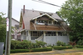
- The J.A. Thurston House is a very large, two and one-half storey plus basement wood-frame Arts and Crafts style house. It is located on the south side of Thurston Street, near Kingsway and the SkyTrain (formerly the interurban tramline route), within the Metrotown area of Burnaby and is now part of a large apartment complex.
- Heritage Value
- The J.A. Thurston House demonstrates Burnaby's real estate and construction boom along the interurban tramline in 1911. The house was built for John Albert Thurston (1874-1944) and his wife Sarah Sedona Thurston (1879-1961). Typical of the entrepreneurial spirit of the age, John Thurston, a manager for the Leckie Shoe Company Limited in Vancouver, was also involved in real estate development, and purchased a twenty-one lot subdivision consisting of 3.2 hectares bound by the interurban tramline right-of-way to the south, Boundary Road to the west and Smith Street (now Thurston Street) to the north. Additionally, the J.A. Thurston House is an excellent, high quality example of an Arts and Crafts style dwelling, with numerous notable design elements such as the battered piers, the elaborate second storey dormer and stained glass windows with landscape and seascape motifs. The enormous scale of the house reflects a time when large families were common and domestic servants were needed to run the household. Indicative of the labour-saving devices and luxury features being introduced at the high end of the housing market, it was equipped with a built-in vacuum system, refrigeration, servant summoning devices and a round safe built into a fireplace mantle. The J.A. Thurston House also represents the proliferation during the Edwardian era of homes built from pattern books and standardized designs as a means to expedite the construction process and offer competitive costs.
- Defining Elements
- Key elements that define the heritage character of the J.A. Thurston House include its: - location on Thurston Street, in the old Central Park district - residential form, scale and massing as exemplified by its two and one-half storey plus above-ground basement height and regular, rectangular plan - Arts and Crafts style details such as the picturesque roofline, deep open eaves with exposed purlins, narrow lapped wooden siding on the first storey and cedar shingle siding on the upper storeys - broad and unusually steep side gabled roof, clad with cedar shingles - deeply-recessed full open front verandah with complementary recessed balcony in second storey dormer, incorporating both a gabled roof and shed roof - twinned and triple square bracketed columns on the verandahs and balcony - decorative battered verandah piers, supported on exposed beams - irregular fenestration, including: double-hung wooden-sash windows; picture windows; casement windows; and several stained glass windows with landscape and seascape motifs - tall brick external chimney on east facade - original interior features such as fireplaces, and wooden trim and floors
- Historic Neighbourhood
- Central Park (Historic Neighbourhood)
- Planning Study Area
- Garden Village Area
- Function
- Primary Historic--Single Dwelling
- Primary Current--Single Dwelling
- Community
- Burnaby
- Cadastral Identifier
- 018-224-113
- Boundaries
- The J.A. Thurston House is comprised of a single residential lot located at 3762 Thurston Street, Burnaby.
- Area
- 3880
- Contributing Resource
- Building
- Ownership
- Private
- Street Address
- 3762 Thurston Street
- Street View URL
- Google Maps Street View
Images
Marlborough Elementary School
https://search.heritageburnaby.ca/link/landmark695
- Repository
- Burnaby Heritage Planning
- Geographic Access
- Marlborough Avenue
- Associated Dates
- 1950
- Heritage Value
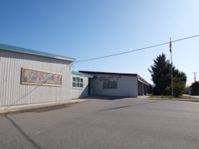
- Marlborough Elementary School was built in 1950 and was the second elementary school to be built in Burnaby after the start of the World War Two housing boom. Its design helped establish the general plans for future schools built in the city during this period - no basements, second stories or high stairways. Classrooms could easily be added, in line, as the need arose. There were additions made to Marlborough in 1952, 1961, 1967 and 1971.
- Historic Neighbourhood
- Central Park (Historic Neighbourhood)
- Planning Study Area
- Marlborough Area
- Street Address
- 6060 Marlborough Avenue
- Street View URL
- Google Maps Street View
Images
Maywood Neighbourhood
https://search.heritageburnaby.ca/link/landmark801
- Repository
- Burnaby Heritage Planning
- Associated Dates
- 1955-2008
- Heritage Value
- Burnaby's Maywood Neighbourhood consists of the Metrotown Town Centre - one of four Town Centres in the City. Metrotown is one of the region's most developed and fastest growing centres. It is served by the first SkyTrain line developed in the mid-1980s and anchored by B.C.'s largest shopping and entertainment complex. As an older centre that has progressively added new developments over the years, Metrotown offers a range of housing types and tenures from three-storey walk-up apartments to modern residential towers.
- Historic Neighbourhood
- Central Park (Historic Neighbourhood)
- Planning Study Area
- Maywood Area
Images
McPherson Park Junior High School
https://search.heritageburnaby.ca/link/landmark710
- Repository
- Burnaby Heritage Planning
- Associated Dates
- 1951-1993
- Street View URL
- Google Maps Street View
- Repository
- Burnaby Heritage Planning
- Geographic Access
- Rumble Street
- Associated Dates
- 1951-1993
- Heritage Value
- In 1950, the Burnaby School Inspector reported: "the recent development of a number of large housing projects and the continuing growth of new homes in settled areas are compelling the Board to consider a building program of major proportions...now under construction, including McPherson Park with 21 classrooms." Enrolment in its first year was 686 students. In the late 1980s and early 1990s, junior high schools were replaced with expanded secondary schools encompassing grades 7 through 12; as a result, McPherson Park Junior High was closed and Burnaby South Secondary School opened.
- Historic Neighbourhood
- Alta Vista (Historic Neighbourhood)
- Planning Study Area
- Clinton-Glenwood Area
- Street Address
- 5455 Rumble Street
- Street View URL
- Google Maps Street View
Morley-Buckingham Neighbourhood
https://search.heritageburnaby.ca/link/landmark829
- Repository
- Burnaby Heritage Planning
- Associated Dates
- 1955-2008
- Heritage Value
- In the 1980 "Residential Neighbourhood Environment Study," the Morley-Buckingham Neighbourhood is described as "perhaps Burnaby's most prestigious residential area. The lots are larger than most other areas of the Municipality and this, along with the new expensive housing developed over the past 10 years, has created a very desirable residential neighbourhood...The older area of Buckingham lies at the lower edge of the slope and here the homes and streets are more uniform and aged between 20 and 25 years old...to the east of Canada Way lies...a cluster townhouse development."
- Historic Neighbourhood
- Burnaby Lake (Historic Neighbourhood)
- Planning Study Area
- Morley-Buckingham Area
Images
Oakalla Neighbourhood
https://search.heritageburnaby.ca/link/landmark804
- Repository
- Burnaby Heritage Planning
- Associated Dates
- 1955-2008
- Heritage Value
- The phasing out and demolition of the Oakalla Prison farm allowed for the planned development of the Oakalla Neighbourhood in the 1980s. By 1991, the City of Burnaby had adopted the Oakalla Development Plan which called for the transfer of land to the Deer Lake Park reserve as well as the creation of a new residential area consisting of multi-family housing types.
- Historic Neighbourhood
- Central Park (Historic Neighbourhood)
- Planning Study Area
- Oakalla Area

