Narrow Results By
Decade
- 2020s 237
- 2010s 279
- 2000s 1537
- 1990s
- 1980s 1544
- 1970s 3675
- 1960s 1620
- 1950s 1935
- 1940s
- 1930s 2359
- 1920s 2566
- 1910s
- 1900s 830
- 1890s 244
- 1880s 161
- 1870s 72
- 1860s 120
- 1850s 14
- 1840s 6
- 1830s 3
- 1820s 3
- 1810s 4
- 1800s 4
- 1790s 3
- 1780s 3
- 1770s 3
- 1760s 3
- 1750s 3
- 1740s 3
- 1730s 3
- 1720s 3
- 1710s 3
- 1700s 3
- 1690s 3
- 1680s 3
- 1670s 2
- 1660s 2
- 1650s 2
- 1640s 2
- 1630s 2
- 1620s 2
- 1610s 2
- 1600s 2
- 1590s 1
- 1580s 1
- 1570s 1
- 1560s 1
- 1550s 1
- 1540s 1
- 1530s 1
- 1520s 2
- 1510s 1
- 1500s 1
- 1490s 1
- 1480s 1
Subject
- Accidents 3
- Accidents - Automobile Accidents 17
- Accidents - Train Accidents 7
- Advertising Medium 1
- Advertising Medium - Signs and Signboards 19
- Aerial Photographs 8
- Agricultural Tools and Equipment 6
- Agricultural Tools and Equipment - Cultivators 2
- Agricultural Tools and Equipment - Gardening Equipment 4
- Agricultural Tools and Equipment - Plows 4
- Agricultural Tools and Equipment - Tractors 1
- Agriculture 8
Creator
- Adams, J. 1
- Addington, H.E. 1
- Alberta Photo Company 1
- Anderson, Robert "Bob" 2
- Architectural drawing by Harold Cullerne 1
- Arranged and edited by Rhonda Ross and Alex W. Fraser 1
- Balkin, Jack 1
- Ballentine, Teresa 6
- Barrowclough, G.A. 3
- Barrowclough, George Alfred 5
- Bartel, Mario 634
- Battersby, Frank 24
![4200 Block Cambridge Street, [1940] (date of original), copied 1991 thumbnail](/media/hpo/_Data/_Archives_Images/_Unrestricted/370/370-409.jpg?width=280)
4200 Block Cambridge Street
https://search.heritageburnaby.ca/link/archivedescription37821
- Repository
- City of Burnaby Archives
- Date
- [1940] (date of original), copied 1991
- Collection/Fonds
- Burnaby Historical Society fonds
- Description Level
- Item
- Physical Description
- 1 photograph : b&w ; 3.9 x 2.6 cm print on contact sheet 20.3 x 26.4 cm
- Scope and Content
- Photograph of a dog sitting beside the sidewalk on the 4200 block of Cambridge Street.
- Repository
- City of Burnaby Archives
- Date
- [1940] (date of original), copied 1991
- Collection/Fonds
- Burnaby Historical Society fonds
- Subseries
- Burnaby Image Bank subseries
- Physical Description
- 1 photograph : b&w ; 3.9 x 2.6 cm print on contact sheet 20.3 x 26.4 cm
- Description Level
- Item
- Record No.
- 370-409
- Access Restriction
- No restrictions
- Reproduction Restriction
- No known restrictions
- Accession Number
- BHS1999-03
- Scope and Content
- Photograph of a dog sitting beside the sidewalk on the 4200 block of Cambridge Street.
- Subjects
- Animals - Dogs
- Media Type
- Photograph
- Notes
- Title based on contents of photograph
- 1 b&w copy negative accompanying
- Negative has a pink cast
- Geographic Access
- Cambridge Street
- Historic Neighbourhood
- Vancouver Heights (Historic Neighbourhood)
- Planning Study Area
- Burnaby Heights Area
Images
![4200 Block Cambridge Street, [1940] (date of original), copied 1991 thumbnail](/media/hpo/_Data/_Archives_Images/_Unrestricted/370/370-409.jpg)
![4200 Block Cambridge Street, [ca. 1940] (date of original), copied 1991 thumbnail](/media/hpo/_Data/_Archives_Images/_Unrestricted/370/370-410.jpg?width=280)
4200 Block Cambridge Street
https://search.heritageburnaby.ca/link/archivedescription37822
- Repository
- City of Burnaby Archives
- Date
- [ca. 1940] (date of original), copied 1991
- Collection/Fonds
- Burnaby Historical Society fonds
- Description Level
- Item
- Physical Description
- 1 photograph : b&w ; 3.9 x 2.6 cm print on contact sheet 20.3 x 26.4 cm
- Scope and Content
- Photograph of a dog standing beside the sidewalk on the 4200 block of Cambridge Street. The back of a car can be seen on the right, and the road can be seen in the background.
- Repository
- City of Burnaby Archives
- Date
- [ca. 1940] (date of original), copied 1991
- Collection/Fonds
- Burnaby Historical Society fonds
- Subseries
- Burnaby Image Bank subseries
- Physical Description
- 1 photograph : b&w ; 3.9 x 2.6 cm print on contact sheet 20.3 x 26.4 cm
- Description Level
- Item
- Record No.
- 370-410
- Access Restriction
- No restrictions
- Reproduction Restriction
- No known restrictions
- Accession Number
- BHS1999-03
- Scope and Content
- Photograph of a dog standing beside the sidewalk on the 4200 block of Cambridge Street. The back of a car can be seen on the right, and the road can be seen in the background.
- Subjects
- Animals - Dogs
- Media Type
- Photograph
- Notes
- Title based on contents of photograph
- 1 b&w copy negative accompanying
- Negative has a pink cast
- Geographic Access
- Cambridge Street
- Historic Neighbourhood
- Vancouver Heights (Historic Neighbourhood)
- Planning Study Area
- Burnaby Heights Area
Images
![4200 Block Cambridge Street, [ca. 1940] (date of original), copied 1991 thumbnail](/media/hpo/_Data/_Archives_Images/_Unrestricted/370/370-410.jpg)
4430 Halifax Street
https://search.heritageburnaby.ca/link/archivedescription93810
- Repository
- City of Burnaby Archives
- Date
- September 12, 1992
- Collection/Fonds
- Grover, Elliott & Co. Ltd. fonds
- Description Level
- Item
- Physical Description
- 1 photograph : col. ; 10 cm x 15 cm
- Scope and Content
- Photograph of a two-storey office building located at 4430 Halifax Street. Photograph is of the rear of the building and a small parking lot, taken from Buchanan Street.
- Repository
- City of Burnaby Archives
- Date
- September 12, 1992
- Collection/Fonds
- Grover, Elliott & Co. Ltd. fonds
- Physical Description
- 1 photograph : col. ; 10 cm x 15 cm
- Description Level
- Item
- Record No.
- 622-058
- Access Restriction
- No restrictions
- Reproduction Restriction
- No restrictions
- Accession Number
- 2017-39
- Scope and Content
- Photograph of a two-storey office building located at 4430 Halifax Street. Photograph is of the rear of the building and a small parking lot, taken from Buchanan Street.
- Subjects
- Buildings - Commercial - Offices
- Media Type
- Photograph
- Notes
- Transcribed title
- Title transcribed from envelope photographs were originally housed in
- File no. 92-337-B
- Photographer identified as "J.C."
- Geographic Access
- Halifax Street
- Street Address
- 4430 Halifax Street
- Historic Neighbourhood
- Vancouver Heights (Historic Neighbourhood)
- Planning Study Area
- Willingdon Heights Area
![4674 Southlawn Drive, [1989 or 1990] (date of original), copied 1991 thumbnail](/media/hpo/_Data/_Archives_Images/_Unrestricted/370/370-463.jpg?width=280)
4674 Southlawn Drive
https://search.heritageburnaby.ca/link/archivedescription37875
- Repository
- City of Burnaby Archives
- Date
- [1989 or 1990] (date of original), copied 1991
- Collection/Fonds
- Burnaby Historical Society fonds
- Description Level
- Item
- Physical Description
- 1 photograph : b&w ; 3.7 x 4.7 cm print on contact sheet 20.1 x 26.7 cm
- Scope and Content
- Photograph taken from 4674 Southlawn Drive after a snowfall, facing northwest.
- Repository
- City of Burnaby Archives
- Date
- [1989 or 1990] (date of original), copied 1991
- Collection/Fonds
- Burnaby Historical Society fonds
- Subseries
- Burnaby Image Bank subseries
- Physical Description
- 1 photograph : b&w ; 3.7 x 4.7 cm print on contact sheet 20.1 x 26.7 cm
- Description Level
- Item
- Record No.
- 370-463
- Access Restriction
- No restrictions
- Reproduction Restriction
- No restrictions
- Accession Number
- BHS1999-03
- Scope and Content
- Photograph taken from 4674 Southlawn Drive after a snowfall, facing northwest.
- Media Type
- Photograph
- Notes
- Title based on contents of photograph
- 1 b&w copy negative accompanying
- Negative has a pink cast
- Copied from col. photograph
- Geographic Access
- Southlawn Drive
- Planning Study Area
- Brentwood Area
Images
![4674 Southlawn Drive, [1989 or 1990] (date of original), copied 1991 thumbnail](/media/hpo/_Data/_Archives_Images/_Unrestricted/370/370-463.jpg)
![5165 Sperling Avenue construction, [1941 or 1942] (date of original), copied 1991 thumbnail](/media/hpo/_Data/_Archives_Images/_Unrestricted/370/370-550.jpg?width=280)
5165 Sperling Avenue construction
https://search.heritageburnaby.ca/link/archivedescription37963
- Repository
- City of Burnaby Archives
- Date
- [1941 or 1942] (date of original), copied 1991
- Collection/Fonds
- Burnaby Historical Society fonds
- Description Level
- Item
- Physical Description
- 1 photograph : b&w ; 2.6 x 3.7 cm print on contact sheet 20.7 x 26.2 cm
- Scope and Content
- Photograph of the house of the Montague Moore family under construction at 5165 Sperling Avenue.
- Repository
- City of Burnaby Archives
- Date
- [1941 or 1942] (date of original), copied 1991
- Collection/Fonds
- Burnaby Historical Society fonds
- Subseries
- Burnaby Image Bank subseries
- Physical Description
- 1 photograph : b&w ; 2.6 x 3.7 cm print on contact sheet 20.7 x 26.2 cm
- Description Level
- Item
- Record No.
- 370-550
- Access Restriction
- No restrictions
- Reproduction Restriction
- No known restrictions
- Accession Number
- BHS1999-03
- Scope and Content
- Photograph of the house of the Montague Moore family under construction at 5165 Sperling Avenue.
- Media Type
- Photograph
- Notes
- Title based on contents of photograph
- 1 b&w copy negative accompanying
- Geographic Access
- Sperling Avenue
- Street Address
- 5165 Sperling Avenue
- Historic Neighbourhood
- Burnaby Lake (Historic Neighbourhood)
- Planning Study Area
- Morley-Buckingham Area
Images
![5165 Sperling Avenue construction, [1941 or 1942] (date of original), copied 1991 thumbnail](/media/hpo/_Data/_Archives_Images/_Unrestricted/370/370-550.jpg)
![5165 Sperling Avenue construction, [1941 or 1942] (date of original), copied 1991 thumbnail](/media/hpo/_Data/_Archives_Images/_Unrestricted/370/370-551.jpg?width=280)
5165 Sperling Avenue construction
https://search.heritageburnaby.ca/link/archivedescription37964
- Repository
- City of Burnaby Archives
- Date
- [1941 or 1942] (date of original), copied 1991
- Collection/Fonds
- Burnaby Historical Society fonds
- Description Level
- Item
- Physical Description
- 1 photograph : b&w ; 2.6 x 3.7 cm print on contact sheet 20.7 x 26.2 cm
- Scope and Content
- Photograph of the house of the Montague Moore family under construction at 5165 Sperling Avenue. Other houses on the street can be seen to the right, and the road can be seen in the foreground.
- Repository
- City of Burnaby Archives
- Date
- [1941 or 1942] (date of original), copied 1991
- Collection/Fonds
- Burnaby Historical Society fonds
- Subseries
- Burnaby Image Bank subseries
- Physical Description
- 1 photograph : b&w ; 2.6 x 3.7 cm print on contact sheet 20.7 x 26.2 cm
- Description Level
- Item
- Record No.
- 370-551
- Access Restriction
- No restrictions
- Reproduction Restriction
- No known restrictions
- Accession Number
- BHS1999-03
- Scope and Content
- Photograph of the house of the Montague Moore family under construction at 5165 Sperling Avenue. Other houses on the street can be seen to the right, and the road can be seen in the foreground.
- Media Type
- Photograph
- Notes
- Title based on contents of photograph
- 1 b&w copy negative accompanying
- Geographic Access
- Sperling Avenue
- Street Address
- 5165 Sperling Avenue
- Historic Neighbourhood
- Burnaby Lake (Historic Neighbourhood)
- Planning Study Area
- Morley-Buckingham Area
Images
![5165 Sperling Avenue construction, [1941 or 1942] (date of original), copied 1991 thumbnail](/media/hpo/_Data/_Archives_Images/_Unrestricted/370/370-551.jpg)

5486 Dominion Street
https://search.heritageburnaby.ca/link/archivedescription91872
- Repository
- City of Burnaby Archives
- Date
- May 1994
- Collection/Fonds
- Small family fonds
- Description Level
- Item
- Physical Description
- 1 photograph : b&w ; 10 cm x 15 cm
- Scope and Content
- Photograph of a two-storey house at 5486 Dominion Street. The Dehn family purchased the house on this property in 1971 or 1972 and raised it several years later to build a complete furnished basement underneath it. This photograph was taken just prior to the demolition of the house following its …
- Repository
- City of Burnaby Archives
- Date
- May 1994
- Collection/Fonds
- Small family fonds
- Physical Description
- 1 photograph : b&w ; 10 cm x 15 cm
- Description Level
- Item
- Record No.
- 620-053
- Access Restriction
- No restrictions
- Reproduction Restriction
- No reproduction permitted
- Accession Number
- 2017-01
- Scope and Content
- Photograph of a two-storey house at 5486 Dominion Street. The Dehn family purchased the house on this property in 1971 or 1972 and raised it several years later to build a complete furnished basement underneath it. This photograph was taken just prior to the demolition of the house following its sale and the subdivision of the property into two 33 foot lots.
- Subjects
- Buildings - Residential - Houses
- Media Type
- Photograph
- Notes
- Transcribed title
- Title transcribed from donor's notes
- Note in blue ink on verso of photograph reads: "P.15"
- Note in blue ink on verso of photograph reads: "5486 Dominion St / Just before demolition - May 1994"
- 5486 Dominion Street subdivided into two lots: 5480 and 5488 Dominion Street
- Street Address
- 5486 Dominion Street
- Historic Neighbourhood
- Burnaby Lake (Historic Neighbourhood)
- Planning Study Area
- Ardingley-Sprott Area
Images

![6100 Block Kathleen Avenue, [1943 or 1944] (date of original), copied 1991 thumbnail](/media/hpo/_Data/_Archives_Images/_Unrestricted/370/370-241.jpg?width=280)
6100 Block Kathleen Avenue
https://search.heritageburnaby.ca/link/archivedescription37653
- Repository
- City of Burnaby Archives
- Date
- [1943 or 1944] (date of original), copied 1991
- Collection/Fonds
- Burnaby Historical Society fonds
- Description Level
- Item
- Physical Description
- 1 photograph : b&w ; 3.1 x 4.5 cm print on contact sheet 20.2 x 25.3 cm
- Scope and Content
- Photograph taken looking north on Kathleen Avenue from the 6100 block of Kathleen Avenue after a snowfall.
- Repository
- City of Burnaby Archives
- Date
- [1943 or 1944] (date of original), copied 1991
- Collection/Fonds
- Burnaby Historical Society fonds
- Subseries
- Burnaby Image Bank subseries
- Physical Description
- 1 photograph : b&w ; 3.1 x 4.5 cm print on contact sheet 20.2 x 25.3 cm
- Description Level
- Item
- Record No.
- 370-241
- Access Restriction
- No restrictions
- Reproduction Restriction
- No known restrictions
- Accession Number
- BHS1999-03
- Scope and Content
- Photograph taken looking north on Kathleen Avenue from the 6100 block of Kathleen Avenue after a snowfall.
- Media Type
- Photograph
- Notes
- Title based on contents of photograph
- 1 b&w copy negative accompanying
- Negative has a pink cast
- Geographic Access
- Kathleen Avenue
- Historic Neighbourhood
- Central Park (Historic Neighbourhood)
- Planning Study Area
- Maywood Area
Images
![6100 Block Kathleen Avenue, [1943 or 1944] (date of original), copied 1991 thumbnail](/media/hpo/_Data/_Archives_Images/_Unrestricted/370/370-241.jpg)
![6113 Silver Avenue, [between 1945 and 1949] (date of original), copied 1991 thumbnail](/media/hpo/_Data/_Archives_Images/_Unrestricted/370/370-357.jpg?width=280)
6113 Silver Avenue
https://search.heritageburnaby.ca/link/archivedescription37769
- Repository
- City of Burnaby Archives
- Date
- [between 1945 and 1949] (date of original), copied 1991
- Collection/Fonds
- Burnaby Historical Society fonds
- Description Level
- Item
- Physical Description
- 1 photograph : b&w ; 2.7 x 3.9 cm print on contact sheet 20.3 x 26.2 cm
- Scope and Content
- Photograph of 6113 Silver Avenue, the Ellis family home, in the snow.
- Repository
- City of Burnaby Archives
- Date
- [between 1945 and 1949] (date of original), copied 1991
- Collection/Fonds
- Burnaby Historical Society fonds
- Subseries
- Burnaby Image Bank subseries
- Physical Description
- 1 photograph : b&w ; 2.7 x 3.9 cm print on contact sheet 20.3 x 26.2 cm
- Description Level
- Item
- Record No.
- 370-357
- Access Restriction
- No restrictions
- Reproduction Restriction
- No known restrictions
- Accession Number
- BHS1999-03
- Scope and Content
- Photograph of 6113 Silver Avenue, the Ellis family home, in the snow.
- Media Type
- Photograph
- Notes
- Title based on contents of photograph
- 1 b&w copy negative accompanying
- Negative has a pink cast
- Geographic Access
- Silver Avenue
- Street Address
- 6113 Silver Avenue
- Historic Neighbourhood
- Central Park (Historic Neighbourhood)
- Planning Study Area
- Maywood Area
Images
![6113 Silver Avenue, [between 1945 and 1949] (date of original), copied 1991 thumbnail](/media/hpo/_Data/_Archives_Images/_Unrestricted/370/370-357.jpg)
![6113 Silver Avenue, [1948 or 1949] (date of original), copied 1991 thumbnail](/media/hpo/_Data/_Archives_Images/_Unrestricted/370/370-369.jpg?width=280)
6113 Silver Avenue
https://search.heritageburnaby.ca/link/archivedescription37781
- Repository
- City of Burnaby Archives
- Date
- [1948 or 1949] (date of original), copied 1991
- Collection/Fonds
- Burnaby Historical Society fonds
- Description Level
- Item
- Physical Description
- 1 photograph : b&w ; 2.8 x 4.2 cm print on contact sheet 20.3 x 27.0 cm
- Scope and Content
- Photograph of fire damage at the side of 6113 Silver Avenue, the Ellis family home. A ladder is leaning against the side of the house, and a person can be seen in the window.
- Repository
- City of Burnaby Archives
- Date
- [1948 or 1949] (date of original), copied 1991
- Collection/Fonds
- Burnaby Historical Society fonds
- Subseries
- Burnaby Image Bank subseries
- Physical Description
- 1 photograph : b&w ; 2.8 x 4.2 cm print on contact sheet 20.3 x 27.0 cm
- Description Level
- Item
- Record No.
- 370-369
- Access Restriction
- No restrictions
- Reproduction Restriction
- No known restrictions
- Accession Number
- BHS1999-03
- Scope and Content
- Photograph of fire damage at the side of 6113 Silver Avenue, the Ellis family home. A ladder is leaning against the side of the house, and a person can be seen in the window.
- Subjects
- Buildings - Residential - Houses
- Media Type
- Photograph
- Notes
- Title based on contents of photograph
- 1 b&w copy negative accompanying
- Negative has a pink cast
- Geographic Access
- Silver Avenue
- Street Address
- 6113 Silver Avenue
- Historic Neighbourhood
- Central Park (Historic Neighbourhood)
- Planning Study Area
- Maywood Area
Images
![6113 Silver Avenue, [1948 or 1949] (date of original), copied 1991 thumbnail](/media/hpo/_Data/_Archives_Images/_Unrestricted/370/370-369.jpg)
![6113 Silver Avenue addition, [1947] (date of original), copied 1991 thumbnail](/media/hpo/_Data/_Archives_Images/_Unrestricted/370/370-367.jpg?width=280)
6113 Silver Avenue addition
https://search.heritageburnaby.ca/link/archivedescription37779
- Repository
- City of Burnaby Archives
- Date
- [1947] (date of original), copied 1991
- Collection/Fonds
- Burnaby Historical Society fonds
- Description Level
- Item
- Physical Description
- 1 photograph : b&w ; 2.5 x 3.6 cm print on contact sheet 20.3 x 26.2 cm
- Scope and Content
- Photograph of the construction of an addition to 6113 Silver Avenue, the Ellis family home. Three people are sitting on the roof of the house.
- Repository
- City of Burnaby Archives
- Date
- [1947] (date of original), copied 1991
- Collection/Fonds
- Burnaby Historical Society fonds
- Subseries
- Burnaby Image Bank subseries
- Physical Description
- 1 photograph : b&w ; 2.5 x 3.6 cm print on contact sheet 20.3 x 26.2 cm
- Description Level
- Item
- Record No.
- 370-367
- Access Restriction
- No restrictions
- Reproduction Restriction
- No known restrictions
- Accession Number
- BHS1999-03
- Scope and Content
- Photograph of the construction of an addition to 6113 Silver Avenue, the Ellis family home. Three people are sitting on the roof of the house.
- Media Type
- Photograph
- Notes
- Title based on contents of photograph
- 1 b&w copy negative accompanying
- Negative has a pink cast
- Geographic Access
- Silver Avenue
- Street Address
- 6113 Silver Avenue
- Historic Neighbourhood
- Central Park (Historic Neighbourhood)
- Planning Study Area
- Maywood Area
Images
![6113 Silver Avenue addition, [1947] (date of original), copied 1991 thumbnail](/media/hpo/_Data/_Archives_Images/_Unrestricted/370/370-367.jpg)
![6113 Silver Avenue addition, [1947] (date of original), copied 1991 thumbnail](/media/hpo/_Data/_Archives_Images/_Unrestricted/370/370-368.jpg?width=280)
6113 Silver Avenue addition
https://search.heritageburnaby.ca/link/archivedescription37780
- Repository
- City of Burnaby Archives
- Date
- [1947] (date of original), copied 1991
- Collection/Fonds
- Burnaby Historical Society fonds
- Description Level
- Item
- Physical Description
- 1 photograph : b&w ; 2.5 x 3.6 cm print on contact sheet 20.3 x 26.2 cm
- Scope and Content
- Photograpm of the completed construction of an addition to 6113 Silver Avenue, the Ellis family home. Another house and car can be seen to the left.
- Repository
- City of Burnaby Archives
- Date
- [1947] (date of original), copied 1991
- Collection/Fonds
- Burnaby Historical Society fonds
- Subseries
- Burnaby Image Bank subseries
- Physical Description
- 1 photograph : b&w ; 2.5 x 3.6 cm print on contact sheet 20.3 x 26.2 cm
- Description Level
- Item
- Record No.
- 370-368
- Access Restriction
- No restrictions
- Reproduction Restriction
- No known restrictions
- Accession Number
- BHS1999-03
- Scope and Content
- Photograpm of the completed construction of an addition to 6113 Silver Avenue, the Ellis family home. Another house and car can be seen to the left.
- Media Type
- Photograph
- Notes
- Title based on contents of photograph
- 1 b&w copy negative accompanying
- Negative has a pink cast
- Geographic Access
- Silver Avenue
- Street Address
- 6113 Silver Avenue
- Historic Neighbourhood
- Central Park (Historic Neighbourhood)
- Planning Study Area
- Maywood Area
Images
![6113 Silver Avenue addition, [1947] (date of original), copied 1991 thumbnail](/media/hpo/_Data/_Archives_Images/_Unrestricted/370/370-368.jpg)
![6595 Deer Lake Drive, [1948] (date of original), copied 1991 thumbnail](/media/hpo/_Data/_Archives_Images/_Unrestricted/370/370-565.jpg?width=280)
6595 Deer Lake Drive
https://search.heritageburnaby.ca/link/archivedescription37978
- Repository
- City of Burnaby Archives
- Date
- [1948] (date of original), copied 1991
- Collection/Fonds
- Burnaby Historical Society fonds
- Description Level
- Item
- Physical Description
- 1 photograph : b&w ; 2.7 x 4.8 cm print on contact sheet 20.7 x 26.2 cm
- Scope and Content
- Photograph of a house at 6595 Deer Lake Drive. Deer Lake can be seen in the background
- Repository
- City of Burnaby Archives
- Date
- [1948] (date of original), copied 1991
- Collection/Fonds
- Burnaby Historical Society fonds
- Subseries
- Burnaby Image Bank subseries
- Physical Description
- 1 photograph : b&w ; 2.7 x 4.8 cm print on contact sheet 20.7 x 26.2 cm
- Description Level
- Item
- Record No.
- 370-565
- Access Restriction
- No restrictions
- Reproduction Restriction
- No known restrictions
- Accession Number
- BHS1999-03
- Scope and Content
- Photograph of a house at 6595 Deer Lake Drive. Deer Lake can be seen in the background
- Subjects
- Buildings - Residential - Houses
- Media Type
- Photograph
- Notes
- Title based on contents of photograph
- 1 b&w copy negative accompanying
- Geographic Access
- Deer Lake
- Deer Lake Drive
- Street Address
- 6595 Deer Lake Drive
- Historic Neighbourhood
- Burnaby Lake (Historic Neighbourhood)
- Planning Study Area
- Morley-Buckingham Area
Images
![6595 Deer Lake Drive, [1948] (date of original), copied 1991 thumbnail](/media/hpo/_Data/_Archives_Images/_Unrestricted/370/370-565.jpg)

6671 Halifax Street
https://search.heritageburnaby.ca/link/archivedescription97965
- Repository
- City of Burnaby Archives
- Date
- 1946
- Collection/Fonds
- Burnaby Historical Society fonds
- Description Level
- Item
- Physical Description
- 1 photograph : b&w. ; 7 cm x 12 cm
- Scope and Content
- Photograph of the newly-built Easthope family house at 6671 Halifax Street.
- Repository
- City of Burnaby Archives
- Date
- 1946
- Collection/Fonds
- Burnaby Historical Society fonds
- Subseries
- Easthope family subseries
- Physical Description
- 1 photograph : b&w. ; 7 cm x 12 cm
- Description Level
- Item
- Record No.
- 451-032
- Access Restriction
- No restrictions
- Reproduction Restriction
- No restrictions
- Accession Number
- BHS2003-06
- Scope and Content
- Photograph of the newly-built Easthope family house at 6671 Halifax Street.
- Subjects
- Buildings - Residential - Houses
- Media Type
- Photograph
- Notes
- Title based on contents of photograph
- Note in black ink on verso of photograph reads: "6671 Halifax St. 1946"
- Geographic Access
- Halifax Street
- Street Address
- 6671 Halifax Street
- Historic Neighbourhood
- Lochdale (Historic Neighbourhood)
- Planning Study Area
- Lochdale Area
Images

6711 Somers Street, Lochdale
https://search.heritageburnaby.ca/link/archivedescription63165
- Repository
- City of Burnaby Archives
- Date
- July 26, 1943
- Collection/Fonds
- Burnaby Historical Society fonds
- Description Level
- Item
- Physical Description
- 1 architectural floor plan : ink on tracing paper ; 25 x 31.5 cm
- Scope and Content
- Item is an architectural floor plan of the house at 6711 Somers Street in Lochdale, District Lot 132 Block 137. This lot was the property of George and Dorothy May Easthope (later renamed 6711 Halifax Street).
- Repository
- City of Burnaby Archives
- Date
- July 26, 1943
- Collection/Fonds
- Burnaby Historical Society fonds
- Subseries
- Easthope family subseries
- Physical Description
- 1 architectural floor plan : ink on tracing paper ; 25 x 31.5 cm
- Description Level
- Item
- Record No.
- MSS105-001
- Accession Number
- BHS2003-06
- Scope and Content
- Item is an architectural floor plan of the house at 6711 Somers Street in Lochdale, District Lot 132 Block 137. This lot was the property of George and Dorothy May Easthope (later renamed 6711 Halifax Street).
- Media Type
- Textual Record

6742 Walker Avenue
https://search.heritageburnaby.ca/link/archivedescription37864
- Repository
- City of Burnaby Archives
- Date
- 1990 (date of original), copied 1991
- Collection/Fonds
- Burnaby Historical Society fonds
- Description Level
- Item
- Physical Description
- 1 photograph : b&w ; 3.2 x 4.8 cm print on contact sheet 20.4 x 26.7 cm
- Scope and Content
- Photograph of 6742 Walker Avenue, taken in the summer of 1990.
- Repository
- City of Burnaby Archives
- Date
- 1990 (date of original), copied 1991
- Collection/Fonds
- Burnaby Historical Society fonds
- Subseries
- Burnaby Image Bank subseries
- Physical Description
- 1 photograph : b&w ; 3.2 x 4.8 cm print on contact sheet 20.4 x 26.7 cm
- Description Level
- Item
- Record No.
- 370-452
- Access Restriction
- No restrictions
- Reproduction Restriction
- No restrictions
- Accession Number
- BHS1999-03
- Scope and Content
- Photograph of 6742 Walker Avenue, taken in the summer of 1990.
- Subjects
- Buildings - Residential - Houses
- Media Type
- Photograph
- Notes
- Title based on contents of photograph
- 1 b&w copy negative accompanying
- Negative has a pink cast
- Copied from col. photograph
- Geographic Access
- Walker Avenue
- Street Address
- 6742 Walker Avenue
- Historic Neighbourhood
- East Burnaby (Historic Neighbourhood)
- Planning Study Area
- Richmond Park Area
Images

7128-7143 Edmonds and 7131-7143 18th Ave
https://search.heritageburnaby.ca/link/archivedescription93760
- Repository
- City of Burnaby Archives
- Date
- May 11, 1992
- Collection/Fonds
- Grover, Elliott & Co. Ltd. fonds
- Description Level
- Item
- Physical Description
- 1 photograph : col. ; 10 cm x 15 cm
- Scope and Content
- Photographs of three single-storey houses located at 7131-7143 18th Avenue (addresses that no longer exist) with a high-rise condominium in the background. 7131-7143 18th Avenue are now 7139 18th Avenue. The condominium in the distance is located at 7108 Edmonds Avenue.
- Repository
- City of Burnaby Archives
- Date
- May 11, 1992
- Collection/Fonds
- Grover, Elliott & Co. Ltd. fonds
- Physical Description
- 1 photograph : col. ; 10 cm x 15 cm
- Description Level
- Item
- Record No.
- 622-045
- Access Restriction
- No restrictions
- Reproduction Restriction
- No restrictions
- Accession Number
- 2017-39
- Scope and Content
- Photographs of three single-storey houses located at 7131-7143 18th Avenue (addresses that no longer exist) with a high-rise condominium in the background. 7131-7143 18th Avenue are now 7139 18th Avenue. The condominium in the distance is located at 7108 Edmonds Avenue.
- Subjects
- Buildings - Residential - Houses
- Media Type
- Photograph
- Photographer
- Young, Richard
- Notes
- Transcribed title
- Title transcribed from envelope photograph was originally housed in
- File no. 92-190-B
- Geographic Access
- 18th Avenue
- Edmonds Street
- Street Address
- 7139 18th Avenue
- 7108 Edmonds Avenue
- Historic Neighbourhood
- Edmonds (Historic Neighbourhood)
- Planning Study Area
- Stride Avenue Area
7143 - 18th Ave
https://search.heritageburnaby.ca/link/archivedescription93758
- Repository
- City of Burnaby Archives
- Date
- 1992
- Collection/Fonds
- Grover, Elliott & Co. Ltd. fonds
- Description Level
- Item
- Physical Description
- 1 photograph : col. ; 10 cm x 15 cm
- Scope and Content
- Photograph of a white, single-storey house located at 7143 18th Avenue - an address that no longer exists. The current address of the property is 7139 18th Avenue.
- Repository
- City of Burnaby Archives
- Date
- 1992
- Collection/Fonds
- Grover, Elliott & Co. Ltd. fonds
- Physical Description
- 1 photograph : col. ; 10 cm x 15 cm
- Description Level
- Item
- Record No.
- 622-043
- Access Restriction
- No restrictions
- Reproduction Restriction
- No restrictions
- Accession Number
- 2017-39
- Scope and Content
- Photograph of a white, single-storey house located at 7143 18th Avenue - an address that no longer exists. The current address of the property is 7139 18th Avenue.
- Subjects
- Buildings - Residential - Houses
- Media Type
- Photograph
- Notes
- Transcribed title
- Title transcribed from envelope photographs were originally housed in
- File no. 92-188-B
- Geographic Access
- 18th Avenue
- Street Address
- 7139 18th Avenue
- Historic Neighbourhood
- Edmonds (Historic Neighbourhood)
- Planning Study Area
- Stride Avenue Area
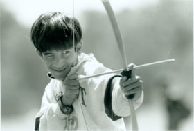
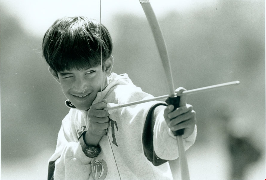
Aadam Tejpar
https://search.heritageburnaby.ca/link/archivedescription79375
- Repository
- City of Burnaby Archives
- Date
- July 24, 1996
- Collection/Fonds
- Burnaby NewsLeader photograph collection
- Description Level
- Item
- Physical Description
- 1 photograph : b&w ; 16 x 23 cm
- Scope and Content
- Photograph of Aadam Tejpar, 8, practicing his shot with a bow and arrow at Simon Fraser University's 'mini university' day camp.
- Repository
- City of Burnaby Archives
- Date
- July 24, 1996
- Collection/Fonds
- Burnaby NewsLeader photograph collection
- Physical Description
- 1 photograph : b&w ; 16 x 23 cm
- Description Level
- Item
- Record No.
- 535-0357
- Access Restriction
- No restrictions
- Reproduction Restriction
- No reproduction permitted
- Accession Number
- 2012-11
- Scope and Content
- Photograph of Aadam Tejpar, 8, practicing his shot with a bow and arrow at Simon Fraser University's 'mini university' day camp.
- Subjects
- Recreational Activities
- Media Type
- Photograph
- Photographer
- Bartel, Mario
- Notes
- Title based on contents of photograph
- Note in black ink on recto of photograph reads: "Bartel Bby 1893 / Bby 3 85%"
- Trim marks and/or reproduction instructions on recto (scan is cropped)
Images
![Aaron Lau throwing a javelin, [1999] thumbnail](/media/hpo/_Data/_Archives_Images/_Unrestricted/535/535-3160.jpg?width=280)
Aaron Lau throwing a javelin
https://search.heritageburnaby.ca/link/archivedescription98080
- Repository
- City of Burnaby Archives
- Date
- [1999]
- Collection/Fonds
- Burnaby NewsLeader photograph collection
- Description Level
- Item
- Physical Description
- 1 photograph (tiff) : col.
- Scope and Content
- Photograph of Aaron Lau, a Moscrop Secondary School student, about to throw a javelin during a Burnaby-New Westminster high school track and field meet at Burnaby Central.
- Repository
- City of Burnaby Archives
- Date
- [1999]
- Collection/Fonds
- Burnaby NewsLeader photograph collection
- Physical Description
- 1 photograph (tiff) : col.
- Description Level
- Item
- Record No.
- 535-3160
- Access Restriction
- No restrictions
- Reproduction Restriction
- No restrictions
- Accession Number
- 2018-12
- Scope and Content
- Photograph of Aaron Lau, a Moscrop Secondary School student, about to throw a javelin during a Burnaby-New Westminster high school track and field meet at Burnaby Central.
- Subjects
- Sports
- Persons - Students
- Media Type
- Photograph
- Notes
- Title based on caption
- Collected by editorial for use in a May 1999 issue of the Burnaby NewsLeader
- Caption from metadata: "Moscrop's Aaron Lau rears back in the boys' javelin competition at the Burnaby-New West high school track and field meet at Burnaby Central."
- Geographic Access
- Canada Way
- Street Address
- 4939 Canada Way
- Historic Neighbourhood
- Burnaby Lake (Historic Neighbourhood)
- Planning Study Area
- Douglas-Gilpin Area
Images
![Aaron Lau throwing a javelin, [1999] thumbnail](/media/hpo/_Data/_Archives_Images/_Unrestricted/535/535-3160.jpg)