Narrow Results By
Subject
- Agricultural Tools and Equipment 1
- Agriculture - Farms 4
- Animals - Cats 1
- Animals - Cows 1
- Buildings - Agricultural - Barns 1
- Buildings - Industrial - Dairies 2
- Buildings - Industrial - Mills 3
- Buildings - Residential - Houses 3
- Buildings - Schools 1
- Construction 1
- Documentary Artifacts - Portraits 1
- Geographic Features - Rivers 3
Person / Organization
- Bearn, William "Bill" 1
- Bearn, William "Bud" 1
- Christianson, Audrey Frances May Bearn 1
- Comberbach, Gladys Phillips 1
- Haddock, Doris Edna Bearn 1
- J.E. Phillips Victory Dairy 3
- Law, Gladys Evangeline Bearn 1
- McGregor, Jean Phyllis 1
- North Arm Dairy 1
- Phillips, Freda 1
- Phillips, Lawerne 1
- Phillips, Marjorie 1

BCER Connaught Cut-off
https://search.heritageburnaby.ca/link/landmark774
- Repository
- Burnaby Heritage Planning
- Associated Dates
- 1912
- Heritage Value
- The BCER Connaught Cut-off was named after the Duke of Connaught, who visited Burnaby in 1912. The original route of the interurban tramline was built along 12th Street into New Westminister, which proved to be too steep of a route, with many accidents occuring due to the grade. The Connaught Cut-Off was built in 1912 to re-route the interurban tram to the south of its original route from Highland Park Station, avoiding the steep hill on 12th Street. Streetcar service was introduced on the now abandonned track on 12th Street, connecting to the Highland Park Station. This streetcar route was known as the Highland Park Streetcar.
- Historic Neighbourhood
- Burnaby Lake (Historic Neighbourhood)
- Planning Study Area
- Big Bend Area
Images


Fraser Arm Neighbourhood
https://search.heritageburnaby.ca/link/landmark708
- Repository
- Burnaby Heritage Planning
- Associated Dates
- 1925-1954
- Heritage Value
- By the late 1920s, the Fraser Arm Neighbourhood in Burnaby was developing into an industrial and manufacturing district. In 1931, the Canadian National Railway built a bridge over the Fraser River from Burnaby to Lulu Island and advertised that over 30 industries were currently operating along the North Fraser. Along with industries, this district remained an important agricultural area for the Lower Mainland. Chinese market gardens continued to develop and thrive and in 1926, the Vancouver Sun estimated that that Chinese farms in the Lower Fraser Valley then supplied 90 per cent of all green vegetables consumed in the Vancouver market area.
- Historic Neighbourhood
- Fraser Arm (Historic Neighbourhood)
- Planning Study Area
- Big Bend Area
Images


Fraser Arm Neighbourhood
https://search.heritageburnaby.ca/link/landmark767
- Repository
- Burnaby Heritage Planning
- Associated Dates
- 1905-1924
- Heritage Value
- Fraser Arm - so named because there the tram crossed Gilley Avenue, running down to the North Arm of the Fraser River - was served by the River Road [Marine Drive] which traversed the municipality of Burnaby, leading to both New Westminster and Vancouver. This area did not experience a real estate boom during the 1909-1913 as did many other Burnaby neighbourhoods - in fact, by 1912, only three homes had been built along Riverway as it remained a predominantly agricultural area.
- Historic Neighbourhood
- Fraser Arm (Historic Neighbourhood)
- Planning Study Area
- Big Bend Area
Images


Johnson & Mary Skinner Residence
https://search.heritageburnaby.ca/link/landmark551
- Repository
- Burnaby Heritage Planning
- Description
- Residential building.
- Associated Dates
- c.1912
- Other Names
- Timms House
- Street View URL
- Google Maps Street View
- Repository
- Burnaby Heritage Planning
- Other Names
- Timms House
- Geographic Access
- Marine Drive
- Associated Dates
- c.1912
- Description
- Residential building.
- Heritage Value
- This house was originally built by Fraser Arm pioneer and postmaster Johnson Alfred Skinner (1864-1941) and his wife, Mary Emma Skinner (née Bailey, 1862-1929). Johnson, who was from Sussex, worked as a horticulturalist. This is an unusual variation on the Craftsman style, with a side gabled roof and a half-width front verandah. Local mason John Pickard completed the distinctive battered cobblestone masonry, including the foundation, chimney, verandah columns and the porte-cochère. The house was later occupied and remodeled by the Timms family.
- Locality
- Fraser Arm
- Historic Neighbourhood
- Fraser Arm (Historic Neighbourhood)
- Planning Study Area
- Big Bend Area
- Ownership
- Private
- Street Address
- 5634 Marine Drive
- Street View URL
- Google Maps Street View
Images


Riverway West School
https://search.heritageburnaby.ca/link/landmark768
- Repository
- Burnaby Heritage Planning
- Geographic Access
- Marine Drive
- Associated Dates
- 1922
- Heritage Value
- Riverway West School was built on a slope just north of Riverway Road (Marine Drive). From 1922 until 1952, the school operated as a one-teacher school. In 1962, the original building was replaced with a larger structure but declining school enrolments in Burnaby during the 1970s brought about Riverway's closure in the early 1980s.
- Historic Neighbourhood
- Fraser Arm (Historic Neighbourhood)
- Planning Study Area
- Big Bend Area
- Street Address
- 4340 Marine Drive
- Street View URL
- Google Maps Street View
Images

Bearn family
https://search.heritageburnaby.ca/link/archivedescription37072
- Repository
- City of Burnaby Archives
- Date
- 1923 (date of original), copied 1992
- Collection/Fonds
- Burnaby Historical Society fonds
- Description Level
- Item
- Physical Description
- 1 photograph : b&w ; 6.9 x 12.3 cm print
- Scope and Content
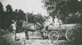
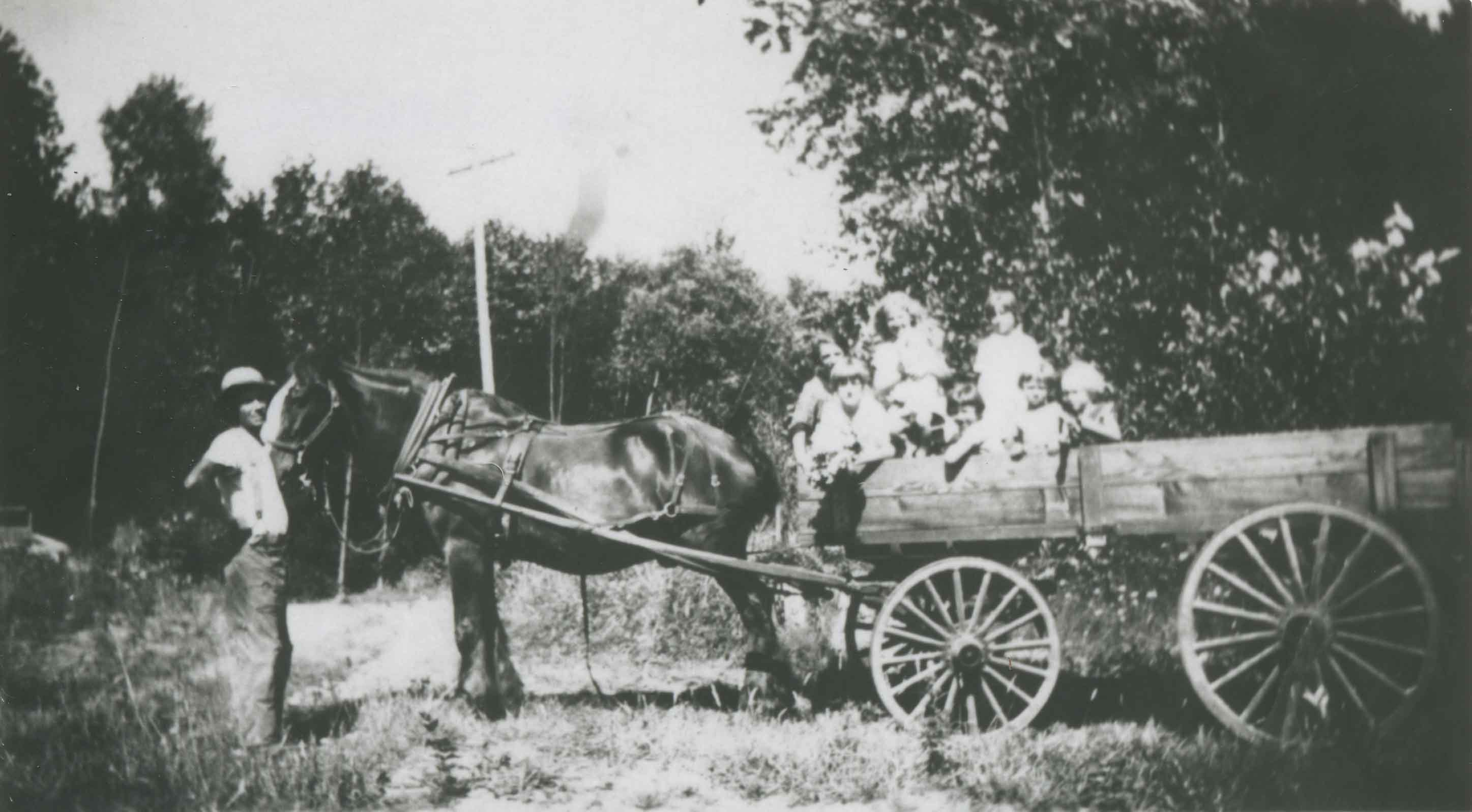
- Photograph of William "Bill" Bearn taking his children for wagon ride on Marine Drive. There were eight Bearn children: Ruth, Gladys, Doris, Helen, Jean, Audrey, William "Bud," and Shirley.
- Repository
- City of Burnaby Archives
- Date
- 1923 (date of original), copied 1992
- Collection/Fonds
- Burnaby Historical Society fonds
- Subseries
- Burnaby Centennial Anthology subseries
- Physical Description
- 1 photograph : b&w ; 6.9 x 12.3 cm print
- Description Level
- Item
- Record No.
- 315-535
- Access Restriction
- No restrictions
- Reproduction Restriction
- No known restrictions
- Accession Number
- BHS1994-04
- Scope and Content
- Photograph of William "Bill" Bearn taking his children for wagon ride on Marine Drive. There were eight Bearn children: Ruth, Gladys, Doris, Helen, Jean, Audrey, William "Bud," and Shirley.
- Names
- Christianson, Audrey Frances May Bearn
- Haddock, Doris Edna Bearn
- Law, Gladys Evangeline Bearn
- Solloway, Helen Beryl Bearn
- McGregor, Jean Phyllis
- Taylor, Shirley Bearn
- Bearn, William "Bill"
- Bearn, William "Bud"
- Whittacker, Ruth Bearn
- Media Type
- Photograph
- Notes
- Title based on contents of photograph
- Geographic Access
- Marine Drive
- Historic Neighbourhood
- Fraser Arm (Historic Neighbourhood)
- Planning Study Area
- Big Bend Area
Images

Bearn sisters
https://search.heritageburnaby.ca/link/archivedescription37076
- Repository
- City of Burnaby Archives
- Date
- 1926 (date of original), copied 1992
- Collection/Fonds
- Burnaby Historical Society fonds
- Description Level
- Item
- Physical Description
- 1 photograph : b&w ; 7.1 x 11.8 cm print
- Scope and Content
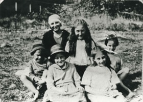
- Photograph of three of the daughters of William "Bill" and Lavinia Bearn in their mother's flower garden. Mrs. Bearn sold the flowers in her flower shop. Two of the girls are holding cats. There were seven daughters: Ruth, Gladys, Doris, Helen, Jean, Audrey, and Shirley.
- Repository
- City of Burnaby Archives
- Date
- 1926 (date of original), copied 1992
- Collection/Fonds
- Burnaby Historical Society fonds
- Subseries
- Burnaby Centennial Anthology subseries
- Physical Description
- 1 photograph : b&w ; 7.1 x 11.8 cm print
- Description Level
- Item
- Record No.
- 315-539
- Access Restriction
- No restrictions
- Reproduction Restriction
- No known restrictions
- Accession Number
- BHS1994-04
- Scope and Content
- Photograph of three of the daughters of William "Bill" and Lavinia Bearn in their mother's flower garden. Mrs. Bearn sold the flowers in her flower shop. Two of the girls are holding cats. There were seven daughters: Ruth, Gladys, Doris, Helen, Jean, Audrey, and Shirley.
- Subjects
- Animals - Cats
- Plants - Flowers
- Media Type
- Photograph
- Notes
- Title based on contents of photograph
- Geographic Access
- Marine Drive
- Boundary Road
- Historic Neighbourhood
- Fraser Arm (Historic Neighbourhood)
- Planning Study Area
- Big Bend Area
Images

![Boy standing at the fence, [1920] (date of original), copied 1986 thumbnail](/media/hpo/_Data/_Archives_Images/_Unrestricted/126/162-010.jpg?width=280)
Boy standing at the fence
https://search.heritageburnaby.ca/link/archivedescription34941
- Repository
- City of Burnaby Archives
- Date
- [1920] (date of original), copied 1986
- Collection/Fonds
- Burnaby Historical Society fonds
- Description Level
- Item
- Physical Description
- 1 photograph : b&w ; 12.5 x 8.8 cm print
- Scope and Content
- Photograph of a boy standing at a white picket fence holding onto a wheelbarrow alongside Marine Drive. The Unident house can be seen in the background.
- Repository
- City of Burnaby Archives
- Date
- [1920] (date of original), copied 1986
- Collection/Fonds
- Burnaby Historical Society fonds
- Subseries
- Photographs subseries
- Physical Description
- 1 photograph : b&w ; 12.5 x 8.8 cm print
- Description Level
- Item
- Record No.
- 162-010
- Access Restriction
- No restrictions
- Reproduction Restriction
- No known restrictions
- Accession Number
- BHS1986-13
- Scope and Content
- Photograph of a boy standing at a white picket fence holding onto a wheelbarrow alongside Marine Drive. The Unident house can be seen in the background.
- Media Type
- Photograph
- Notes
- Title based on contents of photograph
- Geographic Access
- Marine Drive
- Historic Neighbourhood
- Fraser Arm (Historic Neighbourhood)
- Planning Study Area
- Big Bend Area
Images
![Boy standing at the fence, [1920] (date of original), copied 1986 thumbnail](/media/hpo/_Data/_Archives_Images/_Unrestricted/126/162-010.jpg)
![Ethel Thrussell, [1914] thumbnail](/media/hpo/_Data/_Archives_Images/_Unrestricted/251/275-008.jpg?width=280)
Ethel Thrussell
https://search.heritageburnaby.ca/link/archivedescription36476
- Repository
- City of Burnaby Archives
- Date
- [1914]
- Collection/Fonds
- Burnaby Historical Society fonds
- Description Level
- Item
- Physical Description
- 1 photograph : b&w ; 8.5 x 12.5 cm print
- Scope and Content
- Photograph of Ethel Thrussell, one of Frederick and Harriett Fenwick Thrussell's children, at the gate of the Thrussell family home.
- Repository
- City of Burnaby Archives
- Date
- [1914]
- Collection/Fonds
- Burnaby Historical Society fonds
- Subseries
- Thrussell family subseries
- Physical Description
- 1 photograph : b&w ; 8.5 x 12.5 cm print
- Description Level
- Item
- Record No.
- 275-008
- Access Restriction
- No restrictions
- Reproduction Restriction
- No known restrictions
- Accession Number
- BHS1992-05
- Scope and Content
- Photograph of Ethel Thrussell, one of Frederick and Harriett Fenwick Thrussell's children, at the gate of the Thrussell family home.
- Subjects
- Structures - Fences
- Names
- Thrussell, Ethel
- Media Type
- Photograph
- Notes
- Title based on contents of photograph
- Geographic Access
- Marine Drive
- Nelson Avenue
- Historic Neighbourhood
- Fraser Arm (Historic Neighbourhood)
- Planning Study Area
- Big Bend Area
Images
![Ethel Thrussell, [1914] thumbnail](/media/hpo/_Data/_Archives_Images/_Unrestricted/251/275-008.jpg)
Fraser Arm District
https://search.heritageburnaby.ca/link/archivedescription37139
- Repository
- City of Burnaby Archives
- Date
- [between 1911 and 1919]
- Collection/Fonds
- Burnaby Historical Society fonds
- Description Level
- Item
- Physical Description
- 1 photograph : b&w ; 8 x 12.5 cm print
- Scope and Content
- Photograph of the Fraser Arm District, taken from Marine Drive.
- Repository
- City of Burnaby Archives
- Date
- [between 1911 and 1919]
- Collection/Fonds
- Burnaby Historical Society fonds
- Subseries
- Disney family subseries
- Physical Description
- 1 photograph : b&w ; 8 x 12.5 cm print
- Description Level
- Item
- Record No.
- 325-011
- Access Restriction
- No restrictions
- Reproduction Restriction
- No known restrictions
- Accession Number
- BHS1996-04
- Scope and Content
- Photograph of the Fraser Arm District, taken from Marine Drive.
- Media Type
- Photograph
- Photographer
- Disney, John Harold "Jack"
- Notes
- Title based on contents of photograph
- Historic Neighbourhood
- Fraser Arm (Historic Neighbourhood)
- Planning Study Area
- Big Bend Area
Images
Fraser River
https://search.heritageburnaby.ca/link/archivedescription37077
- Repository
- City of Burnaby Archives
- Date
- 1920 (date of original), copied 1992
- Collection/Fonds
- Burnaby Historical Society fonds
- Description Level
- Item
- Physical Description
- 1 photograph : b&w ; 7.1 x 12.3 cm print
- Scope and Content
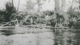
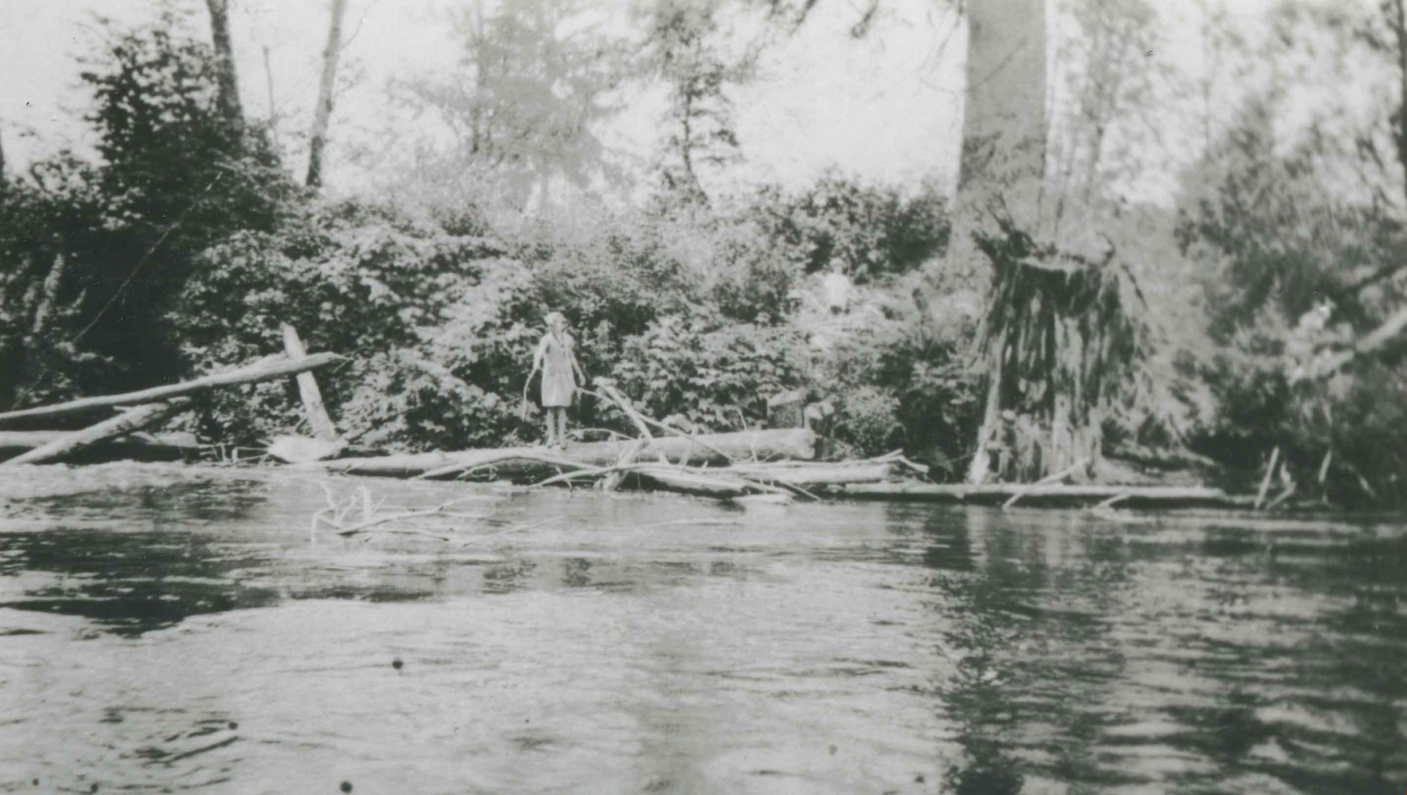
- Photograph of the Fraser River shore. A woman can be seen standing on a log on the river's edge.
- Repository
- City of Burnaby Archives
- Date
- 1920 (date of original), copied 1992
- Collection/Fonds
- Burnaby Historical Society fonds
- Subseries
- Burnaby Centennial Anthology subseries
- Physical Description
- 1 photograph : b&w ; 7.1 x 12.3 cm print
- Description Level
- Item
- Record No.
- 315-540
- Access Restriction
- No restrictions
- Reproduction Restriction
- No known restrictions
- Accession Number
- BHS1994-04
- Scope and Content
- Photograph of the Fraser River shore. A woman can be seen standing on a log on the river's edge.
- Subjects
- Geographic Features - Rivers
- Media Type
- Photograph
- Notes
- Title based on contents of photograph
- Historic Neighbourhood
- Fraser Arm (Historic Neighbourhood)
- Planning Study Area
- Big Bend Area
Images
![Freda Phillips, [192-] (date of original), copied 1986 thumbnail](/media/hpo/_Data/_Archives_Images/_Unrestricted/204/204-514.jpg?width=280)
Freda Phillips
https://search.heritageburnaby.ca/link/archivedescription35656
- Repository
- City of Burnaby Archives
- Date
- [192-] (date of original), copied 1986
- Collection/Fonds
- Burnaby Historical Society fonds
- Description Level
- Item
- Physical Description
- 1 photograph : b&w ; 12.7 x 17.8 cm print
- Scope and Content
- Photograph of Freda Phillips (youngest sister of Gladys Phillips Comberbach) and an unidentified friend working on the farm leased by the Phillips family at 515 Byrne Road (later renumbered 5670 Byrne Road).
- Repository
- City of Burnaby Archives
- Date
- [192-] (date of original), copied 1986
- Collection/Fonds
- Burnaby Historical Society fonds
- Subseries
- Pioneer Tales subseries
- Physical Description
- 1 photograph : b&w ; 12.7 x 17.8 cm print
- Description Level
- Item
- Record No.
- 204-514
- Access Restriction
- No restrictions
- Reproduction Restriction
- No known restrictions
- Accession Number
- BHS1988-03
- Scope and Content
- Photograph of Freda Phillips (youngest sister of Gladys Phillips Comberbach) and an unidentified friend working on the farm leased by the Phillips family at 515 Byrne Road (later renumbered 5670 Byrne Road).
- Names
- Phillips, Freda
- Media Type
- Photograph
- Notes
- Title based on contents of photograph
- Geographic Access
- Byrne Road
- Street Address
- 5670 Byrne Road
- Historic Neighbourhood
- Fraser Arm (Historic Neighbourhood)
- Planning Study Area
- Big Bend Area
Images
![Freda Phillips, [192-] (date of original), copied 1986 thumbnail](/media/hpo/_Data/_Archives_Images/_Unrestricted/204/204-514.jpg)
![J.E. Phillips Victory Dairy Truck, [192-] (date of original), copied 1986 thumbnail](/media/hpo/_Data/_Archives_Images/_Unrestricted/204/204-513.jpg?width=280)
J.E. Phillips Victory Dairy Truck
https://search.heritageburnaby.ca/link/archivedescription35655
- Repository
- City of Burnaby Archives
- Date
- [192-] (date of original), copied 1986
- Collection/Fonds
- Burnaby Historical Society fonds
- Description Level
- Item
- Physical Description
- 1 photograph : b&w ; 12.7 x 17.8 cm print
- Scope and Content
- Photograph of a J.E. Phillips Victory Dairy truck. The dairy was started by Mrs. Lily Phillips. The trucks replaced the horse and wagon used to deliver milk. Prior to the horse and wagon, the Phillips girls used a hand-drawn wagon for deliveries. The dairy was located at 515 Byrne Road (later r…
- Repository
- City of Burnaby Archives
- Date
- [192-] (date of original), copied 1986
- Collection/Fonds
- Burnaby Historical Society fonds
- Subseries
- Pioneer Tales subseries
- Physical Description
- 1 photograph : b&w ; 12.7 x 17.8 cm print
- Description Level
- Item
- Record No.
- 204-513
- Access Restriction
- No restrictions
- Reproduction Restriction
- No known restrictions
- Accession Number
- BHS1988-03
- Scope and Content
- Photograph of a J.E. Phillips Victory Dairy truck. The dairy was started by Mrs. Lily Phillips. The trucks replaced the horse and wagon used to deliver milk. Prior to the horse and wagon, the Phillips girls used a hand-drawn wagon for deliveries. The dairy was located at 515 Byrne Road (later renumbered 5670 Byrne Road).
- Subjects
- Transportation - Trucks
- Media Type
- Photograph
- Notes
- Title based on contents of photograph
- Geographic Access
- Byrne Road
- Street Address
- 5670 Byrne Road
- Historic Neighbourhood
- Fraser Arm (Historic Neighbourhood)
- Planning Study Area
- Big Bend Area
Images
![J.E. Phillips Victory Dairy Truck, [192-] (date of original), copied 1986 thumbnail](/media/hpo/_Data/_Archives_Images/_Unrestricted/204/204-513.jpg)
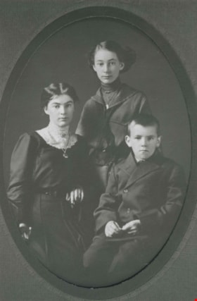
Mary Anne, Ethel, and Fred
https://search.heritageburnaby.ca/link/archivedescription36481
- Repository
- City of Burnaby Archives
- Date
- 1913
- Collection/Fonds
- Burnaby Historical Society fonds
- Description Level
- Item
- Physical Description
- 1 photograph : b&w ; 11.5 x 7.5 cm oval, print
- Scope and Content
- Photograph of Mary Anne, Ethel, and Frederick T., three of Frederick and Harriett Thrussell's children, taken in a photographic studio in New Westminster.
- Repository
- City of Burnaby Archives
- Date
- 1913
- Collection/Fonds
- Burnaby Historical Society fonds
- Subseries
- Thrussell family subseries
- Physical Description
- 1 photograph : b&w ; 11.5 x 7.5 cm oval, print
- Description Level
- Item
- Record No.
- 275-013
- Access Restriction
- No restrictions
- Reproduction Restriction
- No known restrictions
- Accession Number
- BHS1992-05
- Scope and Content
- Photograph of Mary Anne, Ethel, and Frederick T., three of Frederick and Harriett Thrussell's children, taken in a photographic studio in New Westminster.
- Subjects
- Documentary Artifacts - Portraits
- Names
- Welsh, Mary Anne "Annie" Thrussell Phillips
- Thrussell, Ethel
- Thrussell, Fredrick Thomas (1901-1977)
- Media Type
- Photograph
- Notes
- Title based on contents of photograph
- Original photograph was housed in an oval mat
- Original mat had a stamp on its recto which read: "Ritchie / New Westminister"
- Historic Neighbourhood
- Fraser Arm (Historic Neighbourhood)
- Planning Study Area
- Big Bend Area
Images

![Phillips Dairy Farm, [192-] (date of original), copied 1986 thumbnail](/media/hpo/_Data/_Archives_Images/_Unrestricted/204/204-515.jpg?width=280)
Phillips Dairy Farm
https://search.heritageburnaby.ca/link/archivedescription35657
- Repository
- City of Burnaby Archives
- Date
- [192-] (date of original), copied 1986
- Collection/Fonds
- Burnaby Historical Society fonds
- Description Level
- Item
- Physical Description
- 1 photograph : b&w ; 12.7 x 17.8 cm print
- Scope and Content
- Photograph of dairy cows on the Phillips farm leased by the family. The farm covered 500 acres at the foot of Byrne Road near Mandeville in the Big Bend area of South Burnaby.
- Repository
- City of Burnaby Archives
- Date
- [192-] (date of original), copied 1986
- Collection/Fonds
- Burnaby Historical Society fonds
- Subseries
- Pioneer Tales subseries
- Physical Description
- 1 photograph : b&w ; 12.7 x 17.8 cm print
- Description Level
- Item
- Record No.
- 204-515
- Access Restriction
- No restrictions
- Reproduction Restriction
- No known restrictions
- Accession Number
- BHS1988-03
- Scope and Content
- Photograph of dairy cows on the Phillips farm leased by the family. The farm covered 500 acres at the foot of Byrne Road near Mandeville in the Big Bend area of South Burnaby.
- Subjects
- Animals - Cows
- Agriculture - Farms
- Media Type
- Photograph
- Notes
- Title based on contents of photograph
- Pioneer Tales describes the amount of land leased as 100 acres
- Geographic Access
- Byrne Road
- Street Address
- 5670 Byrne Road
- Historic Neighbourhood
- Fraser Arm (Historic Neighbourhood)
- Planning Study Area
- Big Bend Area
Images
![Phillips Dairy Farm, [192-] (date of original), copied 1986 thumbnail](/media/hpo/_Data/_Archives_Images/_Unrestricted/204/204-515.jpg)
![Phillips Dairy Farm, [192-] (date of original), copied 1986 thumbnail](/media/hpo/_Data/_Archives_Images/_Unrestricted/204/204-519.jpg?width=280)
Phillips Dairy Farm
https://search.heritageburnaby.ca/link/archivedescription35661
- Repository
- City of Burnaby Archives
- Date
- [192-] (date of original), copied 1986
- Collection/Fonds
- Burnaby Historical Society fonds
- Description Level
- Item
- Physical Description
- 1 photograph : b&w ; 12.7 x 17.8 cm print
- Scope and Content
- Photograph of Phillips dairy farm at 515 Byrne Road (later renumbered 5670 Byrne Road). The dairy and barn are shown with Norman Phillips (son of John and Lily Phillips).
- Repository
- City of Burnaby Archives
- Date
- [192-] (date of original), copied 1986
- Collection/Fonds
- Burnaby Historical Society fonds
- Subseries
- Pioneer Tales subseries
- Physical Description
- 1 photograph : b&w ; 12.7 x 17.8 cm print
- Description Level
- Item
- Record No.
- 204-519
- Access Restriction
- No restrictions
- Reproduction Restriction
- No known restrictions
- Accession Number
- BHS1988-03
- Scope and Content
- Photograph of Phillips dairy farm at 515 Byrne Road (later renumbered 5670 Byrne Road). The dairy and barn are shown with Norman Phillips (son of John and Lily Phillips).
- Media Type
- Photograph
- Notes
- Title based on contents of photograph
- Geographic Access
- Byrne Road
- Street Address
- 5670 Byrne Road
- Historic Neighbourhood
- Fraser Arm (Historic Neighbourhood)
- Planning Study Area
- Big Bend Area
Images
![Phillips Dairy Farm, [192-] (date of original), copied 1986 thumbnail](/media/hpo/_Data/_Archives_Images/_Unrestricted/204/204-519.jpg)
Phillips family
https://search.heritageburnaby.ca/link/archivedescription35460
- Repository
- City of Burnaby Archives
- Date
- 1919 (date of original), copied 1986
- Collection/Fonds
- Burnaby Historical Society fonds
- Description Level
- Item
- Physical Description
- 1 photograph : b&w ; 12.7 x 17.8 cm print
- Scope and Content
- Photograph of the Phillips family. Back row, left to right: Gladys Phillips (sister, later Gladys Comberbach), Marjorie Phillips (sister), and Christine Royal (neighbour). Front row, left to right: Norman Phillips (brother), Bessie Warne (cousin), and Muriel Phillips (sister). The Phillips' were th…
- Repository
- City of Burnaby Archives
- Date
- 1919 (date of original), copied 1986
- Collection/Fonds
- Burnaby Historical Society fonds
- Subseries
- Pioneer Tales subseries
- Physical Description
- 1 photograph : b&w ; 12.7 x 17.8 cm print
- Description Level
- Item
- Record No.
- 204-318
- Access Restriction
- No restrictions
- Reproduction Restriction
- No known restrictions
- Accession Number
- BHS1988-03
- Scope and Content
- Photograph of the Phillips family. Back row, left to right: Gladys Phillips (sister, later Gladys Comberbach), Marjorie Phillips (sister), and Christine Royal (neighbour). Front row, left to right: Norman Phillips (brother), Bessie Warne (cousin), and Muriel Phillips (sister). The Phillips' were the children of John Phillips and Lily Phillips (nee Warne), who owned and operated a dairy farm in South Burnaby. This photograph was taken near their 5670 Byrne Road farm and home.
- Names
- Comberbach, Gladys Phillips
- Phillips, Marjorie
- Phillips, Muriel
- Phillips, Norman
- Royal, Christine
- Warne, Bessie
- Media Type
- Photograph
- Notes
- Title based on contents of photograph
- Geographic Access
- Byrne Road
- Street Address
- 5670 Byrne Road
- Historic Neighbourhood
- Fraser Arm (Historic Neighbourhood)
- Planning Study Area
- Big Bend Area
Images

Phillips family home
https://search.heritageburnaby.ca/link/archivedescription35461
- Repository
- City of Burnaby Archives
- Date
- 1929 (date of original), copied 1986
- Collection/Fonds
- Burnaby Historical Society fonds
- Description Level
- Item
- Physical Description
- 1 photograph : b&w ; 12.7 x 17.8 cm print
- Scope and Content
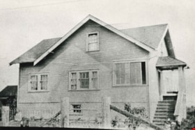
- Photograph of the Phillips family home at 5670 Byrne Road, built in 1929. This was the home of John Phillips, his wife Lily Phillips (nee Warne) and their children. They owned and operated a large dairy (Victory Dairy). The dairy and cow barns were also on this property.
- Repository
- City of Burnaby Archives
- Date
- 1929 (date of original), copied 1986
- Collection/Fonds
- Burnaby Historical Society fonds
- Subseries
- Pioneer Tales subseries
- Physical Description
- 1 photograph : b&w ; 12.7 x 17.8 cm print
- Description Level
- Item
- Record No.
- 204-319
- Access Restriction
- No restrictions
- Reproduction Restriction
- No known restrictions
- Accession Number
- BHS1988-03
- Scope and Content
- Photograph of the Phillips family home at 5670 Byrne Road, built in 1929. This was the home of John Phillips, his wife Lily Phillips (nee Warne) and their children. They owned and operated a large dairy (Victory Dairy). The dairy and cow barns were also on this property.
- Subjects
- Buildings - Residential - Houses
- Media Type
- Photograph
- Notes
- Title based on contents of photograph
- Geographic Access
- Byrne Road
- Street Address
- 5670 Byrne Road
- Historic Neighbourhood
- Fraser Arm (Historic Neighbourhood)
- Planning Study Area
- Big Bend Area
Images

Riverway East and Riverway West Schools
https://search.heritageburnaby.ca/link/archivedescription87921
- Repository
- City of Burnaby Archives
- Date
- 1926-1967 (date of originals), copied [1990]
- Collection/Fonds
- Mary Forsyth fonds
- Description Level
- File
- Physical Description
- 24 photographs : b&w copy prints + 25 photographs : b&w negatives ; 35 mm
- Scope and Content
- Photographs of Dundonald, Riverway East, Glenwood and Riverway West schools and negatives.
- Repository
- City of Burnaby Archives
- Date
- 1926-1967 (date of originals), copied [1990]
- Collection/Fonds
- Mary Forsyth fonds
- Physical Description
- 24 photographs : b&w copy prints + 25 photographs : b&w negatives ; 35 mm
- Description Level
- File
- Record No.
- 572-002
- Access Restriction
- In Archives only
- Reproduction Restriction
- No reproduction permitted
- Accession Number
- 2014-27
- Scope and Content
- Photographs of Dundonald, Riverway East, Glenwood and Riverway West schools and negatives.
- Subjects
- Buildings - Schools
- Names
- Riverway East School
- Media Type
- Photograph
- Notes
- Title based on contents of photograph
- Most of the photographs are copy prints taken from the Riverway West PTA scrapbook MSS068-001 (Bay 64 - Shelf 6)
- Many of the photographs contain annotations on verso
- Note in pencil on verso of photograph 572-002-1 reads: "Riverway East"
- Note in pencil on verso of photograph 572-002-2 reads: "school site for/ 1) Dundonald with shed/ 2) Riverway East 1905/ 3) Glenwood"
- Note in blue pen on verso of photograph 572-002-38 reads:"back row/ Miss Kidd, Donald Kin, William Waldner, Sammy Gilbert, Lucy Checkowsky, Geraldine McIntyre, Beatrice MacGowen, Jean Banon, Dorren McClure, Sady Mann, Sonny McClure, 2 Normal Students/2nd row/Eva Eng, Florence MacGowen, Evelyn Rorison, Kay Rorison, Nelie Wilson, Jessie Gilbert, Margaret Corothers, Audrey Banon, Betty Mann, Jean MacMullin/3rd row/ Hughie Rorison, Engine Banoff, David Downs, Donald McIntyre, Fred Chambers, George Eng, Anthony Checkowsky, Jimmy Wintson, Art McClure, Leonard Geall, Jack Rorison, Peter Smith, Gum Eng."
- Historic Neighbourhood
- Fraser Arm (Historic Neighbourhood)
- Planning Study Area
- Big Bend Area
Rorison family
https://search.heritageburnaby.ca/link/archivedescription87857
- Repository
- City of Burnaby Archives
- Date
- Between 1926 and 1940 (date of originals), copied [1990]
- Collection/Fonds
- Mary Forsyth fonds
- Description Level
- File
- Physical Description
- 6 photographs : b&w copy prints ; 10 x 15 cm
- Scope and Content
- Photographs of the Cropley and Rorison families near their home located at 3907 River Road (now Marine Drive) in Burnaby. The property was purchased by Matilda Cropley in 1913. Matilda married Alfred Cropley and may have lived on the property. Matilda and Alfred's daughter, Alma married William Ror…
- Repository
- City of Burnaby Archives
- Date
- Between 1926 and 1940 (date of originals), copied [1990]
- Collection/Fonds
- Mary Forsyth fonds
- Physical Description
- 6 photographs : b&w copy prints ; 10 x 15 cm
- Description Level
- File
- Record No.
- 572-001
- Access Restriction
- In Archives only
- Reproduction Restriction
- No reproduction permitted
- Accession Number
- 2014-27
- Scope and Content
- Photographs of the Cropley and Rorison families near their home located at 3907 River Road (now Marine Drive) in Burnaby. The property was purchased by Matilda Cropley in 1913. Matilda married Alfred Cropley and may have lived on the property. Matilda and Alfred's daughter, Alma married William Rorison and built their home on part of the land owned by Matilda. Alma and William had four children, Bill (William Jr.), Hugh and twin girls Kay (Kathleen) and Evelyn.
- Names
- Rorison, Marguerite
- Media Type
- Photograph
- Notes
- Title based on contents of photograph
- Date of originals noted on verso of copy print
- Captions on verso describe the photographs and identify individuals
- Historic Neighbourhood
- Fraser Arm (Historic Neighbourhood)
- Planning Study Area
- Big Bend Area