Narrow Results By
Subject
- Buildings - Heritage 5
- Buildings - Religious - Churches 12
- Buildings - Residential - Houses 5
- Buildings - Schools 16
- Businesses - Real Estate Agencies 1
- Documentary Artifacts - Certificates 8
- Exhibitions 1
- First Nations reserves - British Columbia 1
- Government - Federal Government 1
- Government - Provincial Government 1
- Migration 2
- Organizations - Boys' Societies and Clubs 2
Creator
- British Columbia Underwriters' Association 2
- Burnett and McGugan B.C. Land Surveyors, New Westminster 5
- Burnett, Geoffrey K. 5
- Burnett & McGugan, Engineers and Surveyors 22
- Coast Map and Blue Print Co. 1
- Corporation of the District of Burnaby 1
- Dominion Map and Blueprint Co. 1
- Geoffrey K. Burnett 1
- Government of Canada 3
- Hill & Burnett 4
- Leibly & Blumer Realty Co. Incorporated 1
- McGugan, Donald Johnston 9
Person / Organization
- All Saints Anglican Church 2
- Armstrong Avenue School 1
- Barnet School 1
- Boy Scouts of Canada 2
- Broadview Presbyterian Church 1
- Burnett, Geoffrey K. 2
- Co-operative Commonwealth Federation "CCF" 1
- Douglas Road School 1
- Douglas, Tommy 1
- Dundonald United Church 1
- East Burnaby United Church, 1925-2008 1
- Edmonds Community School 2
![All Saints Church, [ca.1910] thumbnail](/media/hpo/_Data/_BVM_Cartographic_Material/2003/2003_0083_0046_001.jpg?width=280)
All Saints Church
https://search.heritageburnaby.ca/link/museumdescription11924
- Repository
- Burnaby Village Museum
- Date
- [ca.1910]
- Collection/Fonds
- Ronald G. Scobbie collection
- Description Level
- Item
- Physical Description
- 1 plan : black ink and watercol. on paper ; 30.45 x 30.5 cm
- Scope and Content
- Item consists of building insurance plan of "All Saints Church / Lot "A" BK 29 DL 98 GP1 N.W.D.". Watling Street is idenfied to the north of the church building and Royal Oak Avenue to the west.
- Repository
- Burnaby Village Museum
- Collection/Fonds
- Ronald G. Scobbie collection
- Description Level
- Item
- Physical Description
- 1 plan : black ink and watercol. on paper ; 30.45 x 30.5 cm
- Material Details
- Scale 1 inch = 20 feet
- Scope and Content
- Item consists of building insurance plan of "All Saints Church / Lot "A" BK 29 DL 98 GP1 N.W.D.". Watling Street is idenfied to the north of the church building and Royal Oak Avenue to the west.
- Subjects
- Buildings - Religious - Churches
- Accession Code
- BV003.83.46
- Access Restriction
- No restrictions
- Reproduction Restriction
- No known restrictions
- Date
- [ca.1910]
- Media Type
- Cartographic Material
- Scan Resolution
- 600
- Scan Date
- 15-Jan-2021
- Scale
- 100
- Notes
- Transcribed title
- Note in pencil on verso reads: ""All Saints Church / Lot "A" BK 29 DL 98 / Scale 1 inch = 20 feet"
- Note in balck in on verso reads: "3704"
Images
![All Saints Church, [ca.1910] thumbnail](/media/hpo/_Data/_BVM_Cartographic_Material/2003/2003_0083_0046_001.jpg)
![Anglican Church, [ca.1910] thumbnail](/media/hpo/_Data/_BVM_Cartographic_Material/2003/2003_0083_0043_001.jpg?width=280)
Anglican Church
https://search.heritageburnaby.ca/link/museumdescription11921
- Repository
- Burnaby Village Museum
- Date
- [ca.1910]
- Collection/Fonds
- Ronald G. Scobbie collection
- Description Level
- Item
- Physical Description
- 1 plan : black ink and watercol. on paper ; 30.45 x 30.5 cm
- Scope and Content
- Item consists of building insurance plan of "Anglican Church / Lot 2 BK 37 DL69, GP.1, N.W.D. (15th Ave. (Dominion) is identified to the north of Lots 1, 2 and 3).
- Repository
- Burnaby Village Museum
- Collection/Fonds
- Ronald G. Scobbie collection
- Description Level
- Item
- Physical Description
- 1 plan : black ink and watercol. on paper ; 30.45 x 30.5 cm
- Material Details
- Scale 1 inch = 20 feet
- Scope and Content
- Item consists of building insurance plan of "Anglican Church / Lot 2 BK 37 DL69, GP.1, N.W.D. (15th Ave. (Dominion) is identified to the north of Lots 1, 2 and 3).
- Subjects
- Buildings - Religious - Churches
- Accession Code
- BV003.83.43
- Access Restriction
- No restrictions
- Reproduction Restriction
- No known restrictions
- Date
- [ca.1910]
- Media Type
- Cartographic Material
- Scan Resolution
- 600
- Scan Date
- 15-Jan-2021
- Scale
- 100
- Notes
- Transcribed title
- Note in pencil on verso reads: "Anglican Church / Lot 2 Bk 37 DL69 / 1"=20' "
- Note in balck in on verso reads: "3704"
Images
![Anglican Church, [ca.1910] thumbnail](/media/hpo/_Data/_BVM_Cartographic_Material/2003/2003_0083_0043_001.jpg)

Armstrong Street School site
https://search.heritageburnaby.ca/link/museumdescription11133
- Repository
- Burnaby Village Museum
- Date
- 1915
- Collection/Fonds
- Ronald G. Scobbie collection
- Description Level
- Item
- Physical Description
- 1 survey plan : blueprint on paper ; 56 x 54 cm
- Scope and Content
- Survey plan of "Armstrong Street School Site / Burnaby Municipality" "Being a 2 acre portion of Lot 13 Group 1, & according to map 1722 which shows this as Lot E. Block 2 of subdivision of a portion, of Lot 13, Group 1, New Westminster District".
- Repository
- Burnaby Village Museum
- Collection/Fonds
- Ronald G. Scobbie collection
- Description Level
- Item
- Physical Description
- 1 survey plan : blueprint on paper ; 56 x 54 cm
- Material Details
- Scale 40 feet = 1 inch
- Scope and Content
- Survey plan of "Armstrong Street School Site / Burnaby Municipality" "Being a 2 acre portion of Lot 13 Group 1, & according to map 1722 which shows this as Lot E. Block 2 of subdivision of a portion, of Lot 13, Group 1, New Westminster District".
- Creator
- Burnett, Geoffrey K.
- Subjects
- Buildings - Schools
- Names
- Armstrong Avenue School
- Responsibility
- Burnett & McGugan, Engineers and Surveyors
- Geographic Access
- Armstrong Avenue
- Street Address
- 8757 Armstrong Avenue
- Accession Code
- BV003.83.12
- Access Restriction
- No restrictions
- Reproduction Restriction
- No known restrictions
- Date
- 1915
- Media Type
- Cartographic Material
- Historic Neighbourhood
- East Burnaby (Historic Neighbourhood)
- Planning Study Area
- Cariboo-Armstrong Area
- Scan Resolution
- 440
- Scan Date
- 22-Dec-2020
- Scale
- 100
- Notes
- Title based on contents of plan
- Note in black ink on verso of plan reads: "1746"
- Oath on plan reads: "I, Geoffrey K. Burnett...and did personally superintend the survey represented..." "Completed on the 18th day of March 1915"; signed by Geoffrey K. Burnett and notarized by "K.A. Eastman", sworn "...19th day of April 1915"; "Burnett and McGugan., B.C. Land Surveyors. Etc.. New Westminster, B.C.."
Zoomable Images

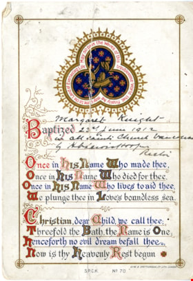
Baptismal certificate for Margaret Knight
https://search.heritageburnaby.ca/link/museumdescription15315
- Repository
- Burnaby Village Museum
- Date
- 1912
- Collection/Fonds
- Margaret Norton fonds
- Description Level
- Item
- Physical Description
- 1 p.
- Scope and Content
- Item consists of a certificate authenticating Margaret Knight's baptism in All Saints Church, Vancouver, 23rd June 1912.
- Repository
- Burnaby Village Museum
- Collection/Fonds
- Margaret Norton fonds
- Description Level
- Item
- Physical Description
- 1 p.
- Scope and Content
- Item consists of a certificate authenticating Margaret Knight's baptism in All Saints Church, Vancouver, 23rd June 1912.
- Subjects
- Documentary Artifacts - Certificates
- Accession Code
- BV020.34.4
- Access Restriction
- No restrictions
- Reproduction Restriction
- May be restricted by third party rights
- Date
- 1912
- Media Type
- Textual Record
- Scan Resolution
- 600
- Scan Date
- March 22, 2021
- Scale
- 100
- Notes
- Title based on contents of item
- All Saints Anglican Church was located in Burnaby on Royal Oak Avenue
Images

Barnet School site
https://search.heritageburnaby.ca/link/museumdescription11140
- Repository
- Burnaby Village Museum
- Date
- May 27, 1915
- Collection/Fonds
- Ronald G. Scobbie collection
- Description Level
- Item
- Physical Description
- 1 survey plan : blueprint on paper ; 56 x 54 cm
- Scope and Content
- Survey plan of "Barnet School Site / Burnaby Municipality" "Being a portion of the west half of lot / 214, Group 1 / New Westminster District”.
- Repository
- Burnaby Village Museum
- Collection/Fonds
- Ronald G. Scobbie collection
- Description Level
- Item
- Physical Description
- 1 survey plan : blueprint on paper ; 56 x 54 cm
- Material Details
- Scale 40 feet = 1 inch
- Scope and Content
- Survey plan of "Barnet School Site / Burnaby Municipality" "Being a portion of the west half of lot / 214, Group 1 / New Westminster District”.
- Creator
- McGugan, Donald Johnston
- Subjects
- Buildings - Schools
- Names
- Barnet School
- Responsibility
- Burnett & McGugan, Engineers and Surveyors
- Geographic Access
- Barnet Road
- Street Address
- 7820 Barnet Road
- Accession Code
- BV003.83.19
- Access Restriction
- No restrictions
- Reproduction Restriction
- No known restrictions
- Date
- May 27, 1915
- Media Type
- Cartographic Material
- Historic Neighbourhood
- Barnet (Historic Neighbourhood)
- Planning Study Area
- Burnaby Mountain Area
- Scan Resolution
- 440
- Scan Date
- 22-Dec-2020
- Scale
- 100
- Notes
- Title based on contents of plan
- handwritten on back "Burnaby Schools" "23R" twice, "1783"
- Oath on plan reads: "I, D.J. McGugan...and did personally superintend the survey..." "completed on the 27th day of May 1915"; signed by D.J. McGugan, notarized by "Walter Edmonds" "sworn "...29th day of May 1915" "Burnett and McGugan" "B.C. Land Surveyors Etc. New Westminster, B.C.";
Zoomable Images

![Bird's eye view of New Westminster, Burnaby and Vancouver, [ca. 1911] thumbnail](/media/hpo/_Data/_BVM_Cartographic_Material/1983/1983_0012_0001_002%20Web.jpg?width=280)
Bird's eye view of New Westminster, Burnaby and Vancouver
https://search.heritageburnaby.ca/link/museumdescription8199
- Repository
- Burnaby Village Museum
- Date
- [ca. 1911]
- Collection/Fonds
- Burnaby Village Museum Map collection
- Description Level
- Item
- Physical Description
- 1 map : hand painted ; 65.5 x 99 cm
- Scope and Content
- An untitled monochromatic grayscale map of a developer's bird's eye view looking north west from Burnaby Mountain. View includes Burnaby, New Westminster, Vancouver with the North shore in the distance. Burnaby neighbourhood subdivisions of "Burnaby Heights" and "Buena Vista" are featured near the…
- Repository
- Burnaby Village Museum
- Collection/Fonds
- Burnaby Village Museum Map collection
- Description Level
- Item
- Physical Description
- 1 map : hand painted ; 65.5 x 99 cm
- Scope and Content
- An untitled monochromatic grayscale map of a developer's bird's eye view looking north west from Burnaby Mountain. View includes Burnaby, New Westminster, Vancouver with the North shore in the distance. Burnaby neighbourhood subdivisions of "Burnaby Heights" and "Buena Vista" are featured near the centre of the map. These neighbourhood subdivisions were marketed by Real Estate Agents Liebly & Blumer in 1911. Roads, buildings, factories, railways and bridges are identified on the map.
- Subjects
- Businesses - Real Estate Agencies
- Responsibility
- Leibly & Blumer Realty Co. Incorporated
- Accession Code
- HV983.12.1
- Access Restriction
- No restrictions
- Reproduction Restriction
- No known restrictions
- Date
- [ca. 1911]
- Media Type
- Cartographic Material
- Historic Neighbourhood
- East Burnaby (Historic Neighbourhood)
- Vancouver Heights (Historic Neighbourhood)
- Planning Study Area
- Cariboo-Armstrong Area
- Burnaby Heights Area
- Scan Resolution
- 300
- Scan Date
- December 2020
- Scale
- 100
- Notes
- Title based on contents of map
- Note in pencil on verso of photograph reads: "Make tint block of Buena Vista / Blocks only as shown in lots"
Zoomable Images
![Bird's eye view of New Westminster, Burnaby and Vancouver, [ca. 1911] thumbnail](/media/hpo/_Data/_BVM_Cartographic_Material/1983/1983_0012_0001_001_seadragon/1983_0012_0001_001.jpg?w=280)
![Broadview Presbyterian Church, [ca.1910] thumbnail](/media/hpo/_Data/_BVM_Cartographic_Material/2003/2003_0083_0049_001.jpg?width=280)
Broadview Presbyterian Church
https://search.heritageburnaby.ca/link/museumdescription11927
- Repository
- Burnaby Village Museum
- Date
- [ca.1910]
- Collection/Fonds
- Ronald G. Scobbie collection
- Description Level
- Item
- Physical Description
- 1 plan : black ink and watercol. on paper ; 30.45 x 30.5 cm
- Scope and Content
- Item consists of building insurance plan of "Broadview Presbyterian Church / Lot 6, BK 31, DL 69 / GP1 N.W.D." . Fourteenth Avenue (Manor) is identified to the north and Douglas Ave. to the east.
- Repository
- Burnaby Village Museum
- Collection/Fonds
- Ronald G. Scobbie collection
- Description Level
- Item
- Physical Description
- 1 plan : black ink and watercol. on paper ; 30.45 x 30.5 cm
- Material Details
- Scale 1 inch = 20 feet
- Scope and Content
- Item consists of building insurance plan of "Broadview Presbyterian Church / Lot 6, BK 31, DL 69 / GP1 N.W.D." . Fourteenth Avenue (Manor) is identified to the north and Douglas Ave. to the east.
- Subjects
- Buildings - Religious - Churches
- Accession Code
- BV003.83.49
- Access Restriction
- No restrictions
- Reproduction Restriction
- No known restrictions
- Date
- [ca.1910]
- Media Type
- Cartographic Material
- Scan Resolution
- 600
- Scan Date
- 15-Jan-2021
- Scale
- 100
- Notes
- Transcribed title
- Note in pencil on verso reads: "Broadview Presbyterian Church / Lot 6, BK 31, DL 69 / 1" = 20' "
- Note in balck in on verso reads: "3704"
Images
![Broadview Presbyterian Church, [ca.1910] thumbnail](/media/hpo/_Data/_BVM_Cartographic_Material/2003/2003_0083_0049_001.jpg)

Certificate of Canadian Citizenship issued to Quon Lip Lee
https://search.heritageburnaby.ca/link/museumdescription16718
- Repository
- Burnaby Village Museum
- Date
- 6 Oct. 1966
- Collection/Fonds
- Quon Lip Lee fonds
- Description Level
- Item
- Physical Description
- 1 photograph (tiff)
- Scope and Content
- Item consists of a Certificate of Canadian Citizenship issued to Quon Lip Lee on October 6, 1966. The back of the certificate includes vitial information including date of birth, marital status and date of issue.
- Repository
- Burnaby Village Museum
- Collection/Fonds
- Quon Lip Lee fonds
- Description Level
- Item
- Physical Description
- 1 photograph (tiff)
- Scope and Content
- Item consists of a Certificate of Canadian Citizenship issued to Quon Lip Lee on October 6, 1966. The back of the certificate includes vitial information including date of birth, marital status and date of issue.
- Creator
- Government of Canada
- Names
- Lee, Quon Lip
- Accession Code
- BV021.18.2
- Access Restriction
- No restrictions
- Reproduction Restriction
- May be restricted by third party rights
- Date
- 6 Oct. 1966
- Media Type
- Textual Record
- Photograph
- Scan Resolution
- 600
- Scan Date
- April 8, 2021
- Scale
- 100
- Notes
- Title based on contents of item
Images


Commercial Map of Greater Vancouver and District
https://search.heritageburnaby.ca/link/museumdescription9552
- Repository
- Burnaby Village Museum
- Date
- July 1921
- Collection/Fonds
- Burnaby Village Museum Map collection
- Description Level
- Item
- Physical Description
- 1 map : col. lithograph mounted on linen ; 107 x 138 cm
- Scope and Content
- Commercial map of Greater Vancouver and District. Map depicts district lots, railroads, electric railways, streets, street car stops, schools, buildings, postal block numbers, parks and First Nations reserves. Map covers the geographcial areas of Vancouver, Burnaby, New Westminster, portions of Ric…
- Repository
- Burnaby Village Museum
- Collection/Fonds
- Burnaby Village Museum Map collection
- Description Level
- Item
- Physical Description
- 1 map : col. lithograph mounted on linen ; 107 x 138 cm
- Material Details
- Includes Legend and Index
- Scope and Content
- Commercial map of Greater Vancouver and District. Map depicts district lots, railroads, electric railways, streets, street car stops, schools, buildings, postal block numbers, parks and First Nations reserves. Map covers the geographcial areas of Vancouver, Burnaby, New Westminster, portions of Richmond, West Vancouver, North Vancouver, and Surrey with half mile circles that radiate from Vancouver City Hall on the corner of Main and Hastings. Bottom of map includes an index of street names, along with their corresponding map grid locations. The map is bordered by Marine Drive to the west, North Road to the east, Dempsey Street to the north and 20th Road to the south.
- History
- Bought by donor at thrift store years ago. No known provenance.
- Publisher
- Produced by Photo - Lithography, Colonist , Victoria, B.C.
- Geographic Access
- Vancouver
- Accession Code
- BV018.24.1
- Access Restriction
- No restrictions
- Reproduction Restriction
- No known restrictions
- Date
- July 1921
- Media Type
- Cartographic Material
- Scan Resolution
- 300
- Scan Date
- 16-Jun-20
- Scale
- 100
- Notes
- Transcribed title
- Title on map reads: "COMMERCIAL MAP / OF / GREATER VANCOUVER / AND / DISTRICT / Compiled and Published by / The Vancouver Map & Blueprint Co. Ltd. / 441 Seymour St. Vancouver B.C. / July, 1921".
Images


Douglas Road School site
https://search.heritageburnaby.ca/link/museumdescription11136
- Repository
- Burnaby Village Museum
- Date
- April 19, 1915
- Collection/Fonds
- Ronald G. Scobbie collection
- Description Level
- Item
- Physical Description
- 1 survey plan : blueprint on paper ; 56 x 54 cm
- Scope and Content
- Survey plan of "Douglas Road School Site / Burnaby Municipality" "Being Lot 21, of Blocks 1-5 inc. 11 & 12 of the subd. of north half of Lot 80, Group 1, New Westminster District".
- Repository
- Burnaby Village Museum
- Collection/Fonds
- Ronald G. Scobbie collection
- Description Level
- Item
- Physical Description
- 1 survey plan : blueprint on paper ; 56 x 54 cm
- Material Details
- Scale 40 feet = 1 inch
- Scope and Content
- Survey plan of "Douglas Road School Site / Burnaby Municipality" "Being Lot 21, of Blocks 1-5 inc. 11 & 12 of the subd. of north half of Lot 80, Group 1, New Westminster District".
- Creator
- McGugan, Donald Johnston
- Subjects
- Buildings - Schools
- Names
- Douglas Road School
- Responsibility
- Burnett & McGugan, Engineers and Surveyors
- Geographic Access
- Canada Way
- Street Address
- 4861 Canada Way
- Accession Code
- BV003.83.15
- Access Restriction
- No restrictions
- Reproduction Restriction
- No known restrictions
- Date
- April 19, 1915
- Media Type
- Cartographic Material
- Historic Neighbourhood
- Burnaby Lake (Historic Neighbourhood)
- Planning Study Area
- Douglas-Gilpin Area
- Scan Resolution
- 440
- Scan Date
- 22-Dec-2020
- Scale
- 100
- Notes
- Title based on contents of plan
- Note in black ink on verso of plan reads: "1747"
- Oath on plan reads: "I, D.G. McGugan..." "...and did person- ally superintend the survey..." "...completed on the 3rd day of April 1915"; signed by D.J. McGugan, notarized by "H.A. Eastman", sworn "...19th day of April 1915" "Burnett and McGugan" "B.C. Land Surveyors Etc. New Westminster, B.C.."
Images

![Dundonald United Church, [ca.1910] thumbnail](/media/hpo/_Data/_BVM_Cartographic_Material/2003/2003_0083_0052_001.jpg?width=280)
Dundonald United Church
https://search.heritageburnaby.ca/link/museumdescription11930
- Repository
- Burnaby Village Museum
- Date
- [ca.1910]
- Collection/Fonds
- Ronald G. Scobbie collection
- Description Level
- Item
- Physical Description
- 1 plan : black ink and watercol. on paper ; 30.45 x 30.5 cm
- Scope and Content
- Item consists of a building insurance plan of "Dundonald United Church / Lots 9, 10 BK 28 DL 159 GP 1 / N.W.D.". Clinton Street is identified to the north of Lots nine and ten.
- Repository
- Burnaby Village Museum
- Collection/Fonds
- Ronald G. Scobbie collection
- Description Level
- Item
- Physical Description
- 1 plan : black ink and watercol. on paper ; 30.45 x 30.5 cm
- Material Details
- Scale 1 inch = 20 feet
- Scope and Content
- Item consists of a building insurance plan of "Dundonald United Church / Lots 9, 10 BK 28 DL 159 GP 1 / N.W.D.". Clinton Street is identified to the north of Lots nine and ten.
- Subjects
- Buildings - Religious - Churches
- Names
- Dundonald United Church
- Accession Code
- BV003.83.52
- Access Restriction
- No restrictions
- Reproduction Restriction
- No known restrictions
- Date
- [ca.1910]
- Media Type
- Cartographic Material
- Scan Resolution
- 600
- Scan Date
- 15-Jan-2021
- Scale
- 100
- Notes
- Transcribed title
- Note in pencil on verso reads: "_ _Church / Lots 9 & 10 BK 28 DL 159 / 1" = 20' "
- Note in black ink on verso reads: "3704"
Images
![Dundonald United Church, [ca.1910] thumbnail](/media/hpo/_Data/_BVM_Cartographic_Material/2003/2003_0083_0052_001.jpg)
![East Burnaby United Church, [ca.1925] thumbnail](/media/hpo/_Data/_BVM_Cartographic_Material/2003/2003_0083_0054_001.jpg?width=280)
East Burnaby United Church
https://search.heritageburnaby.ca/link/museumdescription11932
- Repository
- Burnaby Village Museum
- Date
- [ca.1925]
- Collection/Fonds
- Ronald G. Scobbie collection
- Description Level
- Item
- Physical Description
- 1 plan : black ink and watercol. on paper ; 30.45 x 30.5 cm
- Scope and Content
- Item consists of a building insurance plan of "East Burnaby United Church / Lot 1 BK 2 south Part DL 28 GP 1 N.W.D.". Twelfth Avenue is identified to the north and Douglas Road to the west.
- Repository
- Burnaby Village Museum
- Collection/Fonds
- Ronald G. Scobbie collection
- Description Level
- Item
- Physical Description
- 1 plan : black ink and watercol. on paper ; 30.45 x 30.5 cm
- Material Details
- Scale 1 inch = 20 feet
- Scope and Content
- Item consists of a building insurance plan of "East Burnaby United Church / Lot 1 BK 2 south Part DL 28 GP 1 N.W.D.". Twelfth Avenue is identified to the north and Douglas Road to the west.
- Subjects
- Buildings - Religious - Churches
- Accession Code
- BV003.83.54
- Access Restriction
- No restrictions
- Reproduction Restriction
- No known restrictions
- Date
- [ca.1925]
- Media Type
- Cartographic Material
- Scan Resolution
- 600
- Scan Date
- 15-Jan-2021
- Scale
- 100
- Notes
- Transcribed title
- Note in pencil on verso reads: "East Burnaby United Church / Lot 1 BK 2 south Part DL 28 / 1" = 20' "
- Note in black ink on verso reads: "3704"
Images
![East Burnaby United Church, [ca.1925] thumbnail](/media/hpo/_Data/_BVM_Cartographic_Material/2003/2003_0083_0054_001.jpg)

Edmonds Street School site
https://search.heritageburnaby.ca/link/museumdescription11125
- Repository
- Burnaby Village Museum
- Date
- March 8, 1915
- Collection/Fonds
- Ronald G. Scobbie collection
- Description Level
- Item
- Physical Description
- 1 survey plan : blueprint on paper ; 56 x 54 cm
- Scope and Content
- Survey plan of "Edmonds Street School Site" "Burnaby Municipality" "Being Lots 28 and 29 of the Subdivision of Lot 30, Group 1, New Westminster District";
- Repository
- Burnaby Village Museum
- Collection/Fonds
- Ronald G. Scobbie collection
- Description Level
- Item
- Physical Description
- 1 survey plan : blueprint on paper ; 56 x 54 cm
- Material Details
- Scale: 4 feet = 1 inch
- Scope and Content
- Survey plan of "Edmonds Street School Site" "Burnaby Municipality" "Being Lots 28 and 29 of the Subdivision of Lot 30, Group 1, New Westminster District";
- Subjects
- Buildings - Schools
- Names
- Edmonds Community School
- Responsibility
- Burnett and McGugan B.C. Land Surveyors, New Westminster
- Geographic Access
- Edmonds Street
- Street Address
- 7641 Edmonds Street
- Accession Code
- BV003.83.5
- Access Restriction
- No restrictions
- Reproduction Restriction
- No known restrictions
- Date
- March 8, 1915
- Media Type
- Cartographic Material
- Historic Neighbourhood
- Edmonds (Historic Neighbourhood)
- Planning Study Area
- Edmonds Area
- Scan Resolution
- 440
- Scan Date
- 22-Dec-2020
- Scale
- 100
- Notes
- Title based on contents of plan
- Oath in bottom left corner reads: "I, D.J. McGugan...and did personally superintend the survey..." "...completed on the 8th day of March 1915"; signed "D.J. McGugan", notarized by "S.F. Mark" "sworn...12th Day of April 1915"
- handwritten on back, "1756"
Zoomable Images


Family and political photograph album
https://search.heritageburnaby.ca/link/museumdescription3654
- Repository
- Burnaby Village Museum
- Date
- 1914-1977
- Collection/Fonds
- Harold Edward Winch collection
- Description Level
- Item
- Physical Description
- 1 album (ca. 85 photographs)
- Scope and Content
- Item is a photograph album containing ca. 85 photographs, including both personal and work-related subjects such as the Winch family and homes, and Winch's political work and travels. Also included are some textual records relating to Winch's political work.
- Repository
- Burnaby Village Museum
- Collection/Fonds
- Harold Edward Winch collection
- Description Level
- Item
- Physical Description
- 1 album (ca. 85 photographs)
- Scope and Content
- Item is a photograph album containing ca. 85 photographs, including both personal and work-related subjects such as the Winch family and homes, and Winch's political work and travels. Also included are some textual records relating to Winch's political work.
- Names
- Winch, Harold Edward
- Winch, Linda Marian Hendy
- Winch, Grace
- Winch, Eileen
- Winch, Ernest "Ernie"
- Winch, Eric
- Co-operative Commonwealth Federation "CCF"
- New Democratic Party
- Douglas, Tommy
- MacInnis, Grace
- Accession Code
- BV013.12.11
- Date
- 1914-1977
- Media Type
- Photograph
- Textual Record
- Notes
- Title based on contents of photograph
- A selection of photographs from scrapbook have been described at item level (BV013.12.36 to BV015.35.117)
Images

Documents

Fire insurance key plan - Greater Vancouver - Volume XIX - Municipality of Burnaby
https://search.heritageburnaby.ca/link/museumdescription17799
- Repository
- Burnaby Village Museum
- Date
- 1927
- Collection/Fonds
- Burnaby Village Museum Map collection
- Description Level
- Item
- Physical Description
- 1 plan on 1 sheet : col. lithographic print ; 64 x 54 cm
- Scope and Content
- Item consists of a one page fire insurance key plan titled "Greater Vancouver / Volume XIX / Municipality / of Burnaby / Key Plan" surveyed May 1927. Key plan from compilation, "Insurance Plans of Greater Vancouver Plan No. 11, Volumes 15 to 19 Burnaby".
- Repository
- Burnaby Village Museum
- Collection/Fonds
- Burnaby Village Museum Map collection
- Description Level
- Item
- Physical Description
- 1 plan on 1 sheet : col. lithographic print ; 64 x 54 cm
- Material Details
- Scale [1:6000]
- Scope and Content
- Item consists of a one page fire insurance key plan titled "Greater Vancouver / Volume XIX / Municipality / of Burnaby / Key Plan" surveyed May 1927. Key plan from compilation, "Insurance Plans of Greater Vancouver Plan No. 11, Volumes 15 to 19 Burnaby".
- Publisher
- Plan Department of Fire Branch of British Columbia Underwriters' Association
- Accession Code
- BV987.1.70
- Access Restriction
- No restrictions
- Reproduction Restriction
- May be restricted by third party rights
- Date
- 1927
- Media Type
- Cartographic Material
- Historic Neighbourhood
- Fraser Arm (Historic Neighbourhood)
- Planning Study Area
- Big Bend Area
- Scan Resolution
- 400
- Scan Date
- 2021-11-17
- Notes
- Title based on contents of item
- Scale 500 feet = 1 inch
- These plans were removed from a bound book with labels on cover page reading: "Plan No. 90 / THIS INSURANCE PLAN / of / Vancouver VOLUME "8" / IN THE PROPERTY OF THE / British Columbia Insurance Underwriter's Association / Vancouver B.C. / AND IS LOANED / MELVILLE F. THOMSON CO. .../ Date May 26th, 1934"; / "Plan No. 74 / THIS INSURANCE PLAN / OF / VANCOUVER VOLUME "9"" / Plan No. 11 / THIS INSURANCE PLAN / OF / BURNABY VOLUMES 15-19" / "THIS PLAN IS THE PROPERTY OF / THE / BRITISH LAW INSURANCE COMPANY / LIMITED"
- Does not include the corresponding key plan page or associated plans numbered 1901 to 1914
- Contact Burnaby Village Museum to view associated fire insurance plans
Zoomable Images

Fire insurance key plan - Greater Vancouver - Volume XIX - Municipality of Burnaby, 1927
Zoom into Image
Fire insurance key plan - Greater Vancouver - Volume XVI - Municipality of Burnaby
https://search.heritageburnaby.ca/link/museumdescription17796
- Repository
- Burnaby Village Museum
- Date
- 1927
- Collection/Fonds
- Burnaby Village Museum Map collection
- Description Level
- Item
- Physical Description
- 2 plans on 2 sheets: col. lithographic print ; 64 x 54 cm
- Scope and Content
- Item consists of a two page fire insurance key plan titled "Greater Vancouver / Volume XVI / Municipality / of Burnaby / Key Plan" surveyed May 1927. Volume XVI includes a two page Key Plan (C and D). .
- Repository
- Burnaby Village Museum
- Collection/Fonds
- Burnaby Village Museum Map collection
- Description Level
- Item
- Physical Description
- 2 plans on 2 sheets: col. lithographic print ; 64 x 54 cm
- Scope and Content
- Item consists of a two page fire insurance key plan titled "Greater Vancouver / Volume XVI / Municipality / of Burnaby / Key Plan" surveyed May 1927. Volume XVI includes a two page Key Plan (C and D). .
- Publisher
- Plan Department of Fire Branch of British Columbia Underwriters Association
- Accession Code
- BV987.1.70
- Access Restriction
- No restrictions
- Reproduction Restriction
- May be restricted by third party rights
- Date
- 1927
- Media Type
- Cartographic Material
- Scan Resolution
- 400
- Scan Date
- 11/17/2021
- Notes
- Title based on contents of item
- Item "GREATER VANCOUVER / VOLUME XVI / MUNICIPALITY OF / BURNABY / KEY PLAN" does not include associated numbered plans (1601 to 1651)
- These plans were removed from a bound book with labels on cover page reading: "Plan No. 90 / THIS INSURANCE PLAN / of / Vancouver VOLUME "8" / IN THE PROPERTY OF THE / British Columbia Insurance Underwriter's Association / Vancouver B.C. / AND IS LOANED / MELVILLE F. THOMSON CO. .../ Date May 26th, 1934"; / "Plan No. 74 / THIS INSURANCE PLAN / OF / VANCOUVER VOLUME "9"" / Plan No. 11 / THIS INSURANCE PLAN / OF / BURNABY VOLUMES 15-19" / "THIS PLAN IS THE PROPERTY OF / THE / BRITISH LAW INSURANCE COMPANY / LIMITED"
Zoomable Images

Fire insurance key plan - Greater Vancouver - Volume XVI - Municipality of Burnaby, 1927
Zoom into Image

Gilmour Avenue School site
https://search.heritageburnaby.ca/link/museumdescription11129
- Repository
- Burnaby Village Museum
- Date
- May 27, 1915
- Collection/Fonds
- Ronald G. Scobbie collection
- Description Level
- Item
- Physical Description
- 1 survey plan : blueprint on paper ; 56 x 54 cm
- Scope and Content
- Survey plan of Gilmore Avenue School site. Title on plan reads: "Gilmour Avenue School Site / Burnaby Municipality / Being Lots 1-10 inc. & Lots 27-36 inc. of Block 9 / of Subdivision of a Portion of Lot 187, GP.1 / New Westminster District". "Note. School site is as shown below, the original...am…
- Repository
- Burnaby Village Museum
- Collection/Fonds
- Ronald G. Scobbie collection
- Description Level
- Item
- Physical Description
- 1 survey plan : blueprint on paper ; 56 x 54 cm
- Material Details
- Scale: 40 feet = 1 inch
- Scope and Content
- Survey plan of Gilmore Avenue School site. Title on plan reads: "Gilmour Avenue School Site / Burnaby Municipality / Being Lots 1-10 inc. & Lots 27-36 inc. of Block 9 / of Subdivision of a Portion of Lot 187, GP.1 / New Westminster District". "Note. School site is as shown below, the original...amended" "by cancelling Lots 1-10 & 27-30 inc....order of court filed No.4938".
- History
- The school was named after Hugh B. Gilmour, but an error by a municipal clerk in the Street Naming Bylaw in 1912 (Bylaw Number 135) changed the spelling to "Gilmore" Avenue and the school name was spelled "Gilmore" Avenue School hereafter.
- Creator
- McGugan, Donald Johnston
- Subjects
- Buildings - Schools
- Names
- Gilmore Avenue School
- Responsibility
- Burnett & McGugan, Engineers and Surveyors
- Geographic Access
- Gilmore Avenue
- Accession Code
- BV003.83.8
- Access Restriction
- No restrictions
- Reproduction Restriction
- No known restrictions
- Date
- May 27, 1915
- Media Type
- Cartographic Material
- Historic Neighbourhood
- Vancouver Heights (Historic Neighbourhood)
- Planning Study Area
- Willingdon Heights Area
- Scan Resolution
- 440
- Scan Date
- 22-Dec-2020
- Scale
- 100
- Notes
- Transcribed title taken from plan
- Oath in bottom left corner reads: "I, D.J. McGugan...did superintend the survey", "...completed on the 27th day of May 1915" and noterized by Walter Edmonds" "sworn...29th Day of May 1915"; "Burnett and McGugan. B.C. Land Surveyors Etc. New Westminster. B.C."
- Note in black ink on verso of plan reads: "1782"
Zoomable Images

![Gordon Presbyterian Church, [ca.1912] thumbnail](/media/hpo/_Data/_BVM_Cartographic_Material/2003/2003_0083_0045_001.jpg?width=280)
Gordon Presbyterian Church
https://search.heritageburnaby.ca/link/museumdescription11923
- Repository
- Burnaby Village Museum
- Date
- [ca.1912]
- Collection/Fonds
- Ronald G. Scobbie collection
- Description Level
- Item
- Physical Description
- 1 plan : black ink and watercol. on paper ; 30.45 x 30.5 cm
- Scope and Content
- Item consists of building insurance plan of "Gordon Presbyterian Church / Blocks 1-2 BK 7 DL 30 GP1 N.W.D.". Arbutus Street is identified to the north of Lots 1, 2, & 3 and Humphries Avenue to the east.
- Repository
- Burnaby Village Museum
- Collection/Fonds
- Ronald G. Scobbie collection
- Description Level
- Item
- Physical Description
- 1 plan : black ink and watercol. on paper ; 30.45 x 30.5 cm
- Material Details
- Scale 1 inch = 20 feet
- Scope and Content
- Item consists of building insurance plan of "Gordon Presbyterian Church / Blocks 1-2 BK 7 DL 30 GP1 N.W.D.". Arbutus Street is identified to the north of Lots 1, 2, & 3 and Humphries Avenue to the east.
- Subjects
- Buildings - Religious - Churches
- Accession Code
- BV003.83.45
- Access Restriction
- No restrictions
- Reproduction Restriction
- No known restrictions
- Date
- [ca.1912]
- Media Type
- Cartographic Material
- Scan Resolution
- 600
- Scan Date
- 15-Jan-2021
- Scale
- 100
- Notes
- Transcribed title
- Note in pencil on verso reads: "Gordon Presbyterian Church / Blocks 1-2 BK 7 DL 30 / Scale 1 inch = 20 feet" "Total area Lot 1 / Portion exempted / Total area Lot 2 / Portion exempted"
- Note in balck in on verso reads: "3704"
Images
![Gordon Presbyterian Church, [ca.1912] thumbnail](/media/hpo/_Data/_BVM_Cartographic_Material/2003/2003_0083_0045_001.jpg)

Hamilton Road School site
https://search.heritageburnaby.ca/link/museumdescription11139
- Repository
- Burnaby Village Museum
- Date
- April 27, 1915
- Collection/Fonds
- Ronald G. Scobbie collection
- Description Level
- Item
- Physical Description
- 1 survey plan : blueprint on paper ; 56 x 54 cm
- Scope and Content
- Survey plan of "Hamilton Road School Site / Burnaby Municipality" "Being the westerly 2 acres of Block 2 of the subd. of a portion of Lot 8, Group 1"; "New Westminster District”.
- Repository
- Burnaby Village Museum
- Collection/Fonds
- Ronald G. Scobbie collection
- Description Level
- Item
- Physical Description
- 1 survey plan : blueprint on paper ; 56 x 54 cm
- Material Details
- Scale 40 feet = 1 inch
- Scope and Content
- Survey plan of "Hamilton Road School Site / Burnaby Municipality" "Being the westerly 2 acres of Block 2 of the subd. of a portion of Lot 8, Group 1"; "New Westminster District”.
- Creator
- Burnett, Geoffrey K.
- Subjects
- Buildings - Schools
- Names
- Hamilton Road School
- Responsibility
- Burnett & McGugan, Engineers and Surveyors
- Geographic Access
- Lyndhurst Street
- Accession Code
- BV003.83.18
- Access Restriction
- No restrictions
- Reproduction Restriction
- No known restrictions
- Date
- April 27, 1915
- Media Type
- Cartographic Material
- Historic Neighbourhood
- Burquitlam (Historic Neighbourhood)
- Planning Study Area
- Sperling-Broadway Area
- Scan Resolution
- 440
- Scan Date
- 22-Dec-2020
- Scale
- 100
- Notes
- Title based on contents of plan
- handwritten on back, "1752" and mathematical calculations
- Oath on plan reads: "I, Geoffrey K. Burnett...and did person- ally superintend the survey..." "...completed on the 27th day of April 1915"; signed by Geoffrey K. Burnett, notary illegible, sworn "...27th day of April 1915" "Burnett and McGugan" "B.C. Land Surveyors Etc. New Westminster, B.C."
Images


Head tax certificate issued to Dung Way How
https://search.heritageburnaby.ca/link/museumdescription15546
- Repository
- Burnaby Village Museum
- Date
- 1922-1934 (date of original), copied 2021
- Collection/Fonds
- Burnaby Village Museum Document collection
- Description Level
- Item
- Physical Description
- 1 certificate (tiff) : col. ; 600 dpi
- Scope and Content
- Item consists of a head tax certificate issued by the Dominion of Canada - Immigration Branch - Department of the Interior to Dung Way How (Dong Howe). The certificate was first issued on March 18, 1922 and includes certification stamps on the front along with a photograph of Dung Way How. Certifi…
- Repository
- Burnaby Village Museum
- Collection/Fonds
- Burnaby Village Museum Document collection
- Description Level
- Item
- Physical Description
- 1 certificate (tiff) : col. ; 600 dpi
- Scope and Content
- Item consists of a head tax certificate issued by the Dominion of Canada - Immigration Branch - Department of the Interior to Dung Way How (Dong Howe). The certificate was first issued on March 18, 1922 and includes certification stamps on the front along with a photograph of Dung Way How. Certification stamps on the verso of the certificate were issued by Chinese Immigration authorities between 1922 and 1934. Information on the front of the certificate reads "...This Certifies That / Dung Way How whose photograph is attached / hereto arrived or landed at Vancouver B.C. / on the 23rd day of January 1922 / ex "Empress of Asia" / and upon representations made has been / admitted as exempt from head tax under the / provisions of the Chinese Immigration Act. / The above mentioned party claims / to be a native of Bark Choon Jong in the District of Pon Yue of the age of 20 years. The declaration in this case is C.I.4. No. 3715 Date at Vancouver on March 18, 1922" signed by "Controller of Chinese Immigration". Printed text on verso of certificate reads "IMPORTANT / IT IS NECESSARY THAT THIS / CERTIFICATE BE CAREFULLY / PRESERVED AS IT IS OF VALUE / AS A MEANS OF IDENTIFICATION".
- History
- Dung Way How (Dong Howe) arrived from Bak Chun (North Village), Guangdong in 1922 as a paper son. He had two sons during his first marriage, but the sons remained in China and one died at a young age. He married his second wife Chow Goon Pang through an arranged marriage. She was married twice previously and had a son from each marriage, but neither of them survived. Chow was from Nam Chun (South Village) and arrived in Canada as a paper daughter around the late 1930s or early 1940s. Both Dong and Chow spoke a Poon Yue dialect. The couple raised one daughter Vivian Dong (Dong Jing Yu) in Canada. The Dong family leased and operated the New Fountain hotel in Vancouver located at Abbott Street and Cordova Street. The family later went on to purchase farmland in Burnaby in 1957. The Dong family moved to Burnaby and operated a three acre market garden located at 6220 14th Avenue until 1972. They grew European staples including celery, radishes, green onions, beets, lettuces, endives, as well as Chinese vegetables such as gai lan (Chinese broccoli). There were two Chinese families in the area, including the Wong family who operated the Wong Chew market gardens 6325 14th Avenue. Dong Howe passed away in 1978. Chow Goon Pang passed away in 2000. Their daughter Vivian grew up in Burnaby and attended Riverside Elementary, McPherson Junior High School and Burnaby South Secondary School.
- Creator
- Government of Canada
- Names
- Howe, Dong
- Accession Code
- BV021.13.1
- Access Restriction
- No restrictions
- Reproduction Restriction
- No known restrictions
- Date
- 1922-1934 (date of original), copied 2021
- Media Type
- Textual Record
- Photograph
- Scan Resolution
- 600
- Scan Date
- March 25, 2021
- Scale
- 100
- Notes
- Title based on contents of photograph
Images


![Head tax certificate issued to Lee Quon Lep [Quan Lip Lee], 1921-1949 (date of original), copied 2021 thumbnail](/media/hpo/_Data/_BVM_Textual_Records/2021/2021_0018_0001_001.jpg?width=280)
Head tax certificate issued to Lee Quon Lep [Quan Lip Lee]
https://search.heritageburnaby.ca/link/museumdescription16717
- Repository
- Burnaby Village Museum
- Date
- 1921-1949 (date of original), copied 2021
- Collection/Fonds
- Quon Lip Lee fonds
- Description Level
- Item
- Physical Description
- 1 photograph (tiff)
- Scope and Content
- Item consists of a head tax certificate issued by the Dominion of Canada - Immigration Branch - Department of the (Interior) issued to Lee Quon Lep [sic] [Quon Lip Lee]. The certificate was first issued on December 12, 1921 and includes certification stamps on the front along with a photograph of Q…
- Repository
- Burnaby Village Museum
- Collection/Fonds
- Quon Lip Lee fonds
- Description Level
- Item
- Physical Description
- 1 photograph (tiff)
- Scope and Content
- Item consists of a head tax certificate issued by the Dominion of Canada - Immigration Branch - Department of the (Interior) issued to Lee Quon Lep [sic] [Quon Lip Lee]. The certificate was first issued on December 12, 1921 and includes certification stamps on the front along with a photograph of Quan Lip Lee. Certification stamps on the verso of the certificate were issued by Canadian and Chinese Immigration authorities between 1924 and 1949. Information on the front of the certificate reads "DOMINION OF CANADA / IMMIGRATION BRANCH - DEPARTMENT.../ RECEIVED FRO.../ Lee Quon Lep whose photograph is attached / hereto on the date and at the place hereunder mentioned the sum / of five Hundred Dollars being the head tax due under the / provisions of the Chinese Immigration Act. / The above mentioned party claims / to be a native of Gong Doey Lee / in the district of Sun Way / of the age of 12 years arrived or landed / at Vancouver on the 28th day of / November 1921 ex Empress [sic] of Asia / The declaration in this case is C.I.4 No. 3716 / Dated at Vancouver on Dec 12, 1921_19_/ (signature) / CONTROLLER OF CHINESE IMMIGRATION". Printed text on verso of certificate reads "IMPORTANT / IT IS NECESSARY THAT THIS / CERTIFICATE BE CAREFULLY / PRESERVED AS IT IS OF VALUE / AS A MEANS OF IDENTIFICATION" along with Chinese language characters printed vertically below.
- Creator
- Government of Canada
- Names
- Lee, Quon Lip
- Accession Code
- BV021.18.1
- Access Restriction
- No restrictions
- Reproduction Restriction
- No known restrictions
- Date
- 1921-1949 (date of original), copied 2021
- Media Type
- Textual Record
- Photograph
- Scan Resolution
- 600
- Scan Date
- April 8, 2021
- Scale
- 100
- Notes
- Title based on contents of item
Images
![Head tax certificate issued to Lee Quon Lep [Quan Lip Lee], 1921-1949 (date of original), copied 2021 thumbnail](/media/hpo/_Data/_BVM_Textual_Records/2021/2021_0018_0001_001.jpg)


Honour roll certificate
https://search.heritageburnaby.ca/link/museumdescription15317
- Repository
- Burnaby Village Museum
- Date
- 23 Jun. 1921
- Collection/Fonds
- Margaret Norton fonds
- Description Level
- Item
- Physical Description
- 1 p.
- Scope and Content
- Item consists of a Public Schools of British Columbia, Roll of Honour certificate for Margaret Knight when she was a pupil at Gilmore Avenue school.
- Repository
- Burnaby Village Museum
- Collection/Fonds
- Margaret Norton fonds
- Description Level
- Item
- Physical Description
- 1 p.
- Scope and Content
- Item consists of a Public Schools of British Columbia, Roll of Honour certificate for Margaret Knight when she was a pupil at Gilmore Avenue school.
- Subjects
- Documentary Artifacts - Certificates
- Names
- Norton, Margaret Knight
- Accession Code
- BV020.34.6
- Access Restriction
- No restrictions
- Reproduction Restriction
- May be restricted by third party rights
- Date
- 23 Jun. 1921
- Media Type
- Textual Record
- Scan Resolution
- 600
- Scan Date
- March 22, 2021
- Scale
- 100
- Notes
- Title based on contents of item
Images


Howard Avenue School site
https://search.heritageburnaby.ca/link/museumdescription11124
- Repository
- Burnaby Village Museum
- Date
- March 24, 1915
- Collection/Fonds
- Ronald G. Scobbie collection
- Description Level
- Item
- Physical Description
- 1 survey plan : blueprint on paper ; 56 x 54 cm
- Scope and Content
- Survey plan of "Howard Avenue School Site" "Burnaby Municipality", "Being Lots 1-5 and 14-18 Inc. Block 5 of the Subd. of Easterly 3/4 of Lot 127. Group 1, New Westminster District";
- Repository
- Burnaby Village Museum
- Collection/Fonds
- Ronald G. Scobbie collection
- Description Level
- Item
- Physical Description
- 1 survey plan : blueprint on paper ; 56 x 54 cm
- Material Details
- Scale: 40 feet = 1 inch
- Scope and Content
- Survey plan of "Howard Avenue School Site" "Burnaby Municipality", "Being Lots 1-5 and 14-18 Inc. Block 5 of the Subd. of Easterly 3/4 of Lot 127. Group 1, New Westminster District";
- Creator
- McGugan, Donald Johnston
- Subjects
- Buildings - Schools
- Names
- Howard Avenue School
- Responsibility
- Burnett and McGugan B.C. Land Surveyors, New Westminster
- Geographic Access
- Howard Avenue
- Georgia Street
- Accession Code
- BV003.83.4
- Access Restriction
- No restrictions
- Reproduction Restriction
- No known restrictions
- Date
- March 24, 1915
- Media Type
- Cartographic Material
- Historic Neighbourhood
- Capitol Hill (Historic Neighbourhood)
- Planning Study Area
- Capitol Hill Area
- Scan Resolution
- 440
- Scan Date
- 22-Dec-2020
- Scale
- 100
- Notes
- Title based on contents of plan
- Oath in bottom left corner reads: "I, D.J. McGugan...and did personally superintend the survey..." "...completed on the 24th day of March 1915"; signed "D.J. McGugan", notarized on April 12th, 1915 by "R. Chapman"
- handwritten on back, "1754"
Zoomable Images

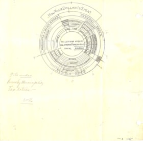
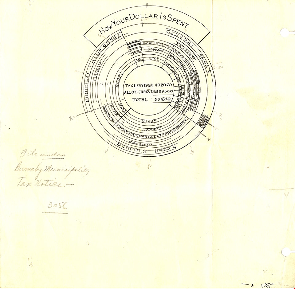
How your dollar is spent
https://search.heritageburnaby.ca/link/museumdescription11159
- Repository
- Burnaby Village Museum
- Date
- 1924
- Collection/Fonds
- Ronald G. Scobbie collection
- Description Level
- Item
- Physical Description
- 1 graph : ink on paper ; 28 x 28 cm
- Scope and Content
- Item consists of a drawing of a circular graph re: Burnaby tax information, "How Your Dollar is Spent" / “Municipal Loans” / General / Schools”.
- Repository
- Burnaby Village Museum
- Collection/Fonds
- Ronald G. Scobbie collection
- Description Level
- Item
- Physical Description
- 1 graph : ink on paper ; 28 x 28 cm
- Scope and Content
- Item consists of a drawing of a circular graph re: Burnaby tax information, "How Your Dollar is Spent" / “Municipal Loans” / General / Schools”.
- Accession Code
- BV003.83.38
- Access Restriction
- No restrictions
- Reproduction Restriction
- No known restrictions
- Date
- 1924
- Media Type
- Textual Record
- Scan Resolution
- 600
- Scan Date
- 15-Jan-2021
- Scale
- 100
- Notes
- Title based on contents of item
- Handwritten notes in pencil read: "File under Burnaby Municipality tax notice" "3056"
Images
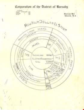
How your dollar is spent
https://search.heritageburnaby.ca/link/museumdescription11160
- Repository
- Burnaby Village Museum
- Date
- 1923
- Collection/Fonds
- Ronald G. Scobbie collection
- Description Level
- Item
- Physical Description
- 1 graph : black ink on paper ; 27 x 21 cm
- Scope and Content
- Item consists of a circular graph drawn on Corporation of the District of Burnaby letterhead paper about Burnaby tax information and is titled "How Your Dollar is Spent" / "Tax Levy - 1923...”.
- Repository
- Burnaby Village Museum
- Collection/Fonds
- Ronald G. Scobbie collection
- Description Level
- Item
- Physical Description
- 1 graph : black ink on paper ; 27 x 21 cm
- Scope and Content
- Item consists of a circular graph drawn on Corporation of the District of Burnaby letterhead paper about Burnaby tax information and is titled "How Your Dollar is Spent" / "Tax Levy - 1923...”.
- Responsibility
- Corporation of the District of Burnaby
- Accession Code
- BV003.83.39
- Access Restriction
- No restrictions
- Reproduction Restriction
- No known restrictions
- Date
- 1923
- Media Type
- Textual Record
- Scan Resolution
- 600
- Scan Date
- 15-Jan-2021
- Scale
- 100
- Notes
- Transcribed title
Images
