More like 'Bill Copeland Sports Centre'
Narrow Results By
Decade
- 2020s 98
- 2010s 70
- 2000s 503
- 1990s 602
- 1980s 465
- 1970s 794
- 1960s 367
- 1950s 524
- 1940s 476
- 1930s 437
- 1920s
- 1910s
- 1900s 205
- 1890s 27
- 1880s 50
- 1870s 4
- 1860s 2
- 1850s 1
- 1840s 1
- 1830s 1
- 1820s 1
- 1810s 1
- 1800s 1
- 1790s 1
- 1780s 1
- 1770s 1
- 1760s 1
- 1750s 1
- 1740s 1
- 1730s 1
- 1720s 1
- 1710s 1
- 1700s 1
- 1690s 1
- 1680s 1
- 1670s 1
- 1660s 1
- 1650s 1
- 1640s 1
- 1630s 1
- 1620s 1
- 1610s 1
- 1600s 1
Creator
- Barrowclough, G.A. 1
- BC Photo Card Company 1
- Bellinger, Bernard 1
- Blake, Frederick "Fred" 1
- Burnaby Village Museum 6
- Burnett and McGugan B.C. Land Surveyors, New Westminster 5
- Burnett, Geoffrey K. 3
- Burnett & McGugan, Engineers and Surveyors 24
- Canadian Photo Company 12
- Challoner-Courtenay, E.J. 2
- Charlton and Rathburn 3
- Dean, H.M. 9
Person / Organization
- Allard, Nancy Davis 1
- All Saints Anglican Church 2
- Alta Vista Baptist Church 1
- A. MacKenzie and Company Jubilee Store 1
- Anderson and Phillips Builders 1
- Ansdell, Elsie Brown-John 1
- Anthony, Bill 1
- Anthony, Mary Warren 2
- Armstrong Avenue School 3
- Atkinson, Betty 1
- Atkinson, Lois 1
- Auvache, Sylvia Murley 1
![D.C. Patterson house, [1915] (date of original), copied 1986 thumbnail](/media/hpo/_Data/_Archives_Images/_Unrestricted/126/171-013.jpg?width=280)
D.C. Patterson house
https://search.heritageburnaby.ca/link/archivedescription34992
- Repository
- City of Burnaby Archives
- Date
- [1915] (date of original), copied 1986
- Collection/Fonds
- Burnaby Historical Society fonds
- Description Level
- Item
- Physical Description
- 1 photograph : b&w ; 8.8 x 12.5 cm print
- Scope and Content
- Photograph of the exterior of the home of Dugald C. Patterson, Sr., and his family. People are standing outside, and a man, possibly D.C. Patterson, is seated at the top of the stairs. The summer gazebo can be seen on the left of the photograph, and there is laundry on a line at the bottom right. …
- Repository
- City of Burnaby Archives
- Date
- [1915] (date of original), copied 1986
- Collection/Fonds
- Burnaby Historical Society fonds
- Subseries
- Patterson family subseries
- Physical Description
- 1 photograph : b&w ; 8.8 x 12.5 cm print
- Description Level
- Item
- Record No.
- 171-013
- Access Restriction
- No restrictions
- Reproduction Restriction
- No known restrictions
- Accession Number
- BHS1986-20
- Scope and Content
- Photograph of the exterior of the home of Dugald C. Patterson, Sr., and his family. People are standing outside, and a man, possibly D.C. Patterson, is seated at the top of the stairs. The summer gazebo can be seen on the left of the photograph, and there is laundry on a line at the bottom right. The Patterson family house was originally located at 7260 Edmonds Street (near Kingsway). It was relocated in 1955 to 7106 18th Avenue and is a city heritage site.
- Media Type
- Photograph
- Notes
- Title based on contents of photograph
- Geographic Access
- Edmonds Street
- 18th Avenue
- Street Address
- 7260 Edmonds Street
- 7106 18th Avenue
- Historic Neighbourhood
- Edmonds (Historic Neighbourhood)
- Planning Study Area
- Stride Avenue Area
Images
![D.C. Patterson house, [1915] (date of original), copied 1986 thumbnail](/media/hpo/_Data/_Archives_Images/_Unrestricted/126/171-013.jpg)
![Fairacres Gazebo and Mansion, [1914] thumbnail](/media/hpo/_Data/_Archives_Images/_Unrestricted/205/241-024.jpg?width=280)
Fairacres Gazebo and Mansion
https://search.heritageburnaby.ca/link/archivedescription36246
- Repository
- City of Burnaby Archives
- Date
- [1914]
- Collection/Fonds
- Burnaby Historical Society fonds
- Description Level
- Item
- Physical Description
- 1 photograph : b&w copy negative ; 7 x 10.5 cm
- Scope and Content
- Photograph of the Fairacres Gazebo and Mansion covered in snow.
- Repository
- City of Burnaby Archives
- Date
- [1914]
- Collection/Fonds
- Burnaby Historical Society fonds
- Subseries
- Burnaby Art Gallery subseries
- Physical Description
- 1 photograph : b&w copy negative ; 7 x 10.5 cm
- Description Level
- Item
- Record No.
- 241-024
- Access Restriction
- No restrictions
- Reproduction Restriction
- No known restrictions
- Accession Number
- BHS1990-05
- Scope and Content
- Photograph of the Fairacres Gazebo and Mansion covered in snow.
- Media Type
- Photograph
- Notes
- Title based on contents of photograph 1 b&w copy print accompanying
- Geographic Access
- Deer Lake Avenue
- Street Address
- 6344 Deer Lake Avenue
- Historic Neighbourhood
- Burnaby Lake (Historic Neighbourhood)
- Planning Study Area
- Douglas-Gilpin Area
Images
![Fairacres Gazebo and Mansion, [1914] thumbnail](/media/hpo/_Data/_Archives_Images/_Unrestricted/205/241-024.jpg)
![Bandsand in Stanley Park, Vancouver, BC, [between 1908 and 1911] thumbnail](/media/hpo/_Data/_BVM_Images/1972/1972_0050_0010_001.jpg?width=280)
Bandsand in Stanley Park, Vancouver, BC
https://search.heritageburnaby.ca/link/museumdescription1071
- Repository
- Burnaby Village Museum
- Date
- [between 1908 and 1911]
- Collection/Fonds
- Burnaby Village Museum Photograph collection
- Description Level
- Item
- Physical Description
- 1 photograph : sepia ; 7.3 x 9.9 cm
- Scope and Content
- Photograph of people walking towards the bandstand in Stanley Park, Vancouver. In 1934, the Malkin Bowl was erected at the site where the banstand used to be. An annotation on the back of the photograph reads, "Band stand in Stanley Park where Malkin Bowl now stands."
- Repository
- Burnaby Village Museum
- Collection/Fonds
- Burnaby Village Museum Photograph collection
- Description Level
- Item
- Physical Description
- 1 photograph : sepia ; 7.3 x 9.9 cm
- Scope and Content
- Photograph of people walking towards the bandstand in Stanley Park, Vancouver. In 1934, the Malkin Bowl was erected at the site where the banstand used to be. An annotation on the back of the photograph reads, "Band stand in Stanley Park where Malkin Bowl now stands."
- Geographic Access
- Vancouver
- Accession Code
- HV972.50.10
- Access Restriction
- No restrictions
- Reproduction Restriction
- No known restrictions
- Date
- [between 1908 and 1911]
- Media Type
- Photograph
- Scan Resolution
- 600
- Scan Date
- 2023-04-04
- Photographer
- Dean, H.M.
- Notes
- Title based on contents of photograph
Images
![Bandsand in Stanley Park, Vancouver, BC, [between 1908 and 1911] thumbnail](/media/hpo/_Data/_BVM_Images/1972/1972_0050_0010_001.jpg)

Begining construction on the Lozells Community Hall
https://search.heritageburnaby.ca/link/archivedescription36420
- Repository
- City of Burnaby Archives
- Date
- 1922
- Collection/Fonds
- Burnaby Historical Society fonds
- Description Level
- Item
- Physical Description
- 1 photograph : col. ; 7 x 11 cm print
- Scope and Content
- Photograph of the begining of construction on the Lozells Community Hall.
- Repository
- City of Burnaby Archives
- Date
- 1922
- Collection/Fonds
- Burnaby Historical Society fonds
- Subseries
- Photographs subseries
- Physical Description
- 1 photograph : col. ; 7 x 11 cm print
- Description Level
- Item
- Record No.
- 267-001
- Access Restriction
- No restrictions
- Reproduction Restriction
- No known restrictions
- Accession Number
- BHS1991-34
- Scope and Content
- Photograph of the begining of construction on the Lozells Community Hall.
- Media Type
- Photograph
- Notes
- Title based on contents of photograph
- Print is a colour copy of a sepia original
- Geographic Access
- Lozells Avenue
- Government Road
- Historic Neighbourhood
- Lozells (Historic Neighbourhood)
- Planning Study Area
- Government Road Area
Images

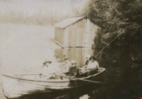
Boating at Campbell River
https://search.heritageburnaby.ca/link/archivedescription39350
- Repository
- City of Burnaby Archives
- Date
- 1921
- Collection/Fonds
- Peers Family and Hill Family fonds
- Description Level
- Item
- Physical Description
- 1 photograph : b&w ; 5.2 x 7.3 cm on page 24.5 x 32.5 cm (pasted in album)
- Scope and Content
- Photograph of five people sitting in a boat, next to a small boathouse. All are unidentified but the location is given as Campbell River.
- Repository
- City of Burnaby Archives
- Date
- 1921
- Collection/Fonds
- Peers Family and Hill Family fonds
- Physical Description
- 1 photograph : b&w ; 5.2 x 7.3 cm on page 24.5 x 32.5 cm (pasted in album)
- Description Level
- Item
- Record No.
- 477-669
- Access Restriction
- No restrictions
- Reproduction Restriction
- No known restrictions
- Accession Number
- 2007-12
- Scope and Content
- Photograph of five people sitting in a boat, next to a small boathouse. All are unidentified but the location is given as Campbell River.
- Media Type
- Photograph
- Notes
- Title based on caption accompanying photograph
Images

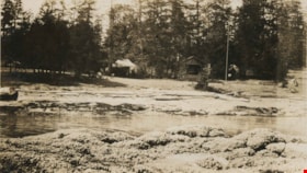
Camping at Yellow Point
https://search.heritageburnaby.ca/link/archivedescription34314
- Repository
- City of Burnaby Archives
- Date
- 1924
- Collection/Fonds
- Burnaby Historical Society fonds
- Description Level
- Item
- Physical Description
- 1 photograph : b&w : 8 x 13 cm on page 17.5 x 24.5 cm
- Scope and Content
- Photograph of a cabin, tents and campsite alongside a small stream. The location is identified as Yellow Point, which was a regular vacation spot for members of the Hill and Peers families of Burnaby.
- Repository
- City of Burnaby Archives
- Date
- 1924
- Collection/Fonds
- Burnaby Historical Society fonds
- Subseries
- Peers family subseries
- Physical Description
- 1 photograph : b&w : 8 x 13 cm on page 17.5 x 24.5 cm
- Description Level
- Item
- Record No.
- 020-021
- Access Restriction
- No restrictions
- Reproduction Restriction
- No known restrictions
- Accession Number
- BHS2007-04
- Scope and Content
- Photograph of a cabin, tents and campsite alongside a small stream. The location is identified as Yellow Point, which was a regular vacation spot for members of the Hill and Peers families of Burnaby.
- Subjects
- Buildings - Residential - Cabins
- Recreational Activities - Camping
- Geographic Features - Channels
- Media Type
- Photograph
- Notes
- Title based on caption accompanying photograph
Images
![Central Park Auto Tourist Grounds, Vancouver Canada, [1923] thumbnail](/media/hpo/_Data/_Archives_Images/_Unrestricted/371/449-007.jpg?width=280)
Central Park Auto Tourist Grounds, Vancouver Canada
https://search.heritageburnaby.ca/link/archivedescription38512
- Repository
- City of Burnaby Archives
- Date
- [1923]
- Collection/Fonds
- Burnaby Historical Society fonds
- Description Level
- Item
- Physical Description
- 1 photograph : sepia postcard ; 9 x 14 cm
- Scope and Content
- Photographic postcard of the Central Park auto tourist grounds. Two unidentified men can be seen standing in front of a car which is parked next to the campground building. In the background, a clothesline has been strung holding towels and blankets.
- Repository
- City of Burnaby Archives
- Date
- [1923]
- Collection/Fonds
- Burnaby Historical Society fonds
- Subseries
- Photographs subseries
- Physical Description
- 1 photograph : sepia postcard ; 9 x 14 cm
- Description Level
- Item
- Record No.
- 449-007
- Access Restriction
- No restrictions
- Reproduction Restriction
- No known restrictions
- Accession Number
- BHS2007-04
- Scope and Content
- Photographic postcard of the Central Park auto tourist grounds. Two unidentified men can be seen standing in front of a car which is parked next to the campground building. In the background, a clothesline has been strung holding towels and blankets.
- Subjects
- Buildings - Commercial - Hotels and Motels
- Geographic Features - Parks
- Documentary Artifacts - Postcards
- Recreational Activities - Camping
- Media Type
- Photograph
- Notes
- Title based on caption
- Geographic Access
- Central Park
- Imperial Street
- Street Address
- 3883 Imperial Street
- Historic Neighbourhood
- Central Park (Historic Neighbourhood)
- Planning Study Area
- Maywood Area
Images
![Central Park Auto Tourist Grounds, Vancouver Canada, [1923] thumbnail](/media/hpo/_Data/_Archives_Images/_Unrestricted/371/449-007.jpg)

Construction on Lozells Community Hall
https://search.heritageburnaby.ca/link/archivedescription36421
- Repository
- City of Burnaby Archives
- Date
- 1922
- Collection/Fonds
- Burnaby Historical Society fonds
- Description Level
- Item
- Physical Description
- 1 photograph : col. ; 7 x 11 cm print
- Scope and Content
- Photograph of the middle of construction on the Lozells Community Hall.
- Repository
- City of Burnaby Archives
- Date
- 1922
- Collection/Fonds
- Burnaby Historical Society fonds
- Subseries
- Photographs subseries
- Physical Description
- 1 photograph : col. ; 7 x 11 cm print
- Description Level
- Item
- Record No.
- 267-002
- Access Restriction
- No restrictions
- Reproduction Restriction
- No known restrictions
- Accession Number
- BHS1991-34
- Scope and Content
- Photograph of the middle of construction on the Lozells Community Hall.
- Media Type
- Photograph
- Notes
- Title based on contents of photograph
- Print is a colour copy of a sepia original
- Geographic Access
- Lozells Avenue
- Government Road
- Historic Neighbourhood
- Lozells (Historic Neighbourhood)
- Planning Study Area
- Government Road Area
Images

![D.C. Patterson's Gazebo, [1912] (date of original), copied 1986 thumbnail](/media/hpo/_Data/_Archives_Images/_Unrestricted/126/171-009.jpg?width=280)
D.C. Patterson's Gazebo
https://search.heritageburnaby.ca/link/archivedescription34988
- Repository
- City of Burnaby Archives
- Date
- [1912] (date of original), copied 1986
- Collection/Fonds
- Burnaby Historical Society fonds
- Description Level
- Item
- Physical Description
- 1 photograph : b&w ; 8.8 x 12.5 cm print
- Scope and Content
- Photograph of D.C. Patterson, Sr., with two children standing in the gazebo at the family home. Mr. Patterson is holding a child inside the gazebo, and another child is seated in a small chair outside it. The house was originally located at 7260 Edmonds Street (near Kingsway). It was relocated i…
- Repository
- City of Burnaby Archives
- Date
- [1912] (date of original), copied 1986
- Collection/Fonds
- Burnaby Historical Society fonds
- Subseries
- Patterson family subseries
- Physical Description
- 1 photograph : b&w ; 8.8 x 12.5 cm print
- Description Level
- Item
- Record No.
- 171-009
- Access Restriction
- No restrictions
- Reproduction Restriction
- No known restrictions
- Accession Number
- BHS1986-20
- Scope and Content
- Photograph of D.C. Patterson, Sr., with two children standing in the gazebo at the family home. Mr. Patterson is holding a child inside the gazebo, and another child is seated in a small chair outside it. The house was originally located at 7260 Edmonds Street (near Kingsway). It was relocated in 1955 to 7106 18th Avenue and is a city heritage site.
- Subjects
- Buildings - Recreational - Gazebos
- Names
- Patterson, Dugald C. Sr.
- Media Type
- Photograph
- Notes
- Title based on contents of photograph
- Geographic Access
- Edmonds Street
- 18th Avenue
- Street Address
- 7260 Edmonds Street
- 7106 18th Avenue
- Historic Neighbourhood
- Edmonds (Historic Neighbourhood)
- Planning Study Area
- Stride Avenue Area
Images
![D.C. Patterson's Gazebo, [1912] (date of original), copied 1986 thumbnail](/media/hpo/_Data/_Archives_Images/_Unrestricted/126/171-009.jpg)
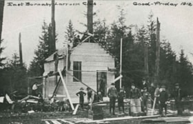
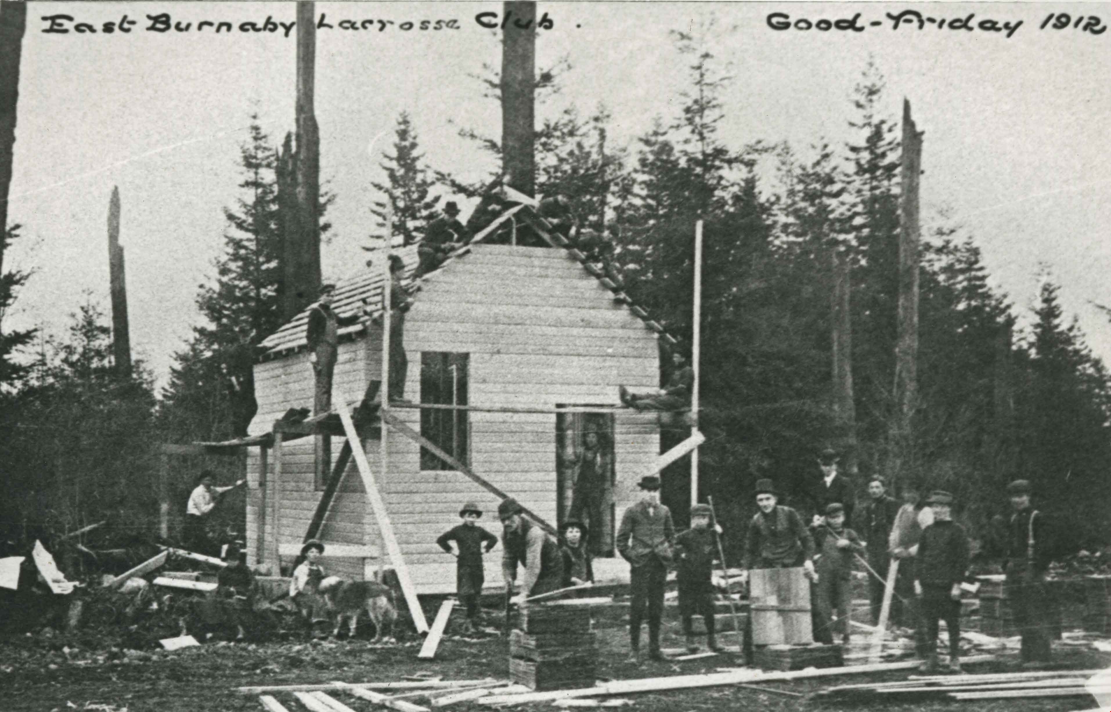
East Burnaby Lacrosse Club Clubhouse
https://search.heritageburnaby.ca/link/archivedescription35358
- Repository
- City of Burnaby Archives
- Date
- 1912 (date of original), copied 1986
- Collection/Fonds
- Burnaby Historical Society fonds
- Description Level
- Item
- Physical Description
- 1 photograph : b&w ; 12.7 x 17.8 cm print
- Scope and Content
- Photograph of the East Burnaby Lacrosse Club clubhouse building bee on the grounds of Edmonds Street School. Sitting on the scaffolding against the pole is George Leaf, manager of the club. The East Burnaby Lacrosse Club members scrounged materials and built the clubhouse in one day.
- Repository
- City of Burnaby Archives
- Date
- 1912 (date of original), copied 1986
- Collection/Fonds
- Burnaby Historical Society fonds
- Subseries
- Pioneer Tales subseries
- Physical Description
- 1 photograph : b&w ; 12.7 x 17.8 cm print
- Description Level
- Item
- Record No.
- 204-215
- Access Restriction
- No restrictions
- Reproduction Restriction
- No known restrictions
- Accession Number
- BHS1988-03
- Scope and Content
- Photograph of the East Burnaby Lacrosse Club clubhouse building bee on the grounds of Edmonds Street School. Sitting on the scaffolding against the pole is George Leaf, manager of the club. The East Burnaby Lacrosse Club members scrounged materials and built the clubhouse in one day.
- Subjects
- Buildings - Recreational
- Organizations
- Media Type
- Photograph
- Notes
- Title based on contents of photograph
- Annotation at top of photograph reads, "East Burnaby Lacrosse Club / Good Friday 1912"
- Geographic Access
- Edmonds Street
- Street Address
- 7355 Canada Way
- Historic Neighbourhood
- Edmonds (Historic Neighbourhood)
- Planning Study Area
- Edmonds Area
Images
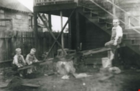
Grant family
https://search.heritageburnaby.ca/link/archivedescription36867
- Repository
- City of Burnaby Archives
- Date
- 1914 (date of original), copied 1992
- Collection/Fonds
- Burnaby Historical Society fonds
- Description Level
- Item
- Physical Description
- 1 photograph : b&w ; 8.3 x 12.7 cm print
- Scope and Content
- Photograph of the Grant brothers; eldest Bill, (above), with George and Harry on a teeter totter outside the family home at 2540 Marlborough Avenue (renumbered 6591 Marlborough Avenue).
- Repository
- City of Burnaby Archives
- Date
- 1914 (date of original), copied 1992
- Collection/Fonds
- Burnaby Historical Society fonds
- Subseries
- Burnaby Centennial Anthology subseries
- Physical Description
- 1 photograph : b&w ; 8.3 x 12.7 cm print
- Description Level
- Item
- Record No.
- 315-325
- Access Restriction
- No restrictions
- Reproduction Restriction
- No known restrictions
- Accession Number
- BHS1994-04
- Scope and Content
- Photograph of the Grant brothers; eldest Bill, (above), with George and Harry on a teeter totter outside the family home at 2540 Marlborough Avenue (renumbered 6591 Marlborough Avenue).
- Media Type
- Photograph
- Notes
- Title based on contents of photograph
- Geographic Access
- Marlborough Avenue
- Street Address
- 6591 Marlborough Avenue
- Historic Neighbourhood
- Central Park (Historic Neighbourhood)
- Planning Study Area
- Marlborough Area
Images


Inauguration of the water system at Burnaby
https://search.heritageburnaby.ca/link/archivedescription35938
- Repository
- City of Burnaby Archives
- Date
- July 16, 1912
- Collection/Fonds
- Burnaby Historical Society fonds
- Description Level
- Item
- Physical Description
- 1 photograph : b&w postcard ; 8.9 x 14.0 cm
- Scope and Content
- Photographic postcard of Reeve Weart addressing a crowd gathered around the bandstand in Central Park for the inauguration of Burnaby Water Works. The Reeve is standing as he looks towards the crowd. Other men are seated in a semi-circle inside the bandstand. This was known as "Splash Day."
- Repository
- City of Burnaby Archives
- Date
- July 16, 1912
- Collection/Fonds
- Burnaby Historical Society fonds
- Subseries
- Pioneer Tales subseries
- Physical Description
- 1 photograph : b&w postcard ; 8.9 x 14.0 cm
- Description Level
- Item
- Record No.
- 204-798
- Access Restriction
- No restrictions
- Reproduction Restriction
- No known restrictions
- Accession Number
- BHS1988-03
- Scope and Content
- Photographic postcard of Reeve Weart addressing a crowd gathered around the bandstand in Central Park for the inauguration of Burnaby Water Works. The Reeve is standing as he looks towards the crowd. Other men are seated in a semi-circle inside the bandstand. This was known as "Splash Day."
- Subjects
- Buildings - Recreational - Bandstands
- Persons - Crowds
- Officials - Mayors and Reeves
- Public Services - Utilities
- Public Services - Public Works
- Documentary Artifacts - Postcards
- Names
- Weart, R.W.
- Media Type
- Photograph
- Notes
- 1 b&w copy negative accompanying
- Annotation of back of postcard reads, "July 16 - 1912 / Inauguration of the water system at Burnaby"
- Geographic Access
- Central Park
- Imperial Street
- Street Address
- 3883 Imperial Street
- Historic Neighbourhood
- Central Park (Historic Neighbourhood)
- Planning Study Area
- Maywood Area
Images


Interview with Dr Blythe Eagles and Dr Violet Eagles 10-Jun-75 - Track 10
https://search.heritageburnaby.ca/link/oralhistory72
- Repository
- City of Burnaby Archives
- Date Range
- 1929-1945
- Length
- 0:07:33
- Summary
- This portion of the interview pertains to Dr Blythe Alfred Eagles and Dr Violet Evelyn (Dunbar) Eagles' memories of entertainment enjoyed during the war years, including the establishment of the Valleyview Community Centre, versus how people found entertainment during the Depression.
- Repository
- City of Burnaby Archives
- Summary
- This portion of the interview pertains to Dr Blythe Alfred Eagles and Dr Violet Evelyn (Dunbar) Eagles' memories of entertainment enjoyed during the war years, including the establishment of the Valleyview Community Centre, versus how people found entertainment during the Depression.
- Date Range
- 1929-1945
- Photo Info
- Mrs. Dunbar, Dr. Blythe Eagles and Dr. Violet (Dunbar) Eagles, June 1967. Item no. 404-002
- Length
- 0:07:33
- Interviewer
- Bradbury, Dr. Bettina
- Interview Date
- 10-Jun-75
- Scope and Content
- Recording is a taped interview with Dr Blythe Eagles and his wife Dr Violet Eagles by SFU (Simon Fraser University) graduate student Bettina Bradbury (and Ross S. McLeod) June 10, 1975. Major themes discussed are: the Depression, the War Years and Burnaby Lake District. To view "Narrow By" terms for each track expand this description and see "Notes".
- Biographical Notes
- Blythe's paternal grandparents, Charles and Maude Eagles immigrated to New Westminster in 1887. Their son Jack married Amelia Jane Johnston, and Blythe Eagles was born in New Westminster in 1902. In 1918 Blythe enrolled at the University of British Columbia, and took a Physiology class with eight other top students - his future wife, Violet Dunbar was the lone woman in the class. Blythe graduated in 1922, winning the Governor General's Gold Medal as top student. He received his MA in 1924 and his PhD in 1926 from the University of Toronto. He then completed his post-doctoral study at the National Institute for Medical Research in London, England. In 1933 Dr. Eagles became head of the Department of Dairying (1936-1955), Chairman of the Division of Animal Science (1955-1967), and Dean of the Faculty of Agriculture (in 1949 until his retirement in 1967). In 1968 he received an Honourary Doctor of Science Award from UBC Blythe was also one of the first appointments to the Burnaby Town Planning Commission. Violet Evelyn Dunbar was born September 29, 1899 in Ontario, the eldest child of John and Mary (Tompson) Dunbar. Violet attained her BA in 1921 and MA in 1922 from the University of British Columbia. In 1922 she attended the Provincial Normal School and within six months had a teaching certificate and taught at Lord Hudson School in 1923. In September 1923 she was awarded a two-year scholarship to the University of Toronto, where she joined Blythe in the Bio-Chemistry Department. She received a second MA and a PhD in 1929. Her graduate studies entailed research in pure proteins and enzymes related to the commercial production of cheese. Through this work she was recognized as one of the leading enzyme chemists in the country, being a senior lab instructor of biochemistry. Violet was one of the founders of the Burnaby Council of Women and active member of the International Council of Women. Blythe and Violet Eagles purchased property at Deer Lake in 1929 and began construction of their home shortly before their marriage on June 25, 1930. The Drs. Blythe and Violet Eagles Estate is a unique expression of the talents and tastes of both the Eagles and Frank Ebenezer Buck (1875-1970) who was head of the Horticultural Department and the Campus Landscape Architect at U.B.C. and established the plan for the Eagles garden while Blythe selected many of the plantings. The Eagles themselves designed the house as a romantic cottage inspired by the British Arts and Crafts style. Violet was an enthusiastic amateur gardener, maintaining and continually developing the garden. The Eagles were active volunteers in the local community as well as at UBC. When Simon Fraser University opened in Burnaby, they became well-known for entertaining dignitaries and special guests of the university in their lavish garden. After Violet's death in 1993, the estate was sold to the City of Burnaby. The funds were used to establish a Chair in Agriculture at the University of British Columbia in their memory.
- Total Tracks
- 11
- Total Length
- 1:24:01
- Interviewee Name
- Eagles, Dr. Blythe
- Eagles, Dr. Violet
- Interviewer Bio
- Bettina Bradbury teaches history and women's studies at York University. She is the author of Wife to Widow. Lives, Laws and Politics in Nineteenth-century Montreal. (Vancouver: University of British Columbia Press, June 2011), 520p; Working Families. Age, Gender and Daily Survival in Industrializing Montreal. (Toronto: Canadian Social History Series, McClelland and Stewart, 1993); (Republished Toronto: Oxford University Press, 1996) (3rd edition, Toronto: University of Toronto Press, 2007). These interviews were undertaken after she completed her MA at Simon Fraser University in 1975 with the support of an LIP grant.
- Collection/Fonds
- Burnaby Historical Society fonds
- Subseries
- Oral history subseries
- Media Type
- Sound Recording
- Web Notes
- Interview was digitized in 2010 allowing it to be accessible on Heritage Burnaby. The digitization project was initiated by the Community Heritage Commission with support from City of Burnaby Council and the BC History Digitization Program of the Irving K. Barber Learning Centre, University of British Columbia. It was recognized by the Heritage Society of BC with an award in 2012.
Images

Audio Tracks
Track ten of interview with Dr Blythe Eagles and Dr Violet Eagles
Track ten of interview with Dr Blythe Eagles and Dr Violet Eagles
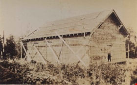
https://search.heritageburnaby.ca/media/hpo/_Data/_Archives_Oral_Histories/_Unrestricted/100-13-08/100-13-08_Track_10.mp3![Jim Phillips' photography shack, [1912] thumbnail](/media/hpo/_Data/_Archives_Images/_Unrestricted/487/487-025.jpg?width=280)
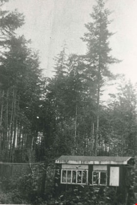
Jim Phillips' photography shack
https://search.heritageburnaby.ca/link/archivedescription57725
- Repository
- City of Burnaby Archives
- Date
- [1912]
- Collection/Fonds
- J.W. Phillips fonds
- Description Level
- Item
- Physical Description
- 1 photograph : b&w glass negative ; 15.5 x 11 cm
- Scope and Content
- Photograph of the little shack where Jim Phillips, a photographer and artist, did his developing and painting. It was located next to the Holmes family home on Ellesmere Avenue. Note the thick bushland. Jim Phillips was killed in the First World War.
- Repository
- City of Burnaby Archives
- Date
- [1912]
- Collection/Fonds
- J.W. Phillips fonds
- Physical Description
- 1 photograph : b&w glass negative ; 15.5 x 11 cm
- Material Details
- Emulsion measures 15.5 x 11 cm on the glass; entire glass plate measures 16 x 12 cm
- Description Level
- Item
- Record No.
- 487-025
- Access Restriction
- No restrictions
- Reproduction Restriction
- No known restrictions
- Accession Number
- 2008-18
- Scope and Content
- Photograph of the little shack where Jim Phillips, a photographer and artist, did his developing and painting. It was located next to the Holmes family home on Ellesmere Avenue. Note the thick bushland. Jim Phillips was killed in the First World War.
- Subjects
- Buildings - Recreational
- Media Type
- Photograph
- Photographer
- Phillips, James William "Jim"
- Notes
- Title based on contents of photograph
- Geographic Access
- Ellesmere Avenue
- Historic Neighbourhood
- Capitol Hill (Historic Neighbourhood)
- Planning Study Area
- Capitol Hill Area
Images
![Jim Phillips' photography shack, [1912] thumbnail](/media/hpo/_Data/_Archives_Images/_Unrestricted/487/487-025.jpg)
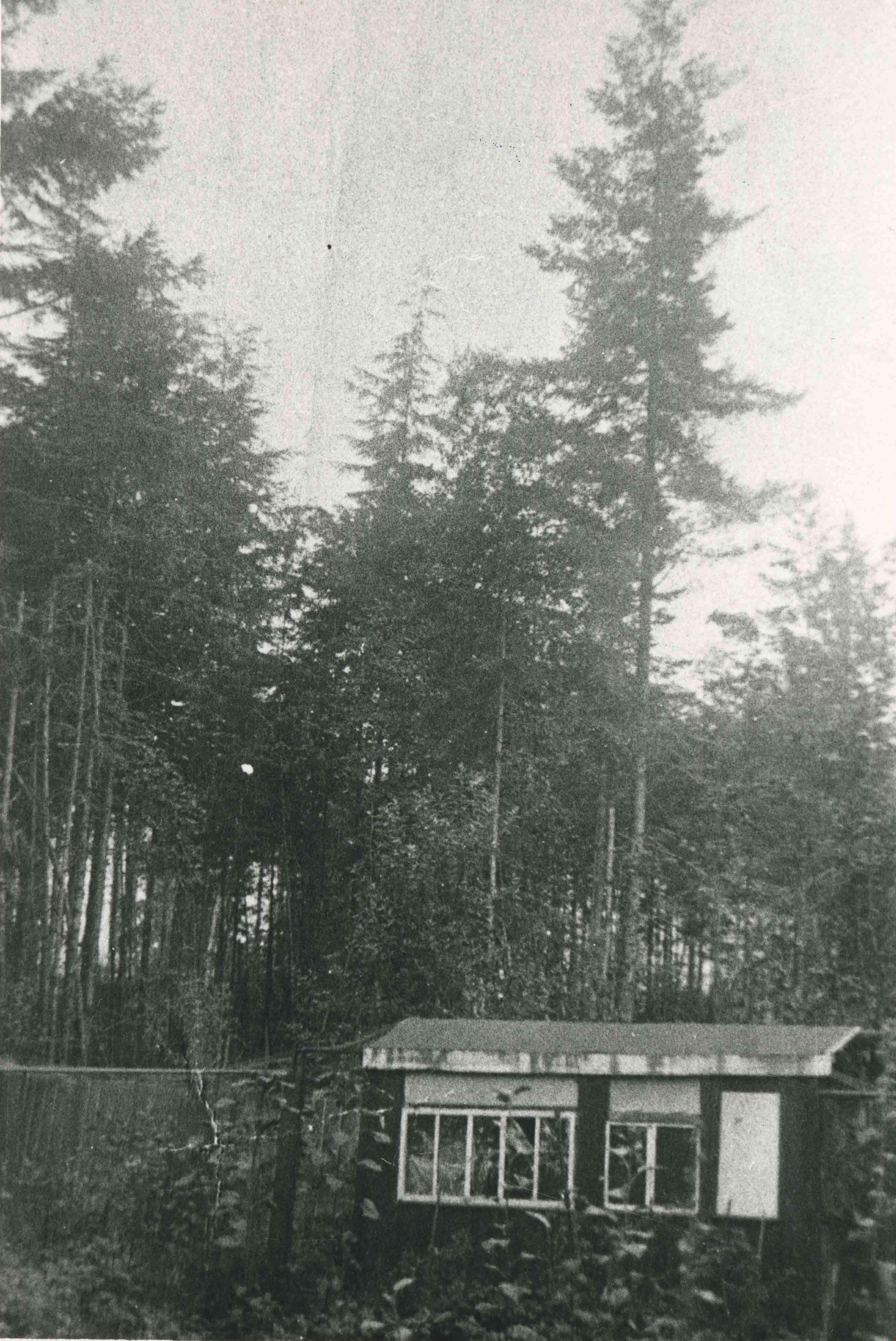
Jim Phillips' photography shack
https://search.heritageburnaby.ca/link/archivedescription35840
- Repository
- City of Burnaby Archives
- Date
- 1912 (date of original), copied 1986
- Collection/Fonds
- Burnaby Historical Society fonds
- Description Level
- Item
- Physical Description
- 1 photograph : b&w ; 12.7 x 17.8 cm print
- Scope and Content
- Photograph of the little shack where Jim Phillips, a photographer and artist, did his developing and painting. It was located next to the Holmes family home on Ellesmere Avenue. Note the thick bushland. Jim Phillips was killed in the First World War.
- Repository
- City of Burnaby Archives
- Date
- 1912 (date of original), copied 1986
- Collection/Fonds
- Burnaby Historical Society fonds
- Subseries
- Pioneer Tales subseries
- Physical Description
- 1 photograph : b&w ; 12.7 x 17.8 cm print
- Description Level
- Item
- Record No.
- 204-699
- Access Restriction
- No restrictions
- Reproduction Restriction
- No known restrictions
- Accession Number
- BHS1988-03
- Scope and Content
- Photograph of the little shack where Jim Phillips, a photographer and artist, did his developing and painting. It was located next to the Holmes family home on Ellesmere Avenue. Note the thick bushland. Jim Phillips was killed in the First World War.
- Subjects
- Buildings - Recreational
- Media Type
- Photograph
- Photographer
- Phillips, James William "Jim"
- Notes
- Title based on contents of photograph
- Item no. 487-026 and 204-703 are also of this building
- Geographic Access
- Ellesmere Avenue
- Historic Neighbourhood
- Capitol Hill (Historic Neighbourhood)
- Planning Study Area
- Capitol Hill Area
Images
![Jim Phillips' photography shack, [1912] (date of original), copied 1986 thumbnail](/media/hpo/_Data/_Archives_Images/_Unrestricted/204/204-703.jpg?width=280)
Jim Phillips' photography shack
https://search.heritageburnaby.ca/link/archivedescription35844
- Repository
- City of Burnaby Archives
- Date
- [1912] (date of original), copied 1986
- Collection/Fonds
- Burnaby Historical Society fonds
- Description Level
- Item
- Physical Description
- 1 photograph : b&w ; 12.7 x 17.8 cm print
- Scope and Content
- Photograph of the little shack where Jim Phillips, a photographer and artist, did his developing and painting. It was located next to the Holmes family home on Ellesmere Avenue. Note the thick bushland. Jim Phillips was killed in the First World War.
- Repository
- City of Burnaby Archives
- Date
- [1912] (date of original), copied 1986
- Collection/Fonds
- Burnaby Historical Society fonds
- Subseries
- Pioneer Tales subseries
- Physical Description
- 1 photograph : b&w ; 12.7 x 17.8 cm print
- Description Level
- Item
- Record No.
- 204-703
- Access Restriction
- No restrictions
- Reproduction Restriction
- No known restrictions
- Accession Number
- BHS1988-03
- Scope and Content
- Photograph of the little shack where Jim Phillips, a photographer and artist, did his developing and painting. It was located next to the Holmes family home on Ellesmere Avenue. Note the thick bushland. Jim Phillips was killed in the First World War.
- Subjects
- Buildings - Recreational
- Media Type
- Photograph
- Photographer
- Phillips, James William "Jim"
- Notes
- Title based on contents of photograph
- Item no. 204-699 and 487-026 are also of this building
- Geographic Access
- Ellesmere Avenue
- Historic Neighbourhood
- Capitol Hill (Historic Neighbourhood)
- Planning Study Area
- Capitol Hill Area
Images
![Jim Phillips' photography shack, [1912] (date of original), copied 1986 thumbnail](/media/hpo/_Data/_Archives_Images/_Unrestricted/204/204-703.jpg)
![Kitty Hill and Florence Hart boating on Deer Lake, [1910] thumbnail](/media/hpo/_Data/_Archives_Images/_Unrestricted/477/477-090.jpg?width=280)
Kitty Hill and Florence Hart boating on Deer Lake
https://search.heritageburnaby.ca/link/archivedescription38771
- Repository
- City of Burnaby Archives
- Date
- [1910]
- Collection/Fonds
- Peers Family and Hill Family fonds
- Description Level
- Item
- Physical Description
- 1 photograph : b&w ; 8 x 10 cm on page 11.5 x 14 cm (pasted in album)
- Scope and Content
- Photograph of Kitty Hill (turned away) and Florence Hart boating on Deer Lake. Written around the border of the photograph is the following: "You would look away just as I took this. Do you remember how cross I was about it?" The boathouse is most likely that belonging to Kitty's father, Claude H…
- Repository
- City of Burnaby Archives
- Date
- [1910]
- Collection/Fonds
- Peers Family and Hill Family fonds
- Physical Description
- 1 photograph : b&w ; 8 x 10 cm on page 11.5 x 14 cm (pasted in album)
- Description Level
- Item
- Record No.
- 477-090
- Access Restriction
- No restrictions
- Reproduction Restriction
- No known restrictions
- Accession Number
- 2007-12
- Scope and Content
- Photograph of Kitty Hill (turned away) and Florence Hart boating on Deer Lake. Written around the border of the photograph is the following: "You would look away just as I took this. Do you remember how cross I was about it?" The boathouse is most likely that belonging to Kitty's father, Claude Hill, on Deer Lake.
- Subjects
- Buildings - Residential - Boathouses
- Recreational Activities - Boating
- Geographic Features - Lakes and Ponds
- Media Type
- Photograph
- Notes
- Title based on contents of photograph
- Geographic Access
- Deer Lake
- Historic Neighbourhood
- Burnaby Lake (Historic Neighbourhood)
Images
![Kitty Hill and Florence Hart boating on Deer Lake, [1910] thumbnail](/media/hpo/_Data/_Archives_Images/_Unrestricted/477/477-090.jpg)
![Love farmhouse swing, [ca. 1918] (date of original), copied 1989 thumbnail](/media/hpo/_Data/_BVM_Images/2018/2018_0041_0192_001.jpg?width=280)
Love farmhouse swing
https://search.heritageburnaby.ca/link/museumdescription10012
- Repository
- Burnaby Village Museum
- Date
- [ca. 1918] (date of original), copied 1989
- Collection/Fonds
- Burnaby Village Museum fonds
- Description Level
- Item
- Physical Description
- 1 photograph : b&w negative ; 35 mm
- Scope and Content
- Photograph of an an unidentified woman sitting on a large wood framed swing with a group of unidentified children sitting at her feet.The swing is in the yard of the Love farmhouse. There is a tall tree to the right and several trees in the background, the ground is covered in tall grass.
- Repository
- Burnaby Village Museum
- Collection/Fonds
- Burnaby Village Museum fonds
- Series
- Jesse Love farmhouse series
- Subseries
- Love family photographs subseries
- Description Level
- Item
- Physical Description
- 1 photograph : b&w negative ; 35 mm
- Scope and Content
- Photograph of an an unidentified woman sitting on a large wood framed swing with a group of unidentified children sitting at her feet.The swing is in the yard of the Love farmhouse. There is a tall tree to the right and several trees in the background, the ground is covered in tall grass.
- Geographic Access
- Cumberland Street
- Street Address
- 7651 Cumberland Street
- Accession Code
- BV018.41.192
- Access Restriction
- No restrictions
- Reproduction Restriction
- May be restricted by third party rights
- Date
- [ca. 1918] (date of original), copied 1989
- Media Type
- Photograph
- Historic Neighbourhood
- East Burnaby (Historic Neighbourhood)
- Planning Study Area
- Cariboo-Armstrong Area
- Scan Resolution
- 2400
- Scan Date
- 4-Mar-2019
- Scale
- 100
- Notes
- Title based on contents of photograph
- 1 b&w copy print accompanying
Images
![Love farmhouse swing, [ca. 1918] (date of original), copied 1989 thumbnail](/media/hpo/_Data/_BVM_Images/2018/2018_0041_0192_001.jpg)
Lozells Community Hall near completion
https://search.heritageburnaby.ca/link/archivedescription36422
- Repository
- City of Burnaby Archives
- Date
- 1922
- Collection/Fonds
- Burnaby Historical Society fonds
- Description Level
- Item
- Physical Description
- 1 photograph : col. ; 7 x 11 cm print
- Scope and Content
- Photograph of the Lozells Community Hall near completion.
- Repository
- City of Burnaby Archives
- Date
- 1922
- Collection/Fonds
- Burnaby Historical Society fonds
- Subseries
- Photographs subseries
- Physical Description
- 1 photograph : col. ; 7 x 11 cm print
- Description Level
- Item
- Record No.
- 267-003
- Access Restriction
- No restrictions
- Reproduction Restriction
- No known restrictions
- Accession Number
- BHS1991-34
- Scope and Content
- Photograph of the Lozells Community Hall near completion.
- Media Type
- Photograph
- Notes
- Title based on contents of photograph
- Print is a colour copy of a sepia original
- Geographic Access
- Lozells Avenue
- Government Road
- Historic Neighbourhood
- Lozells (Historic Neighbourhood)
- Planning Study Area
- Government Road Area
Images


Opening of Confederation park playground
https://search.heritageburnaby.ca/link/archivedescription38658
- Repository
- City of Burnaby Archives
- Date
- 1927
- Collection/Fonds
- Burnaby Historical Society fonds
- Description Level
- Item
- Physical Description
- 1 photograph : b&w ; 18.7 x 23 cm
- Scope and Content
- Photograph of a crowd gathered in front of a wooden Gazebo at Confederation park. An unidentified man is seen standing on the step of the structure, addressing the group. A few houses on Capitol Hill are visible in the background. A note on the back of the photograph indicates that it was taken dur…
- Repository
- City of Burnaby Archives
- Date
- 1927
- Collection/Fonds
- Burnaby Historical Society fonds
- Subseries
- North Burnaby Board of Trade subseries
- Physical Description
- 1 photograph : b&w ; 18.7 x 23 cm
- Description Level
- Item
- Record No.
- 476-001
- Access Restriction
- No restrictions
- Reproduction Restriction
- No known restrictions
- Accession Number
- BHS2005-8
- Scope and Content
- Photograph of a crowd gathered in front of a wooden Gazebo at Confederation park. An unidentified man is seen standing on the step of the structure, addressing the group. A few houses on Capitol Hill are visible in the background. A note on the back of the photograph indicates that it was taken during the opening of the Confederation Park playground in 1927.
- Media Type
- Photograph
- Notes
- Title based on caption accompanying the photograph
- Geographic Access
- Confederation Park
- Willingdon Avenue
- Street Address
- 250 Willingdon Avenue
- Historic Neighbourhood
- Capitol Hill (Historic Neighbourhood)
- Planning Study Area
- Capitol Hill Area
Images
