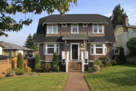
Willingdon Heights Neighbourhood
https://search.heritageburnaby.ca/link/landmark777
- Repository
- Burnaby Heritage Planning
- Associated Dates
- 1955-2008
- Heritage Value
- The convenient location of Willingdon Heights to the Trans Canada Highway, Lougheed Highway and Hastings Street has fostered its development as a primarily residential commuter neighbourhood. Characterised in the post-World War Two period by predominantly single-family developments, the neighbourhood has retained this identity despite some higher density apartment buildings now found there.
- Planning Study Area
- Willingdon Heights Area
Images
W.J. Mathers House 'Altnadene'
https://search.heritageburnaby.ca/link/landmark532
- Repository
- Burnaby Heritage Planning
- Description
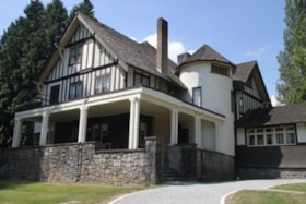
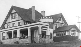
- The W.J. Mathers House 'Altnadene', is a two-and-one-half storey wood frame house set in a large terraced garden, now located in Deer Lake Park. Built as a family home, it is designed in the British Arts and Crafts style enriched by Tudor, Romanesque, and medieval details.
- Associated Dates
- 1912
- Formal Recognition
- Heritage Designation, Community Heritage Register
- Other Names
- William & Mary Mathers Residence
- Street View URL
- Google Maps Street View
- Repository
- Burnaby Heritage Planning
- Other Names
- William & Mary Mathers Residence
- Geographic Access
- Deer Lake Avenue
- Associated Dates
- 1912
- Formal Recognition
- Heritage Designation, Community Heritage Register
- Enactment Type
- Bylaw No. 9807
- Enactment Date
- 23/11/1992
- Description
- The W.J. Mathers House 'Altnadene', is a two-and-one-half storey wood frame house set in a large terraced garden, now located in Deer Lake Park. Built as a family home, it is designed in the British Arts and Crafts style enriched by Tudor, Romanesque, and medieval details.
- Heritage Value
- 'Altnadene' was constructed in the Deer Lake Crescent subdivision, which was originally promoted as an upper class neighbourhood. It represents one of the first residential developments in the City of Burnaby that required buildings to be of a specific value, thus demonstrating the desire for exclusivity among the successful businessmen who chose to settle in the area. The house and grounds illustrate the social, cultural, lifestyle and leisure sensibilities of the owners in the Deer Lake Crescent subdivision: such values as social aspiration, racial exclusivity, demonstration of architectural taste, importance of a landscaped garden, and the provision of facilities for fashionable pursuits such as lawn tennis. The estate is historically significant for its connection to William John Mathers (1859-1929), an early pioneer who arrived in New Westminster in 1876, an enterprising grain dealer, businessman, alderman, president of the Board of Trade and various other local organizations, and a 'public spirited and progressive citizen.' Designed for Mathers and his wife, Mary Elizabeth Jane (Whelan) Mathers (1869-1939), by Burnaby architect Frank William Macey (1863-1935), the Arts and Crafts style of the Mathers House contributes to the overall stylistic ambiance of the collection of homes now preserved in Deer Lake Park, displaying an eclectic array of details that give it a unique identity. The first resident architect in Burnaby, Macey was born and trained in England where he was well-respected for having published two standard texts for the architectural profession. He settled in Burnaby in the first decade of the twentieth century and obtained a number of commissions from prominent businessmen who were building grand homes in the new community of Deer Lake. He designed mostly in the British Arts and Crafts style and introduced the use of rough-cast stucco for building exteriors, a characteristic for which he was renowned. The house also has an important connection to Burnaby’s history as it later served as a convalescent home for soldiers wounded on the battlefront during the First World War. Indicative of the evolving functionality of the site, a classroom wing was added in 1939 after Benedictine Monks acquired the house and it was operated as the Seminary of Christ the King.
- Defining Elements
- Key elements that define the heritage character of 'Altnadene' include its: - prominent corner location within a park setting, in relation to the Anderson residence - irregular form and massing - irregular roof line, including a central pyramidal hipped section and open gable ends to front and sides, with cedar shingle cladding - exterior of rough-cast stucco and half-timbering - eclectic exterior details such as the Tudor arches of the verandah; and the medieval crenellations of the tower - mixture of double-hung and casement, with transom, wooden-sash windows - massive chimneys of Clayburn firebrick - surviving interior details such as fireplaces, doors and leaded glass - wrought iron gates, massive gate-posts inscribed with 'Altnadene' and granite walls at the corner entry of the property
- Locality
- Deer Lake Park
- Historic Neighbourhood
- Burnaby Lake (Historic Neighbourhood)
- Planning Study Area
- Douglas-Gilpin Area
- Function
- Primary Current--Recreation Centre
- Primary Historic--Estate
- Community
- Burnaby
- Cadastral Identifier
- P.I.D. No. 007-527-241 Legal Description: Lot 'B', District Lot 79, Group 1, New Westminster District, Plan 6642
- Boundaries
- 'Altnadene' is comprised of a single municipally-owned property located at 6490 Deer Lake Avenue, Burnaby.
- Area
- 17,065.00
- Contributing Resource
- Building
- Landscape Feature
- Ownership
- Public (local)
- Other Collection
- City of Burnaby: Salvaged original elements from the house, including fireplace surrounds, doors and hardware
- Street Address
- 6490 Deer Lake Avenue
- Street View URL
- Google Maps Street View
Images
George S. & Jessie Haddon House
https://search.heritageburnaby.ca/link/landmark508
- Repository
- Burnaby Heritage Planning
- Description
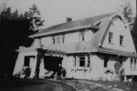
- The George and Jessie Haddon House is a symmetrical two-storey Dutch Colonial-style house with a side-gambrel roof and shed dormers. It is situated in the Burnaby Lake neighborhood in East Burnaby.
- Associated Dates
- 1922
- Formal Recognition
- Heritage Designation, Community Heritage Register
- Street View URL
- Google Maps Street View
- Repository
- Burnaby Heritage Planning
- Geographic Access
- Buckingham Avenue
- Associated Dates
- 1922
- Formal Recognition
- Heritage Designation, Community Heritage Register
- Enactment Type
- Bylaw No. 12064
- Enactment Date
- 19/06/2006
- Description
- The George and Jessie Haddon House is a symmetrical two-storey Dutch Colonial-style house with a side-gambrel roof and shed dormers. It is situated in the Burnaby Lake neighborhood in East Burnaby.
- Heritage Value
- Built in 1923, the George and Jessie Haddon House is a significant example of the romantic period revival styles that were popular during the period between the two World Wars. These traditionally styled homes reflected ongoing pride in past traditions but also recognized the modern ideals of economy and good design. At the time, houses displayed traditional and readily-identifiable historical styles as a hallmark of good taste. The use of the various Colonial Revival styles had gained new popularity during the 1920s, and this design could have originated in a residential pattern book, which were in wide circulation and used to expedite residential projects. This house displays the typical features of the Dutch Colonial style, imported from the eastern United States and relatively rare on the West Coast. The house originally featured an unusual porte-cochere with tapered supports, that indicated the growing importance of automobiles at the time. The house was built for George Samuel Haddon (1886-1971) and his wife Jessie (née Reade) Haddon, whom he married in 1915. George Haddon, who was born in British Columbia, was a prominent Vancouver figure and served as Secretary of the Vancouver General Hospital. Following Jessie's death, George Haddon was remarried to Alice Margaret Currie (1890-1951). The George and Jessie Haddon House is further valued for its connection with the continued development of the Burnaby Lake neighbourhood in the 1920s. The area was highly desirable to wealthy Vancouver and New Westminster residents because of its scenery, and easy access was provided by the British Columbia Electric Railway 'Burnaby Lake' interurban line, which opened in June 1911. The Haddon House illustrates the evolving nature of regional transportation and the growing communities made possible by increasing options for transportation. The house originally stood on a larger lot, and was relocated in 2006 to allow for subdivision and legal protection. The current owners restored the porte-cochere in 2014.
- Defining Elements
- Key elements that define the heritage character of the George and Jessie Haddon House include its: - location within the Burnaby Lake neighbourhood - residential form, scale and massing as expressed by its two-storey height and gambrel roof with shed dormers - rough-cast stucco cladding - Colonial Revival details such as the symmetrical façade and massing, and side-gambrel roof with shed dormers - additional exterior features such as an interior chimney, exposed purlins and window boxes supported on large projecting brackets - wooden front door with glazed insets - interior features including original staircase, and wooden door and window trim
- Historic Neighbourhood
- Burnaby Lake (Historic Neighbourhood)
- Planning Study Area
- Morley-Buckingham Area
- Builder
- William Dodson
- Function
- Primary Historic--Single Dwelling
- Cadastral Identifier
- P.I.D.026-745-127
- Boundaries
- The George and Jessie Haddon House is comprised of a single residential lot located at 5558 Buckingham Avenue, Burnaby.
- Area
- 1080
- Contributing Resource
- Building
- Ownership
- Private
- Documentation
- City of Burnaby Planning and Building Department, Heritage Site Files
- Street Address
- 5558 Buckingham Avenue
- Street View URL
- Google Maps Street View
Images
Rev. James Black Residence
https://search.heritageburnaby.ca/link/landmark632
- Repository
- Burnaby Heritage Planning
- Description
- Residential building.
- Associated Dates
- 1925
- Street View URL
- Google Maps Street View
- Repository
- Burnaby Heritage Planning
- Geographic Access
- Sussex Avenue
- Associated Dates
- 1925
- Description
- Residential building.
- Heritage Value
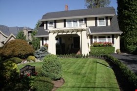
- This home was built as a retirement home for Baptist Missionary Reverend James Black and his family in 1925; the Black family resided in the home until the early 1970s. The Black Residence is a good example of the Period Revival movement that occurred between the two World Wars. At the time, it was considered good taste for a house to have an identifiable historical style. The Black Residence was likely designed by a local architect or built by a contractor using a pattern book plan, and the British Arts and Crafts influence was typical of many middle class homes of the period built in Burnaby. The house was originally located facing Sardis Street with a beautiful garden landscape that was lost when the house was relocated in 2005.
- Locality
- Central Park
- Historic Neighbourhood
- Central Park (Historic Neighbourhood)
- Planning Study Area
- Marlborough Area
- Area
- 639.00
- Contributing Resource
- Building
- Ownership
- Private
- Street Address
- 5688 Sussex Avenue
- Street View URL
- Google Maps Street View
Images
Nichols Chemical Company fonds
https://search.heritageburnaby.ca/link/museumdescription18755
- Repository
- Burnaby Village Museum
- Date
- 1906-1962
- Collection/Fonds
- Nichols Chemical Company fonds
- Description Level
- Fonds
- Physical Description
- 9 technical drawings
- Scope and Content
- Fonds consists of technical drawings of the Nichols Chemcial Company plant and machinery.
- Repository
- Burnaby Village Museum
- Collection/Fonds
- Nichols Chemical Company fonds
- Description Level
- Fonds
- Physical Description
- 9 technical drawings
- Scope and Content
- Fonds consists of technical drawings of the Nichols Chemcial Company plant and machinery.
- History
- In 1905 the Nichols Chemical Company, acid manufacturers based in Montreal, established their chemical plant on on a tract of land along Burrard Inlet, just east of the North Pacific Lumber Company. This company was later amalgamated and acquired by General Chemical and remains in operation on the original waterfront site. Many of workers at the Nichols Chemical Plant lived in bunkhouses in the community of Barnet including Japanese Canadian families who were employed there. Many of these families were laid off and forcibily removed during the internment of the Japanese in British Columbia during World War II.
- Creator
- Nichols Chemical Company Limited
- Accession Code
- BV998.23
- Date
- 1906-1962
- Media Type
- Technical Drawing
- Notes
- Title based on contents of fonds

