Narrow Results By
Person / Organization
- A. MacKenzie and Company Jubilee Store 2
- Babey, Beverley 1
- Bateman, Edwin W. 1
- Bateman, Marianne May
- Bingham, Alfred "Alf" 5
- Black, George
- Bossort, Kathy 2
- Bradbury, Dr. Bettina 11
- Brandrith, Martha Dorothy “Dot” Love 1
- British Columbia Auto Company 2
- British Columbia Electric Railway Company
- British Columbia Mills Timber and Trading Company 1

Interview with Marianne May Bateman February 22, 1978 - Track 3
https://search.heritageburnaby.ca/link/oralhistory190
- Repository
- City of Burnaby Archives
- Date Range
- 1880-1920
- Length
- 0:08:39
- Summary
- This portion of the interview pertains to Marianne May Bateman's father Edwin Bateman's history of first coming to Canada.
- Repository
- City of Burnaby Archives
- Summary
- This portion of the interview pertains to Marianne May Bateman's father Edwin Bateman's history of first coming to Canada.
- Date Range
- 1880-1920
- Photo Info
- Photograph of Edwin Wettenhall Bateman with his four daughters; Marianne May is sitting on a chair beside her father, [1903}. Item no. BV992.29.1
- Length
- 0:08:39
- Names
- Bateman, Edwin W.
- Interviewer
- Stevens, Colin
- Interview Date
- February 22, 1978
- Scope and Content
- Recording is of an interview with Marianne May "May" Bateman conducted by Colin Stevens, February 22, 1978. Major themes discussed are: Elworth.
- Biographical Notes
- May Bateman was born in 1894 in Portage LaPrairie, Manitoba, to Edwin Wettenhall Bateman and Cassie (Dale) Bateman. May's father, Edwin Bateman was born in 1859 in Sandbach, Cheshire, to James and Caroline Mary Wettenhall Bateman (their home in Sandbach was called Elworth Cottage). When he was 21, E.W. Bateman immigrated to Manitoba, Canada, where he met Catherine “Cassie” Dale, daughter of George and Sarah Gillon Dale. They were married in Portage La Prairie, Manitoba, on November 9, 1886. Edwin and Cassie had seven children: the eldest Edna Caroline Annie (Corner) born in 1889; George, Mamie (McWilliams) born in 1892; Marianne May “May” Bateman born in 1894; Jessie (Fox Kemp); Carey; and the youngest, Warren Stafford born in 1901. Cassie (Dale) Bateman died in Portage La Prairie in 1909. Edwin was transferred to Vancouver by the Canadian Pacific Railway where he married Cassie’s younger sister Mary Dale, born 1865, and moved his six children to Vancouver. The Bateman family first lived at 7th and Balsam in a large new house. It wasn’t until 1920 that they decided to move to the quieter atmosphere of the Burnaby Lake-Deer Lake area. By this time, Edwin Wettenhall Bateman was a retired CPR executive. He moved his wife and daughter May to Deer Lake and commissioned 'Elworth' house, designed by English-born and trained architect Enoch Evans. The house was completed by contractor William Dodson in 1922 and located at the site of what would become Burnaby Village Museum, 6501 Deer Lake Avenue. The Batemans lived in Burnaby for 15 years before moving back to Vancouver in May of 1935. Mary Bateman died July 5, 1935. Edwin Wettenhall Bateman died on November 25, 1957, at the age of 97. Marianne May Bateman died in 1990.
- Total Tracks
- 4
- Total Length
- 0:30:44
- Interviewee Name
- Bateman, Marianne May
- Collection/Fonds
- Burnaby Historical Society fonds
- Subseries
- Oral history subseries
- Media Type
- Sound Recording
- Web Notes
- Interview was digitized in 2010 allowing it to be accessible on Heritage Burnaby. The digitization project was initiated by the Community Heritage Commission with support from City of Burnaby Council and the BC History Digitization Program of the Irving K. Barber Learning Centre, University of British Columbia. It was recognized by the Heritage Society of BC with an award in 2012.
Images

Audio Tracks
Track three of interview with May Bateman
Track three of interview with May Bateman
https://search.heritageburnaby.ca/media/hpo/_Data/_Archives_Oral_Histories/_Unrestricted/MSS137-014-1/MSS137-014-1_Track_3.mp3![Survey and Subdivision plans in New Westminster District Group 1 – Burnaby
, [1908] thumbnail](/media/hpo/_Data/_BVM_Cartographic_Material/1977/1977_0093_0004a_001.jpg?width=280)
Survey and Subdivision plans in New Westminster District Group 1 – Burnaby
https://search.heritageburnaby.ca/link/museumdescription6973
- Repository
- Burnaby Village Museum
- Date
- [1908]
- Collection/Fonds
- Burnaby Village Museum Map collection
- Description Level
- File
- Physical Description
- 10 plans : blueprint ink on paper mounted on 2 sides of cardboard ; 76 cm x 102 cm
- Scope and Content
- Item consists of a large board of four New Westminster District Gp 1 - subdivision plans mounted on one side and six New Westminster District Gp 1 - subdivision plans mounted on the other side. Side A: 1. Blueprint "Plan / of - ReSubdivision / of / Lots 1-18 inclusive / Blocks 20 and 21 / in Sub…
- Repository
- Burnaby Village Museum
- Collection/Fonds
- Burnaby Village Museum Map collection
- Description Level
- File
- Physical Description
- 10 plans : blueprint ink on paper mounted on 2 sides of cardboard ; 76 cm x 102 cm
- Material Details
- Scales [between 1:792 and 1:4752]
- Index number on edge of board reads: "4"
- Scope and Content
- Item consists of a large board of four New Westminster District Gp 1 - subdivision plans mounted on one side and six New Westminster District Gp 1 - subdivision plans mounted on the other side. Side A: 1. Blueprint "Plan / of - ReSubdivision / of / Lots 1-18 inclusive / Blocks 20 and 21 / in Subdivision / of / Lot 53 -Gr.1 / New Westminster District" / "Subdivision Lot Numbers - Shown in Red". Plan is bordered by First Street / Jorgenson's Line / Fourth Avenue and Second Street with Fifith Avenue running through the centre. There is an index in the upper right corner of the plan. Planned is signed by "Peter Byrne" and "William R. Phillips" and dated July 28, 1908. (Geographic location: Burnaby) 2. Blueprint "Plan / of Subdivision / of / Lot 159 / and a Portion of Lot 158 / Group One / New Westminster District". Plan is bordered by Lots 96 and 97; South Wilson Street; North Arm Road and Lot 160 / Power House Road (Lot 155 A). B.C.E.R. Gilley Station is identified in the upper right corner of the plan. (Geographic location: Burnaby) 3. Blueprint plan identified as "Subdvs 10, L 88 and Lot 25, G. 1" Plan identifies Cumberland Street running from top to the bottom and a Ravine running alongside with the Jensen house, stable and barn. (Geographic location: Burnaby) 4. Blueprint Plan of "Lot 153. G. 1 /New Westminster District". Plan identifies the "New Westminster & Vancouver Tramway" and the "New Westminster and Vancouver Road" running through the plan of Lot 53. (Geographic location: Burnaby) Side B: 1. Blueprint plan of "Profile on Proposed North Rd. Diversion". 2. Blueprint plan (no title) showing wood lots north of Burnaby Lake and Brunette River and west of North Road. Various lots are identified as "Heavily Timbered" (Lot 57); "Splendid Fir and Cedar / Heavy Fir etc. / Fine Cedar" (Lots 143, 148); "Rough Light Timber," (Lot 56); "Some Fir and Cedar" (Lot 40). (Geographic location: Burnaby) 3. Blueprint "Plan / of Subdivision / of a Portion / of Lot 87, Gr.1 / New Westminster District". Plan is bordered by Burnaby Lake at the top and Hastings Road / Lot 86 at the bottom and Lot 90 to the east. "Albert J. Hill B.C.LotS." Annotation in ink reads: " J.A. Brownlee, B.C.L.S. / Subdivision / Map 1494 / Bd. 248". Plan is signed by "Peter Byrne, Reeve" (Geographic location: Burnaby) 4. Blueprint plan of Subdivisions along either side of Douglas Road including Lots 117; 119; 74; 80; 79 and 77. (Geographic location: Burnaby) 5. Blueprint "Plan / of / Subdivision of / Lot 27 / in Subdivision / of / Lot 30 / Group One / New Westminster District" Plan is bordered by Lot 26, Lot 28 and Hastings Rd. Lot 27 runs north of Edmonds Street. , "Albert J. Hill, B.C.LotS." (Geographic location: Burnaby) 6. Blueprint plan identified as a "Cultivated Orchard" including the names "W. Grace" and "G. Mead" located north of the North Arm Fraser River and west of "Twentieth Street_ City Boundary". Handwritten annotation in coloured pencil reads: "Portion of Lot 172" (Geographic location: Burnaby)
- Subjects
- Geographic Features - Forests
- Geographic Access
- Cumberland Street
- North Road
- Hastings Street
- Douglas Road
- Accession Code
- HV977.93.4
- Access Restriction
- No restrictions
- Reproduction Restriction
- No known restrictions
- Date
- [1908]
- Media Type
- Cartographic Material
- Historic Neighbourhood
- Burnaby Lake (Historic Neighbourhood)
- Fraser Arm (Historic Neighbourhood)
- Planning Study Area
- Douglas-Gilpin Area
- Burnaby Lake Area
- Scan Resolution
- 300
- Scale
- 72
- Notes
- Title based on contents of file
- Scale is measured in chains. (One chain equals 792 inches)
- The term "Lot" can also refer to a "District Lot”-
Images
![Survey and Subdivision plans in New Westminster District Group 1 – Burnaby
, [1908] thumbnail](/media/hpo/_Data/_BVM_Cartographic_Material/1977/1977_0093_0004a_001.jpg)

![Interurban tram at Steveston, [1908] (date original), copied [1988] thumbnail](/media/hpo/_Data/_BVM_Images/1988/1988_0007_0006_001.jpg?width=280)
Interurban tram at Steveston
https://search.heritageburnaby.ca/link/museumdescription88
- Repository
- Burnaby Village Museum
- Date
- [1908] (date original), copied [1988]
- Collection/Fonds
- Burnaby Village Museum Photograph collection
- Description Level
- Item
- Physical Description
- 1 photograph : b&w print ; 19.5 x 24.5 cm
- Scope and Content
- Photograph of British Columbia Electric Railway Company interurban tram "RICHMOND" at Steveston (the tram would later be called no. 1205). The tram is bound for Vancouver and loaded with passengers. Three men (two wearing conductor's uniforms) are standing near the front door of the tram, facing th…
- Repository
- Burnaby Village Museum
- Collection/Fonds
- Burnaby Village Museum Photograph collection
- Description Level
- Item
- Physical Description
- 1 photograph : b&w print ; 19.5 x 24.5 cm
- Scope and Content
- Photograph of British Columbia Electric Railway Company interurban tram "RICHMOND" at Steveston (the tram would later be called no. 1205). The tram is bound for Vancouver and loaded with passengers. Three men (two wearing conductor's uniforms) are standing near the front door of the tram, facing the camera.
- Subjects
- Transportation - Electric Railroads
- Accession Code
- BV988.7.6
- Access Restriction
- No restrictions
- Reproduction Restriction
- No known restrictions
- Date
- [1908] (date original), copied [1988]
- Media Type
- Photograph
- Scan Resolution
- 600
- Scan Date
- 2024-04-09
- Scale
- 100
- Notes
- Title based on contents of photograph
- Note on verso of photograph reads: "RICHMOND" (later # 1205) at Steveston about 1908" and "H. EWERT photo [mailing address follows]"
Images
![Interurban tram at Steveston, [1908] (date original), copied [1988] thumbnail](/media/hpo/_Data/_BVM_Images/1988/1988_0007_0006_001.jpg)
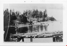
Waterfront Looking west from George Black's
https://search.heritageburnaby.ca/link/museumdescription4775
- Repository
- Burnaby Village Museum
- Date
- 1890-1915
- Collection/Fonds
- Burnaby Village Museum Photograph collection
- Description Level
- Item
- Physical Description
- 1 photograph : b&w ; 8.5 x 12.5 cm ; copy print
- Scope and Content
- Waterfront scene with land on left and water on right. Wooden dock/jetty in foreground. From left to right along the shore there are people wading, a maple tree, a slaughterhouse, a cattle yard, boating bathers, fishing. Trees and houses in background.
- Repository
- Burnaby Village Museum
- Collection/Fonds
- Burnaby Village Museum Photograph collection
- Description Level
- Item
- Physical Description
- 1 photograph : b&w ; 8.5 x 12.5 cm ; copy print
- Material Details
- "Looking west from George Black's. Wading. Maple Tree. Marine ways. Saughterhouse. Cattleyard. Boating Bathers. Fishing. […]" written in black ink on bottom front of photograph. "Columbian files 1971" written on verso in black pen. "996" stamped on back.
- Scope and Content
- Waterfront scene with land on left and water on right. Wooden dock/jetty in foreground. From left to right along the shore there are people wading, a maple tree, a slaughterhouse, a cattle yard, boating bathers, fishing. Trees and houses in background.
- History
- Part of a set of photographs from the Columbian Newspaper, which operated out of New Westminster under this name starting in 1900 until its dissolution in 1988. Photographs found in the collection of the Burnaby Village are dated 1971. George Black (1831-1896). He was born in Aberdeen Scotland, and went to California, then to the Cariboo during the gold rush. He eventually settled on Hastings Street, and was well known in the surroundings of Vancouver.
- Other Title Information
- title based on content and note on front of photograph
- Names
- Black, George
- Accession Code
- BV018.19.1
- Access Restriction
- No restrictions
- Reproduction Restriction
- May be restricted by third party rights
- Date
- 1890-1915
- Media Type
- Photograph
- Scan Resolution
- 600
- Scan Date
- 24-04-2018
Images
