Narrow Results By
Subject
- Advertising Medium - Signs and Signboards 14
- Agriculture - Crops 1
- Agriculture - Farms 3
- Agriculture - Fruit and Berries 1
- Animals - Dogs 1
- Buildings - Commercial - Stores 2
- Buildings - Residential - Houses 2
- Ceremonies - Weddings 1
- Construction - Road Construction 1
- Construction Tools and Equipment 1
- Exhibitions - Agricultural 1
- Furniture 2
Person / Organization
- Canada Way Food Market 2
- Central Park Agricultural Association and Farmers' Institute 1
- F R Stewart and Company Limited 1
- Hill, Arthur Claude 2
- Hill, Bernard R. 1
- Hill, Francis Leonard "Frank" 1
- Hill, Kenneth 1
- Hill, Minard Gerald "Gerry" 1
- Peers, Katherine Maude Hill "Kitty" 2
- Rowe, Arthur 2
- Rowe, Winnifred L. "Winnie" Hill 3
- Sprott, Helen Louise Faith Nicholls 2
Annual Exhibition
https://search.heritageburnaby.ca/link/museumdescription1170
- Repository
- Burnaby Village Museum
- Date
- September 1908
- Collection/Fonds
- Burnaby Village Museum Photograph collection
- Description Level
- Item
- Physical Description
- 1 photograph : sepia ; 11.5 x 15.5 cm mounted on card 20 x 25 cm
- Scope and Content
- Photograph of fruit displays at the Central Park Annual Exhibition which took place from September 17 to 18, 1908. The fruits in crates or plates are displayed on tables. Also visible in other sections of the room are floral displays and baked goods. Some of the wooden crates on the table in the fo…
- Repository
- Burnaby Village Museum
- Collection/Fonds
- Burnaby Village Museum Photograph collection
- Description Level
- Item
- Physical Description
- 1 photograph : sepia ; 11.5 x 15.5 cm mounted on card 20 x 25 cm
- Scope and Content
- Photograph of fruit displays at the Central Park Annual Exhibition which took place from September 17 to 18, 1908. The fruits in crates or plates are displayed on tables. Also visible in other sections of the room are floral displays and baked goods. Some of the wooden crates on the table in the foreground of the photograph include insignia: "Grown & Packed by F.R. Stewart & Co. Central Park B.C.".
- Geographic Access
- Central Park
- Accession Code
- BV993.45.2
- Access Restriction
- No restrictions
- Reproduction Restriction
- No known restrictions
- Date
- September 1908
- Media Type
- Photograph
- Related Material
- For another print of the same image, see BV998.30.1
- Scan Resolution
- 600
- Scan Date
- 2024-04-23
- Photographer
- Bullen, Harry Elder
- Notes
- Continuation of title: "... CENTRAL PARK/ SEPT 17-18. '08."
- Photographer's annotation reads: "BULLEN PHOTO"
Images
Burnaby's COVID-19 drive thru testing site
https://search.heritageburnaby.ca/link/museumdescription15374
- Repository
- Burnaby Village Museum
- Date
- 5 Apr. 2020
- Collection/Fonds
- Burnaby Village Museum COVID-19 collection
- Description Level
- Item
- Physical Description
- 1 photograph (jpg)
- Scope and Content
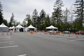
- Photograph of the COVID-19 drive thru testing site in Central Park parking lot in Burnaby. Orange traffic posts and wayfinding signs are set up in the parking lot.
- Repository
- Burnaby Village Museum
- Collection/Fonds
- Burnaby Village Museum COVID-19 collection
- Description Level
- Item
- Physical Description
- 1 photograph (jpg)
- Scope and Content
- Photograph of the COVID-19 drive thru testing site in Central Park parking lot in Burnaby. Orange traffic posts and wayfinding signs are set up in the parking lot.
- Subjects
- Advertising Medium - Signs and Signboards
- Geographic Features - Parks
- Public Services - Health Services
- Pandemics - COVID-19
- Geographic Access
- Central Park
- Imperial Street
- Accession Code
- BV021.2.39
- Access Restriction
- No restrictions
- Reproduction Restriction
- May be restricted by third party rights
- Date
- 5 Apr. 2020
- Media Type
- Photograph
- Historic Neighbourhood
- Central Park (Historic Neighbourhood)
- Planning Study Area
- Maywood Area
- Notes
- Title based on contents of photograph
Images
Burnaby's COVID-19 drive thru testing site
https://search.heritageburnaby.ca/link/museumdescription15375
- Repository
- Burnaby Village Museum
- Date
- 5 Apr. 2020
- Collection/Fonds
- Burnaby Village Museum COVID-19 collection
- Description Level
- Item
- Physical Description
- 1 photograph (jpg)
- Scope and Content
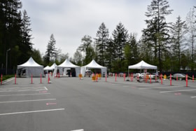
- Photograph of the COVID-19 drive thru testing site in Central Park parking lot in Burnaby. Orange traffic posts, wayfinding signs and white tents are set up in the parking lot.
- Repository
- Burnaby Village Museum
- Collection/Fonds
- Burnaby Village Museum COVID-19 collection
- Description Level
- Item
- Physical Description
- 1 photograph (jpg)
- Scope and Content
- Photograph of the COVID-19 drive thru testing site in Central Park parking lot in Burnaby. Orange traffic posts, wayfinding signs and white tents are set up in the parking lot.
- Subjects
- Advertising Medium - Signs and Signboards
- Geographic Features - Parks
- Public Services - Health Services
- Pandemics - COVID-19
- Geographic Access
- Central Park
- Imperial Street
- Accession Code
- BV021.2.40
- Access Restriction
- No restrictions
- Reproduction Restriction
- May be restricted by third party rights
- Date
- 5 Apr. 2020
- Media Type
- Photograph
- Historic Neighbourhood
- Central Park (Historic Neighbourhood)
- Planning Study Area
- Maywood Area
- Notes
- Title based on contents of photograph
Images
Burnaby's COVID-19 drive thru testing site
https://search.heritageburnaby.ca/link/museumdescription15376
- Repository
- Burnaby Village Museum
- Date
- 5 Apr. 2020
- Collection/Fonds
- Burnaby Village Museum COVID-19 collection
- Description Level
- Item
- Physical Description
- 1 photograph (jpg)
- Scope and Content
- Photograph of the COVID-19 drive thru testing site in Central Park parking lot in Burnaby. Orange traffic posts, wayfinding signs and white tents are set up in the parking lot.
- Repository
- Burnaby Village Museum
- Collection/Fonds
- Burnaby Village Museum COVID-19 collection
- Description Level
- Item
- Physical Description
- 1 photograph (jpg)
- Scope and Content
- Photograph of the COVID-19 drive thru testing site in Central Park parking lot in Burnaby. Orange traffic posts, wayfinding signs and white tents are set up in the parking lot.
- Subjects
- Advertising Medium - Signs and Signboards
- Geographic Features - Parks
- Public Services - Health Services
- Pandemics - COVID-19
- Geographic Access
- Central Park
- Imperial Street
- Accession Code
- BV021.2.41
- Access Restriction
- No restrictions
- Reproduction Restriction
- May be restricted by third party rights
- Date
- 5 Apr. 2020
- Media Type
- Photograph
- Historic Neighbourhood
- Central Park (Historic Neighbourhood)
- Planning Study Area
- Maywood Area
- Notes
- Title based on contents of photograph
Images
Burnaby's COVID-19 drive thru testing site
https://search.heritageburnaby.ca/link/museumdescription15377
- Repository
- Burnaby Village Museum
- Date
- 5 Apr. 2020
- Collection/Fonds
- Burnaby Village Museum COVID-19 collection
- Description Level
- Item
- Physical Description
- 1 photograph (jpg)
- Scope and Content
- Photograph of the COVID-19 drive thru testing site in Central Park parking lot in Burnaby. Orange traffic posts, wayfinding signs and white tents are set up in the parking lot.
- Repository
- Burnaby Village Museum
- Collection/Fonds
- Burnaby Village Museum COVID-19 collection
- Description Level
- Item
- Physical Description
- 1 photograph (jpg)
- Scope and Content
- Photograph of the COVID-19 drive thru testing site in Central Park parking lot in Burnaby. Orange traffic posts, wayfinding signs and white tents are set up in the parking lot.
- Subjects
- Advertising Medium - Signs and Signboards
- Geographic Features - Parks
- Public Services - Health Services
- Pandemics - COVID-19
- Geographic Access
- Central Park
- Imperial Street
- Accession Code
- BV021.2.42
- Access Restriction
- No restrictions
- Reproduction Restriction
- May be restricted by third party rights
- Date
- 5 Apr. 2020
- Media Type
- Photograph
- Historic Neighbourhood
- Central Park (Historic Neighbourhood)
- Planning Study Area
- Maywood Area
- Notes
- Title based on contents of photograph
Images
Burnaby's COVID-19 drive thru testing site
https://search.heritageburnaby.ca/link/museumdescription15378
- Repository
- Burnaby Village Museum
- Date
- 5 Apr. 2020
- Collection/Fonds
- Burnaby Village Museum COVID-19 collection
- Description Level
- Item
- Physical Description
- 1 photograph (jpg)
- Scope and Content
- Photograph of the COVID-19 drive thru testing site in Central Park parking lot in Burnaby. Orange traffic posts, wayfinding signs and white tents are set up in the parking lot.
- Repository
- Burnaby Village Museum
- Collection/Fonds
- Burnaby Village Museum COVID-19 collection
- Description Level
- Item
- Physical Description
- 1 photograph (jpg)
- Scope and Content
- Photograph of the COVID-19 drive thru testing site in Central Park parking lot in Burnaby. Orange traffic posts, wayfinding signs and white tents are set up in the parking lot.
- Subjects
- Advertising Medium - Signs and Signboards
- Geographic Features - Parks
- Public Services - Health Services
- Pandemics - COVID-19
- Geographic Access
- Central Park
- Imperial Street
- Accession Code
- BV021.2.43
- Access Restriction
- No restrictions
- Reproduction Restriction
- May be restricted by third party rights
- Date
- 5 Apr. 2020
- Media Type
- Photograph
- Historic Neighbourhood
- Central Park (Historic Neighbourhood)
- Planning Study Area
- Maywood Area
- Notes
- Title based on contents of photograph
Images
Burnaby's COVID-19 drive thru testing site
https://search.heritageburnaby.ca/link/museumdescription15379
- Repository
- Burnaby Village Museum
- Date
- 5 Apr. 2020
- Collection/Fonds
- Burnaby Village Museum COVID-19 collection
- Description Level
- Item
- Physical Description
- 1 photograph (jpg)
- Scope and Content
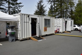
- Photograph of the COVID-19 drive thru testing site in Central Park parking lot in Burnaby. Orange traffic posts, wayfinding signs, white tents and white buildings converted from shipping containers are set up in the parking lot.
- Repository
- Burnaby Village Museum
- Collection/Fonds
- Burnaby Village Museum COVID-19 collection
- Description Level
- Item
- Physical Description
- 1 photograph (jpg)
- Scope and Content
- Photograph of the COVID-19 drive thru testing site in Central Park parking lot in Burnaby. Orange traffic posts, wayfinding signs, white tents and white buildings converted from shipping containers are set up in the parking lot.
- Subjects
- Advertising Medium - Signs and Signboards
- Geographic Features - Parks
- Public Services - Health Services
- Pandemics - COVID-19
- Geographic Access
- Central Park
- Imperial Street
- Accession Code
- BV021.2.44
- Access Restriction
- No restrictions
- Reproduction Restriction
- May be restricted by third party rights
- Date
- 5 Apr. 2020
- Media Type
- Photograph
- Historic Neighbourhood
- Central Park (Historic Neighbourhood)
- Planning Study Area
- Maywood Area
- Notes
- Title based on contents of photograph
Images
Burnaby's COVID-19 drive thru testing site
https://search.heritageburnaby.ca/link/museumdescription15380
- Repository
- Burnaby Village Museum
- Date
- 5 Apr. 2020
- Collection/Fonds
- Burnaby Village Museum COVID-19 collection
- Description Level
- Item
- Physical Description
- 1 photograph (jpg)
- Scope and Content
- Photograph of the COVID-19 drive thru testing site in Central Park parking lot in Burnaby. Orange traffic posts, wayfinding signs and white tents are set up in the parking lot.
- Repository
- Burnaby Village Museum
- Collection/Fonds
- Burnaby Village Museum COVID-19 collection
- Description Level
- Item
- Physical Description
- 1 photograph (jpg)
- Scope and Content
- Photograph of the COVID-19 drive thru testing site in Central Park parking lot in Burnaby. Orange traffic posts, wayfinding signs and white tents are set up in the parking lot.
- Subjects
- Advertising Medium - Signs and Signboards
- Geographic Features - Parks
- Public Services - Health Services
- Pandemics - COVID-19
- Geographic Access
- Central Park
- Imperial Street
- Accession Code
- BV021.2.45
- Access Restriction
- No restrictions
- Reproduction Restriction
- May be restricted by third party rights
- Date
- 5 Apr. 2020
- Media Type
- Photograph
- Historic Neighbourhood
- Central Park (Historic Neighbourhood)
- Planning Study Area
- Maywood Area
- Notes
- Title based on contents of photograph
Images
Burnaby's COVID-19 drive thru testing site
https://search.heritageburnaby.ca/link/museumdescription15381
- Repository
- Burnaby Village Museum
- Date
- 5 Apr. 2020
- Collection/Fonds
- Burnaby Village Museum COVID-19 collection
- Description Level
- Item
- Physical Description
- 1 photograph (jpg)
- Scope and Content
- Photograph of the COVID-19 drive thru testing site in Central Park parking lot in Burnaby. Orange traffic posts, wayfinding signs and white tents are set up in the parking lot.
- Repository
- Burnaby Village Museum
- Collection/Fonds
- Burnaby Village Museum COVID-19 collection
- Description Level
- Item
- Physical Description
- 1 photograph (jpg)
- Scope and Content
- Photograph of the COVID-19 drive thru testing site in Central Park parking lot in Burnaby. Orange traffic posts, wayfinding signs and white tents are set up in the parking lot.
- Subjects
- Advertising Medium - Signs and Signboards
- Geographic Features - Parks
- Public Services - Health Services
- Pandemics - COVID-19
- Geographic Access
- Central Park
- Imperial Street
- Accession Code
- BV021.2.46
- Access Restriction
- No restrictions
- Reproduction Restriction
- May be restricted by third party rights
- Date
- 5 Apr. 2020
- Media Type
- Photograph
- Historic Neighbourhood
- Central Park (Historic Neighbourhood)
- Planning Study Area
- Maywood Area
- Notes
- Title based on contents of photograph
Images
Burnaby's COVID-19 drive thru testing site
https://search.heritageburnaby.ca/link/museumdescription15382
- Repository
- Burnaby Village Museum
- Date
- 5 Apr. 2020
- Collection/Fonds
- Burnaby Village Museum COVID-19 collection
- Description Level
- Item
- Physical Description
- 1 photograph (jpg)
- Scope and Content
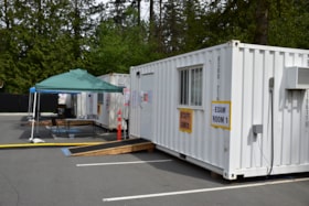
- Photograph of the COVID-19 drive thru testing site in Central Park parking lot in Burnaby. White shipping container buildings have been set up in the parking lot.
- Repository
- Burnaby Village Museum
- Collection/Fonds
- Burnaby Village Museum COVID-19 collection
- Description Level
- Item
- Physical Description
- 1 photograph (jpg)
- Scope and Content
- Photograph of the COVID-19 drive thru testing site in Central Park parking lot in Burnaby. White shipping container buildings have been set up in the parking lot.
- Subjects
- Advertising Medium - Signs and Signboards
- Geographic Features - Parks
- Public Services - Health Services
- Pandemics - COVID-19
- Geographic Access
- Central Park
- Imperial Street
- Accession Code
- BV021.2.47
- Access Restriction
- No restrictions
- Reproduction Restriction
- May be restricted by third party rights
- Date
- 5 Apr. 2020
- Media Type
- Photograph
- Historic Neighbourhood
- Central Park (Historic Neighbourhood)
- Planning Study Area
- Maywood Area
- Notes
- Title based on contents of photograph
Images
Burnaby's COVID-19 drive thru testing site
https://search.heritageburnaby.ca/link/museumdescription15383
- Repository
- Burnaby Village Museum
- Date
- 5 Apr. 2020
- Collection/Fonds
- Burnaby Village Museum COVID-19 collection
- Description Level
- Item
- Physical Description
- 1 photograph (jpg)
- Scope and Content
- Photograph of the COVID-19 drive thru testing site in Central Park parking lot in Burnaby. White shipping container buildings have been set up in the parking lot.
- Repository
- Burnaby Village Museum
- Collection/Fonds
- Burnaby Village Museum COVID-19 collection
- Description Level
- Item
- Physical Description
- 1 photograph (jpg)
- Scope and Content
- Photograph of the COVID-19 drive thru testing site in Central Park parking lot in Burnaby. White shipping container buildings have been set up in the parking lot.
- Subjects
- Advertising Medium - Signs and Signboards
- Geographic Features - Parks
- Public Services - Health Services
- Pandemics - COVID-19
- Geographic Access
- Central Park
- Imperial Street
- Accession Code
- BV021.2.48
- Access Restriction
- No restrictions
- Reproduction Restriction
- May be restricted by third party rights
- Date
- 5 Apr. 2020
- Media Type
- Photograph
- Historic Neighbourhood
- Central Park (Historic Neighbourhood)
- Planning Study Area
- Maywood Area
- Notes
- Title based on contents of photograph
Images
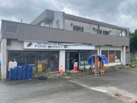
Canada Way Food Market and Toy residence
https://search.heritageburnaby.ca/link/museumdescription20350
- Repository
- Burnaby Village Museum
- Date
- 13 Jun. 2023
- Collection/Fonds
- Harry Toy fonds
- Description Level
- Item
- Physical Description
- 1 photograph (tiff) : col.
- Scope and Content
- Photograph of the exterior of Canada Way Food Market building and Toy family residence (above) located at 4694 Canada Way. Blue plastic food crates, store racks and car tires are in the parking area in front of the store. The food market closed in 2010.
- Repository
- Burnaby Village Museum
- Collection/Fonds
- Harry Toy fonds
- Series
- Harry Toy photographs series
- Description Level
- Item
- Physical Description
- 1 photograph (tiff) : col.
- Scope and Content
- Photograph of the exterior of Canada Way Food Market building and Toy family residence (above) located at 4694 Canada Way. Blue plastic food crates, store racks and car tires are in the parking area in front of the store. The food market closed in 2010.
- Subjects
- Buildings - Commercial - Stores
- Names
- Canada Way Food Market
- Geographic Access
- Canada Way
- Street Address
- 4694 Canada Way
- Accession Code
- BV023.25.2
- Access Restriction
- No restrictions
- Reproduction Restriction
- No known restrictions
- Date
- 13 Jun. 2023
- Media Type
- Photograph
- Related Material
- See also BV023.16.19 - Interview with Harry Toy, Beverley Babey and Christina Toy
- For associated artifacts from Canada Way Food Market see Accession BV023.17
- Scan Date
- 2023-06-13
- Photographer
- Petrusa, Kate
- Notes
- Title based on contents of photograph
Images
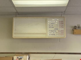
Cigarette price sign inside of Canada Way Food Market
https://search.heritageburnaby.ca/link/museumdescription20349
- Repository
- Burnaby Village Museum
- Date
- 13 Jun. 2023
- Collection/Fonds
- Harry Toy fonds
- Description Level
- Item
- Physical Description
- 1 photograph (jpg) : col.
- Scope and Content
- Photograph of cigarette price display sign hanging from ceiling inside of the Canada Way Food Market located at 4694 Canada Way, Burnaby. Boxes are visible beneath the sign. The food market closed in 2010.
- Repository
- Burnaby Village Museum
- Collection/Fonds
- Harry Toy fonds
- Series
- Harry Toy photographs series
- Description Level
- Item
- Physical Description
- 1 photograph (jpg) : col.
- Scope and Content
- Photograph of cigarette price display sign hanging from ceiling inside of the Canada Way Food Market located at 4694 Canada Way, Burnaby. Boxes are visible beneath the sign. The food market closed in 2010.
- Subjects
- Buildings - Commercial - Stores
- Names
- Canada Way Food Market
- Geographic Access
- Canada Way
- Street Address
- 4694 Canada Way
- Accession Code
- BV023.25.1
- Access Restriction
- No restrictions
- Reproduction Restriction
- No known restrictions
- Date
- 13 Jun. 2023
- Media Type
- Photograph
- Related Material
- BV023.16.19 - Interview with Harry Toy, Beverley Babey and Christina Toy
- BV023.17.3 - Cigarette price display sign
- For associated artifacts from Canada Way Food Market see Accession BV023.17
- Scan Date
- 2023-06-13
- Photographer
- Petrusa, Kate
- Notes
- Title based on contents of photograph
- The sign was donated to the Burnaby Village Museum in 2023
Images
Cleared land
https://search.heritageburnaby.ca/link/museumdescription462
- Repository
- Burnaby Village Museum
- Date
- [190-](date of original), copied 1978
- Collection/Fonds
- Burnaby Village Museum Photograph collection
- Description Level
- Item
- Physical Description
- 1 photograph : b&w ; 20.2 x 25.2 cm print
- Scope and Content
- Photograph of the cleared land which appears to be the Sprott family property. There are stumps and felled trees on the lot. Across a small dirt road and behind a wooden fence, the Haszard house is visible to the extreme right of the photograph.
- Repository
- Burnaby Village Museum
- Collection/Fonds
- Burnaby Village Museum Photograph collection
- Description Level
- Item
- Physical Description
- 1 photograph : b&w ; 20.2 x 25.2 cm print
- Scope and Content
- Photograph of the cleared land which appears to be the Sprott family property. There are stumps and felled trees on the lot. Across a small dirt road and behind a wooden fence, the Haszard house is visible to the extreme right of the photograph.
- Subjects
- Land Clearing
- Plants - Trees
- Geographic Access
- Canada Way
- Accession Code
- HV978.1.16
- Access Restriction
- No restrictions
- Reproduction Restriction
- No known restrictions
- Date
- [190-](date of original), copied 1978
- Media Type
- Photograph
- Historic Neighbourhood
- Burnaby Lake (Historic Neighbourhood)
- Scan Resolution
- 600
- Scan Date
- 2023-08-01
- Notes
- Title based on contents of photograph
Images
Clearing Douglas Road
https://search.heritageburnaby.ca/link/museumdescription560
- Repository
- Burnaby Village Museum
- Date
- [190-?] (date of original), copied 1977
- Collection/Fonds
- Burnaby Village Museum Photograph collection
- Description Level
- Item
- Physical Description
- 1 photograph : b&w ; 20.2 x 25.2 cm print
- Scope and Content
- Photograph of men in work clothes clearing Doulgas Road. A group of men to the right side of the photograph have shovels in their hands and are clearing rocks from the road. There is a small girl in a blouse and skirt standing beside two horses pulling a cart. Behind her is a group of men in wor…
- Repository
- Burnaby Village Museum
- Collection/Fonds
- Burnaby Village Museum Photograph collection
- Description Level
- Item
- Physical Description
- 1 photograph : b&w ; 20.2 x 25.2 cm print
- Scope and Content
- Photograph of men in work clothes clearing Doulgas Road. A group of men to the right side of the photograph have shovels in their hands and are clearing rocks from the road. There is a small girl in a blouse and skirt standing beside two horses pulling a cart. Behind her is a group of men in work clothes as well. There is fenced land to the right of the photograph, and electric power poles and trees line both sides of the road. The accession register and inscription on the photograph identify this as Douglas Road (later renamed in part Canada Way). An annotation on the back of the photo reads: "Working on Douglas Road on hill above Burnaby Lake. No Date."
- Geographic Access
- Douglas Road
- Canada Way
- Accession Code
- HV977.99.2
- Access Restriction
- No restrictions
- Reproduction Restriction
- May be restricted by third party rights
- Date
- [190-?] (date of original), copied 1977
- Media Type
- Photograph
- Historic Neighbourhood
- Burnaby Lake (Historic Neighbourhood)
- Scan Resolution
- 600
- Scan Date
- 2023-07-11
- Notes
- Title based on contents of photograph
Images
Couple sitting on the steps
https://search.heritageburnaby.ca/link/museumdescription598
- Repository
- Burnaby Village Museum
- Date
- [190-?] (date of original), copied 1977
- Collection/Fonds
- Burnaby Village Museum Photograph collection
- Description Level
- Item
- Physical Description
- 1 photograph : b&w ; 20.2 x 25.2 cm print
- Scope and Content
- Photograph of a young couple sitting together on the steps to a house that appears to be Bernard Hill home on Douglas Road near Deer Lake. The couple appears to be Arthur Rowe and his wife Winnie Hill Rowe (daughter of Bernard Hill). There is a person standing on the patio in the background.
- Repository
- Burnaby Village Museum
- Collection/Fonds
- Burnaby Village Museum Photograph collection
- Description Level
- Item
- Physical Description
- 1 photograph : b&w ; 20.2 x 25.2 cm print
- Scope and Content
- Photograph of a young couple sitting together on the steps to a house that appears to be Bernard Hill home on Douglas Road near Deer Lake. The couple appears to be Arthur Rowe and his wife Winnie Hill Rowe (daughter of Bernard Hill). There is a person standing on the patio in the background.
- Geographic Access
- Canada Way
- Street Address
- 4990 Canada Way
- Accession Code
- HV977.123.4
- Access Restriction
- No restrictions
- Reproduction Restriction
- No known restrictions
- Date
- [190-?] (date of original), copied 1977
- Media Type
- Photograph
- Historic Neighbourhood
- Burnaby Lake (Historic Neighbourhood)
- Planning Study Area
- Douglas-Gilpin Area
- Scan Resolution
- 600
- Scan Date
- 2023-07-18
- Notes
- Title based on contents of photograph
Images
Gathering by a house
https://search.heritageburnaby.ca/link/museumdescription622
- Repository
- Burnaby Village Museum
- Date
- [190-?] (date of original), copied 1977
- Collection/Fonds
- Burnaby Village Museum Photograph collection
- Description Level
- Item
- Physical Description
- 1 photograph : b&w ; 20.2 x 25.2 cm print
- Scope and Content
- Photograph of a large gathering of people, men, women and children, in fine dresses and suits by a house with a picket fence. An accompanying note in the accession file identifies the photograph as taken on "sister's wedding" (possibly Winnie Hill Rowe) waiting to go into reception at B.R. Hill's (…
- Repository
- Burnaby Village Museum
- Collection/Fonds
- Burnaby Village Museum Photograph collection
- Description Level
- Item
- Physical Description
- 1 photograph : b&w ; 20.2 x 25.2 cm print
- Scope and Content
- Photograph of a large gathering of people, men, women and children, in fine dresses and suits by a house with a picket fence. An accompanying note in the accession file identifies the photograph as taken on "sister's wedding" (possibly Winnie Hill Rowe) waiting to go into reception at B.R. Hill's (Bernard Richard Hill) house.
- Subjects
- Ceremonies - Weddings
- Geographic Access
- Douglas Road
- Canada Way
- Street Address
- 4990 Canada Way
- Accession Code
- HV977.123.28
- Access Restriction
- No restrictions
- Reproduction Restriction
- No known restrictions
- Date
- [190-?] (date of original), copied 1977
- Media Type
- Photograph
- Historic Neighbourhood
- Burnaby Lake (Historic Neighbourhood)
- Planning Study Area
- Douglas-Gilpin Area
- Scan Resolution
- 600
- Scan Date
- 2023-07-25
- Notes
- Title based on contents of photograph
Images
Haszard house
https://search.heritageburnaby.ca/link/museumdescription449
- Repository
- Burnaby Village Museum
- Date
- [190-](date of original), copied 1978
- Collection/Fonds
- Burnaby Village Museum Photograph collection
- Description Level
- Item
- Physical Description
- 1 photograph : b&w ; 20.2 x 25.2 cm print
- Scope and Content
- Photograph of a house in a clearing just on the outskirts of densely wooded area. There is a wooden fence around the property, and in front of the house is a dirt road. There are small piles of logs along the road side. An earlier catalogue record identifies this house as the Haszard house that was…
- Repository
- Burnaby Village Museum
- Collection/Fonds
- Burnaby Village Museum Photograph collection
- Description Level
- Item
- Physical Description
- 1 photograph : b&w ; 20.2 x 25.2 cm print
- Scope and Content
- Photograph of a house in a clearing just on the outskirts of densely wooded area. There is a wooden fence around the property, and in front of the house is a dirt road. There are small piles of logs along the road side. An earlier catalogue record identifies this house as the Haszard house that was located across the street from the property of the Sprott Farm. The photograph was taken from Douglas Road (later renamed in part Canada Way). It is also noted that the Sprott family lived in the Haszard house while their home, named "Dovecote" was being completed.
- Geographic Access
- Douglas Road
- Canada Way
- Accession Code
- HV978.1.3
- Access Restriction
- No restrictions
- Reproduction Restriction
- No known restrictions
- Date
- [190-](date of original), copied 1978
- Media Type
- Photograph
- Historic Neighbourhood
- Burnaby Lake (Historic Neighbourhood)
- Scan Resolution
- 600
- Scan Date
- 2023-07-25
- Notes
- Title based on contents of photograph
Images
Having tea on the porch
https://search.heritageburnaby.ca/link/museumdescription619
- Repository
- Burnaby Village Museum
- Date
- [190-] (date of original), copied 1977
- Collection/Fonds
- Burnaby Village Museum Photograph collection
- Description Level
- Item
- Physical Description
- 1 photograph : b&w ; 20.2 x 25.2 cm print
- Scope and Content
- Photograph of a family having tea on the porch.There are two tables with tea and snacks, and some wicker chairs. An accompanying note in the accession file identifies the elderly man sitting on the rail as B.R. (Bernard Richard) Hill, and the man and the boy by the other side of the rail as Claude …
- Repository
- Burnaby Village Museum
- Collection/Fonds
- Burnaby Village Museum Photograph collection
- Description Level
- Item
- Physical Description
- 1 photograph : b&w ; 20.2 x 25.2 cm print
- Scope and Content
- Photograph of a family having tea on the porch.There are two tables with tea and snacks, and some wicker chairs. An accompanying note in the accession file identifies the elderly man sitting on the rail as B.R. (Bernard Richard) Hill, and the man and the boy by the other side of the rail as Claude (son of Bernard Hill) and his son Kenneth. One of the women, unclear which one, is identified as "Maude's mother."
- Subjects
- Furniture
- Geographic Access
- Canada Way
- Street Address
- 4990 Canada Way
- Accession Code
- HV977.123.25
- Access Restriction
- No restrictions
- Reproduction Restriction
- No known restrictions
- Date
- [190-] (date of original), copied 1977
- Media Type
- Photograph
- Historic Neighbourhood
- Burnaby Lake (Historic Neighbourhood)
- Planning Study Area
- Douglas-Gilpin Area
- Scan Resolution
- 600
- Scan Date
- 2023-07-25
- Notes
- Title based on contents of photograph
Images
Having tea on the porch
https://search.heritageburnaby.ca/link/museumdescription620
- Repository
- Burnaby Village Museum
- Date
- [190-] (date of original), copied 1977
- Collection/Fonds
- Burnaby Village Museum Photograph collection
- Description Level
- Item
- Physical Description
- 1 photograph : b&w ; 20.2 x 25.2 cm print
- Scope and Content
- Photograph of a family having tea on a porch. There are three women and a young man who is sitting on a wicker chair. The women are pouring tea by the table. The location has been identified as the Bernard Hill family veranda.
- Repository
- Burnaby Village Museum
- Collection/Fonds
- Burnaby Village Museum Photograph collection
- Description Level
- Item
- Physical Description
- 1 photograph : b&w ; 20.2 x 25.2 cm print
- Scope and Content
- Photograph of a family having tea on a porch. There are three women and a young man who is sitting on a wicker chair. The women are pouring tea by the table. The location has been identified as the Bernard Hill family veranda.
- Subjects
- Furniture
- Geographic Access
- Canada Way
- Street Address
- 4990 Canada Way
- Accession Code
- HV977.123.26
- Access Restriction
- No restrictions
- Reproduction Restriction
- No known restrictions
- Date
- [190-] (date of original), copied 1977
- Media Type
- Photograph
- Historic Neighbourhood
- Burnaby Lake (Historic Neighbourhood)
- Planning Study Area
- Douglas-Gilpin Area
- Scan Resolution
- 600
- Scan Date
- 2023-07-25
- Notes
- Title based on contents of photograph


, copied 1978 thumbnail](/media/hpo/_Data/_BVM_Images/1977/197800010016.jpg?width=280)
![Clearing Douglas Road, [190-?] (date of original), copied 1977 thumbnail](/media/hpo/_Data/_BVM_Images/1977/1977_0099_0002_001.jpg?width=280)
![Couple sitting on the steps, [190-?] (date of original), copied 1977 thumbnail](/media/hpo/_Data/_BVM_Images/1977/1977_0123_0004_001.jpg?width=280)
![Gathering by a house, [190-?] (date of original), copied 1977 thumbnail](/media/hpo/_Data/_BVM_Images/1977/1977_0123_0028_001.jpg?width=280)
, copied 1978 thumbnail](/media/hpo/_Data/_BVM_Images/1978/1978_0001_0003_001.jpg?width=280)
![Having tea on the porch, [190-] (date of original), copied 1977 thumbnail](/media/hpo/_Data/_BVM_Images/1977/1977_0123_0025_001.jpg?width=280)
![Having tea on the porch, [190-] (date of original), copied 1977 thumbnail](/media/hpo/_Data/_BVM_Images/1977/1977_0123_0026_001.jpg?width=280)