More like 'Burnaby Council'
Narrow Results By
Decade
- 2020s 100
- 2010s 52
- 2000s
- 1990s 510
- 1980s 524
- 1970s 1149
- 1960s 410
- 1950s 573
- 1940s 456
- 1930s 387
- 1920s 411
- 1910s 457
- 1900s
- 1890s 32
- 1880s 50
- 1870s 4
- 1860s 3
- 1850s 1
- 1840s 1
- 1830s 1
- 1820s 1
- 1810s 1
- 1800s 1
- 1790s 1
- 1780s 1
- 1770s 1
- 1760s 1
- 1750s 1
- 1740s 1
- 1730s 1
- 1720s 1
- 1710s 1
- 1700s 1
- 1690s 1
- 1680s 1
- 1670s 1
- 1660s 1
- 1650s 1
- 1640s 1
- 1630s 1
- 1620s 1
- 1610s 1
- 1600s 1

Duncan & Margaret McGregor Estate 'Glen-Lyon' Mansion
https://search.heritageburnaby.ca/link/landmark518
- Repository
- Burnaby Heritage Planning
- Description
- Overlooking the rich farmland of the Fraser River floodplain, 'Glen-Lyon' is an Edwardian era rural estate, with a tall, two and one-half storey plus basement wood-frame mansion, set in a pastoral and formal landscape with an associated barn and early log pond, located near a ravine and forested ar…
- Associated Dates
- 1902
- Formal Recognition
- Heritage Designation, Community Heritage Register
- Street View URL
- Google Maps Street View
- Repository
- Burnaby Heritage Planning
- Geographic Access
- Marine Drive
- Associated Dates
- 1902
- Formal Recognition
- Heritage Designation, Community Heritage Register
- Enactment Type
- Bylaw No. 12183
- Enactment Date
- 11/12/2006
- Description
- Overlooking the rich farmland of the Fraser River floodplain, 'Glen-Lyon' is an Edwardian era rural estate, with a tall, two and one-half storey plus basement wood-frame mansion, set in a pastoral and formal landscape with an associated barn and early log pond, located near a ravine and forested area adjacent to Marine Drive in South Burnaby.
- Heritage Value
- ‘Glen-Lyon’ is valued as an excellent example of a privately-owned Edwardian era country estate built at the turn of the nineteenth century. The property retains significant heritage features including the Edwardian era mansion with rustic Arts and Crafts features, and elements of a working agricultural landscape. The property was originally the Royal City Mills logging camp, and in 1900 was purchased by Duncan Campbell McGregor (1853-1929) and Margaret Jane McGregor (1875-1960), who named their estate ‘Glen-Lyon’ after Duncan McGregor’s birthplace in Perthshire, Scotland. The McGregors were active in municipal affairs and social activities, and played a significant role in the early development of Burnaby. Duncan McGregor served as a city councillor from 1909 to 1912 and was elected reeve of Burnaby in 1913. Margaret McGregor was instrumental in the formation and fundraising activities of the Victoria Order of Nurses in Burnaby. Additionally, the site is historically significant for its association with early social welfare and correctional reform. The estate was sold in 1926 to an inter-denominational religious organization called the Home of the Friendless, which used it as their B.C. headquarters. The organization was charged with several cases of abuse and neglect in 1937, after which a Royal Commission was formed that led to new legislation to regulate and license all private welfare institutions. 'Glen-Lyon' was sold to the provincial government, and was dedicated in 1939 by the Lt.-Gov. E.W. Hamber for use as the New Haven Borstal Home for Boys and Youthful Offenders (later renamed the New Haven Correction Centre). The Borstal movement originated in England in the late nineteenth century, as an alternative to sending young offenders and runaways to prisons by providing reformatories that focused on discipline and vocational skill. This site’s role as the first North American institution devoted to the Borstal School philosophy was historic, and influenced corrections programs across Canada. The site retains significant features from its development in 1939 as the Borstal School, including a large gambrel-roofed barn designed by Chief Provincial Architect Henry Whittaker of the Department of Public Works that is the only remaining structure of its kind in Burnaby. Between 1941 and 1945 the mansion housed the Provincial School for the Deaf and Blind when the Borstal School was closed temporarily as a war measure during the Second World War.
- Defining Elements
- Key elements that define the heritage character of 'Glen-Lyon' Mansion include its: - location on a sloping site with expansive southern exposure, adjacent to Marine Drive - residential form, scale and massing of the house as exemplified by its two and one-half storey height, above-ground basement and rectangular plan - Arts and Crafts elements of the house such as its stone foundation, multi-gabled roof line with steep central hipped roof, symmetrical cross-gables, side shed dormers, bellcast upper walls sheathed in cedar shingles and lower walls sheathed in narrow clapboard - original exterior features of the house such as the full width front verandah with square columns, central staircase on the southern elevation, original doors and stained glass windows; and the irregular fenestration such as double-hung 1-over-1 wooden-sash windows, bay windows, and projecting windows in the gable ends - original interior features of the house such as the U-shaped main stair designed around two symmetrically placed Ionic columns, and interior trim on the main floor including boxed beams and fireplaces - gambrel-roofed barn with roof vent with finial, sliding hay loft and access doors, small multi-pane windows, and lapped wooden siding - associated landscape features such as the original garden plantings with some exotic and many native specimen trees; the original log pond and its concrete Marine Drive causeway and culvert; rockeries and a rose garden
- Historic Neighbourhood
- Fraser Arm (Historic Neighbourhood)
- Planning Study Area
- Big Bend Area
- Architect
- Henry Whittaker
- Function
- Primary Historic--Estate
- Community
- Burnaby
- Cadastral Identifier
- 003-004-661
- Boundaries
- 'Glen-Lyon' is comprised of a single residential lot located at 4250 Marine Drive, Burnaby.
- Area
- 230873.18
- Contributing Resource
- Building
- Ownership
- Private
- Names
- McGregor, Duncan C. (1853-1929)
- Whittaker, Henry
- Home of the Friendless
- Borstal School
- New Haven Correction Centre
- Subjects
- Buildings - Heritage
- Buildings - Residential - Houses
- Buildings - Public - Detention Facilities
- Buildings - Residential
- Street Address
- 4250 Marine Drive
- Street View URL
- Google Maps Street View
Images


H.T. Ceperley Estate 'Fairacres' Steam Plant Building
https://search.heritageburnaby.ca/link/landmark528
- Repository
- Burnaby Heritage Planning
- Description
- Designed in the British Arts and Crafts style, the ‘Fairacres’ Steam Plant Buiding is a single-storey wood frame building with a gabled roof that originally housed the apparatus for climate control in the greenhouses, formerly located to its north. The original rubble stone walls that formed the fo…
- Associated Dates
- 1908
- Formal Recognition
- Heritage Designation, Community Heritage Register
- Repository
- Burnaby Heritage Planning
- Geographic Access
- Deer Lake Avenue
- Associated Dates
- 1908
- Formal Recognition
- Heritage Designation, Community Heritage Register
- Enactment Type
- Bylaw No. 9807
- Enactment Date
- 23/11/1992
- Description
- Designed in the British Arts and Crafts style, the ‘Fairacres’ Steam Plant Buiding is a single-storey wood frame building with a gabled roof that originally housed the apparatus for climate control in the greenhouses, formerly located to its north. The original rubble stone walls that formed the foundation for the greenhouses stand adjacent. The Steam Plant Building stands as a pendant to the Root House, which is to the north of the former greenhouses.
- Heritage Value
- The outbuildings at 'Fairacres' are a rare surviving architecturally-designed ensemble of agricultural structures that exist in complementary harmony with the main estate house. Architect Robert Mackay Fripp (1858-1917), an outspoken advocate of Arts and Crafts design, was retained by the Ceperleys to design several original outbuildings on their estate. The Ceperleys operated 'Fairacres' with staff, a farm manager and workers, including Chinese, to grow produce for themselves and for sale at local markets. The Steam Plant Building illustrates the market gardening activity of the area around Deer Lake and its importance to the Ceperley family, which valued a year-round supply of fresh fruit and vegetables for the kitchen and flowers for the house. It also illustrates the cultural and aesthetic values of the Ceperleys in retaining an architect to design a functional outbuilding using an accepted and contemporary architectural style. Built in 1908, the Steam Plant Building was significantly altered in the 1960s and restored to its original design in 2000.
- Defining Elements
- Key elements that define the heritage character of the ‘Fairacres’ Steam Plant Building include its: - overall spatial arrangement of the Steam Plant Building in relation to the former greenhouses and the Root House - side gable roof with cedar shingle cladding. - tall brick chimney indicitive of the building's original function. - distinctive Arts and Crafts architectural features such as the shingle wall cladding with decorative shingling under window sills, deep eaves, and pebble-dashed concrete foundation walls - six-paned wooden-sash casement windows - simple functional interior features - rubble stone walls that formed the foundation for the greenhouses
- Locality
- Deer Lake Park
- Historic Neighbourhood
- Burnaby Lake (Historic Neighbourhood)
- Planning Study Area
- Douglas-Gilpin Area
- Architect
- Robert Mackay Fripp
- Function
- Primary Historic--Outbuilding
- Community
- Burnaby
- Cadastral Identifier
- P.I.D. No. 004-493-311 Legal Description: Block 3 Except: Part subdivided by Plan 26865, District Lot 79, Group 1, New Westminster District, Plan 536
- Boundaries
- ‘Fairacres’ is comprised of a single municipally-owned property located at 6344 Deer Lake Avenue, Burnaby.
- Area
- 17,065.00
- Contributing Resource
- Building
- Landscape Feature
- Ownership
- Public (local)
- Other Collection
- Burnaby Historical Society, Community Archives: Ceperley Photograph Album
- Documentation
- Heritage Site Files: PC77000 20. City of Burnaby Planning and Building Department, 4949 Canada Way, Burnaby, B.C., V5G 1M2
- Street Address
- 6344 Deer Lake Avenue
Images


H.T. Ceperley Estate 'Fairacres' Greenhouse Foundation Wall
https://search.heritageburnaby.ca/link/landmark862
- Repository
- Burnaby Heritage Planning
- Description
- The original rubble stone walls that formed the foundation for a greenhouses adjacent to the Steam Plant Building provided heat to several greenhouses on the estate propoerty. The Root House, which is to the north of the Greenhouse Foundation Wall, provided storage for the farm operation.
- Associated Dates
- 1908
- Formal Recognition
- Heritage Designation, Community Heritage Register
- Repository
- Burnaby Heritage Planning
- Geographic Access
- Deer Lake Avenue
- Associated Dates
- 1908
- Formal Recognition
- Heritage Designation, Community Heritage Register
- Enactment Type
- Bylaw No. 140665
- Enactment Date
- 23/11/1992
- Description
- The original rubble stone walls that formed the foundation for a greenhouses adjacent to the Steam Plant Building provided heat to several greenhouses on the estate propoerty. The Root House, which is to the north of the Greenhouse Foundation Wall, provided storage for the farm operation.
- Heritage Value
- The outbuildings at 'Fairacres' are a rare surviving architecturally-designed ensemble of agricultural structures that exist in complementary harmony with the main estate house. Architect Robert Mackay Fripp (1858-1917), an outspoken advocate of Arts and Crafts design, was retained by the Ceperleys to design several original outbuildings on their estate, which was designed as a country estate with a working farm that included over 10 acres of productive berry and vegetable fields, with a large kitchen garden, a root house to store food, an orchard, and greenhouses heated by steam. The agricultural potential of the Deer Lake area made it one of the first parts of the municipality to attract settlement. In 1909, the Ceperleys built three large greenhouses heated by an adjacent steam plant (Fairacres Steam Plant). The greenhouses featured granite foundation walls, including this one which remains intact. The Ceperleys employed a large staff to manage the estate's agricultural production, including Chinese farm labourers. Produce was grown for use at the estate, and for sale at local markets. Agricultural use of the estate continued when a Catholic order of Benedictine monks purchased the estate as part of the Priory of St. Joseph and the Seminary of Christ the King, and continued to farm the land until 1953.
- Defining Elements
- Key elements that define the heritage character of the ‘Fairacres’ Steam Plant Building include its: - overall spatial arrangement of the Greenhouse Foundation Wall in relation to the Steam Plant Building and the Root House - original rubble stone walls reflecting the Arts and Crafts design aesthetic of the estate buildings.
- Locality
- Deer Lake Park
- Historic Neighbourhood
- Burnaby Lake (Historic Neighbourhood)
- Planning Study Area
- Douglas-Gilpin Area
- Architect
- Robert Mackay Fripp
- Function
- Primary Historic--Outbuilding
- Community
- Burnaby
- Cadastral Identifier
- P.I.D. No. 004-493-311 Legal Description: Block 3 Except: Part subdivided by Plan 26865, District Lot 79, Group 1, New Westminster District, Plan 536
- Boundaries
- ‘Fairacres’ is comprised of a single municipally-owned property located at 6344 Deer Lake Avenue, Burnaby.
- Area
- 17,065.00
- Contributing Resource
- Landscape Feature
- Remains
- Ownership
- Public (local)
- Other Collection
- Burnaby Historical Society, Community Archives: Ceperley Photograph Album
- Documentation
- Heritage Site Files: PC77000 20. City of Burnaby Planning and Building Department, 4949 Canada Way, Burnaby, B.C., V5G 1M2
- Street Address
- 6344 Deer Lake Avenue
Images


H.T. Ceperley Estate 'Fairacres' Root House
https://search.heritageburnaby.ca/link/landmark527
- Repository
- Burnaby Heritage Planning
- Description
- The ‘Fairacres’ Root House is a long, low one-storey masonry building, measuring 4.6 metres by 9.1 metres, with massively buttressed concrete walls and foundations. Built into sloping ground adjacent to the location of the former greenhouses, the surviving orchard and the kitchen entrance of the ma…
- Associated Dates
- 1908
- Formal Recognition
- Heritage Designation, Community Heritage Register
- Repository
- Burnaby Heritage Planning
- Geographic Access
- Deer Lake Avenue
- Associated Dates
- 1908
- Formal Recognition
- Heritage Designation, Community Heritage Register
- Enactment Type
- Bylaw No. 9807
- Enactment Date
- 23/11/1992
- Description
- The ‘Fairacres’ Root House is a long, low one-storey masonry building, measuring 4.6 metres by 9.1 metres, with massively buttressed concrete walls and foundations. Built into sloping ground adjacent to the location of the former greenhouses, the surviving orchard and the kitchen entrance of the main house, 'Fairacres,' this functional structure was used as a frost-free store for fruit and vegetables for the family's use.
- Heritage Value
- The outbuildings at 'Fairacres' are a rare surviving architecturally-designed ensemble of agricultural structures that exist in complementary harmony with the main estate house. Architect Robert Mackay Fripp (1858-1917), an outspoken advocate of Arts and Crafts design, was retained by the Ceperleys to design several original outbuildings on their estate. The Root House is important as a rare surviving, and exceptionally large, example of this building type in the Vancouver region. Unusual in the fact that an architect designed a building of such modest aspirations, it is also remarkable in its method of construction. The use of concrete as a structural material is one of the earliest in the region and extraordinary for its use on such a modest vernacular outbuilding; root cellars were typically built of loose stone. Built in 1908, the Root House was significantly altered in the 1960s and restored to its original design in 2000. The building is significant as an indicator of the market gardening activity in the area around Deer Lake and of the country-house self-sufficiency practiced by the Ceperley family. The Root House illustrates the cultural, aesthetic, and lifestyle values of the Ceperleys in constructing such a large building for storing their own produce.
- Defining Elements
- The outbuildings at 'Fairacres' are a rare surviving architecturally-designed ensemble of agricultural structures that exist in complementary harmony with the main estate house. Architect Robert Mackay Fripp (1858-1917), an outspoken advocate of Arts and Crafts design, was retained by the Ceperleys to design several original outbuildings on their estate. The Root House is important as a rare surviving, and exceptionally large, example of this building type in the Vancouver region. Unusual in the fact that an architect designed a building of such modest aspirations, it is also remarkable in its method of construction. The use of concrete as a structural material is one of the earliest in the region and extraordinary for its use on such a modest vernacular outbuilding; root cellars were typically built of loose stone. Built in 1908, the Root House was significantly altered in the 1960s and restored to its original design in 2000. The building is significant as an indicator of the market gardening activity in the area around Deer Lake and of the country-house self-sufficiency practiced by the Ceperley family. The Root House illustrates the cultural, aesthetic, and lifestyle values of the Ceperleys in constructing such a large building for storing their own produce.
- Locality
- Deer Lake Park
- Historic Neighbourhood
- Burnaby Lake (Historic Neighbourhood)
- Planning Study Area
- Douglas-Gilpin Area
- Architect
- Robert Mackay Fripp
- Function
- Primary Historic--Outbuilding
- Secondary Historic--Food Storage
- Community
- Burnaby
- Cadastral Identifier
- P.I.D. No. 004-493-311 Legal Description: Block 3 Except: Part subdivided by Plan 26865, District Lot 79, Group 1, New Westminster District, Plan 536
- Boundaries
- ‘Fairacres’ is comprised of a single municipally-owned property located at 6344 Deer Lake Avenue, Burnaby.
- Area
- 17,065.00
- Contributing Resource
- Building
- Landscape Feature
- Ownership
- Public (local)
- Other Collection
- Burnaby Historical Society, Community Archives: Ceperley Photograph Album
- Documentation
- Heritage Site Files: PC77000 20. City of Burnaby Planning and Building Department, 4949 Canada Way, Burnaby, B.C., V5G 1M2
- Street Address
- 6344 Deer Lake Avenue
Images

![Burnaby's first Municipal Hall, [between 1899 and 1911] (date of original), copied 1995 thumbnail](/media/hpo/_Data/_Archives_Images/_Unrestricted/316/316-006.jpg?width=280)
Burnaby's first Municipal Hall
https://search.heritageburnaby.ca/link/archivedescription37100
- Repository
- City of Burnaby Archives
- Date
- [between 1899 and 1911] (date of original), copied 1995
- Collection/Fonds
- Burnaby Historical Society fonds
- Description Level
- Item
- Physical Description
- 1 photograph : b&w ; 10 x 15 cm print
- Scope and Content
- Photograph of council members and others sitting and standing on the steps of Burnaby's first Municipal Hall.
- Repository
- City of Burnaby Archives
- Date
- [between 1899 and 1911] (date of original), copied 1995
- Collection/Fonds
- Burnaby Historical Society fonds
- Subseries
- Byrne family subseries
- Physical Description
- 1 photograph : b&w ; 10 x 15 cm print
- Description Level
- Item
- Record No.
- 316-006
- Access Restriction
- No restrictions
- Reproduction Restriction
- No known restrictions
- Accession Number
- BHS1995-04
- Scope and Content
- Photograph of council members and others sitting and standing on the steps of Burnaby's first Municipal Hall.
- Names
- Burnaby City Hall
- Media Type
- Photograph
- Notes
- Title based on contents of photograph
- Geographic Access
- Kingsway
- Street Address
- 7252 Kingsway
- Historic Neighbourhood
- Edmonds (Historic Neighbourhood)
- Planning Study Area
- Stride Avenue Area
Images
![Burnaby's first Municipal Hall, [between 1899 and 1911] (date of original), copied 1995 thumbnail](/media/hpo/_Data/_Archives_Images/_Unrestricted/316/316-006.jpg)
![Mayor Doug Drummond, [2002] thumbnail](/media/hpo/_Data/_Archives_Images/_Unrestricted/535/535-3013.jpg?width=280)
Mayor Doug Drummond
https://search.heritageburnaby.ca/link/archivedescription97739
- Repository
- City of Burnaby Archives
- Date
- [2002]
- Collection/Fonds
- Burnaby NewsLeader photograph collection
- Description Level
- Item
- Physical Description
- 1 photograph (tiff) : col.
- Scope and Content
- Photograph of Mayor of the City of Burnaby Doug Drummond sorting through paperwork as he clears out his office at the end of his term in office.
- Repository
- City of Burnaby Archives
- Date
- [2002]
- Collection/Fonds
- Burnaby NewsLeader photograph collection
- Physical Description
- 1 photograph (tiff) : col.
- Description Level
- Item
- Record No.
- 535-3013
- Access Restriction
- No restrictions
- Reproduction Restriction
- No restrictions
- Accession Number
- 2018-12
- Scope and Content
- Photograph of Mayor of the City of Burnaby Doug Drummond sorting through paperwork as he clears out his office at the end of his term in office.
- Media Type
- Photograph
- Photographer
- Bartel, Mario
- Notes
- Title based on caption
- Collected by editorial for use in a November 2002 issue of the Burnaby NewsLeader
- Caption from metadata: "Burnaby's retiring mayor, Doug Drumond, sorts through some of his years of accumulated paperwork as he clears out his office to make way for the new mayor, Derek Corrigan."
- Geographic Access
- Canada Way
- Street Address
- 4949 Canada Way
- Historic Neighbourhood
- Burnaby Lake (Historic Neighbourhood)
- Planning Study Area
- Douglas-Gilpin Area
Images
![Mayor Doug Drummond, [2002] thumbnail](/media/hpo/_Data/_Archives_Images/_Unrestricted/535/535-3013.jpg)
![Mayor Doug Drummond and Michael Stevenson, [2002] thumbnail](/media/hpo/_Data/_Archives_Images/_Unrestricted/535/535-3016.jpg?width=280)
Mayor Doug Drummond and Michael Stevenson
https://search.heritageburnaby.ca/link/archivedescription97742
- Repository
- City of Burnaby Archives
- Date
- [2002]
- Collection/Fonds
- Burnaby NewsLeader photograph collection
- Description Level
- Item
- Physical Description
- 1 photograph (tiff) : col.
- Scope and Content
- Photograph of Mayor Doug Drummond and Michael Stevenson, the President of Simon Fraser University, holding a map of Burnaby outside of Burnaby City Hall.
- Repository
- City of Burnaby Archives
- Date
- [2002]
- Collection/Fonds
- Burnaby NewsLeader photograph collection
- Physical Description
- 1 photograph (tiff) : col.
- Description Level
- Item
- Record No.
- 535-3016
- Access Restriction
- No restrictions
- Reproduction Restriction
- No restrictions
- Accession Number
- 2018-12
- Scope and Content
- Photograph of Mayor Doug Drummond and Michael Stevenson, the President of Simon Fraser University, holding a map of Burnaby outside of Burnaby City Hall.
- Media Type
- Photograph
- Photographer
- Bartel, Mario
- Notes
- Title based on caption
- Collected by editorial for use in a November 2002 issue of the Burnaby NewsLeader
- Caption from metadata: "Burnaby's out-going mayor, Doug Drummond, and Michael Stevenson, the President of Simon Fraser University, discuss the benefits a new research agreement between the city and the university will have for the community."
- Geographic Access
- Canada Way
- Street Address
- 4949 Canada Way
- Historic Neighbourhood
- Burnaby Lake (Historic Neighbourhood)
- Planning Study Area
- Douglas-Gilpin Area
Images
![Mayor Doug Drummond and Michael Stevenson, [2002] thumbnail](/media/hpo/_Data/_Archives_Images/_Unrestricted/535/535-3016.jpg)
![Mayor Drummond and the Citizens' Plaza, [2002] thumbnail](/media/hpo/_Data/_Archives_Images/_Unrestricted/535/535-1980.jpg?width=280)
Mayor Drummond and the Citizens' Plaza
https://search.heritageburnaby.ca/link/archivedescription96297
- Repository
- City of Burnaby Archives
- Date
- [2002]
- Collection/Fonds
- Burnaby NewsLeader photograph collection
- Description Level
- Item
- Physical Description
- 1 photograph (tiff) : col.
- Scope and Content
- Photograph of Mayor Doug Drummond inspecting paving stones being installed as the Citizens' Plaza at Burnaby City Hall. Each paving stone is inscribed with a message about a Burnaby citizen or event.
- Repository
- City of Burnaby Archives
- Date
- [2002]
- Collection/Fonds
- Burnaby NewsLeader photograph collection
- Physical Description
- 1 photograph (tiff) : col.
- Description Level
- Item
- Record No.
- 535-1980
- Access Restriction
- No restrictions
- Reproduction Restriction
- No restrictions
- Accession Number
- 2018-12
- Scope and Content
- Photograph of Mayor Doug Drummond inspecting paving stones being installed as the Citizens' Plaza at Burnaby City Hall. Each paving stone is inscribed with a message about a Burnaby citizen or event.
- Names
- Burnaby City Hall
- Media Type
- Photograph
- Photographer
- Bartel, Mario
- Notes
- Title based on caption
- Collected by editorial for use in a February 2002 issue of the Burnaby NewsLeader
- Caption from metadata: "Burnaby mayor, Doug Drummond, inspects the first set of personalized paving stones being installed at the Citizen's Plaza at City Hall. Each of the stones is inscribed with a message that tells a story connected to the city."
- Geographic Access
- Canada Way
- Street Address
- 4949 Canada Way
- Historic Neighbourhood
- Burnaby Lake (Historic Neighbourhood)
- Planning Study Area
- Douglas-Gilpin Area
Images
![Mayor Drummond and the Citizens' Plaza, [2002] thumbnail](/media/hpo/_Data/_Archives_Images/_Unrestricted/535/535-1980.jpg)
Mayor Bill Copeland
https://search.heritageburnaby.ca/link/archivedescription97391
- Repository
- City of Burnaby Archives
- Date
- 1992-2002
- Collection/Fonds
- Burnaby NewsLeader photograph collection
- Description Level
- File
- Physical Description
- 17 photographs (tiff) : b&w
- Scope and Content
- File contains photographs of or related to Mayor Bill Copeland from throughout his life and career (primarily 1992-1996) that were collected for a memorial feature. Photographs depict Copeland at Burnaby events acting as mayor at events and ceremonies, including: receiving the new city seal in 1992…
- Repository
- City of Burnaby Archives
- Date
- 1992-2002
- Collection/Fonds
- Burnaby NewsLeader photograph collection
- Physical Description
- 17 photographs (tiff) : b&w
- Description Level
- File
- Record No.
- 535-2766
- Access Restriction
- No restrictions
- Reproduction Restriction
- No restrictions
- Accession Number
- 2018-12
- Scope and Content
- File contains photographs of or related to Mayor Bill Copeland from throughout his life and career (primarily 1992-1996) that were collected for a memorial feature. Photographs depict Copeland at Burnaby events acting as mayor at events and ceremonies, including: receiving the new city seal in 1992; opening a new housing co-op on Bellwood Avenue; unveiling a plaque for Drs. Blythe and Violet Eagles in Deer Lake Park; and cutting the ribbon at the opening of the Station Square Save-On-Foods and the aftermath of the roof collapse.
- Media Type
- Photograph
- Notes
- Title based on caption
- Collected by editorial for use in a September 2002 issue of the Burnaby NewsLeader
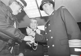
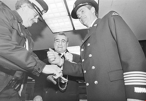
- Caption from metadata for 535-2766-1: "Bill Copeland and former Burnaby fire chief Wayne Brassington are "arrested" at City Hall to raise money for the Cancer Society, in 1996."
- Caption from metadata for 535-2766-2: "Bill Copeland is presented with a "birthday cake" celebrating Burnaby's centennial, in 1992, by Rose Vaughan, 101."
- Caption from metadata for 535-2766-3: "Bill Copeland tries out the computer touch screen at the grand opening of the newly refurbished CW Parker Carousel, at Burnaby Village Museum in April, 1995."
- Caption from metadata for 535-2766-4: "Bill Copeland is presented with Burnaby's new city seal by former premier, Mike Harcourt, part of the city's centennial celebration, in 1992."
- Caption from metadata for 535-2766-6: "Mayor Bill and the late Rudy Spence toast Ellen Betts at a diner honoring her longtime volunteer service with the Burnaby Arts Council, in 1995."
- Caption from metadata for 535-2766-7: "Copeland is congratulated on his re-election as Mayor, in 1993."
- Caption from metadata for 535-2766-8: "Mayor Bill laces up to promote a fitness challenge at Burnaby City Hall, in 1994."
- Caption from metadata for 535-2766-9: "Mayor Bill helps work the phones to promote a Chamber of Commerce membership drive, in 1993."
- Caption from metadata for 535-2766-10: "Mayor Bill helps unveil a plaque honoring doctors Blythe and Violet Eagles, at Deer Lake Park, in 1994."
- Caption from metadata for 535-2766-11: "Mayor Bill opens a new housing co-op on Bellwood Ave., with help from Hedy Fry and former MLA, Barry Gray."
- Caption from metadata for 535-2766-12: "Mayor Bill Copeland briefs the media after the Save-On Foods collapse at Station Square."
- Caption from metadata for 535-2766-13: "Mayor Bill Copeland, Jim Pattison, and other local dignitaries, are all smiles at the official opening of the new Save-On Foods at Station Square. But shortly after the ribbon-cutting ceremony, the new store's roof collapsed."
- Caption from metadata for 535-2766-15: "Mayor Bill tries out a vegetarian plate at the City Hall cafeteria, in 1996."
- Caption from metadata for 535-2766-16: "Bill Copeland celebrates his victory in a water pistol "showdown" against rival mayor, the late Len Trabouley, from Port Coquitlam, in 1992."
- Caption from metadata for 535-2766-17: "Even after he was confined to a wheelchair, following his illness, Bill Copeland continued to attend various city functions."
Images
![Alan Emmott outside the Alan Emmott Centre, [2002] thumbnail](/media/hpo/_Data/_Archives_Images/_Unrestricted/535/535-2835.jpg?width=280)
Alan Emmott outside the Alan Emmott Centre
https://search.heritageburnaby.ca/link/archivedescription97496
- Repository
- City of Burnaby Archives
- Date
- [2002]
- Collection/Fonds
- Burnaby NewsLeader photograph collection
- Description Level
- Item
- Physical Description
- 1 photograph (tiff) : col.
- Scope and Content
- Photograph of Alan Emmott, former reeve and freeman of the City of Burnaby, posing with his arms outstretched outside of the new Alan Emmott Centre community hall, located in the restored former Burnaby South Secondary building, before its official opening.
- Repository
- City of Burnaby Archives
- Date
- [2002]
- Collection/Fonds
- Burnaby NewsLeader photograph collection
- Physical Description
- 1 photograph (tiff) : col.
- Description Level
- Item
- Record No.
- 535-2835
- Access Restriction
- No restrictions
- Reproduction Restriction
- No restrictions
- Accession Number
- 2018-12
- Scope and Content
- Photograph of Alan Emmott, former reeve and freeman of the City of Burnaby, posing with his arms outstretched outside of the new Alan Emmott Centre community hall, located in the restored former Burnaby South Secondary building, before its official opening.
- Subjects
- Officials - Mayors and Reeves
- Buildings - Recreational - Community Halls
- Buildings - Civic - Community Centres
- Names
- Emmott, Alan H.
- Media Type
- Photograph
- Photographer
- Bartel, Mario
- Notes
- Title based on caption
- Collected by editorial for use in a November 2002 issue of the Burnaby NewsLeader
- Caption from metadata: "Alan Emmott, a former mayor of Burnaby and now a Freeman of the City, welcomes visitors to the new community centre that bears his name. The Alan Emmott Centre, in the old Burnaby South Secondary building, officially opens on Saturday."
- Geographic Access
- Southoaks Crescent
- Street Address
- 6650 Southoaks Crescent
- Historic Neighbourhood
- Edmonds (Historic Neighbourhood)
- Planning Study Area
- Kingsway-Beresford Area
Images
![Alan Emmott outside the Alan Emmott Centre, [2002] thumbnail](/media/hpo/_Data/_Archives_Images/_Unrestricted/535/535-2835.jpg)
![Byrne family, [1907] (date of original), copied 1995 thumbnail](/media/hpo/_Data/_Archives_Images/_Unrestricted/316/316-003.jpg?width=280)
Byrne family
https://search.heritageburnaby.ca/link/archivedescription37097
- Repository
- City of Burnaby Archives
- Date
- [1907] (date of original), copied 1995
- Collection/Fonds
- Burnaby Historical Society fonds
- Description Level
- Item
- Physical Description
- 1 photograph : b&w ; 10 x 15 cm print
- Scope and Content
- Photograph of the Byrne family seated and standing in two rows. Margaret is in the middle of the back row, standing between her twin sisters; Mary and Norah. Utan is standing in the front row beside his mother Priscilla who is seated with baby Elizabeth in her hands. Peter is on his wife's other si…
- Repository
- City of Burnaby Archives
- Date
- [1907] (date of original), copied 1995
- Collection/Fonds
- Burnaby Historical Society fonds
- Subseries
- Byrne family subseries
- Physical Description
- 1 photograph : b&w ; 10 x 15 cm print
- Description Level
- Item
- Record No.
- 316-003
- Access Restriction
- No restrictions
- Reproduction Restriction
- No known restrictions
- Accession Number
- BHS1995-04
- Scope and Content
- Photograph of the Byrne family seated and standing in two rows. Margaret is in the middle of the back row, standing between her twin sisters; Mary and Norah. Utan is standing in the front row beside his mother Priscilla who is seated with baby Elizabeth in her hands. Peter is on his wife's other side, with Kathleen beside him. Peter Byrne served as a member of Council from 1894 to 1895 and from 1898 to 1906. He was Reeve of Burnaby from 1906 to 1910.
- Names
- Byrne, Peter
- Byrne, Priscilla Amelia Rowling
- Cyr, Elizabeth Laura Byrne
- Byrne, Margaret "Maggie"
- Byrne, Mary
- Byrne, Norah
- Byrne, Ultan Patrick "Pat"
- Byrne, Kathleen
- Media Type
- Photograph
- Notes
- Title based on contents of photograph
Images
![Byrne family, [1907] (date of original), copied 1995 thumbnail](/media/hpo/_Data/_Archives_Images/_Unrestricted/316/316-003.jpg)
![Charles F. Sprott, [1904 or 1905] (date of original), copied [1995] thumbnail](/media/hpo/_Data/_Archives_Images/_Unrestricted/126/126-003.jpg?width=280)
Charles F. Sprott
https://search.heritageburnaby.ca/link/archivedescription34729
- Repository
- City of Burnaby Archives
- Date
- [1904 or 1905] (date of original), copied [1995]
- Collection/Fonds
- Burnaby Historical Society fonds
- Description Level
- Item
- Physical Description
- 1 photograph : b&w ; 17.0 x 12.0 cm print
- Scope and Content
- Photograph (mounted and titled) of Charles Frederick Sprott, Reeve of Burnaby from 1904 to 1905. He was also a member of Council from 1895 to 1904 and in 1907.
- Repository
- City of Burnaby Archives
- Date
- [1904 or 1905] (date of original), copied [1995]
- Collection/Fonds
- Burnaby Historical Society fonds
- Subseries
- Photographs subseries
- Physical Description
- 1 photograph : b&w ; 17.0 x 12.0 cm print
- Description Level
- Item
- Record No.
- 126-003
- Access Restriction
- No restrictions
- Reproduction Restriction
- No known restrictions
- Accession Number
- BHS2007-04
- Scope and Content
- Photograph (mounted and titled) of Charles Frederick Sprott, Reeve of Burnaby from 1904 to 1905. He was also a member of Council from 1895 to 1904 and in 1907.
- Media Type
- Photograph
Images
![Charles F. Sprott, [1904 or 1905] (date of original), copied [1995] thumbnail](/media/hpo/_Data/_Archives_Images/_Unrestricted/126/126-003.jpg)
![Charles Sprott, [1904] thumbnail](/media/hpo/_Data/_Archives_Images/_Unrestricted/371/459-008.jpg?width=280)
Charles Sprott
https://search.heritageburnaby.ca/link/archivedescription38548
- Repository
- City of Burnaby Archives
- Date
- [1904]
- Collection/Fonds
- Burnaby Historical Society fonds
- Description Level
- Item
- Physical Description
- 1 photograph : b&w ; 7 x 10.8 cm mounted on 10.5 x 13.8 cm page.
- Scope and Content
- Photograph of Charles Frederick Sprott, Burnaby Reeve 1904-1905 and council member from 1895-1904 and again in 1907. A note accompanying the photograph reads: "Charles F. Sprott, Reeve for 1904 and 5. Councillor for nine years previously. Retired undefeated in any election."
- Repository
- City of Burnaby Archives
- Date
- [1904]
- Collection/Fonds
- Burnaby Historical Society fonds
- Subseries
- New Westminster Public Library subseries
- Physical Description
- 1 photograph : b&w ; 7 x 10.8 cm mounted on 10.5 x 13.8 cm page.
- Description Level
- Item
- Record No.
- 459-008
- Access Restriction
- No restrictions
- Reproduction Restriction
- No known restrictions
- Accession Number
- BHS2003-19
- Scope and Content
- Photograph of Charles Frederick Sprott, Burnaby Reeve 1904-1905 and council member from 1895-1904 and again in 1907. A note accompanying the photograph reads: "Charles F. Sprott, Reeve for 1904 and 5. Councillor for nine years previously. Retired undefeated in any election."
- Media Type
- Photograph
- Notes
- Title based on contents of photograph
Images
![Charles Sprott, [1904] thumbnail](/media/hpo/_Data/_Archives_Images/_Unrestricted/371/459-008.jpg)
, copied 1978 thumbnail](/media/hpo/_Data/_BVM_Images/1977/197800010015.jpg?width=280)
Sprott family on the porch
https://search.heritageburnaby.ca/link/museumdescription461
- Repository
- Burnaby Village Museum
- Date
- [190-](date of original), copied 1978
- Collection/Fonds
- Burnaby Village Museum Photograph collection
- Description Level
- Item
- Physical Description
- 1 photograph : b&w ; 20.2 x 25.2 cm print
- Scope and Content
- Photograph of a group of people on the porch of a house. There are six men, three women and three girls standing on the top step of the porch. A catalogue record from 1978 identifies some of the people standing on the porch, however, not very precisely. Standing to the left of the group is Charle…
- Repository
- Burnaby Village Museum
- Collection/Fonds
- Burnaby Village Museum Photograph collection
- Description Level
- Item
- Physical Description
- 1 photograph : b&w ; 20.2 x 25.2 cm print
- Scope and Content
- Photograph of a group of people on the porch of a house. There are six men, three women and three girls standing on the top step of the porch. A catalogue record from 1978 identifies some of the people standing on the porch, however, not very precisely. Standing to the left of the group is Charles Sprott. Beside him are Mr. and Mrs. Edgar Sprott. Depicted to the right of the picture, there are Charles's wife Lucy Schou Sprott, Muriel Sprott, Kitty Hill [?], and Helen Sprott [?]. Charles Sprott was Reeve of Burnaby from 1904 to 1905. He was also a member of Council from 1895 to 1904 and in 1907.
- Names
- Peers, Katherine Maude Hill "Kitty"
- Sprott, Charles Frederick
- Sprott, Louis "Edgar"
- Sprott, Helen Fanny
- Sprott, Helen Louise Faith Nicholls
- Sprott, Muriel
- Sprott, Lucy Christine Schou
- Accession Code
- HV978.1.15
- Access Restriction
- No restrictions
- Reproduction Restriction
- No known restrictions
- Date
- [190-](date of original), copied 1978
- Media Type
- Photograph
- Historic Neighbourhood
- Burnaby Lake (Historic Neighbourhood)
- Scan Resolution
- 600
- Scan Date
- 2023-08-01
- Notes
- Title based on contents of photograph
Images
, copied 1978 thumbnail](/media/hpo/_Data/_BVM_Images/1977/197800010015.jpg)
![Celeste Redman and Gary Begin with Citizens' Plaza paver, [2001] thumbnail](/media/hpo/_Data/_Archives_Images/_Unrestricted/535/535-2245.jpg?width=280)
Celeste Redman and Gary Begin with Citizens' Plaza paver
https://search.heritageburnaby.ca/link/archivedescription96623
- Repository
- City of Burnaby Archives
- Date
- [2001]
- Collection/Fonds
- Burnaby NewsLeader photograph collection
- Description Level
- Item
- Physical Description
- 1 photograph (tiff) : col.
- Scope and Content
- Photograph of City of Burnaby councillors Celeste Redman and Gary Begin outside of City Hall. Begin is holding a prototype of an inscribed paving stone for the Citizens' Plaza at City Hall.
- Repository
- City of Burnaby Archives
- Date
- [2001]
- Collection/Fonds
- Burnaby NewsLeader photograph collection
- Physical Description
- 1 photograph (tiff) : col.
- Description Level
- Item
- Record No.
- 535-2245
- Access Restriction
- No restrictions
- Reproduction Restriction
- No restrictions
- Accession Number
- 2018-12
- Scope and Content
- Photograph of City of Burnaby councillors Celeste Redman and Gary Begin outside of City Hall. Begin is holding a prototype of an inscribed paving stone for the Citizens' Plaza at City Hall.
- Media Type
- Photograph
- Photographer
- Bartel, Mario
- Notes
- Title based on caption
- Collected by editorial for use in an April 2001 issue of the Burnaby NewsLeader
- Caption from metadata: "Burnaby councillors Celeste Redman and Gary Begin examine a prototype for the bricks that will be sold for the Millenium Plaza project behind City Hall."
- Geographic Access
- Canada Way
- Street Address
- 4949 Canada Way
- Historic Neighbourhood
- Burnaby Lake (Historic Neighbourhood)
- Planning Study Area
- Douglas-Gilpin Area
Images
![Celeste Redman and Gary Begin with Citizens' Plaza paver, [2001] thumbnail](/media/hpo/_Data/_Archives_Images/_Unrestricted/535/535-2245.jpg)
![Derek Corrigan at Burnaby Justice Building, [2002] thumbnail](/media/hpo/_Data/_Archives_Images/_Unrestricted/535/535-2925.jpg?width=280)
Derek Corrigan at Burnaby Justice Building
https://search.heritageburnaby.ca/link/archivedescription97626
- Repository
- City of Burnaby Archives
- Date
- [2002]
- Collection/Fonds
- Burnaby NewsLeader photograph collection
- Description Level
- Item
- Physical Description
- 1 photograph (tiff) : col.
- Scope and Content
- Photograph of City of Burnaby councillor Derek Corrigan posing outside of the Burnaby Justice Building next to a sign directing to the Justice Law Courts.
- Repository
- City of Burnaby Archives
- Date
- [2002]
- Collection/Fonds
- Burnaby NewsLeader photograph collection
- Physical Description
- 1 photograph (tiff) : col.
- Description Level
- Item
- Record No.
- 535-2925
- Access Restriction
- No restrictions
- Reproduction Restriction
- No restrictions
- Accession Number
- 2018-12
- Scope and Content
- Photograph of City of Burnaby councillor Derek Corrigan posing outside of the Burnaby Justice Building next to a sign directing to the Justice Law Courts.
- Subjects
- Officials - Aldermen and Councillors
- Officials - Mayors and Reeves
- Buildings - Judicial - Courthouses
- Names
- Corrigan, Derek
- Media Type
- Photograph
- Photographer
- Bartel, Mario
- Notes
- Title based on caption
- Collected by editorial for use in a January 2002 issue of the Burnaby NewsLeader
- Caption from metadata: "Burnaby councillor, and lawyer, Derek Corrigan, is upset over the provincial government's plan to close the city's courthouse. He's leding a debate about the issue at Monday's city council meeting."
- Geographic Access
- Canada Way
- Street Address
- 4946 Canada Way
- Historic Neighbourhood
- Burnaby Lake (Historic Neighbourhood)
- Planning Study Area
- Douglas-Gilpin Area
Images
![Derek Corrigan at Burnaby Justice Building, [2002] thumbnail](/media/hpo/_Data/_Archives_Images/_Unrestricted/535/535-2925.jpg)
![Archivist Arilea Sill with council minutes, [2005] thumbnail](/media/hpo/_Data/_Archives_Images/_Unrestricted/535/535-1951.jpg?width=280)
Archivist Arilea Sill with council minutes
https://search.heritageburnaby.ca/link/archivedescription96268
- Repository
- City of Burnaby Archives
- Date
- [2005]
- Collection/Fonds
- Burnaby NewsLeader photograph collection
- Description Level
- Item
- Physical Description
- 1 photograph (tiff) : col.
- Scope and Content
- Photograph of City of Burnaby archivist Arilea Sill holding up restored pages of City council minutes from 1895-1898. Sill stands in the council chambers of Burnaby's City Hall.
- Repository
- City of Burnaby Archives
- Date
- [2005]
- Collection/Fonds
- Burnaby NewsLeader photograph collection
- Physical Description
- 1 photograph (tiff) : col.
- Description Level
- Item
- Record No.
- 535-1951
- Access Restriction
- No restrictions
- Reproduction Restriction
- No restrictions
- Accession Number
- 2018-12
- Scope and Content
- Photograph of City of Burnaby archivist Arilea Sill holding up restored pages of City council minutes from 1895-1898. Sill stands in the council chambers of Burnaby's City Hall.
- Names
- City of Burnaby Archives
- Media Type
- Photograph
- Photographer
- Medig, Kari
- Notes
- Title based on caption
- Collected by editorial for use in a February 2005 issue of the Burnaby NewsLeader
- Caption from metadata: "Arilea Sill, the City of Burnaby's archivist, displays restored pages of city council minutes from 1895-1898, which were recently found in Victoria. The pages were officially presented to council, to be stored in the city's archives, at Monday's council meeting."
- Geographic Access
- Canada Way
- Street Address
- 4949 Canada Way
- Historic Neighbourhood
- Burnaby Lake (Historic Neighbourhood)
- Planning Study Area
- Douglas-Gilpin Area
Images
![Archivist Arilea Sill with council minutes, [2005] thumbnail](/media/hpo/_Data/_Archives_Images/_Unrestricted/535/535-1951.jpg)
![Millennium Garden at Burnaby City Hall, [2001] thumbnail](/media/hpo/_Data/_Archives_Images/_Unrestricted/535/535-2500.jpg?width=280)
Millennium Garden at Burnaby City Hall
https://search.heritageburnaby.ca/link/archivedescription96945
- Repository
- City of Burnaby Archives
- Date
- [2001]
- Collection/Fonds
- Burnaby NewsLeader photograph collection
- Description Level
- Item
- Physical Description
- 1 photograph (tiff) : col.
- Scope and Content
- Photograph of Ken Smibert, a horticulture subforeman for the City of Burnaby, tending to the new Millennium Garden outside of Burnaby City Hall.
- Repository
- City of Burnaby Archives
- Date
- [2001]
- Collection/Fonds
- Burnaby NewsLeader photograph collection
- Physical Description
- 1 photograph (tiff) : col.
- Description Level
- Item
- Record No.
- 535-2500
- Access Restriction
- No restrictions
- Reproduction Restriction
- No restrictions
- Accession Number
- 2018-12
- Scope and Content
- Photograph of Ken Smibert, a horticulture subforeman for the City of Burnaby, tending to the new Millennium Garden outside of Burnaby City Hall.
- Names
- Burnaby City Hall
- Media Type
- Photograph
- Photographer
- Bartel, Mario
- Notes
- Title based on caption
- Collected by editorial for use in a June 2001 issue of the Burnaby NewsLeader
- Caption from metadata: "Ken Smibert, a horticulture subforeman for the City of Burnaby, is in charge of keeping the new Millenium Garden, at City Hall, looking its best. The garden officially opened on Saturday."
- Geographic Access
- Canada Way
- Street Address
- 4949 Canada Way
- Historic Neighbourhood
- Burnaby Lake (Historic Neighbourhood)
- Planning Study Area
- Douglas-Gilpin Area
Images
![Millennium Garden at Burnaby City Hall, [2001] thumbnail](/media/hpo/_Data/_Archives_Images/_Unrestricted/535/535-2500.jpg)
![Alan Emmott in community centre, [2003] thumbnail](/media/hpo/_Data/_Archives_Images/_Unrestricted/535/535-1804.jpg?width=280)
Alan Emmott in community centre
https://search.heritageburnaby.ca/link/archivedescription96055
- Repository
- City of Burnaby Archives
- Date
- [2003]
- Collection/Fonds
- Burnaby NewsLeader photograph collection
- Description Level
- Item
- Physical Description
- 1 photograph (tiff) : col.
- Scope and Content
- Photograph of Alan Emmott holding a keyboard in a classroom at the Alan Emmott Community Centre.
- Repository
- City of Burnaby Archives
- Date
- [2003]
- Collection/Fonds
- Burnaby NewsLeader photograph collection
- Physical Description
- 1 photograph (tiff) : col.
- Description Level
- Item
- Record No.
- 535-1804
- Access Restriction
- No restrictions
- Reproduction Restriction
- No restrictions
- Accession Number
- 2018-12
- Scope and Content
- Photograph of Alan Emmott holding a keyboard in a classroom at the Alan Emmott Community Centre.
- Media Type
- Photograph
- Photographer
- Bartel, Mario
- Notes
- Title based on caption
- Collected by editorial for use in a January 2003 issue of the Burnaby NewsLeader
- Caption from metadata: "Alan Emmett is amongst the first students getting ready for classes at the Community Centre that bears his name, and is now the new home for the Community College of the Retired. He's taking a computer course."
- Geographic Access
- Southoaks Crescent
- Street Address
- 6650 Southoaks Crescent
- Historic Neighbourhood
- Edmonds (Historic Neighbourhood)
- Planning Study Area
- Kingsway-Beresford Area
Images
![Alan Emmott in community centre, [2003] thumbnail](/media/hpo/_Data/_Archives_Images/_Unrestricted/535/535-1804.jpg)
![Elizabeth Nelson at Citizens' Plaza opening, [2002] thumbnail](/media/hpo/_Data/_Archives_Images/_Unrestricted/535/535-2785.jpg?width=280)
Elizabeth Nelson at Citizens' Plaza opening
https://search.heritageburnaby.ca/link/archivedescription97423
- Repository
- City of Burnaby Archives
- Date
- [2002]
- Collection/Fonds
- Burnaby NewsLeader photograph collection
- Description Level
- Item
- Physical Description
- 1 photograph (tiff) : col.
- Scope and Content
- Photograph of Elizabeth Nelson crouching down to photograph an engraved paving stone at the opening of the Citizens' Plaza at Burnaby City Hall.
- Repository
- City of Burnaby Archives
- Date
- [2002]
- Collection/Fonds
- Burnaby NewsLeader photograph collection
- Physical Description
- 1 photograph (tiff) : col.
- Description Level
- Item
- Record No.
- 535-2785
- Access Restriction
- No restrictions
- Reproduction Restriction
- No restrictions
- Accession Number
- 2018-12
- Scope and Content
- Photograph of Elizabeth Nelson crouching down to photograph an engraved paving stone at the opening of the Citizens' Plaza at Burnaby City Hall.
- Names
- Burnaby City Hall
- Media Type
- Photograph
- Photographer
- Bartel, Mario
- Notes
- Title based on caption
- Collected by editorial for use in a September 2002 issue of the Burnaby NewsLeader
- Caption from metadata: "Elizabeth Nelson stoops to photograph her sister's commemorative paving stone at the official opening of the new Citizen's Plaza at Burnaby City Hall. For $100, donors could engrave a message on one of the paver stones in the plaza, with half the proceeds going to the charity of their choice."
- Geographic Access
- Canada Way
- Street Address
- 4949 Canada Way
- Historic Neighbourhood
- Burnaby Lake (Historic Neighbourhood)
- Planning Study Area
- Douglas-Gilpin Area
Images
![Elizabeth Nelson at Citizens' Plaza opening, [2002] thumbnail](/media/hpo/_Data/_Archives_Images/_Unrestricted/535/535-2785.jpg)