More like 'Heritage Village'
Narrow Results By
Decade
- 2020s 88
- 2010s 44
- 2000s 547
- 1990s 411
- 1980s 412
- 1970s
- 1960s 312
- 1950s 497
- 1940s 463
- 1930s 382
- 1920s 413
- 1910s 496
- 1900s
- 1890s 32
- 1880s 52
- 1870s 5
- 1860s 3
- 1850s 2
- 1840s 1
- 1830s 1
- 1820s 1
- 1810s 2
- 1800s 2
- 1790s 2
- 1780s 2
- 1770s 2
- 1760s 2
- 1750s 2
- 1740s 2
- 1730s 2
- 1720s 2
- 1710s 2
- 1700s 2
- 1690s 2
- 1680s 2
- 1670s 2
- 1660s 2
- 1650s 2
- 1640s 2
- 1630s 2
- 1620s 2
- 1610s 2
- 1600s 2
- 1590s 1
- 1580s 1
- 1570s 1
- 1560s 1
- 1550s 1
- 1540s 1
- 1530s 1
- 1520s 1
- 1510s 1
- 1500s 1
- 1490s 1
- 1480s 1
Subject
- Advertising Medium - Signs and Signboards 32
- Aerial Photographs 8
- Agricultural Tools and Equipment 10
- Agriculture - Beekeeping 3
- Agriculture - Crops 7
- Agriculture - Farms 15
- Agriculture - Fruit and Berries 7
- Agriculture - Poultry 1
- Animals - Birds 1
- Animals - Cats 3
- Animals - Cows 2
- Animals - Dogs 8

Duncan & Margaret McGregor Estate 'Glen-Lyon' Mansion
https://search.heritageburnaby.ca/link/landmark518
- Repository
- Burnaby Heritage Planning
- Description
- Overlooking the rich farmland of the Fraser River floodplain, 'Glen-Lyon' is an Edwardian era rural estate, with a tall, two and one-half storey plus basement wood-frame mansion, set in a pastoral and formal landscape with an associated barn and early log pond, located near a ravine and forested ar…
- Associated Dates
- 1902
- Formal Recognition
- Heritage Designation, Community Heritage Register
- Street View URL
- Google Maps Street View
- Repository
- Burnaby Heritage Planning
- Geographic Access
- Marine Drive
- Associated Dates
- 1902
- Formal Recognition
- Heritage Designation, Community Heritage Register
- Enactment Type
- Bylaw No. 12183
- Enactment Date
- 11/12/2006
- Description
- Overlooking the rich farmland of the Fraser River floodplain, 'Glen-Lyon' is an Edwardian era rural estate, with a tall, two and one-half storey plus basement wood-frame mansion, set in a pastoral and formal landscape with an associated barn and early log pond, located near a ravine and forested area adjacent to Marine Drive in South Burnaby.
- Heritage Value
- ‘Glen-Lyon’ is valued as an excellent example of a privately-owned Edwardian era country estate built at the turn of the nineteenth century. The property retains significant heritage features including the Edwardian era mansion with rustic Arts and Crafts features, and elements of a working agricultural landscape. The property was originally the Royal City Mills logging camp, and in 1900 was purchased by Duncan Campbell McGregor (1853-1929) and Margaret Jane McGregor (1875-1960), who named their estate ‘Glen-Lyon’ after Duncan McGregor’s birthplace in Perthshire, Scotland. The McGregors were active in municipal affairs and social activities, and played a significant role in the early development of Burnaby. Duncan McGregor served as a city councillor from 1909 to 1912 and was elected reeve of Burnaby in 1913. Margaret McGregor was instrumental in the formation and fundraising activities of the Victoria Order of Nurses in Burnaby. Additionally, the site is historically significant for its association with early social welfare and correctional reform. The estate was sold in 1926 to an inter-denominational religious organization called the Home of the Friendless, which used it as their B.C. headquarters. The organization was charged with several cases of abuse and neglect in 1937, after which a Royal Commission was formed that led to new legislation to regulate and license all private welfare institutions. 'Glen-Lyon' was sold to the provincial government, and was dedicated in 1939 by the Lt.-Gov. E.W. Hamber for use as the New Haven Borstal Home for Boys and Youthful Offenders (later renamed the New Haven Correction Centre). The Borstal movement originated in England in the late nineteenth century, as an alternative to sending young offenders and runaways to prisons by providing reformatories that focused on discipline and vocational skill. This site’s role as the first North American institution devoted to the Borstal School philosophy was historic, and influenced corrections programs across Canada. The site retains significant features from its development in 1939 as the Borstal School, including a large gambrel-roofed barn designed by Chief Provincial Architect Henry Whittaker of the Department of Public Works that is the only remaining structure of its kind in Burnaby. Between 1941 and 1945 the mansion housed the Provincial School for the Deaf and Blind when the Borstal School was closed temporarily as a war measure during the Second World War.
- Defining Elements
- Key elements that define the heritage character of 'Glen-Lyon' Mansion include its: - location on a sloping site with expansive southern exposure, adjacent to Marine Drive - residential form, scale and massing of the house as exemplified by its two and one-half storey height, above-ground basement and rectangular plan - Arts and Crafts elements of the house such as its stone foundation, multi-gabled roof line with steep central hipped roof, symmetrical cross-gables, side shed dormers, bellcast upper walls sheathed in cedar shingles and lower walls sheathed in narrow clapboard - original exterior features of the house such as the full width front verandah with square columns, central staircase on the southern elevation, original doors and stained glass windows; and the irregular fenestration such as double-hung 1-over-1 wooden-sash windows, bay windows, and projecting windows in the gable ends - original interior features of the house such as the U-shaped main stair designed around two symmetrically placed Ionic columns, and interior trim on the main floor including boxed beams and fireplaces - gambrel-roofed barn with roof vent with finial, sliding hay loft and access doors, small multi-pane windows, and lapped wooden siding - associated landscape features such as the original garden plantings with some exotic and many native specimen trees; the original log pond and its concrete Marine Drive causeway and culvert; rockeries and a rose garden
- Historic Neighbourhood
- Fraser Arm (Historic Neighbourhood)
- Planning Study Area
- Big Bend Area
- Architect
- Henry Whittaker
- Function
- Primary Historic--Estate
- Community
- Burnaby
- Cadastral Identifier
- 003-004-661
- Boundaries
- 'Glen-Lyon' is comprised of a single residential lot located at 4250 Marine Drive, Burnaby.
- Area
- 230873.18
- Contributing Resource
- Building
- Ownership
- Private
- Names
- McGregor, Duncan C. (1853-1929)
- Whittaker, Henry
- Home of the Friendless
- Borstal School
- New Haven Correction Centre
- Subjects
- Buildings - Heritage
- Buildings - Residential - Houses
- Buildings - Public - Detention Facilities
- Buildings - Residential
- Street Address
- 4250 Marine Drive
- Street View URL
- Google Maps Street View
Images


H.T. Ceperley Estate 'Fairacres' Steam Plant Building
https://search.heritageburnaby.ca/link/landmark528
- Repository
- Burnaby Heritage Planning
- Description
- Designed in the British Arts and Crafts style, the ‘Fairacres’ Steam Plant Buiding is a single-storey wood frame building with a gabled roof that originally housed the apparatus for climate control in the greenhouses, formerly located to its north. The original rubble stone walls that formed the fo…
- Associated Dates
- 1908
- Formal Recognition
- Heritage Designation, Community Heritage Register
- Repository
- Burnaby Heritage Planning
- Geographic Access
- Deer Lake Avenue
- Associated Dates
- 1908
- Formal Recognition
- Heritage Designation, Community Heritage Register
- Enactment Type
- Bylaw No. 9807
- Enactment Date
- 23/11/1992
- Description
- Designed in the British Arts and Crafts style, the ‘Fairacres’ Steam Plant Buiding is a single-storey wood frame building with a gabled roof that originally housed the apparatus for climate control in the greenhouses, formerly located to its north. The original rubble stone walls that formed the foundation for the greenhouses stand adjacent. The Steam Plant Building stands as a pendant to the Root House, which is to the north of the former greenhouses.
- Heritage Value
- The outbuildings at 'Fairacres' are a rare surviving architecturally-designed ensemble of agricultural structures that exist in complementary harmony with the main estate house. Architect Robert Mackay Fripp (1858-1917), an outspoken advocate of Arts and Crafts design, was retained by the Ceperleys to design several original outbuildings on their estate. The Ceperleys operated 'Fairacres' with staff, a farm manager and workers, including Chinese, to grow produce for themselves and for sale at local markets. The Steam Plant Building illustrates the market gardening activity of the area around Deer Lake and its importance to the Ceperley family, which valued a year-round supply of fresh fruit and vegetables for the kitchen and flowers for the house. It also illustrates the cultural and aesthetic values of the Ceperleys in retaining an architect to design a functional outbuilding using an accepted and contemporary architectural style. Built in 1908, the Steam Plant Building was significantly altered in the 1960s and restored to its original design in 2000.
- Defining Elements
- Key elements that define the heritage character of the ‘Fairacres’ Steam Plant Building include its: - overall spatial arrangement of the Steam Plant Building in relation to the former greenhouses and the Root House - side gable roof with cedar shingle cladding. - tall brick chimney indicitive of the building's original function. - distinctive Arts and Crafts architectural features such as the shingle wall cladding with decorative shingling under window sills, deep eaves, and pebble-dashed concrete foundation walls - six-paned wooden-sash casement windows - simple functional interior features - rubble stone walls that formed the foundation for the greenhouses
- Locality
- Deer Lake Park
- Historic Neighbourhood
- Burnaby Lake (Historic Neighbourhood)
- Planning Study Area
- Douglas-Gilpin Area
- Architect
- Robert Mackay Fripp
- Function
- Primary Historic--Outbuilding
- Community
- Burnaby
- Cadastral Identifier
- P.I.D. No. 004-493-311 Legal Description: Block 3 Except: Part subdivided by Plan 26865, District Lot 79, Group 1, New Westminster District, Plan 536
- Boundaries
- ‘Fairacres’ is comprised of a single municipally-owned property located at 6344 Deer Lake Avenue, Burnaby.
- Area
- 17,065.00
- Contributing Resource
- Building
- Landscape Feature
- Ownership
- Public (local)
- Other Collection
- Burnaby Historical Society, Community Archives: Ceperley Photograph Album
- Documentation
- Heritage Site Files: PC77000 20. City of Burnaby Planning and Building Department, 4949 Canada Way, Burnaby, B.C., V5G 1M2
- Street Address
- 6344 Deer Lake Avenue
Images


H.T. Ceperley Estate 'Fairacres' Greenhouse Foundation Wall
https://search.heritageburnaby.ca/link/landmark862
- Repository
- Burnaby Heritage Planning
- Description
- The original rubble stone walls that formed the foundation for a greenhouses adjacent to the Steam Plant Building provided heat to several greenhouses on the estate propoerty. The Root House, which is to the north of the Greenhouse Foundation Wall, provided storage for the farm operation.
- Associated Dates
- 1908
- Formal Recognition
- Heritage Designation, Community Heritage Register
- Repository
- Burnaby Heritage Planning
- Geographic Access
- Deer Lake Avenue
- Associated Dates
- 1908
- Formal Recognition
- Heritage Designation, Community Heritage Register
- Enactment Type
- Bylaw No. 140665
- Enactment Date
- 23/11/1992
- Description
- The original rubble stone walls that formed the foundation for a greenhouses adjacent to the Steam Plant Building provided heat to several greenhouses on the estate propoerty. The Root House, which is to the north of the Greenhouse Foundation Wall, provided storage for the farm operation.
- Heritage Value
- The outbuildings at 'Fairacres' are a rare surviving architecturally-designed ensemble of agricultural structures that exist in complementary harmony with the main estate house. Architect Robert Mackay Fripp (1858-1917), an outspoken advocate of Arts and Crafts design, was retained by the Ceperleys to design several original outbuildings on their estate, which was designed as a country estate with a working farm that included over 10 acres of productive berry and vegetable fields, with a large kitchen garden, a root house to store food, an orchard, and greenhouses heated by steam. The agricultural potential of the Deer Lake area made it one of the first parts of the municipality to attract settlement. In 1909, the Ceperleys built three large greenhouses heated by an adjacent steam plant (Fairacres Steam Plant). The greenhouses featured granite foundation walls, including this one which remains intact. The Ceperleys employed a large staff to manage the estate's agricultural production, including Chinese farm labourers. Produce was grown for use at the estate, and for sale at local markets. Agricultural use of the estate continued when a Catholic order of Benedictine monks purchased the estate as part of the Priory of St. Joseph and the Seminary of Christ the King, and continued to farm the land until 1953.
- Defining Elements
- Key elements that define the heritage character of the ‘Fairacres’ Steam Plant Building include its: - overall spatial arrangement of the Greenhouse Foundation Wall in relation to the Steam Plant Building and the Root House - original rubble stone walls reflecting the Arts and Crafts design aesthetic of the estate buildings.
- Locality
- Deer Lake Park
- Historic Neighbourhood
- Burnaby Lake (Historic Neighbourhood)
- Planning Study Area
- Douglas-Gilpin Area
- Architect
- Robert Mackay Fripp
- Function
- Primary Historic--Outbuilding
- Community
- Burnaby
- Cadastral Identifier
- P.I.D. No. 004-493-311 Legal Description: Block 3 Except: Part subdivided by Plan 26865, District Lot 79, Group 1, New Westminster District, Plan 536
- Boundaries
- ‘Fairacres’ is comprised of a single municipally-owned property located at 6344 Deer Lake Avenue, Burnaby.
- Area
- 17,065.00
- Contributing Resource
- Landscape Feature
- Remains
- Ownership
- Public (local)
- Other Collection
- Burnaby Historical Society, Community Archives: Ceperley Photograph Album
- Documentation
- Heritage Site Files: PC77000 20. City of Burnaby Planning and Building Department, 4949 Canada Way, Burnaby, B.C., V5G 1M2
- Street Address
- 6344 Deer Lake Avenue
Images


H.T. Ceperley Estate 'Fairacres' Root House
https://search.heritageburnaby.ca/link/landmark527
- Repository
- Burnaby Heritage Planning
- Description
- The ‘Fairacres’ Root House is a long, low one-storey masonry building, measuring 4.6 metres by 9.1 metres, with massively buttressed concrete walls and foundations. Built into sloping ground adjacent to the location of the former greenhouses, the surviving orchard and the kitchen entrance of the ma…
- Associated Dates
- 1908
- Formal Recognition
- Heritage Designation, Community Heritage Register
- Repository
- Burnaby Heritage Planning
- Geographic Access
- Deer Lake Avenue
- Associated Dates
- 1908
- Formal Recognition
- Heritage Designation, Community Heritage Register
- Enactment Type
- Bylaw No. 9807
- Enactment Date
- 23/11/1992
- Description
- The ‘Fairacres’ Root House is a long, low one-storey masonry building, measuring 4.6 metres by 9.1 metres, with massively buttressed concrete walls and foundations. Built into sloping ground adjacent to the location of the former greenhouses, the surviving orchard and the kitchen entrance of the main house, 'Fairacres,' this functional structure was used as a frost-free store for fruit and vegetables for the family's use.
- Heritage Value
- The outbuildings at 'Fairacres' are a rare surviving architecturally-designed ensemble of agricultural structures that exist in complementary harmony with the main estate house. Architect Robert Mackay Fripp (1858-1917), an outspoken advocate of Arts and Crafts design, was retained by the Ceperleys to design several original outbuildings on their estate. The Root House is important as a rare surviving, and exceptionally large, example of this building type in the Vancouver region. Unusual in the fact that an architect designed a building of such modest aspirations, it is also remarkable in its method of construction. The use of concrete as a structural material is one of the earliest in the region and extraordinary for its use on such a modest vernacular outbuilding; root cellars were typically built of loose stone. Built in 1908, the Root House was significantly altered in the 1960s and restored to its original design in 2000. The building is significant as an indicator of the market gardening activity in the area around Deer Lake and of the country-house self-sufficiency practiced by the Ceperley family. The Root House illustrates the cultural, aesthetic, and lifestyle values of the Ceperleys in constructing such a large building for storing their own produce.
- Defining Elements
- The outbuildings at 'Fairacres' are a rare surviving architecturally-designed ensemble of agricultural structures that exist in complementary harmony with the main estate house. Architect Robert Mackay Fripp (1858-1917), an outspoken advocate of Arts and Crafts design, was retained by the Ceperleys to design several original outbuildings on their estate. The Root House is important as a rare surviving, and exceptionally large, example of this building type in the Vancouver region. Unusual in the fact that an architect designed a building of such modest aspirations, it is also remarkable in its method of construction. The use of concrete as a structural material is one of the earliest in the region and extraordinary for its use on such a modest vernacular outbuilding; root cellars were typically built of loose stone. Built in 1908, the Root House was significantly altered in the 1960s and restored to its original design in 2000. The building is significant as an indicator of the market gardening activity in the area around Deer Lake and of the country-house self-sufficiency practiced by the Ceperley family. The Root House illustrates the cultural, aesthetic, and lifestyle values of the Ceperleys in constructing such a large building for storing their own produce.
- Locality
- Deer Lake Park
- Historic Neighbourhood
- Burnaby Lake (Historic Neighbourhood)
- Planning Study Area
- Douglas-Gilpin Area
- Architect
- Robert Mackay Fripp
- Function
- Primary Historic--Outbuilding
- Secondary Historic--Food Storage
- Community
- Burnaby
- Cadastral Identifier
- P.I.D. No. 004-493-311 Legal Description: Block 3 Except: Part subdivided by Plan 26865, District Lot 79, Group 1, New Westminster District, Plan 536
- Boundaries
- ‘Fairacres’ is comprised of a single municipally-owned property located at 6344 Deer Lake Avenue, Burnaby.
- Area
- 17,065.00
- Contributing Resource
- Building
- Landscape Feature
- Ownership
- Public (local)
- Other Collection
- Burnaby Historical Society, Community Archives: Ceperley Photograph Album
- Documentation
- Heritage Site Files: PC77000 20. City of Burnaby Planning and Building Department, 4949 Canada Way, Burnaby, B.C., V5G 1M2
- Street Address
- 6344 Deer Lake Avenue
Images

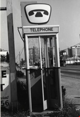
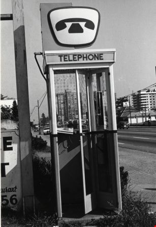
Telephone Booth
https://search.heritageburnaby.ca/link/archivedescription79932
- Repository
- City of Burnaby Archives
- Date
- September 24, 1976
- Collection/Fonds
- Burnaby Public Library Contemporary Visual Archive Project
- Description Level
- Item
- Physical Description
- 1 photograph : b&w ; 11 x 16 cm mounted on cardboard
- Scope and Content
- Photograph shows telephone booth at Kingsway and Griffiths Avenue.
- Repository
- City of Burnaby Archives
- Date
- September 24, 1976
- Collection/Fonds
- Burnaby Public Library Contemporary Visual Archive Project
- Physical Description
- 1 photograph : b&w ; 11 x 16 cm mounted on cardboard
- Description Level
- Item
- Record No.
- 556-503
- Access Restriction
- No restrictions
- Reproduction Restriction
- Reproduce for fair dealing purposes only
- Accession Number
- 2013-13
- Scope and Content
- Photograph shows telephone booth at Kingsway and Griffiths Avenue.
- Media Type
- Photograph
- Photographer
- Born, A. J.
- Notes
- Scope note taken directly from BPL photograph description.
- 1 b&w copy negative : 10 x 12.5 cm accompanying
- Geographic Access
- Kingsway
- Griffiths Avenue
- Planning Study Area
- Richmond Park Area
Images
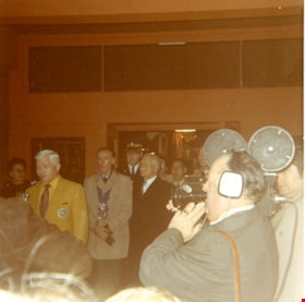
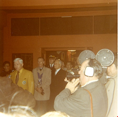
Governor General Roland Michener and officials at Heritage Village opening
https://search.heritageburnaby.ca/link/museumdescription13569
- Repository
- Burnaby Village Museum
- Date
- 19 November 1971
- Collection/Fonds
- Donald Copan collection
- Description Level
- Item
- Physical Description
- 1 photograph : col. ; 8.9 x 8.9 cm
- Scope and Content
- Photograph of officials at the opening ceremony for Heritage Village Museum (Burnaby Village Museum). Burnaby Centennial '71 Committee member Sandy Stewart (in yellow jacket) is standing next to Mayor Bob Prittie and Governor General Roland Michener (centre, in black suit). A man is holding a telev…
- Repository
- Burnaby Village Museum
- Collection/Fonds
- Donald Copan collection
- Series
- Copan album series
- Description Level
- Item
- Physical Description
- 1 photograph : col. ; 8.9 x 8.9 cm
- Scope and Content
- Photograph of officials at the opening ceremony for Heritage Village Museum (Burnaby Village Museum). Burnaby Centennial '71 Committee member Sandy Stewart (in yellow jacket) is standing next to Mayor Bob Prittie and Governor General Roland Michener (centre, in black suit). A man is holding a television camera on his shoulder and filming the event.
- Subjects
- Events - Openings
- Telecommunication Tools and Equipment - Televisions
- Photographic Tools and Equipment
- Names
- Prittie, Robert W. "Bob"
- Michener, Daniel Roland "Roland"
- Stewart, A.B. "Sandy"
- Burnaby Village Museum
- Accession Code
- BV005.54.461
- Access Restriction
- No restrictions
- Reproduction Restriction
- May be restricted by third party rights
- Date
- 19 November 1971
- Media Type
- Photograph
- Scan Resolution
- 600
- Scan Date
- August 11, 2020
- Scale
- 100
- Notes
- Title based on contents of photograph
Images
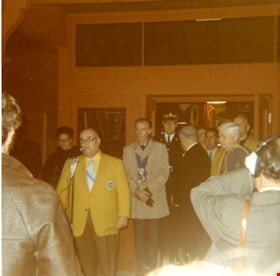
Governor General Roland Michener and officials at Heritage Village opening
https://search.heritageburnaby.ca/link/museumdescription13570
- Repository
- Burnaby Village Museum
- Date
- 19 November 1971
- Collection/Fonds
- Donald Copan collection
- Description Level
- Item
- Physical Description
- 1 photograph : col. ; 8.9 x 8.9 cm
- Scope and Content
- Photograph of officials at the opening ceremony for Heritage Village Museum (Burnaby Village Museum). Burnaby Centennial '71 Committee chair James Barrington is speaking from a microphone. Mayor Bob Prittie and Governor General Roland Michener are standing to the right. A man is holding a televisio…
- Repository
- Burnaby Village Museum
- Collection/Fonds
- Donald Copan collection
- Series
- Copan album series
- Description Level
- Item
- Physical Description
- 1 photograph : col. ; 8.9 x 8.9 cm
- Scope and Content
- Photograph of officials at the opening ceremony for Heritage Village Museum (Burnaby Village Museum). Burnaby Centennial '71 Committee chair James Barrington is speaking from a microphone. Mayor Bob Prittie and Governor General Roland Michener are standing to the right. A man is holding a television camera on his shoulder and filming the event.
- Subjects
- Events - Openings
- Telecommunication Tools and Equipment - Televisions
- Photographic Tools and Equipment
- Names
- Prittie, Robert W. "Bob"
- Michener, Daniel Roland "Roland"
- Barrington, James Alfred "Jim"
- Burnaby Village Museum
- Accession Code
- BV005.54.462
- Access Restriction
- No restrictions
- Reproduction Restriction
- May be restricted by third party rights
- Date
- 19 November 1971
- Media Type
- Photograph
- Scan Resolution
- 600
- Scan Date
- August 11, 2020
- Scale
- 100
- Notes
- Title based on contents of photograph
Images

Interview with Allan Nixon by Rod Fowler February 21, 1990 - Track 7
https://search.heritageburnaby.ca/link/oralhistory470
- Repository
- City of Burnaby Archives
- Date Range
- 1936-1990
- Length
- 00:04:34
- Summary
- This portion of the interview is about Al Nixon describing the importance of good record keeping, using an example of an 1936 fire record used in a civic law suit. He expressed concerned about the lack of museum and archives facilities in Burnaby.
- Repository
- City of Burnaby Archives
- Summary
- This portion of the interview is about Al Nixon describing the importance of good record keeping, using an example of an 1936 fire record used in a civic law suit. He expressed concerned about the lack of museum and archives facilities in Burnaby.
- Date Range
- 1936-1990
- Length
- 00:04:34
- Interviewer
- Fowler, Rod
- Interview Date
- February 21, 1990
- Scope and Content
- Recording is of an interview with Al Nixon, conducted by Rod Fowler. Al Nixon was one of eleven participants interviewed as part of the SFU/Burnaby Centennial Committee's oral history series titled, "Voices of Burnaby". The interview is mainly about the history and operations of the Burnaby Fire Department from its beginning in 1911 to 1990, and Al Nixon’s stories about the various ways photographs, records and artifacts about the department were collected and saved. The interview takes place while looking at photographs, but the information is clear nonetheless (His photographs have been deposited in the Burnaby Archives). Al Nixon also talks about his father's career as a firefighter, and about his Douglas grandparents and their home “The Gables” [Seven Gables] and neighbourhood in Burquitlam. To view “Narrow By” terms for each track expand this description and see “Notes”.
- Biographical Notes
- Al Nixon was born in New Westminster Feb. 8, 1936, the son of Provincial Fire Marshal Basil Nixon (1904-1975) and Agnes Douglas (1909-?). His mother’s family immigrated to Canada from Scotland in 1922 and lived in a large ca. 1900 home in Burquitlam at 9957 Sullivan Road called “Seven Gables” (recently demolished). His grandfather Thomas Douglas, a Coquitlam Councillor and Socialist, was murdered in 1934 in his North Road service station. Al Nixon began his career as a firefighter with the Burnaby Fire Department in 1957, eventually becoming Deputy Fire Chief Operations in 1987 and Fire Chief in 1991, before retiring in 1993. In the mid 1980's Al Nixon became interested in the department’s history after finding a photograph scrapbook at one of the firehalls. It was in very bad condition but he recognized its value and began a project to collect and save photographs, artifacts and stories about the Burnaby Fire Department, a 6 month project that turned into years. The photographs and information gathered by Al Nixon became part of Douglas Penn’s book “Follow that Fire: the history of the Burnaby Fire Department”.
- Total Tracks
- 8
- Total Length
- 0:43:35
- Interviewee Name
- Nixon, Al
- Interviewer Bio
- Rod Fowler returned to university as a mature student in the 1980s after working about twenty years in the field of economics and computerization in business in England, Europe and Western Canada. He graduated with a BA from SFU in both History and Sociology in 1987, his MA degree in Geography in 1989, and his PhD in Cultural Geography at SFU. He taught courses in Geography, Sociology, History and Canadian Studies at several Lower Mainland colleges, before becoming a full time member of the Geography Department at Kwantlen University College.
- Collection/Fonds
- SFU/Burnaby Centennial Committee fonds
- Transcript Available
- Transcript available
- Media Type
- Sound Recording
- Web Notes
- Interviews were digitized in 2015 allowing them to be accessible on Heritage Burnaby. The digitization project was initiated by the Community Heritage Commission with support from City of Burnaby Council.
Audio Tracks
Track seven of interview with Al Nixon
Track seven of interview with Al Nixon
https://search.heritageburnaby.ca/media/hpo/_Data/_Archives_Oral_Histories/_Unrestricted/MSS187-014/MSS187-014_Track_7.mp3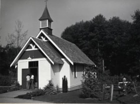
Heritage Village
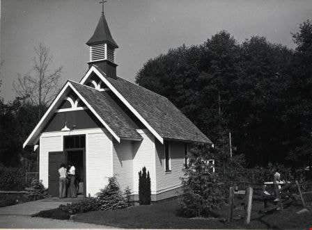
https://search.heritageburnaby.ca/link/archivedescription79787
- Repository
- City of Burnaby Archives
- Date
- September, 1976
- Collection/Fonds
- Burnaby Public Library Contemporary Visual Archive Project
- Description Level
- Item
- Physical Description
- 1 photograph : b&w ; 11 x 16 cm mounted on cardboard
- Scope and Content
- Photograph shows the church at Heritage Village which is used for private ceremonies such as weddings and baptisms.
- Repository
- City of Burnaby Archives
- Date
- September, 1976
- Collection/Fonds
- Burnaby Public Library Contemporary Visual Archive Project
- Physical Description
- 1 photograph : b&w ; 11 x 16 cm mounted on cardboard
- Description Level
- Item
- Record No.
- 556-434
- Access Restriction
- No restrictions
- Reproduction Restriction
- Reproduce for fair dealing purposes only
- Accession Number
- 2013-13
- Scope and Content
- Photograph shows the church at Heritage Village which is used for private ceremonies such as weddings and baptisms.
- Names
- Burnaby Village Museum
- Media Type
- Photograph
- Photographer
- Salmon, Stu
- Notes
- Scope note taken directly from BPL photograph description.
- 1 b&w copy negative : 10 x 12.5 cm accompanying
- Geographic Access
- Deer Lake Avenue
- Street Address
- 6501 Deer Lake Avenue
- Historic Neighbourhood
- Burnaby Lake (Historic Neighbourhood)
- Planning Study Area
- Morley-Buckingham Area
Images
Heritage Village
https://search.heritageburnaby.ca/link/archivedescription79789
- Repository
- City of Burnaby Archives
- Date
- July 17, 1976
- Collection/Fonds
- Burnaby Public Library Contemporary Visual Archive Project
- Description Level
- Item
- Physical Description
- 1 photograph : b&w ; 11 x 16 cm mounted on cardboard
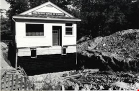
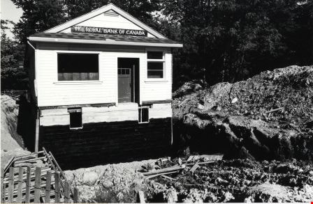
- Scope and Content
- Photograph shows the Royal Bank of Canada building under construction in Heritage Village.
- Repository
- City of Burnaby Archives
- Date
- July 17, 1976
- Collection/Fonds
- Burnaby Public Library Contemporary Visual Archive Project
- Physical Description
- 1 photograph : b&w ; 11 x 16 cm mounted on cardboard
- Description Level
- Item
- Record No.
- 556-435
- Access Restriction
- No restrictions
- Reproduction Restriction
- Reproduce for fair dealing purposes only
- Accession Number
- 2013-13
- Scope and Content
- Photograph shows the Royal Bank of Canada building under construction in Heritage Village.
- Names
- Burnaby Village Museum
- Media Type
- Photograph
- Photographer
- Gardiner, Robert
- Notes
- Scope note taken directly from BPL photograph description.
- 1 b&w copy negative : 10 x 12.5 cm accompanying
- Geographic Access
- Deer Lake Avenue
- Street Address
- 6501 Deer Lake Avenue
- Historic Neighbourhood
- Burnaby Lake (Historic Neighbourhood)
- Planning Study Area
- Morley-Buckingham Area
Images
Anik-B educational television system
https://search.heritageburnaby.ca/link/archivedescription45456
- Repository
- City of Burnaby Archives
- Date
- 1979
- Collection/Fonds
- Columbian Newspaper collection
- Description Level
- Item
- Physical Description
- 1 photograph : b&w ; 19 x 22.5 cm
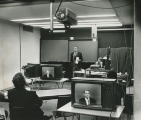
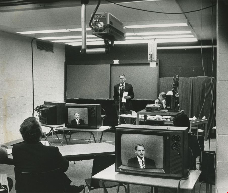
- Scope and Content
- Photograph of Education Minister Pat McGreer delivering the first message with the Anik-B educational television system which connected fourteen classrooms around the province and in the Northwest Territories to the originating studio at the British Columbia Institute of Technology.
- Repository
- City of Burnaby Archives
- Date
- 1979
- Collection/Fonds
- Columbian Newspaper collection
- Physical Description
- 1 photograph : b&w ; 19 x 22.5 cm
- Description Level
- Item
- Record No.
- 480-351
- Access Restriction
- No restrictions
- Reproduction Restriction
- Reproduce for fair dealing purposes only
- Accession Number
- 2003-02
- Scope and Content
- Photograph of Education Minister Pat McGreer delivering the first message with the Anik-B educational television system which connected fourteen classrooms around the province and in the Northwest Territories to the originating studio at the British Columbia Institute of Technology.
- Media Type
- Photograph
- Photographer
- Battistoni, Peter
- Notes
- Title based on contents of photograph
- Newspaper clipping attached to verso of photograph reads: "ON THE AIR ... The Anik-B educational television system went on the air live Monday as Education Minister Pat McGreer delivered the first message. The system connects some 14 classrooms around the province and in the Northwest Territories to the originating studio at BCIT. The lessons are beamed via sattelite [sic] to the classrooms, most of which have the capacity to talk back to the instructor during the lesson."
- Note on recto of photograph reads: "CAMERA IS AT TOP ON PHOTO."
- Geographic Access
- Willingdon Avenue
- Street Address
- 3700 Willingdon Avenue
- Historic Neighbourhood
- Burnaby Lake (Historic Neighbourhood)
- Planning Study Area
- Douglas-Gilpin Area
Images
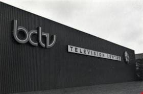
BCTV Television Centre
https://search.heritageburnaby.ca/link/archivedescription79344
- Repository
- City of Burnaby Archives
- Date
- September 22, 1976
- Collection/Fonds
- Burnaby Public Library Contemporary Visual Archive Project
- Description Level
- Item
- Physical Description
- 1 photograph : b&w ; 11 x 16 cm mounted on cardboard
- Scope and Content
- Photograph shows BCTV Television Centre on Enterprise Street in the Lake City Industrial Park.
- Repository
- City of Burnaby Archives
- Date
- September 22, 1976
- Collection/Fonds
- Burnaby Public Library Contemporary Visual Archive Project
- Physical Description
- 1 photograph : b&w ; 11 x 16 cm mounted on cardboard
- Description Level
- Item
- Record No.
- 556-254
- Access Restriction
- No restrictions
- Reproduction Restriction
- Reproduce for fair dealing purposes only
- Accession Number
- 2013-13
- Scope and Content
- Photograph shows BCTV Television Centre on Enterprise Street in the Lake City Industrial Park.
- Media Type
- Photograph
- Photographer
- McCarron, John
- Notes
- Scope note taken directly from BPL photograph description.
- 1 b&w copy negative : 10 x 12.5 cm accompanying
- Geographic Access
- Enterprise Street
- Planning Study Area
- Lake City Area
Images

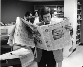
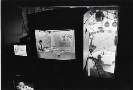
BCTV Television Centre
https://search.heritageburnaby.ca/link/archivedescription79346
- Repository
- City of Burnaby Archives
- Date
- September 22, 1976
- Collection/Fonds
- Burnaby Public Library Contemporary Visual Archive Project
- Description Level
- Item
- Physical Description
- 1 photograph : b&w ; 11 x 16 cm mounted on cardboard
- Scope and Content
- Photograph shows Tony Parsons, the anchor man on the BCTV six o'clock evening news, in the newsroom of BCTV Television Centre on Enterprise Street in the Lake City Industrial Park.
- Repository
- City of Burnaby Archives
- Date
- September 22, 1976
- Collection/Fonds
- Burnaby Public Library Contemporary Visual Archive Project
- Physical Description
- 1 photograph : b&w ; 11 x 16 cm mounted on cardboard
- Description Level
- Item
- Record No.
- 556-255
- Access Restriction
- No restrictions
- Reproduction Restriction
- Reproduce for fair dealing purposes only
- Accession Number
- 2013-13
- Scope and Content
- Photograph shows Tony Parsons, the anchor man on the BCTV six o'clock evening news, in the newsroom of BCTV Television Centre on Enterprise Street in the Lake City Industrial Park.
- Media Type
- Photograph
- Photographer
- McCarron, John
- Notes
- Scope note taken directly from BPL photograph description.
- 1 b&w copy negative : 10 x 12.5 cm accompanying
- Geographic Access
- Enterprise Street
- Planning Study Area
- Lake City Area
Images
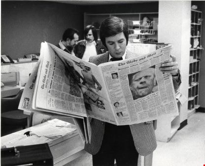
BCTV Television Centre
https://search.heritageburnaby.ca/link/archivedescription79347
- Repository
- City of Burnaby Archives
- Date
- September 22, 1976
- Collection/Fonds
- Burnaby Public Library Contemporary Visual Archive Project
- Description Level
- Item
- Physical Description
- 1 photograph : b&w ; 11 x 16 cm mounted on cardboard
- Scope and Content
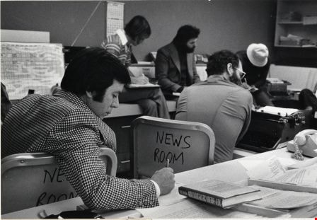
- Photograph shows Tony Parsons and other members of the BCTV news staff at a line-up meeting to determine what order the enws of the day will be in on the evening show.
- Repository
- City of Burnaby Archives
- Date
- September 22, 1976
- Collection/Fonds
- Burnaby Public Library Contemporary Visual Archive Project
- Physical Description
- 1 photograph : b&w ; 11 x 16 cm mounted on cardboard
- Description Level
- Item
- Record No.
- 556-256
- Access Restriction
- No restrictions
- Reproduction Restriction
- Reproduce for fair dealing purposes only
- Accession Number
- 2013-13
- Scope and Content
- Photograph shows Tony Parsons and other members of the BCTV news staff at a line-up meeting to determine what order the enws of the day will be in on the evening show.
- Media Type
- Photograph
- Photographer
- McCarron, John
- Notes
- Scope note taken directly from BPL photograph description.
- 1 b&w copy negative : 10 x 12.5 cm accompanying
- Geographic Access
- Enterprise Street
- Planning Study Area
- Lake City Area
Images
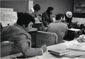
BCTV Television Centre
https://search.heritageburnaby.ca/link/archivedescription79348
- Repository
- City of Burnaby Archives
- Date
- September 22, 1976
- Collection/Fonds
- Burnaby Public Library Contemporary Visual Archive Project
- Description Level
- Item
- Physical Description
- 1 photograph : b&w ; 11 x 16 cm mounted on cardboard
- Scope and Content
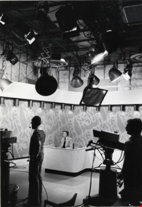
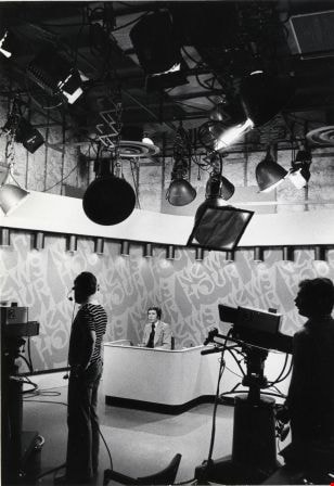
- Photograph shows BCTV cameramen and newsman Tony Parsons in the studio just prior to going on the air with the six o'clock evening news.
- Repository
- City of Burnaby Archives
- Date
- September 22, 1976
- Collection/Fonds
- Burnaby Public Library Contemporary Visual Archive Project
- Physical Description
- 1 photograph : b&w ; 11 x 16 cm mounted on cardboard
- Description Level
- Item
- Record No.
- 556-257
- Access Restriction
- No restrictions
- Reproduction Restriction
- Reproduce for fair dealing purposes only
- Accession Number
- 2013-13
- Scope and Content
- Photograph shows BCTV cameramen and newsman Tony Parsons in the studio just prior to going on the air with the six o'clock evening news.
- Media Type
- Photograph
- Photographer
- McCarron, John
- Notes
- Scope note taken directly from BPL photograph description.
- 1 b&w copy negative : 10 x 12.5 cm accompanying
- Geographic Access
- Enterprise Street
- Planning Study Area
- Lake City Area
Images
BCTV Television Centre
https://search.heritageburnaby.ca/link/archivedescription79349
- Repository
- City of Burnaby Archives
- Date
- September 22, 1976
- Collection/Fonds
- Burnaby Public Library Contemporary Visual Archive Project
- Description Level
- Item
- Physical Description
- 1 photograph : b&w ; 11 x 16 cm mounted on cardboard
- Scope and Content
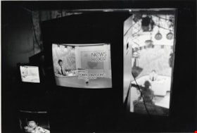
- Photograph shows monitors in the switching booth in the BCTV news studio just prior to the news broadcast going on the air.
- Repository
- City of Burnaby Archives
- Date
- September 22, 1976
- Collection/Fonds
- Burnaby Public Library Contemporary Visual Archive Project
- Physical Description
- 1 photograph : b&w ; 11 x 16 cm mounted on cardboard
- Description Level
- Item
- Record No.
- 556-258
- Access Restriction
- No restrictions
- Reproduction Restriction
- Reproduce for fair dealing purposes only
- Accession Number
- 2013-13
- Scope and Content
- Photograph shows monitors in the switching booth in the BCTV news studio just prior to the news broadcast going on the air.
- Media Type
- Photograph
- Photographer
- McCarron, John
- Notes
- Scope note taken directly from BPL photograph description.
- 1 b&w copy negative : 10 x 12.5 cm accompanying
- Geographic Access
- Enterprise Street
- Planning Study Area
- Lake City Area
Images

Looking southwest from corner of Douglas Road and Dominion Street
https://search.heritageburnaby.ca/link/archivedescription91877
- Repository
- City of Burnaby Archives
- Date
- 1978
- Collection/Fonds
- Small family fonds
- Description Level
- Item
- Physical Description
- 1 photograph : col. ; 9 cm x 13 cm
- Scope and Content
- Photograph of trees and a telephone pole situated at the southwest corner of Douglas Road and Dominion Street. The large oak, hemlock, and fir to the left of the telephone pole were planted as part of the original landscaping of the Roberts' property in the 1920s. The photograph was taken from th…
- Repository
- City of Burnaby Archives
- Date
- 1978
- Collection/Fonds
- Small family fonds
- Physical Description
- 1 photograph : col. ; 9 cm x 13 cm
- Description Level
- Item
- Record No.
- 620-058
- Access Restriction
- No restrictions
- Reproduction Restriction
- No reproduction permitted
- Accession Number
- 2017-01
- Scope and Content
- Photograph of trees and a telephone pole situated at the southwest corner of Douglas Road and Dominion Street. The large oak, hemlock, and fir to the left of the telephone pole were planted as part of the original landscaping of the Roberts' property in the 1920s. The photograph was taken from the Douglas Road and Dominion Street intersection.
- Media Type
- Photograph
- Notes
- Transcribed title
- Title transcribed from donor's notes
- Note in blue ink on verso of photograph reads: "P.20"
- Note in blue ink on verso of photograph reads: "Photo 1978"
- Note in black ink on verso of photograph reads: "Looking at S.W. corner of Douglas Rd and Dominion Street, from intersection / Oak tree, hemlock tree, and fir tree, Japanese Plum Tree"
- The oak tree is the same tree as in photographs 620-007, 620-014, 620-015, and 620-016
- Geographic Access
- Dominion Street
- Douglas Road
- Historic Neighbourhood
- Burnaby Lake (Historic Neighbourhood)
- Planning Study Area
- Ardingley-Sprott Area
Images

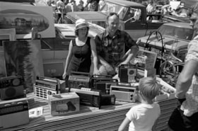
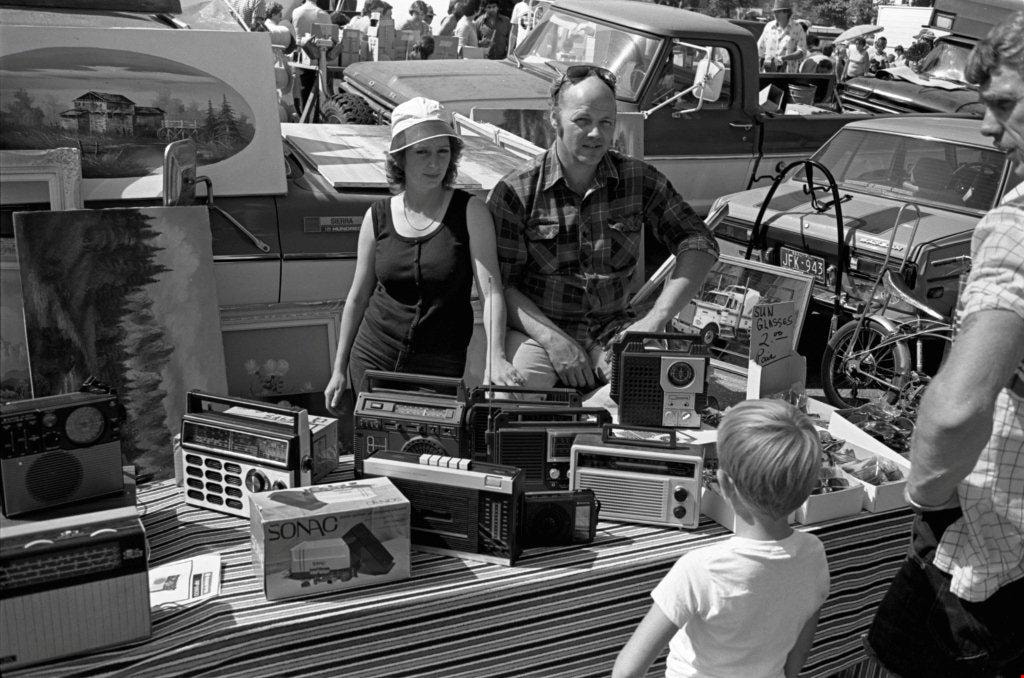
Radios, paintings and sunglasses
https://search.heritageburnaby.ca/link/archivedescription70282
- Repository
- City of Burnaby Archives
- Date
- 1978
- Collection/Fonds
- Bill Jeffries fonds
- Description Level
- Item
- Physical Description
- 1 photograph : b&w negative ; 35 mm
- Scope and Content
- Photograph of a table filled with radios and sunglasses at the Lougheed Drive-in swap meet in the summer of 1978. Paintings have been propped against a pickup truck behind the table and two unidentified vendors are behind the table with potential customers out in front.
- Repository
- City of Burnaby Archives
- Date
- 1978
- Collection/Fonds
- Bill Jeffries fonds
- Physical Description
- 1 photograph : b&w negative ; 35 mm
- Description Level
- Item
- Record No.
- 528-016
- Access Restriction
- No restrictions
- Reproduction Restriction
- No restrictions
- Accession Number
- 2011-01
- Scope and Content
- Photograph of a table filled with radios and sunglasses at the Lougheed Drive-in swap meet in the summer of 1978. Paintings have been propped against a pickup truck behind the table and two unidentified vendors are behind the table with potential customers out in front.
- Subjects
- Geographic Features - Automobile Parking Lots
- Transportation - Automobiles
- Arts - Paintings
- Telecommunication Tools and Equipment - Radios
- Media Type
- Photograph
- Photographer
- Jeffries, Bill
- Notes
- Title based on contents of item
- 1 b&w print (12.5 x 17.5 cm) accompanying
- Geographic Access
- Lougheed Highway
- Historic Neighbourhood
- Broadview (Historic Neighbourhood)
- Planning Study Area
- West Central Valley Area
Images

Radios, toasters and other electronic devices
https://search.heritageburnaby.ca/link/archivedescription70267
- Repository
- City of Burnaby Archives
- Date
- 1978
- Collection/Fonds
- Bill Jeffries fonds
- Description Level
- Item
- Physical Description
- 1 photograph : b&w negative ; 35 mm
- Scope and Content
- Photograph of a table filled with radios, toasters, sound equipment and other electronic devices at the Lougheed Drive-in swap meet in the summer of 1978. An unidentified vendor is standing at the table, looking away from the camera.
- Repository
- City of Burnaby Archives
- Date
- 1978
- Collection/Fonds
- Bill Jeffries fonds
- Physical Description
- 1 photograph : b&w negative ; 35 mm
- Description Level
- Item
- Record No.
- 528-001
- Access Restriction
- No restrictions
- Reproduction Restriction
- No restrictions
- Accession Number
- 2011-01
- Scope and Content
- Photograph of a table filled with radios, toasters, sound equipment and other electronic devices at the Lougheed Drive-in swap meet in the summer of 1978. An unidentified vendor is standing at the table, looking away from the camera.
- Subjects
- Geographic Features - Automobile Parking Lots
- Transportation - Automobiles
- Telecommunication Tools and Equipment - Radios
- Media Type
- Photograph
- Photographer
- Jeffries, Bill
- Notes
- Title based on contents of item
- Geographic Access
- Lougheed Highway
- Historic Neighbourhood
- Broadview (Historic Neighbourhood)
- Planning Study Area
- West Central Valley Area
Images

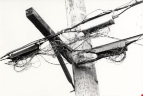
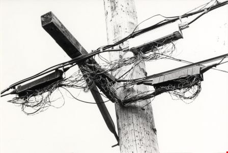
Telephone Pole
https://search.heritageburnaby.ca/link/archivedescription79867
- Repository
- City of Burnaby Archives
- Date
- July, 1976
- Collection/Fonds
- Burnaby Public Library Contemporary Visual Archive Project
- Description Level
- Item
- Physical Description
- 1 photograph : b&w ; 11 x 16 cm mounted on cardboard
- Scope and Content
- Photograph shows a jumble of wires on a telephone pole in Century Park.
- Repository
- City of Burnaby Archives
- Date
- July, 1976
- Collection/Fonds
- Burnaby Public Library Contemporary Visual Archive Project
- Physical Description
- 1 photograph : b&w ; 11 x 16 cm mounted on cardboard
- Description Level
- Item
- Record No.
- 556-469
- Access Restriction
- No restrictions
- Reproduction Restriction
- Reproduce for fair dealing purposes only
- Accession Number
- 2013-13
- Scope and Content
- Photograph shows a jumble of wires on a telephone pole in Century Park.
- Media Type
- Photograph
- Photographer
- Gardiner, Robert
- Notes
- Scope note taken directly from BPL photograph description.
- 1 b&w copy negative : 10 x 12.5 cm accompanying
- Geographic Access
- Deer Lake Avenue
- Street Address
- 6450 Deer Lake Avenue
- Historic Neighbourhood
- Burnaby Lake (Historic Neighbourhood)
- Planning Study Area
- Douglas-Gilpin Area
Images