More like 'Fire at Maywood Elementary School'
Narrow Results By
Decade
- 2020s 96
- 2010s 63
- 2000s 703
- 1990s 581
- 1980s 477
- 1970s
- 1960s 487
- 1950s 628
- 1940s 679
- 1930s 533
- 1920s 572
- 1910s 637
- 1900s
- 1890s 42
- 1880s 50
- 1870s 3
- 1860s 1
- 1850s 1
- 1840s 1
- 1830s 1
- 1820s 1
- 1810s 1
- 1800s 1
- 1790s 1
- 1780s 1
- 1770s 1
- 1760s 1
- 1750s 1
- 1740s 1
- 1730s 1
- 1720s 1
- 1710s 1
- 1700s 1
- 1690s 1
- 1680s 1
- 1670s 1
- 1660s 1
- 1650s 1
- 1640s 1
- 1630s 1
- 1620s 1
- 1610s 1
- 1600s 1
- 1520s 1

Duncan & Margaret McGregor Estate 'Glen-Lyon' Mansion
https://search.heritageburnaby.ca/link/landmark518
- Repository
- Burnaby Heritage Planning
- Description
- Overlooking the rich farmland of the Fraser River floodplain, 'Glen-Lyon' is an Edwardian era rural estate, with a tall, two and one-half storey plus basement wood-frame mansion, set in a pastoral and formal landscape with an associated barn and early log pond, located near a ravine and forested ar…
- Associated Dates
- 1902
- Formal Recognition
- Heritage Designation, Community Heritage Register
- Street View URL
- Google Maps Street View
- Repository
- Burnaby Heritage Planning
- Geographic Access
- Marine Drive
- Associated Dates
- 1902
- Formal Recognition
- Heritage Designation, Community Heritage Register
- Enactment Type
- Bylaw No. 12183
- Enactment Date
- 11/12/2006
- Description
- Overlooking the rich farmland of the Fraser River floodplain, 'Glen-Lyon' is an Edwardian era rural estate, with a tall, two and one-half storey plus basement wood-frame mansion, set in a pastoral and formal landscape with an associated barn and early log pond, located near a ravine and forested area adjacent to Marine Drive in South Burnaby.
- Heritage Value
- ‘Glen-Lyon’ is valued as an excellent example of a privately-owned Edwardian era country estate built at the turn of the nineteenth century. The property retains significant heritage features including the Edwardian era mansion with rustic Arts and Crafts features, and elements of a working agricultural landscape. The property was originally the Royal City Mills logging camp, and in 1900 was purchased by Duncan Campbell McGregor (1853-1929) and Margaret Jane McGregor (1875-1960), who named their estate ‘Glen-Lyon’ after Duncan McGregor’s birthplace in Perthshire, Scotland. The McGregors were active in municipal affairs and social activities, and played a significant role in the early development of Burnaby. Duncan McGregor served as a city councillor from 1909 to 1912 and was elected reeve of Burnaby in 1913. Margaret McGregor was instrumental in the formation and fundraising activities of the Victoria Order of Nurses in Burnaby. Additionally, the site is historically significant for its association with early social welfare and correctional reform. The estate was sold in 1926 to an inter-denominational religious organization called the Home of the Friendless, which used it as their B.C. headquarters. The organization was charged with several cases of abuse and neglect in 1937, after which a Royal Commission was formed that led to new legislation to regulate and license all private welfare institutions. 'Glen-Lyon' was sold to the provincial government, and was dedicated in 1939 by the Lt.-Gov. E.W. Hamber for use as the New Haven Borstal Home for Boys and Youthful Offenders (later renamed the New Haven Correction Centre). The Borstal movement originated in England in the late nineteenth century, as an alternative to sending young offenders and runaways to prisons by providing reformatories that focused on discipline and vocational skill. This site’s role as the first North American institution devoted to the Borstal School philosophy was historic, and influenced corrections programs across Canada. The site retains significant features from its development in 1939 as the Borstal School, including a large gambrel-roofed barn designed by Chief Provincial Architect Henry Whittaker of the Department of Public Works that is the only remaining structure of its kind in Burnaby. Between 1941 and 1945 the mansion housed the Provincial School for the Deaf and Blind when the Borstal School was closed temporarily as a war measure during the Second World War.
- Defining Elements
- Key elements that define the heritage character of 'Glen-Lyon' Mansion include its: - location on a sloping site with expansive southern exposure, adjacent to Marine Drive - residential form, scale and massing of the house as exemplified by its two and one-half storey height, above-ground basement and rectangular plan - Arts and Crafts elements of the house such as its stone foundation, multi-gabled roof line with steep central hipped roof, symmetrical cross-gables, side shed dormers, bellcast upper walls sheathed in cedar shingles and lower walls sheathed in narrow clapboard - original exterior features of the house such as the full width front verandah with square columns, central staircase on the southern elevation, original doors and stained glass windows; and the irregular fenestration such as double-hung 1-over-1 wooden-sash windows, bay windows, and projecting windows in the gable ends - original interior features of the house such as the U-shaped main stair designed around two symmetrically placed Ionic columns, and interior trim on the main floor including boxed beams and fireplaces - gambrel-roofed barn with roof vent with finial, sliding hay loft and access doors, small multi-pane windows, and lapped wooden siding - associated landscape features such as the original garden plantings with some exotic and many native specimen trees; the original log pond and its concrete Marine Drive causeway and culvert; rockeries and a rose garden
- Historic Neighbourhood
- Fraser Arm (Historic Neighbourhood)
- Planning Study Area
- Big Bend Area
- Architect
- Henry Whittaker
- Function
- Primary Historic--Estate
- Community
- Burnaby
- Cadastral Identifier
- 003-004-661
- Boundaries
- 'Glen-Lyon' is comprised of a single residential lot located at 4250 Marine Drive, Burnaby.
- Area
- 230873.18
- Contributing Resource
- Building
- Ownership
- Private
- Names
- McGregor, Duncan C. (1853-1929)
- Whittaker, Henry
- Home of the Friendless
- Borstal School
- New Haven Correction Centre
- Subjects
- Buildings - Heritage
- Buildings - Residential - Houses
- Buildings - Public - Detention Facilities
- Buildings - Residential
- Street Address
- 4250 Marine Drive
- Street View URL
- Google Maps Street View
Images


H.T. Ceperley Estate 'Fairacres' Steam Plant Building
https://search.heritageburnaby.ca/link/landmark528
- Repository
- Burnaby Heritage Planning
- Description
- Designed in the British Arts and Crafts style, the ‘Fairacres’ Steam Plant Buiding is a single-storey wood frame building with a gabled roof that originally housed the apparatus for climate control in the greenhouses, formerly located to its north. The original rubble stone walls that formed the fo…
- Associated Dates
- 1908
- Formal Recognition
- Heritage Designation, Community Heritage Register
- Repository
- Burnaby Heritage Planning
- Geographic Access
- Deer Lake Avenue
- Associated Dates
- 1908
- Formal Recognition
- Heritage Designation, Community Heritage Register
- Enactment Type
- Bylaw No. 9807
- Enactment Date
- 23/11/1992
- Description
- Designed in the British Arts and Crafts style, the ‘Fairacres’ Steam Plant Buiding is a single-storey wood frame building with a gabled roof that originally housed the apparatus for climate control in the greenhouses, formerly located to its north. The original rubble stone walls that formed the foundation for the greenhouses stand adjacent. The Steam Plant Building stands as a pendant to the Root House, which is to the north of the former greenhouses.
- Heritage Value
- The outbuildings at 'Fairacres' are a rare surviving architecturally-designed ensemble of agricultural structures that exist in complementary harmony with the main estate house. Architect Robert Mackay Fripp (1858-1917), an outspoken advocate of Arts and Crafts design, was retained by the Ceperleys to design several original outbuildings on their estate. The Ceperleys operated 'Fairacres' with staff, a farm manager and workers, including Chinese, to grow produce for themselves and for sale at local markets. The Steam Plant Building illustrates the market gardening activity of the area around Deer Lake and its importance to the Ceperley family, which valued a year-round supply of fresh fruit and vegetables for the kitchen and flowers for the house. It also illustrates the cultural and aesthetic values of the Ceperleys in retaining an architect to design a functional outbuilding using an accepted and contemporary architectural style. Built in 1908, the Steam Plant Building was significantly altered in the 1960s and restored to its original design in 2000.
- Defining Elements
- Key elements that define the heritage character of the ‘Fairacres’ Steam Plant Building include its: - overall spatial arrangement of the Steam Plant Building in relation to the former greenhouses and the Root House - side gable roof with cedar shingle cladding. - tall brick chimney indicitive of the building's original function. - distinctive Arts and Crafts architectural features such as the shingle wall cladding with decorative shingling under window sills, deep eaves, and pebble-dashed concrete foundation walls - six-paned wooden-sash casement windows - simple functional interior features - rubble stone walls that formed the foundation for the greenhouses
- Locality
- Deer Lake Park
- Historic Neighbourhood
- Burnaby Lake (Historic Neighbourhood)
- Planning Study Area
- Douglas-Gilpin Area
- Architect
- Robert Mackay Fripp
- Function
- Primary Historic--Outbuilding
- Community
- Burnaby
- Cadastral Identifier
- P.I.D. No. 004-493-311 Legal Description: Block 3 Except: Part subdivided by Plan 26865, District Lot 79, Group 1, New Westminster District, Plan 536
- Boundaries
- ‘Fairacres’ is comprised of a single municipally-owned property located at 6344 Deer Lake Avenue, Burnaby.
- Area
- 17,065.00
- Contributing Resource
- Building
- Landscape Feature
- Ownership
- Public (local)
- Other Collection
- Burnaby Historical Society, Community Archives: Ceperley Photograph Album
- Documentation
- Heritage Site Files: PC77000 20. City of Burnaby Planning and Building Department, 4949 Canada Way, Burnaby, B.C., V5G 1M2
- Street Address
- 6344 Deer Lake Avenue
Images


H.T. Ceperley Estate 'Fairacres' Greenhouse Foundation Wall
https://search.heritageburnaby.ca/link/landmark862
- Repository
- Burnaby Heritage Planning
- Description
- The original rubble stone walls that formed the foundation for a greenhouses adjacent to the Steam Plant Building provided heat to several greenhouses on the estate propoerty. The Root House, which is to the north of the Greenhouse Foundation Wall, provided storage for the farm operation.
- Associated Dates
- 1908
- Formal Recognition
- Heritage Designation, Community Heritage Register
- Repository
- Burnaby Heritage Planning
- Geographic Access
- Deer Lake Avenue
- Associated Dates
- 1908
- Formal Recognition
- Heritage Designation, Community Heritage Register
- Enactment Type
- Bylaw No. 140665
- Enactment Date
- 23/11/1992
- Description
- The original rubble stone walls that formed the foundation for a greenhouses adjacent to the Steam Plant Building provided heat to several greenhouses on the estate propoerty. The Root House, which is to the north of the Greenhouse Foundation Wall, provided storage for the farm operation.
- Heritage Value
- The outbuildings at 'Fairacres' are a rare surviving architecturally-designed ensemble of agricultural structures that exist in complementary harmony with the main estate house. Architect Robert Mackay Fripp (1858-1917), an outspoken advocate of Arts and Crafts design, was retained by the Ceperleys to design several original outbuildings on their estate, which was designed as a country estate with a working farm that included over 10 acres of productive berry and vegetable fields, with a large kitchen garden, a root house to store food, an orchard, and greenhouses heated by steam. The agricultural potential of the Deer Lake area made it one of the first parts of the municipality to attract settlement. In 1909, the Ceperleys built three large greenhouses heated by an adjacent steam plant (Fairacres Steam Plant). The greenhouses featured granite foundation walls, including this one which remains intact. The Ceperleys employed a large staff to manage the estate's agricultural production, including Chinese farm labourers. Produce was grown for use at the estate, and for sale at local markets. Agricultural use of the estate continued when a Catholic order of Benedictine monks purchased the estate as part of the Priory of St. Joseph and the Seminary of Christ the King, and continued to farm the land until 1953.
- Defining Elements
- Key elements that define the heritage character of the ‘Fairacres’ Steam Plant Building include its: - overall spatial arrangement of the Greenhouse Foundation Wall in relation to the Steam Plant Building and the Root House - original rubble stone walls reflecting the Arts and Crafts design aesthetic of the estate buildings.
- Locality
- Deer Lake Park
- Historic Neighbourhood
- Burnaby Lake (Historic Neighbourhood)
- Planning Study Area
- Douglas-Gilpin Area
- Architect
- Robert Mackay Fripp
- Function
- Primary Historic--Outbuilding
- Community
- Burnaby
- Cadastral Identifier
- P.I.D. No. 004-493-311 Legal Description: Block 3 Except: Part subdivided by Plan 26865, District Lot 79, Group 1, New Westminster District, Plan 536
- Boundaries
- ‘Fairacres’ is comprised of a single municipally-owned property located at 6344 Deer Lake Avenue, Burnaby.
- Area
- 17,065.00
- Contributing Resource
- Landscape Feature
- Remains
- Ownership
- Public (local)
- Other Collection
- Burnaby Historical Society, Community Archives: Ceperley Photograph Album
- Documentation
- Heritage Site Files: PC77000 20. City of Burnaby Planning and Building Department, 4949 Canada Way, Burnaby, B.C., V5G 1M2
- Street Address
- 6344 Deer Lake Avenue
Images


H.T. Ceperley Estate 'Fairacres' Root House
https://search.heritageburnaby.ca/link/landmark527
- Repository
- Burnaby Heritage Planning
- Description
- The ‘Fairacres’ Root House is a long, low one-storey masonry building, measuring 4.6 metres by 9.1 metres, with massively buttressed concrete walls and foundations. Built into sloping ground adjacent to the location of the former greenhouses, the surviving orchard and the kitchen entrance of the ma…
- Associated Dates
- 1908
- Formal Recognition
- Heritage Designation, Community Heritage Register
- Repository
- Burnaby Heritage Planning
- Geographic Access
- Deer Lake Avenue
- Associated Dates
- 1908
- Formal Recognition
- Heritage Designation, Community Heritage Register
- Enactment Type
- Bylaw No. 9807
- Enactment Date
- 23/11/1992
- Description
- The ‘Fairacres’ Root House is a long, low one-storey masonry building, measuring 4.6 metres by 9.1 metres, with massively buttressed concrete walls and foundations. Built into sloping ground adjacent to the location of the former greenhouses, the surviving orchard and the kitchen entrance of the main house, 'Fairacres,' this functional structure was used as a frost-free store for fruit and vegetables for the family's use.
- Heritage Value
- The outbuildings at 'Fairacres' are a rare surviving architecturally-designed ensemble of agricultural structures that exist in complementary harmony with the main estate house. Architect Robert Mackay Fripp (1858-1917), an outspoken advocate of Arts and Crafts design, was retained by the Ceperleys to design several original outbuildings on their estate. The Root House is important as a rare surviving, and exceptionally large, example of this building type in the Vancouver region. Unusual in the fact that an architect designed a building of such modest aspirations, it is also remarkable in its method of construction. The use of concrete as a structural material is one of the earliest in the region and extraordinary for its use on such a modest vernacular outbuilding; root cellars were typically built of loose stone. Built in 1908, the Root House was significantly altered in the 1960s and restored to its original design in 2000. The building is significant as an indicator of the market gardening activity in the area around Deer Lake and of the country-house self-sufficiency practiced by the Ceperley family. The Root House illustrates the cultural, aesthetic, and lifestyle values of the Ceperleys in constructing such a large building for storing their own produce.
- Defining Elements
- The outbuildings at 'Fairacres' are a rare surviving architecturally-designed ensemble of agricultural structures that exist in complementary harmony with the main estate house. Architect Robert Mackay Fripp (1858-1917), an outspoken advocate of Arts and Crafts design, was retained by the Ceperleys to design several original outbuildings on their estate. The Root House is important as a rare surviving, and exceptionally large, example of this building type in the Vancouver region. Unusual in the fact that an architect designed a building of such modest aspirations, it is also remarkable in its method of construction. The use of concrete as a structural material is one of the earliest in the region and extraordinary for its use on such a modest vernacular outbuilding; root cellars were typically built of loose stone. Built in 1908, the Root House was significantly altered in the 1960s and restored to its original design in 2000. The building is significant as an indicator of the market gardening activity in the area around Deer Lake and of the country-house self-sufficiency practiced by the Ceperley family. The Root House illustrates the cultural, aesthetic, and lifestyle values of the Ceperleys in constructing such a large building for storing their own produce.
- Locality
- Deer Lake Park
- Historic Neighbourhood
- Burnaby Lake (Historic Neighbourhood)
- Planning Study Area
- Douglas-Gilpin Area
- Architect
- Robert Mackay Fripp
- Function
- Primary Historic--Outbuilding
- Secondary Historic--Food Storage
- Community
- Burnaby
- Cadastral Identifier
- P.I.D. No. 004-493-311 Legal Description: Block 3 Except: Part subdivided by Plan 26865, District Lot 79, Group 1, New Westminster District, Plan 536
- Boundaries
- ‘Fairacres’ is comprised of a single municipally-owned property located at 6344 Deer Lake Avenue, Burnaby.
- Area
- 17,065.00
- Contributing Resource
- Building
- Landscape Feature
- Ownership
- Public (local)
- Other Collection
- Burnaby Historical Society, Community Archives: Ceperley Photograph Album
- Documentation
- Heritage Site Files: PC77000 20. City of Burnaby Planning and Building Department, 4949 Canada Way, Burnaby, B.C., V5G 1M2
- Street Address
- 6344 Deer Lake Avenue
Images


Burnaby mill fire
https://search.heritageburnaby.ca/link/archivedescription45458
- Repository
- City of Burnaby Archives
- Date
- 1979
- Collection/Fonds
- Columbian Newspaper collection
- Description Level
- Item
- Physical Description
- 1 photograph : b&w ; 17 x 24 cm
- Scope and Content
- Photograph of a Burnaby planner and chipper mill that caught on fire. Two firemen are visible in the foreground, silhouetted against the flames.
- Repository
- City of Burnaby Archives
- Date
- 1979
- Collection/Fonds
- Columbian Newspaper collection
- Physical Description
- 1 photograph : b&w ; 17 x 24 cm
- Description Level
- Item
- Record No.
- 480-353
- Access Restriction
- No restrictions
- Reproduction Restriction
- Reproduce for fair dealing purposes only
- Accession Number
- 2003-02
- Scope and Content
- Photograph of a Burnaby planner and chipper mill that caught on fire. Two firemen are visible in the foreground, silhouetted against the flames.
- Media Type
- Photograph
- Photographer
- Hodge, Craig
- Notes
- Title based on contents of photograph
- Newspaper clipping attached to verso of photograph reads: "BURNABY MILL BURNS ... Burnaby firefighters are silhouetted by flames ripping through a planer and chipper mill early this morning at 5744 Byrne Road. The fire was contained in the main building of the $500,000 mill. Damage has been estimated at $200,000. The cause of the fire is under investigation."
- Geographic Access
- Byrne Road
- Street Address
- 5744 Byrne Road
- Historic Neighbourhood
- Fraser Arm (Historic Neighbourhood)
- Planning Study Area
- Big Bend Area
Images

Interview with Bob Lowe 2005 - Track 4
https://search.heritageburnaby.ca/link/museumdescription4496
- Repository
- Burnaby Village Museum
- Date
- 1930-1949 (interview content), interviewed May 2005
- Collection/Fonds
- Burnaby Village Museum fonds
- Description Level
- Item
- Physical Description
- 1 sound recording (mp3) (0:07:21 min)
- Scope and Content
- Track 4: This portion of the recording pertains to Bob’s best and worst memories of his childhood, and cultural differences in his community. Bob recalls participation in favourite activities as his best memories, and notes that children of the time were not restricted in their play. He talks of ma…
- Repository
- Burnaby Village Museum
- Collection/Fonds
- Burnaby Village Museum fonds
- Series
- Museum Oral Histories series
- Subseries
- Growing Up in Burnaby subseries
- Description Level
- Item
- Physical Description
- 1 sound recording (mp3) (0:07:21 min)
- Material Details
- Interviewer: Tom Gooden Interviewee: Bob Lowe Date of interview: May 2005 Total Number of Tracks: 6 Total length of all Tracks: 0:43:36
- Scope and Content
- Track 4: This portion of the recording pertains to Bob’s best and worst memories of his childhood, and cultural differences in his community. Bob recalls participation in favourite activities as his best memories, and notes that children of the time were not restricted in their play. He talks of making an enterprise of harvesting and selling cascara bark during WWII, when prices rose. Bob describes his worst memories, which are of fires, a flood, and bad fog, and how he was nearly killed as a passenger in a wagon whose horse bolted. He recalls that his family was a minority among the Ukrainian families in the neighborhood.
- History
- Recording of an interview with Bob Lowe recording by Tom Gooden in 2005. This recording was completed for an exhibit, Growing Up in Burnaby, for the Burnaby Village Museum. Major themes discussed are growing up in Burnaby in the 1930s and 40s.
- Creator
- Burnaby Village Museum
- Names
- Lowe, Robert "Bob"
- Accession Code
- BV017.45.6
- Access Restriction
- No restrictions
- Reproduction Restriction
- May be restricted by third party rights
- Date
- 1930-1949 (interview content), interviewed May 2005
- Media Type
- Sound Recording
- Notes
- Title based on contents of item
Audio Tracks
Interview with Bob Lowe 2005 - Track 4, 1930-1949 (interview content), interviewed May 2005
Interview with Bob Lowe 2005 - Track 4, 1930-1949 (interview content), interviewed May 2005
https://search.heritageburnaby.ca/media/hpo/_Data/_BVM_Sound_Recordings/Oral_Histories/2017_0045_0006_004.mp3
Mills Burning at Barnet
https://search.heritageburnaby.ca/link/archivedescription38342
- Repository
- City of Burnaby Archives
- Date
- May 6, 1909
- Collection/Fonds
- Burnaby Historical Society fonds
- Description Level
- Item
- Physical Description
- 1 photograph : sepia postcard ; 8 x 13.4 cm
- Scope and Content
- Photographic postcard of the line of buildings burning at the North Pacific Lumber Company, with flames and smoke visible rising from the structures. A caption stamped at the top of the postcard reads: "Mills burning at Barnet BC. 1:30a.m. May 6th, 1909."
- Repository
- City of Burnaby Archives
- Date
- May 6, 1909
- Collection/Fonds
- Burnaby Historical Society fonds
- Subseries
- Charles Lee subseries
- Physical Description
- 1 photograph : sepia postcard ; 8 x 13.4 cm
- Description Level
- Item
- Record No.
- 411-001
- Access Restriction
- No restrictions
- Reproduction Restriction
- No known restrictions
- Accession Number
- BHS2000-13
- Scope and Content
- Photographic postcard of the line of buildings burning at the North Pacific Lumber Company, with flames and smoke visible rising from the structures. A caption stamped at the top of the postcard reads: "Mills burning at Barnet BC. 1:30a.m. May 6th, 1909."
- Names
- Barnet Mill
- Media Type
- Photograph
- Geographic Access
- Barnet Village
- Texaco Drive
- Street Address
- 8059 Texaco Drive
- Historic Neighbourhood
- Barnet (Historic Neighbourhood)
- Planning Study Area
- Burnaby Mountain Area
Images


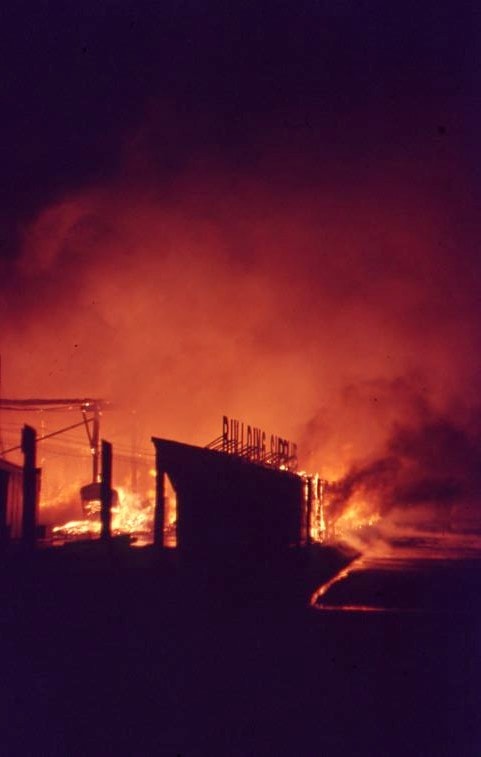
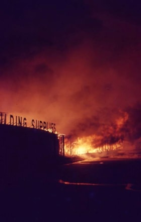
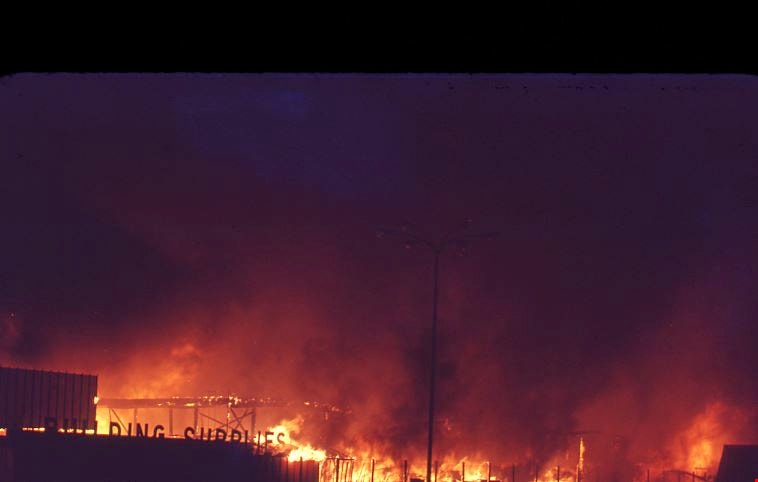
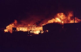
Nighttime fire at Lumberland
https://search.heritageburnaby.ca/link/museumdescription4312
- Repository
- Burnaby Village Museum
- Date
- 24 Aug. 1970
- Collection/Fonds
- Burnaby Village Museum Photograph collection
- Description Level
- Item
- Physical Description
- 1 photograph : col. ; 35 mm
- Scope and Content
- Photograph of a nighttime fire at Lumberland, located at 5650 Lougheed Highway.
- Repository
- Burnaby Village Museum
- Collection/Fonds
- Burnaby Village Museum Photograph collection
- Description Level
- Item
- Physical Description
- 1 photograph : col. ; 35 mm
- Material Details
- The slide was processed in Canachrome by Mortifee.
- Handwritten text in ink on slide frame reads: "Lumberland / Aug 24 /70".
- Scope and Content
- Photograph of a nighttime fire at Lumberland, located at 5650 Lougheed Highway.
- Names
- Farmer, Joanne
- Lumberland
- Geographic Access
- Lougheed Highway
- Street Address
- 5650 Lougheed Highway
- Accession Code
- BV017.42.7
- Access Restriction
- No restrictions
- Reproduction Restriction
- No known restrictions
- Date
- 24 Aug. 1970
- Media Type
- Photograph
- Planning Study Area
- Dawson-Delta Area
- Scan Resolution
- 600
- Scan Date
- 05-Jun-2018
- Notes
- Title based on content of photograph.
Images
Nighttime fire at Lumberland
https://search.heritageburnaby.ca/link/museumdescription4313
- Repository
- Burnaby Village Museum
- Date
- 24 Aug. 1970
- Collection/Fonds
- Burnaby Village Museum Photograph collection
- Description Level
- Item
- Physical Description
- 1 photograph : col. ; 35 mm
- Scope and Content
- Photograph of a nighttime fire at Lumberland, located at 5650 Lougheed Highway.
- Repository
- Burnaby Village Museum
- Collection/Fonds
- Burnaby Village Museum Photograph collection
- Description Level
- Item
- Physical Description
- 1 photograph : col. ; 35 mm
- Material Details
- The slide was processed in Canachrome by Mortifee.
- Handwritten text in ink on slide frame reads: "Lumberland / Fire Aug 24 /70".
- Scope and Content
- Photograph of a nighttime fire at Lumberland, located at 5650 Lougheed Highway.
- Names
- Farmer, Joanne
- Lumberland
- Geographic Access
- Lougheed Highway
- Street Address
- 5650 Lougheed Highway
- Accession Code
- BV017.42.8
- Access Restriction
- No restrictions
- Reproduction Restriction
- No known restrictions
- Date
- 24 Aug. 1970
- Media Type
- Photograph
- Planning Study Area
- Dawson-Delta Area
- Scan Resolution
- 600
- Scan Date
- 05-Jun-2018
- Notes
- Title based on contents of photograph
Images


Nighttime fire at Lumberland
https://search.heritageburnaby.ca/link/museumdescription4314
- Repository
- Burnaby Village Museum
- Date
- 24 Aug. 1970
- Collection/Fonds
- Burnaby Village Museum Photograph collection
- Description Level
- Item
- Physical Description
- 1 photograph : col. ; 35 mm
- Scope and Content
- Photograph of a nighttime fire at Lumberland, located at 5650 Lougheed Highway.
- Repository
- Burnaby Village Museum
- Collection/Fonds
- Burnaby Village Museum Photograph collection
- Description Level
- Item
- Physical Description
- 1 photograph : col. ; 35 mm
- Material Details
- The slide was processed in Canachrome by Mortifee.
- Handwritten text in ink on slide frame reads: "Lumberland Fire / Aug 24 /70".
- Scope and Content
- Photograph of a nighttime fire at Lumberland, located at 5650 Lougheed Highway.
- Names
- Farmer, Joanne
- Lumberland
- Geographic Access
- Lougheed Highway
- Street Address
- 5650 Lougheed Highway
- Accession Code
- BV017.42.9
- Access Restriction
- No restrictions
- Reproduction Restriction
- No known restrictions
- Date
- 24 Aug. 1970
- Media Type
- Photograph
- Planning Study Area
- Dawson-Delta Area
- Scan Resolution
- 600
- Scan Date
- 05-Jun-2018
- Notes
- Title based on contents of photograph
Images
Nighttime fire at Lumberland
https://search.heritageburnaby.ca/link/museumdescription4315
- Repository
- Burnaby Village Museum
- Date
- 24 Aug. 1970
- Collection/Fonds
- Burnaby Village Museum Photograph collection
- Description Level
- Item
- Physical Description
- 1 photograph : col. ; 35 mm
- Scope and Content
- Photograph of a nighttime fire at Lumberland, located at 5650 Lougheed Highway.
- Repository
- Burnaby Village Museum
- Collection/Fonds
- Burnaby Village Museum Photograph collection
- Description Level
- Item
- Physical Description
- 1 photograph : col. ; 35 mm
- Material Details
- The slide was processed in Canachrome by Mortifee.
- Handwritten text in ink on slide frame reads: "Lumberland / Fire Aug 24 /70".
- Scope and Content
- Photograph of a nighttime fire at Lumberland, located at 5650 Lougheed Highway.
- Other Title Information
- Title based on content of photograph.
- Names
- Farmer, Joanne
- Lumberland
- Geographic Access
- Lougheed Highway
- Street Address
- 5650 Lougheed Highway
- Accession Code
- BV017.42.10
- Access Restriction
- No restrictions
- Reproduction Restriction
- No known restrictions
- Date
- 24 Aug. 1970
- Media Type
- Photograph
- Planning Study Area
- Dawson-Delta Area
- Scan Resolution
- 600
- Scan Date
- 05-Jun-2018
- Notes
- Title based on contents of photograph
Images


Speech given by Florence Hart Godwin May 28, 1973 - Track 5
https://search.heritageburnaby.ca/link/oralhistory282
- Repository
- City of Burnaby Archives
- Date Range
- 1898-1917
- Length
- 0:05:22
- Summary
- This portion of the recording pertains to Florence (Hart) Godwin's description of her family's stories of the New Westminster fire. She also mentions B.R. Hill and his three sons, Claude, Frank and Minard Hill.
- Repository
- City of Burnaby Archives
- Summary
- This portion of the recording pertains to Florence (Hart) Godwin's description of her family's stories of the New Westminster fire. She also mentions B.R. Hill and his three sons, Claude, Frank and Minard Hill.
- Date Range
- 1898-1917
- Photo Info
- Arthur Morrow, Kingsley Hart, Florence Hart (later Godwin), and Katherine Maude "Kitty" Hill (later Peers) in the woods at the south side of Deer Lake photographed by W.T. Cooksley [1908]. Item no. HV976.139.3
- Length
- 0:05:22
- Subjects
- Natural Phenomena - Fires
- Interviewer
- Burnaby Arts Council
- Interview Date
- May 28, 1973
- Scope and Content
- Recording is of a speech given by Florence Hart Godwin at a Burnaby Arts Council meeting held May 28, 1973. Major themes discussed are: pioneer families and early residences in the Burnaby Lake District.
- Biographical Notes
- Florence Hart was born in 1898 in New Westminster. Florence first saw Burnaby in April of 1905 on a trip made by horse and buggy from the family home in New Westminster where her father worked as a real estate agent. By 1911, he had built a permanent home for his family in Burnaby, building what is now known as the Hart house and is currently owned by the municipality. Frederick John “Fred” Hart married Alice Chapman in Yale BC on August 13, 1895. They had four children together; Kingsley Chapman born May 27, 1897, Florence Elizabeth born October 23, 1898, and ten years later, Edwyna and Jack. They followed their family nurse, Miss Maude Woodward to Burnaby and purchased thirteen acres of land at Deer Lake to build a summer cottage. Mrs Hill and the children spent the summer months there while Frederick continued working in New Westminster, joining his family on the weekends. Florence Hart attended Douglas Road School before boarding at Crofton House in Vancouver. Kingsley Hart had enlisted in the army on March 23, 1915 when he was only seventeen years old. He was killed in action on September 26, 1916. The Hart family then moved to Kerrisdale, Vancouver. Florence worked at the Carnegie Library. On August 7, 1922 Florence Hart married Harold “Hal” Godwin and moved back to Edmonds in Burnaby where they remained for their entire married lives. In 1929, Florence and Harold’s daughter, Elizabeth Godwin was born. Alice (Chapman) Hart died May 24, 1935 at the age of sixty-eight. Frederick John Hart died August 29, 1945 at the age of seventy-seven. Florence Hart Godwin was named Good Citizen of Burnaby in 1971 and received a life membership to the IODE (Imperial Order Daughters of the Empire) for her long tenure. Both Florence and her husband Harold were awarded life memberships from the VON (Victorian Order of Nurses) for more than half a century of service. Harold Ward Godwin died December 12, 1962 at the age of sixty-six.
- Total Tracks
- 5
- Total Length
- 0:33:50
- Interviewee Name
- Godwin, Florence Hart
- Collection/Fonds
- Burnaby Historical Society fonds
- Subseries
- Oral history subseries
- Transcript Available
- None
- Media Type
- Sound Recording
- Web Notes
- Interview was digitized in 2010 allowing it to be accessible on Heritage Burnaby. The digitization project was initiated by the Community Heritage Commission with support from City of Burnaby Council and the BC History Digitization Program of the Irving K. Barber Learning Centre, University of British Columbia. It was recognized by the Heritage Society of BC with an award in 2012.
Images

Audio Tracks
Track five of speech given by Florence Hart Godwin
Track five of speech given by Florence Hart Godwin
https://search.heritageburnaby.ca/media/hpo/_Data/_Archives_Oral_Histories/_Unrestricted/MSS137-005-1/MSS137-005-1_Track_5.mp3![Burnaby Fire Department rescue truck, [after 1976] thumbnail](/media/hpo/_Data/_BVM_Images/2000/200200100004.jpg?width=280)
Burnaby Fire Department rescue truck
https://search.heritageburnaby.ca/link/museumdescription1606
- Repository
- Burnaby Village Museum
- Date
- [after 1976]
- Collection/Fonds
- Burnaby Village Museum Photograph collection
- Description Level
- Item
- Physical Description
- 1 photograph : b&w ; 25 x 25.5 cm
- Scope and Content
- Photograph of an unidentified fireman walking towards the open door of Burnaby Fire Department's Rescue 1 truck (1976 Ford C 600 Rescue unit). Seven other unidentified men are visible standing in the background.
- Repository
- Burnaby Village Museum
- Collection/Fonds
- Burnaby Village Museum Photograph collection
- Description Level
- Item
- Physical Description
- 1 photograph : b&w ; 25 x 25.5 cm
- Scope and Content
- Photograph of an unidentified fireman walking towards the open door of Burnaby Fire Department's Rescue 1 truck (1976 Ford C 600 Rescue unit). Seven other unidentified men are visible standing in the background.
- Names
- Burnaby Fire Department
- Accession Code
- BV002.10.4
- Access Restriction
- Restricted access
- Reproduction Restriction
- May be restricted by third party rights
- Date
- [after 1976]
- Media Type
- Photograph
- Related Material
- For another photograph of the rescue truck taken from a different angle, see BV002.10.5
- Scan Resolution
- 600
- Scan Date
- 09-Jun-09
- Scale
- 100
- Notes
- Title based on contents of photograph
Images
![Burnaby Fire Department rescue truck, [after 1976] thumbnail](/media/hpo/_Data/_BVM_Images/2000/200200100004.jpg)
![Burnaby Fire Department rescue truck, [after 1976] thumbnail](/media/hpo/_Data/_BVM_Images/2000/200200100005.jpg?width=280)
Burnaby Fire Department rescue truck
https://search.heritageburnaby.ca/link/museumdescription1607
- Repository
- Burnaby Village Museum
- Date
- [after 1976]
- Collection/Fonds
- Burnaby Village Museum Photograph collection
- Description Level
- Item
- Physical Description
- 1 photograph : b&w ; 20.5 x 25.2 cm
- Scope and Content
- Photograph of four unidentified firemen gathered beside Burnaby Fire Department's Rescue 1 truck (1976 Ford C 600 Rescue unit). The truck's side compartments are visible, housing fire extinguishers and other equipment. The truck appears to be parked at fire hall no. 1 at Sperling and Canada Way.
- Repository
- Burnaby Village Museum
- Collection/Fonds
- Burnaby Village Museum Photograph collection
- Description Level
- Item
- Physical Description
- 1 photograph : b&w ; 20.5 x 25.2 cm
- Scope and Content
- Photograph of four unidentified firemen gathered beside Burnaby Fire Department's Rescue 1 truck (1976 Ford C 600 Rescue unit). The truck's side compartments are visible, housing fire extinguishers and other equipment. The truck appears to be parked at fire hall no. 1 at Sperling and Canada Way.
- Names
- Burnaby Fire Department
- Geographic Access
- Canada Way
- Sperling Avenue
- Accession Code
- BV002.10.5
- Access Restriction
- Restricted access
- Reproduction Restriction
- May be restricted by third party rights
- Date
- [after 1976]
- Media Type
- Photograph
- Historic Neighbourhood
- Burnaby Lake (Historic Neighbourhood)
- Planning Study Area
- Morley-Buckingham Area
- Related Material
- For another photograph of the rescue truck taken from a different angle, see BV002.10.4
- Scan Resolution
- 600
- Scan Date
- 09-Jun-09
- Scale
- 100
- Notes
- Title based on contents of photograph
Images
![Burnaby Fire Department rescue truck, [after 1976] thumbnail](/media/hpo/_Data/_BVM_Images/2000/200200100005.jpg)
![Four Burnaby firemen, [after 1976] thumbnail](/media/hpo/_Data/_BVM_Images/2000/200200100003.jpg?width=280)
Four Burnaby firemen
https://search.heritageburnaby.ca/link/museumdescription1605
- Repository
- Burnaby Village Museum
- Date
- [after 1976]
- Collection/Fonds
- Burnaby Village Museum Photograph collection
- Description Level
- Item
- Physical Description
- 1 photograph : b&w ; 19 x 24 cm
- Scope and Content
- Photograph of four unidentified Burnaby firemen in Burnaby Fire Department jackets, standing in front of the cab of what looks to be Burnaby Fire Department's Rescue 1 truck (1976 Ford C 600 Rescue unit). One fireman appears to be holding a rope that is also attached to the truck, while another fir…
- Repository
- Burnaby Village Museum
- Collection/Fonds
- Burnaby Village Museum Photograph collection
- Description Level
- Item
- Physical Description
- 1 photograph : b&w ; 19 x 24 cm
- Scope and Content
- Photograph of four unidentified Burnaby firemen in Burnaby Fire Department jackets, standing in front of the cab of what looks to be Burnaby Fire Department's Rescue 1 truck (1976 Ford C 600 Rescue unit). One fireman appears to be holding a rope that is also attached to the truck, while another fireman holds a loop of rope.
- Names
- Burnaby Fire Department
- Accession Code
- BV002.10.3
- Access Restriction
- Restricted access
- Reproduction Restriction
- May be restricted by third party rights
- Date
- [after 1976]
- Media Type
- Photograph
- Scan Resolution
- 600
- Scan Date
- 09-Jun-09
- Scale
- 100
- Notes
- Title based on contents of photograph
Images
![Four Burnaby firemen, [after 1976] thumbnail](/media/hpo/_Data/_BVM_Images/2000/200200100003.jpg)
Bud Morrison
https://search.heritageburnaby.ca/link/archivedescription45821
- Repository
- City of Burnaby Archives
- Date
- January 28, 1977
- Collection/Fonds
- Columbian Newspaper collection
- Description Level
- Item
- Physical Description
- 1 photograph : b&w ; 19.5 x 16 cm
- Scope and Content
- Photograph of A. (Bud) Morrison, one of three assistant chiefs fired and rehired in 1977 "during the height of the controversy over hiring outsider Thomas Narin as chief."
- Repository
- City of Burnaby Archives
- Date
- January 28, 1977
- Collection/Fonds
- Columbian Newspaper collection
- Physical Description
- 1 photograph : b&w ; 19.5 x 16 cm
- Description Level
- Item
- Record No.
- 480-715
- Access Restriction
- No restrictions
- Reproduction Restriction
- Reproduce for fair dealing purposes only
- Accession Number
- 2003-02
- Scope and Content
- Photograph of A. (Bud) Morrison, one of three assistant chiefs fired and rehired in 1977 "during the height of the controversy over hiring outsider Thomas Narin as chief."
- Subjects
- Occupations - Fire Fighters
- Names
- Morrison, A. "Bud"
- Media Type
- Photograph
- Photographer
- Hodge, Craig
- Notes
- Title based on contents of photograph
- Quote taken from newspaper clipping housed in folder with photograph
Images
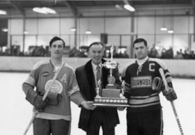
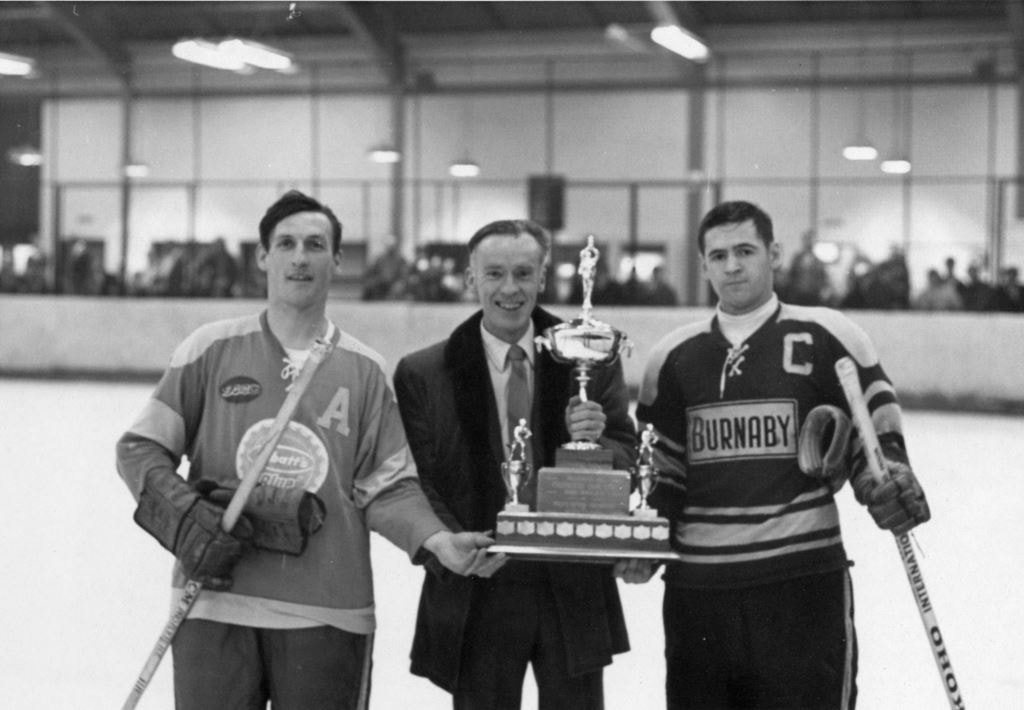
Burnaby Municipal Arena
https://search.heritageburnaby.ca/link/archivedescription58732
- Repository
- City of Burnaby Archives
- Date
- 1970
- Collection/Fonds
- Burnaby Historical Society fonds
- Description Level
- Item
- Physical Description
- 1 photograph
- Scope and Content
- Photograph of Burnaby Mayor Robert Prittie (standing in center) and two participants at the benefit hockey game between the Burnaby Detachment of the Royal Canadian Mounted Police and the Burnaby Fire Department.
- Repository
- City of Burnaby Archives
- Date
- 1970
- Collection/Fonds
- Burnaby Historical Society fonds
- Subseries
- Robert Prittie subseries
- Physical Description
- 1 photograph
- Description Level
- Item
- Record No.
- 368-003
- Access Restriction
- No restrictions
- Reproduction Restriction
- Reproduce for fair dealing purposes only
- Accession Number
- BHS1999-01
- Scope and Content
- Photograph of Burnaby Mayor Robert Prittie (standing in center) and two participants at the benefit hockey game between the Burnaby Detachment of the Royal Canadian Mounted Police and the Burnaby Fire Department.
- Names
- Prittie, Robert W. "Bob"
- Media Type
- Photograph
Images
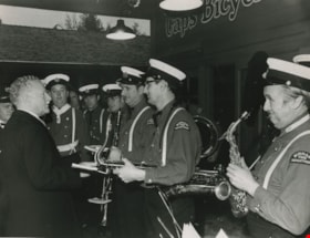
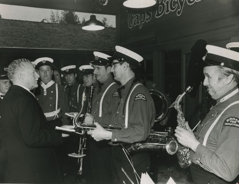
Governor General meeting the Burnaby Fire Department band
https://search.heritageburnaby.ca/link/archivedescription46303
- Repository
- City of Burnaby Archives
- Date
- November 19, 1971
- Collection/Fonds
- Columbian Newspaper collection
- Description Level
- Item
- Physical Description
- 1 photograph : b&w ; 18.5 x 24.5 cm
- Scope and Content
- Photograph of Governor General Roland Michener meeting the Burnaby Fire Department band at the opening of Heritage Village (later renamed Burnaby Village Museum).
- Repository
- City of Burnaby Archives
- Date
- November 19, 1971
- Collection/Fonds
- Columbian Newspaper collection
- Physical Description
- 1 photograph : b&w ; 18.5 x 24.5 cm
- Description Level
- Item
- Record No.
- 480-1191
- Access Restriction
- No restrictions
- Reproduction Restriction
- No restrictions
- Accession Number
- 2003-02
- Scope and Content
- Photograph of Governor General Roland Michener meeting the Burnaby Fire Department band at the opening of Heritage Village (later renamed Burnaby Village Museum).
- Subjects
- Organizations - Bands
- Occupations - Fire Fighters
- Musical Instruments
- Officials - Governor Generals
- Events - Openings
- Media Type
- Photograph
- Photographer
- King, Basil
- Notes
- Title based on contents of photograph
- Note on recto of photograph reads: "At Heritage Village - He meets Burnaby Fire Dept. BAND"
- Geographic Access
- Deer Lake Avenue
- Street Address
- 6501 Deer Lake Avenue
- Historic Neighbourhood
- Burnaby Lake (Historic Neighbourhood)
- Planning Study Area
- Morley-Buckingham Area
Images
![Henry H. Chapman, [1978], published February 28, 1978 thumbnail](/media/hpo/_Data/_Archives_Images/_Unrestricted/480/480-982.jpg?width=280)
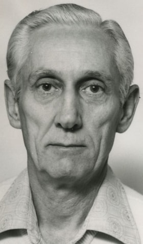
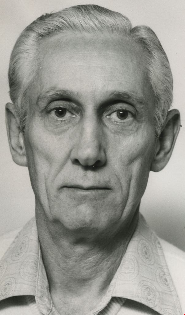
Henry H. Chapman
https://search.heritageburnaby.ca/link/archivedescription46094
- Repository
- City of Burnaby Archives
- Date
- [1978], published February 28, 1978
- Collection/Fonds
- Columbian Newspaper collection
- Description Level
- Item
- Physical Description
- 1 photograph : b&w ; 15.5 x 10 cm
- Scope and Content
- Photograph of Henry H. Chapman, chief fire prevention officer for the Buranby fire department in 1972.
- Repository
- City of Burnaby Archives
- Date
- [1978], published February 28, 1978
- Collection/Fonds
- Columbian Newspaper collection
- Physical Description
- 1 photograph : b&w ; 15.5 x 10 cm
- Description Level
- Item
- Record No.
- 480-982
- Access Restriction
- No restrictions
- Reproduction Restriction
- Reproduce for fair dealing purposes only
- Accession Number
- 2003-02
- Scope and Content
- Photograph of Henry H. Chapman, chief fire prevention officer for the Buranby fire department in 1972.
- Subjects
- Occupations - Fire Fighters
- Names
- Chapman, Henry H.
- Media Type
- Photograph
- Notes
- Title based on contents of photograph
Images
![Henry H. Chapman, [1978], published February 28, 1978 thumbnail](/media/hpo/_Data/_Archives_Images/_Unrestricted/480/480-982.jpg)
![Six Burnaby firemen, [197-?] thumbnail](/media/hpo/_Data/_BVM_Images/2000/200200100002.jpg?width=280)
Six Burnaby firemen
https://search.heritageburnaby.ca/link/museumdescription1604
- Repository
- Burnaby Village Museum
- Date
- [197-?]
- Collection/Fonds
- Burnaby Village Museum Photograph collection
- Description Level
- Item
- Physical Description
- 1 photograph : b&w ; 24.5 x 19 cm
- Scope and Content
- Photograph of six unidentified Burnaby firemen wearing Burnaby Fire Department helmets, standing in a hallway. Four of the firemen (in matching sweatshirts) are standing around a hose apparatus at the back, holding up an axe, hose nozzle, and a clock. The other two (one in a matching sweatshirt, th…
- Repository
- Burnaby Village Museum
- Collection/Fonds
- Burnaby Village Museum Photograph collection
- Description Level
- Item
- Physical Description
- 1 photograph : b&w ; 24.5 x 19 cm
- Scope and Content
- Photograph of six unidentified Burnaby firemen wearing Burnaby Fire Department helmets, standing in a hallway. Four of the firemen (in matching sweatshirts) are standing around a hose apparatus at the back, holding up an axe, hose nozzle, and a clock. The other two (one in a matching sweatshirt, the other in unifrom) are in front, holding a trophy towards the camera.
- Subjects
- Occupations - Fire Fighters
- Names
- Burnaby Fire Department
- Accession Code
- BV002.10.2
- Access Restriction
- Restricted access
- Reproduction Restriction
- May be restricted by third party rights
- Date
- [197-?]
- Media Type
- Photograph
- Scan Resolution
- 600
- Scan Date
- 09-Jun-09
- Scale
- 100
- Notes
- Title based on contents of photograph
Images
![Six Burnaby firemen, [197-?] thumbnail](/media/hpo/_Data/_BVM_Images/2000/200200100002.jpg)