Narrow Results By
Subject
- Advertising Medium - Signs and Signboards 2
- Buildings - Civic 5
- Buildings - Civic - Community Centres 2
- Buildings - Commercial - Restaurants 2
- Buildings - Recreational 24
- Buildings - Recreational - Bandstands 1
- Buildings - Recreational - Bowling Alleys 1
- Buildings - Recreational - Community Halls 8
- Buildings - Recreational - Gymnasiums 3
- Buildings - Recreational - Outdoor Swimming Pools 5
- Buildings - Recreational - Sports 13
- Buildings - Recreational - Stadiums 4
Person / Organization
- Bill Copeland Sports Centre 2
- Bonsor Recreation Complex 3
- Brown, Donald N. "Don" 1
- Burnaby Bulldogs 2
- Burnaby Fire Department 1
- Burnaby Lake Nature House 2
- Burnaby Lake Rowing Pavilion 1
- Burnaby Mountain Park 1
- Burnaby Winter Club 2
- Canlan Ice Sports Burnaby 8 Rinks 2
- Capitol Hill Community Hall 1
- Central Park 1
Burnaby Winter Club
https://search.heritageburnaby.ca/link/archivedescription93623
- Repository
- City of Burnaby Archives
- Date
- October 23, 1977
- Collection/Fonds
- Burnaby Public Library Contemporary Visual Archive Project
- Description Level
- Item
- Physical Description
- 1 photograph : b&w ; 12.5 x 17.5 cm
- Scope and Content
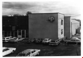
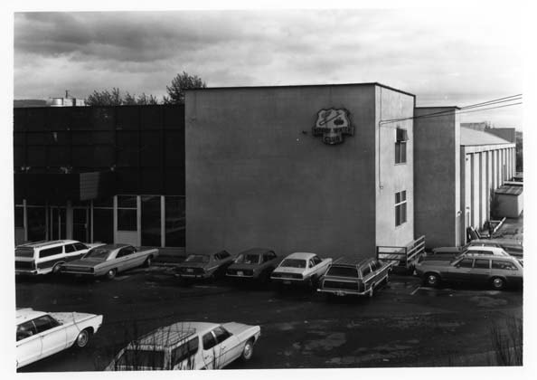
- Photograph of the parking lot and the exterior of the Burnaby Winter Club, located at Canada Way and Kensington Avenue. The photograph is taken facing north.
- Repository
- City of Burnaby Archives
- Date
- October 23, 1977
- Collection/Fonds
- Burnaby Public Library Contemporary Visual Archive Project
- Physical Description
- 1 photograph : b&w ; 12.5 x 17.5 cm
- Description Level
- Item
- Record No.
- 556-580
- Access Restriction
- No restrictions
- Reproduction Restriction
- Reproduce for fair dealing purposes only
- Accession Number
- 2017-57
- Scope and Content
- Photograph of the parking lot and the exterior of the Burnaby Winter Club, located at Canada Way and Kensington Avenue. The photograph is taken facing north.
- Subjects
- Buildings - Recreational
- Names
- Burnaby Winter Club
- Media Type
- Photograph
- Photographer
- Surridge, Jack
- Notes
- Title taken from project information form
- Accompanied by a project information form and 1 photograph (b&w negative ; 9.5 x 12.5 cm)
- BPL no. 27
- Street Address
- 4990 Canada Way
- Historic Neighbourhood
- Burnaby Lake (Historic Neighbourhood)
- Planning Study Area
- Douglas-Gilpin Area
Images

Capitol Hill Community Hall
https://search.heritageburnaby.ca/link/archivedescription93658
- Repository
- City of Burnaby Archives
- Date
- November 13, 1977
- Collection/Fonds
- Burnaby Public Library Contemporary Visual Archive Project
- Description Level
- Item
- Physical Description
- 1 photograph : b&w ; 12.5 x 17.5 cm
- Scope and Content
- Photograph of the exterior of the Capitol Hill Community Hall, located on Howard Avenue at the corner of Capitol Drive and Empire Drive. The photograph is taken from the parking lot, facing northeast. A sign advertising that night's event is on the roof of the hall.
- Repository
- City of Burnaby Archives
- Date
- November 13, 1977
- Collection/Fonds
- Burnaby Public Library Contemporary Visual Archive Project
- Physical Description
- 1 photograph : b&w ; 12.5 x 17.5 cm
- Description Level
- Item
- Record No.
- 556-615
- Access Restriction
- No restrictions
- Reproduction Restriction
- Reproduce for fair dealing purposes only
- Accession Number
- 2017-57
- Scope and Content
- Photograph of the exterior of the Capitol Hill Community Hall, located on Howard Avenue at the corner of Capitol Drive and Empire Drive. The photograph is taken from the parking lot, facing northeast. A sign advertising that night's event is on the roof of the hall.
- Media Type
- Photograph
- Photographer
- Chapman, Fred
- Notes
- Title taken from project information form
- Accompanied by a project information form and 1 photograph (b&w negative ; 9.5 x 12.5 cm)
- BPL no. 65
- Geographic Access
- Capitol Drive
- Howard Avenue
- Street Address
- 361 Howard Avenue
- Historic Neighbourhood
- Capitol Hill (Historic Neighbourhood)
- Planning Study Area
- Capitol Hill Area
Images


Centennial Pavilion
https://search.heritageburnaby.ca/link/archivedescription37407
- Repository
- City of Burnaby Archives
- Date
- 1970
- Collection/Fonds
- Burnaby Historical Society fonds
- Description Level
- Item
- Physical Description
- 1 photograph : col. postcard ; 9 x 14 cm
- Scope and Content
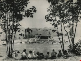
- Photographic postcard of the Centennial Pavilion located in Burnaby Mountain Park. The caption on the back of the postcard reads: "The Centennial Pavilion, located in Burnaby Mountain Park was built in 1958 to commemorate the centenary of the Province of British Columbia. Numerous view points on be…
- Repository
- City of Burnaby Archives
- Date
- 1970
- Collection/Fonds
- Burnaby Historical Society fonds
- Subseries
- Robert Prittie subseries
- Physical Description
- 1 photograph : col. postcard ; 9 x 14 cm
- Description Level
- Item
- Record No.
- 369-006
- Access Restriction
- No restrictions
- Reproduction Restriction
- Reproduce for fair dealing purposes only
- Accession Number
- BHS1999-01
- Scope and Content
- Photographic postcard of the Centennial Pavilion located in Burnaby Mountain Park. The caption on the back of the postcard reads: "The Centennial Pavilion, located in Burnaby Mountain Park was built in 1958 to commemorate the centenary of the Province of British Columbia. Numerous view points on beautifully landscaped grounds provide interesting panoramic views of the lower mainland."
- Media Type
- Photograph
- Photographer
- George Allen Aerial Photos Limited
- Notes
- Title based on caption
- Geographic Access
- Burnaby Mountain Conservation Area
- Centennial Way
- Street Address
- 100 Centennial Way
- Planning Study Area
- Burnaby Mountain Area
Images


Centennial Pavilion and Burnaby Mountain Park
https://search.heritageburnaby.ca/link/archivedescription37410
- Repository
- City of Burnaby Archives
- Date
- 1970
- Collection/Fonds
- Burnaby Historical Society fonds
- Description Level
- Item
- Physical Description
- 1 photograph : col. postcard ; 9 x 14 cm
- Scope and Content
- Photographic postcard of the rear portion of the Centennial Pavilion along with a view of some of the landscaping at Burnaby Mountain Park. The caption on the back of the photograph reads: "This park is situated on the western portion of Burnaby Mountain. Numerous view points throughout beautiful…
- Repository
- City of Burnaby Archives
- Date
- 1970
- Collection/Fonds
- Burnaby Historical Society fonds
- Subseries
- Robert Prittie subseries
- Physical Description
- 1 photograph : col. postcard ; 9 x 14 cm
- Description Level
- Item
- Record No.
- 369-009
- Access Restriction
- No restrictions
- Reproduction Restriction
- Reproduce for fair dealing purposes only
- Accession Number
- BHS1999-01
- Scope and Content
- Photographic postcard of the rear portion of the Centennial Pavilion along with a view of some of the landscaping at Burnaby Mountain Park. The caption on the back of the photograph reads: "This park is situated on the western portion of Burnaby Mountain. Numerous view points throughout beautifully landscaped grounds provide magnificent views of Burrard Inlet, Coast Range Mountains, City of Vancouver and surrounding Municipalities."
- Media Type
- Photograph
- Photographer
- George Allen Aerial Photos Limited
- Notes
- Title based on caption
- Geographic Access
- Burnaby Mountain Conservation Area
- Centennial Way
- Street Address
- 100 Centennial Way
- Planning Study Area
- Burnaby Mountain Area
Images

![Don Brown at Bonsor, [2002] thumbnail](/media/hpo/_Data/_Archives_Images/_Unrestricted/535/535-2778.jpg?width=280)
Don Brown at Bonsor
https://search.heritageburnaby.ca/link/archivedescription97403
- Repository
- City of Burnaby Archives
- Date
- [2002]
- Collection/Fonds
- Burnaby NewsLeader photograph collection
- Description Level
- Item
- Physical Description
- 1 photograph (tiff) : col.
- Scope and Content
- Photograph of Don Brown posing against a playing field's fence. The Bonsor Recreation Complex, where the South Burnaby Metro Club is based, and neighbouring office and apartment towers are visible in the background.
- Repository
- City of Burnaby Archives
- Date
- [2002]
- Collection/Fonds
- Burnaby NewsLeader photograph collection
- Physical Description
- 1 photograph (tiff) : col.
- Description Level
- Item
- Record No.
- 535-2778
- Access Restriction
- No restrictions
- Reproduction Restriction
- No restrictions
- Accession Number
- 2018-12
- Scope and Content
- Photograph of Don Brown posing against a playing field's fence. The Bonsor Recreation Complex, where the South Burnaby Metro Club is based, and neighbouring office and apartment towers are visible in the background.
- Media Type
- Photograph
- Photographer
- Bartel, Mario
- Notes
- Title based on caption
- Collected by editorial for use in a September 2002 issue of the Burnaby NewsLeader
- Caption from metadata: "Don Brown surveys all that has grown from the South Burnaby Men's Club's initial investment of $7500 to begin acquiring properties in the heart of Burnaby in 1965. He says the playing fields and Bonsor Recreation Centre, where the South Burnaby Metro Club is now based, are "an oasis" in the densely developed Metrotown area."
- Geographic Access
- Bonsor Avenue
- Street Address
- 6550 Bonsor Avenue
- Historic Neighbourhood
- Central Park (Historic Neighbourhood)
- Planning Study Area
- Marlborough Area
Images
![Don Brown at Bonsor, [2002] thumbnail](/media/hpo/_Data/_Archives_Images/_Unrestricted/535/535-2778.jpg)
![Dr. Andrew Blaber, [2005] thumbnail](/media/hpo/_Data/_Archives_Images/_Unrestricted/535/535-2186.jpg?width=280)
Dr. Andrew Blaber
https://search.heritageburnaby.ca/link/archivedescription96564
- Repository
- City of Burnaby Archives
- Date
- [2005]
- Collection/Fonds
- Burnaby NewsLeader photograph collection
- Description Level
- Item
- Physical Description
- 1 photograph (tiff) : col.
- Scope and Content
- Photograph of Dr. Andrew Blaber, who studies the physiology of freedivers at Simon Fraser University, posing by the edge of a swimming pool.
- Repository
- City of Burnaby Archives
- Date
- [2005]
- Collection/Fonds
- Burnaby NewsLeader photograph collection
- Physical Description
- 1 photograph (tiff) : col.
- Description Level
- Item
- Record No.
- 535-2186
- Access Restriction
- No restrictions
- Reproduction Restriction
- No restrictions
- Accession Number
- 2018-12
- Scope and Content
- Photograph of Dr. Andrew Blaber, who studies the physiology of freedivers at Simon Fraser University, posing by the edge of a swimming pool.
- Names
- Simon Fraser University
- Media Type
- Photograph
- Photographer
- Bartel, Mario
- Notes
- Title based on caption
- Collected by editorial for use in a March 2005 issue of the Burnaby NewsLeader
- Caption from metadata: "Dr. Andrew Blaber, of Simon Fraser University, is studying the physiology of freedivers, some of whom can hold their breath for up to eight minutes."
Images
![Dr. Andrew Blaber, [2005] thumbnail](/media/hpo/_Data/_Archives_Images/_Unrestricted/535/535-2186.jpg)
Event at the Centennial Pavilion
https://search.heritageburnaby.ca/link/archivedescription36102
- Repository
- City of Burnaby Archives
- Date
- June 29, 1973
- Collection/Fonds
- Burnaby Historical Society fonds
- Description Level
- Item
- Physical Description
- 1 photograph : b&w ; 14.5 x 19 cm
- Scope and Content
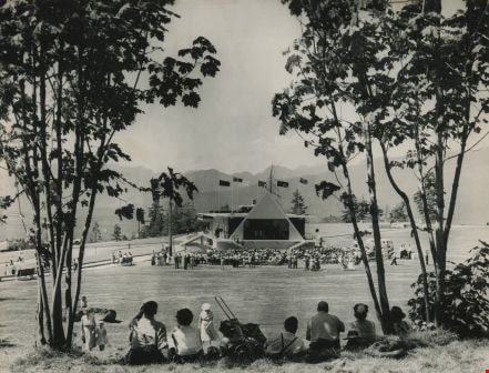
- Photograph of an event taking place at Burnaby Mountain's Centennial Pavilion.
- Repository
- City of Burnaby Archives
- Date
- June 29, 1973
- Collection/Fonds
- Burnaby Historical Society fonds
- Subseries
- Columbian Newspaper subseries
- Physical Description
- 1 photograph : b&w ; 14.5 x 19 cm
- Description Level
- Item
- Record No.
- 222-025
- Access Restriction
- Open access
- Reproduction Restriction
- Reproduce for fair dealing purposes only
- Accession Number
- BHS1989-19
- Scope and Content
- Photograph of an event taking place at Burnaby Mountain's Centennial Pavilion.
- Subjects
- Buildings - Recreational
- Media Type
- Photograph
- Photographer
- King, Basil
- Notes
- Title based on contents of photograph
- 2 b&w copy negatives accompanying
- Stamp on back of photograph reads: "Basil King Photo"
- Geographic Access
- Centennial Way
- Burnaby Mountain Conservation Area
- Street Address
- 100 Centennial Way
- Planning Study Area
- Burnaby Mountain Area
Images

Finnish Hall
https://search.heritageburnaby.ca/link/archivedescription79736
- Repository
- City of Burnaby Archives
- Date
- November 1, 1976
- Collection/Fonds
- Burnaby Public Library Contemporary Visual Archive Project
- Description Level
- Item
- Physical Description
- 1 photograph : b&w ; 11 x 16 cm mounted on cardboard
- Scope and Content
- Photograph shows the Finnish Hall at 3750 Hastings Street. Sign says it is available for weddings, dances, banquets and meetings.
- Repository
- City of Burnaby Archives
- Date
- November 1, 1976
- Collection/Fonds
- Burnaby Public Library Contemporary Visual Archive Project
- Physical Description
- 1 photograph : b&w ; 11 x 16 cm mounted on cardboard
- Description Level
- Item
- Record No.
- 556-409
- Access Restriction
- No restrictions
- Reproduction Restriction
- Reproduce for fair dealing purposes only
- Accession Number
- 2013-13
- Scope and Content
- Photograph shows the Finnish Hall at 3750 Hastings Street. Sign says it is available for weddings, dances, banquets and meetings.
- Names
- Finnish Hall
- Media Type
- Photograph
- Notes
- Scope note taken directly from BPL photograph description.
- 1 b&w copy negative : 10 x 12.5 cm accompanying
- Photographers identified by surnames only: Carr and Vardeman
- Geographic Access
- Hastings Street
- Street Address
- 3750 Hastings Street
- Historic Neighbourhood
- Vancouver Heights (Historic Neighbourhood)
- Planning Study Area
- Willingdon Heights Area
Images

![Fitness World fire, [2000] thumbnail](/media/hpo/_Data/_Archives_Images/_Unrestricted/535/535-2701.jpg?width=280)
Fitness World fire
https://search.heritageburnaby.ca/link/archivedescription97305
- Repository
- City of Burnaby Archives
- Date
- [2000]
- Collection/Fonds
- Burnaby NewsLeader photograph collection
- Description Level
- Item
- Physical Description
- 1 photograph (tiff) : col.
- Scope and Content
- Photograph of Bob Day, a gym patron, standing across from Fitness World on North Road, near Lougheed, during a fire. Burnaby Fire Department fire trucks are parked in front of the gym.
- Repository
- City of Burnaby Archives
- Date
- [2000]
- Collection/Fonds
- Burnaby NewsLeader photograph collection
- Physical Description
- 1 photograph (tiff) : col.
- Description Level
- Item
- Record No.
- 535-2701
- Access Restriction
- No restrictions
- Reproduction Restriction
- Reproduce for fair dealing purposes only
- Accession Number
- 2018-12
- Scope and Content
- Photograph of Bob Day, a gym patron, standing across from Fitness World on North Road, near Lougheed, during a fire. Burnaby Fire Department fire trucks are parked in front of the gym.
- Subjects
- Transportation - Fire Trucks
- Buildings - Recreational - Gymnasiums
- Natural Phenomena - Fires
- Names
- Burnaby Fire Department
- Media Type
- Photograph
- Photographer
- Bartel, Mario
- Notes
- Title based on caption
- Collected by editorial for use in a September 2000 issue of the Burnaby NewsLeader
- Caption from metadata: "Bob Day watches as Burnaby firefighters work to douse a minor blaze behind the sign at Fitness World on North Rd. Day was working out in the gym when staff told everyone to leave because of the fire."
- Geographic Access
- North Road
- Historic Neighbourhood
- Burquitlam (Historic Neighbourhood)
- Planning Study Area
- Cameron Area
Images
![Fitness World fire, [2000] thumbnail](/media/hpo/_Data/_Archives_Images/_Unrestricted/535/535-2701.jpg)
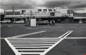
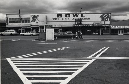
Hastings Bowl
https://search.heritageburnaby.ca/link/archivedescription79249
- Repository
- City of Burnaby Archives
- Date
- October, 1976
- Collection/Fonds
- Burnaby Public Library Contemporary Visual Archive Project
- Description Level
- Item
- Physical Description
- 1 photograph : b&w ; 11 x 16 cm mounted on cardboard
- Scope and Content
- Photograph shows Hastings Bowl at 4437 Hastings Street - a bowling alley owned by Jupiter Bowling Lanes Ltd. The alley is located abover several small shops and restaurants.
- Repository
- City of Burnaby Archives
- Date
- October, 1976
- Collection/Fonds
- Burnaby Public Library Contemporary Visual Archive Project
- Physical Description
- 1 photograph : b&w ; 11 x 16 cm mounted on cardboard
- Description Level
- Item
- Record No.
- 556-221
- Access Restriction
- No restrictions
- Reproduction Restriction
- Reproduce for fair dealing purposes only
- Accession Number
- 2013-13
- Scope and Content
- Photograph shows Hastings Bowl at 4437 Hastings Street - a bowling alley owned by Jupiter Bowling Lanes Ltd. The alley is located abover several small shops and restaurants.
- Names
- Hastings Bowl
- Media Type
- Photograph
- Photographer
- Cook, Alan
- Notes
- Scope note taken directly from BPL photograph description.
- 1 b&w copy negative : 10 x 12.5 cm accompanying
- Geographic Access
- Hastings Street
- Street Address
- 4437 Hastings Street
- Historic Neighbourhood
- Vancouver Heights (Historic Neighbourhood)
- Planning Study Area
- Burnaby Heights Area
Images
![Hockey forum at Burnaby 8 Rinks, [2000] thumbnail](/media/hpo/_Data/_Archives_Images/_Unrestricted/535/535-2107.jpg?width=280)
Hockey forum at Burnaby 8 Rinks
https://search.heritageburnaby.ca/link/archivedescription96483
- Repository
- City of Burnaby Archives
- Date
- [2000]
- Collection/Fonds
- Burnaby NewsLeader photograph collection
- Description Level
- Item
- Physical Description
- 1 photograph (tiff) : col.
- Scope and Content
- Photograph of a conference room filled with empty chairs for an unattended forum on violence in hockey at Burnaby Eight Rinks. In the background, a hockey rink is visible and Bernie Pascall and a reporter are speaking on the far side of the room.
- Repository
- City of Burnaby Archives
- Date
- [2000]
- Collection/Fonds
- Burnaby NewsLeader photograph collection
- Physical Description
- 1 photograph (tiff) : col.
- Description Level
- Item
- Record No.
- 535-2107
- Access Restriction
- No restrictions
- Reproduction Restriction
- No restrictions
- Accession Number
- 2018-12
- Scope and Content
- Photograph of a conference room filled with empty chairs for an unattended forum on violence in hockey at Burnaby Eight Rinks. In the background, a hockey rink is visible and Bernie Pascall and a reporter are speaking on the far side of the room.
- Media Type
- Photograph
- Photographer
- Bartel, Mario
- Notes
- Title based on caption
- Collected by editorial for use in a March 2000 issue of the Burnaby NewsLeader
- Caption from metadata: "Former broadcaster Bernie Pascall, who was to moderate a special forum on violence in hockey, at Burnaby Eight Rinks, speaks to a reporter, after nobody showed up for the open discussion, not even officials from Burnaby Minor Hockey."
- Geographic Access
- Sprott Street
- Street Address
- 6501 Sprott Street
- Historic Neighbourhood
- Burnaby Lake (Historic Neighbourhood)
- Planning Study Area
- Ardingley-Sprott Area
Images
![Hockey forum at Burnaby 8 Rinks, [2000] thumbnail](/media/hpo/_Data/_Archives_Images/_Unrestricted/535/535-2107.jpg)

Interview with Sev Morin by Rod Fowler April 4, 1990 - Track 10
https://search.heritageburnaby.ca/link/oralhistory546
- Repository
- City of Burnaby Archives
- Date Range
- 1950-1990
- Length
- 00:09:22
- Summary
- This portion of the interview is about Sev Morin’s views about Burnaby’s identity and the irrelevance of municipal boundary lines for many functions; his identification of Burnaby’s heritage, ecological and educational “gems”; and musings about the next development phases for Burnaby
- Repository
- City of Burnaby Archives
- Summary
- This portion of the interview is about Sev Morin’s views about Burnaby’s identity and the irrelevance of municipal boundary lines for many functions; his identification of Burnaby’s heritage, ecological and educational “gems”; and musings about the next development phases for Burnaby
- Date Range
- 1950-1990
- Photo Info
- Sev Morin (left) of Severin's in Burnaby (formerly the Gai Paree) hosting a gala New Year's celebration, 1979. Item no. 480-712
- Length
- 00:09:22
- Subjects
- Public Services - Municipal Services
- Planning
- Industries
- Geographic Features - Parks
- Buildings - Recreational
- Interviewer
- Fowler, Rod
- Interview Date
- April 4, 1990
- Scope and Content
- Recording is of an interview with Severin "Sev" Morin, conducted by Rod Fowler. Sev Morin was one of eleven participants interviewed as part of the SFU/Burnaby Centennial Committee's oral history series titled, "Voices of Burnaby". The interview is mainly about Sev Morin’s banquet hall, restaurant and night club business on Kingsway, originally named the “Gai Paree Supper Club” (1947-1976) and later “Severin’s” (1976-1985) and “Diego’s” (1985-1994), its function as a Burnaby landmark, and the entertainment and political people he met through his business. He also describes his many volunteer activities in Burnaby, including member of the SFU Senate, Rotary Club, Variety Club and Telethon, fund raising for Burnaby Hospital, and tourism related groups, and his political work for the federal Liberal party. He talks about his parents’ origins, the lives of his brothers Rudy and Rene, and the family’s involvement in establishing the “Gai Paree”. He also shares his views about the business and cultural development of Burnaby. To view “Narrow By” terms for each track expand this description and see “Notes”.
- Biographical Notes
- Severin “Sev” Rene Morin was born September 21, 1927, in Bonneville, Alberta, to Rene Pierre Morin (1878-1963) and Anne Marie (nee Lachiver) Morin (1886-1956). Mr. and Mrs. R. P. Morin and their son Rene Francois (1905-1954) immigrated to Edmonton, Alberta, from France in 1913, where Rene Pierre Morin worked for the C.N.R. and a second son Adolphe “Rudy” Ferdinand (1922-1969) was born, followed by their third son Severin. In 1943, after R.P. Morin retired, the family moved to Burnaby to a house on Sperling Avenue. Sometime earlier the two older Morin brothers found work in Trail at the smelter and developed musical careers. In 1946/47 the Morin family purchased property on Kingsway and built a banquet hall, the “Gai Paree Supper Club”. Sev and Rudy Morin managed the club and Rene F. Morin moved to Burnaby to join them with his band. The supper club, with its live music and dance floor, became a popular meeting place and wedding venue, eventually expanding into a restaurant and nightclub in the 1970s. The “Gai Paree” was renamed “Severin’s” in 1976 and “Diego’s” in 1985, closing finally in 1994. Sev Morin’s business life included three record stores which he owned with his friend Jack Cullen. Through these businesses Sev Morin was well known in the entertainment and hospitality industry. He and his restaurant also hosted political and social events that made the restaurant a community landmark. Sev Morin contributed many volunteer hours to community and charitable organizations, including an appointment to the SFU Senate, fundraising for the Burnaby Hospital, Director of the Variety Club and Rotary Club, and consultant for a variety of tourism related ventures. He also was active in the federal Liberal Party. Sev Morin and his wife Pauline married in 1950 and had three children. Sev Morin died at age 86 on March 28, 2014.
- Total Tracks
- 10
- Total Length
- 00:56:44
- Interviewee Name
- Morin, Severin "Sev"
- Interviewer Bio
- Rod Fowler returned to university as a mature student in the 1980s after working about twenty years in the field of economics and computerization in business in England, Europe and Western Canada. He graduated with a BA from SFU in both History and Sociology in 1987, his MA degree in Geography in 1989, and his PhD in Cultural Geography at SFU. He taught courses in Geography, Sociology, History and Canadian Studies at several Lower Mainland colleges, before becoming a full time member of the Geography Department at Kwantlen University College.
- Collection/Fonds
- SFU/Burnaby Centennial Committee fonds
- Transcript Available
- Transcript available
- Media Type
- Sound Recording
- Web Notes
- Interviews were digitized in 2015 allowing them to be accessible on Heritage Burnaby. The digitization project was initiated by the Community Heritage Commission with support from City of Burnaby Council.
Images

Audio Tracks
Track ten of interview with Sev Morin
Track ten of interview with Sev Morin
https://search.heritageburnaby.ca/media/hpo/_Data/_Archives_Oral_Histories/_Unrestricted/MSS187-021/MSS187-021_Track%2010.mp3![Keith Bruneau on the Velodrome, [2002] thumbnail](/media/hpo/_Data/_Archives_Images/_Unrestricted/535/535-2772.jpg?width=280)
Keith Bruneau on the Velodrome
https://search.heritageburnaby.ca/link/archivedescription97397
- Repository
- City of Burnaby Archives
- Date
- [2002]
- Collection/Fonds
- Burnaby NewsLeader photograph collection
- Description Level
- Item
- Physical Description
- 1 photograph (tiff) : col.
- Scope and Content
- Photograph of Keith Bruneau, a member of Canada's national cycling team, biking around the re-opened velodrome at the Harry Jerome Sports Centre.
- Repository
- City of Burnaby Archives
- Date
- [2002]
- Collection/Fonds
- Burnaby NewsLeader photograph collection
- Physical Description
- 1 photograph (tiff) : col.
- Description Level
- Item
- Record No.
- 535-2772
- Access Restriction
- No restrictions
- Reproduction Restriction
- No restrictions
- Accession Number
- 2018-12
- Scope and Content
- Photograph of Keith Bruneau, a member of Canada's national cycling team, biking around the re-opened velodrome at the Harry Jerome Sports Centre.
- Media Type
- Photograph
- Photographer
- Bartel, Mario
- Notes
- Title based on caption
- Collected by editorial for use in a September 2002 issue of the Burnaby NewsLeader
- Caption from metadata: "Keith Bruneau, a rider with Canada's national cycling team, takes a spin around the newly re-opened velodrome at the Harry Jerome Sports Centre."
- Geographic Access
- Barnet Road
- Street Address
- 7564 Barnet Road
- Historic Neighbourhood
- Barnet (Historic Neighbourhood)
- Planning Study Area
- Burnaby Mountain Area
Images
![Keith Bruneau on the Velodrome, [2002] thumbnail](/media/hpo/_Data/_Archives_Images/_Unrestricted/535/535-2772.jpg)

Kensington Arena
https://search.heritageburnaby.ca/link/archivedescription62671
- Repository
- City of Burnaby Archives
- Date
- August 27, 2009
- Collection/Fonds
- Community Heritage Commission Special Projects fonds
- Description Level
- Item
- Physical Description
- 1 photograph (tiff) : col. ; 600 ppi
- Scope and Content
- Photograph of Kensington Arena.
- Repository
- City of Burnaby Archives
- Date
- August 27, 2009
- Collection/Fonds
- Community Heritage Commission Special Projects fonds
- Physical Description
- 1 photograph (tiff) : col. ; 600 ppi
- Description Level
- Item
- Record No.
- 503-007
- Access Restriction
- No restrictions
- Reproduction Restriction
- No restrictions
- Accession Number
- 2009-10
- Scope and Content
- Photograph of Kensington Arena.
- Subjects
- Buildings - Recreational
- Names
- Kensington Arena
- Media Type
- Photograph
- Photographer
- Pasch, Rebecca
- Notes
- Title based on contents of photograph
- Geographic Access
- Curtis Street
- Street Address
- 6159 Curtis Street
- Historic Neighbourhood
- Capitol Hill (Historic Neighbourhood)
- Planning Study Area
- Parkcrest-Aubrey Area
Images


Kensington Park Rink
https://search.heritageburnaby.ca/link/archivedescription79741
- Repository
- City of Burnaby Archives
- Date
- September 7, 1976
- Collection/Fonds
- Burnaby Public Library Contemporary Visual Archive Project
- Description Level
- Item
- Physical Description
- 1 photograph : b&w ; 11 x 16 cm mounted on cardboard
- Scope and Content
- Photograph shows the Kensington Park Rink located at 6159 Curtis Street.
- Repository
- City of Burnaby Archives
- Date
- September 7, 1976
- Collection/Fonds
- Burnaby Public Library Contemporary Visual Archive Project
- Physical Description
- 1 photograph : b&w ; 11 x 16 cm mounted on cardboard
- Description Level
- Item
- Record No.
- 556-412
- Access Restriction
- No restrictions
- Reproduction Restriction
- Reproduce for fair dealing purposes only
- Accession Number
- 2013-13
- Scope and Content
- Photograph shows the Kensington Park Rink located at 6159 Curtis Street.
- Subjects
- Buildings - Recreational
- Names
- Kensington Arena
- Media Type
- Photograph
- Photographer
- Born, A. J.
- Notes
- Scope note taken directly from BPL photograph description.
- 1 b&w copy negative : 10 x 12.5 cm accompanying
- Geographic Access
- Curtis Street
- Street Address
- 6159 Curtis Street
- Planning Study Area
- Parkcrest-Aubrey Area
Images


Kingsway
https://search.heritageburnaby.ca/link/archivedescription35874
- Repository
- City of Burnaby Archives
- Date
- 1900 (date of original), copied 1986
- Collection/Fonds
- Burnaby Historical Society fonds
- Description Level
- Item
- Physical Description
- 1 photograph : b&w ; 12.7 x 17.8 cm print
- Scope and Content
- Photograph of Kingsway (then Westminster Road), looking east from Boundary Road near Central Park. Included in the photograph; Central Park Presbyterian Church, Masonic Hall and Reid's Hall.
- Repository
- City of Burnaby Archives
- Date
- 1900 (date of original), copied 1986
- Collection/Fonds
- Burnaby Historical Society fonds
- Subseries
- Pioneer Tales subseries
- Physical Description
- 1 photograph : b&w ; 12.7 x 17.8 cm print
- Description Level
- Item
- Record No.
- 204-733
- Access Restriction
- No restrictions
- Reproduction Restriction
- No known restrictions
- Accession Number
- BHS1988-03
- Scope and Content
- Photograph of Kingsway (then Westminster Road), looking east from Boundary Road near Central Park. Included in the photograph; Central Park Presbyterian Church, Masonic Hall and Reid's Hall.
- Subjects
- Buildings - Recreational - Community Halls
- Buildings - Religious - Churches
- Geographic Features - Roads
- Media Type
- Photograph
- Notes
- Title based on contents of photograph
- Geographic Access
- Westminster Avenue
- Kingsway
- Street Address
- 3777 Kingsway
- Historic Neighbourhood
- Central Park (Historic Neighbourhood)
- Planning Study Area
- Garden Village Area
Images

![Len McNeely in the Burnaby Winter Club arena, [2004] thumbnail](/media/hpo/_Data/_Archives_Images/_Unrestricted/535/535-2064.jpg?width=280)
Len McNeely in the Burnaby Winter Club arena
https://search.heritageburnaby.ca/link/archivedescription96394
- Repository
- City of Burnaby Archives
- Date
- [2004]
- Collection/Fonds
- Burnaby NewsLeader photograph collection
- Description Level
- Item
- Physical Description
- 1 photograph (tiff) : col.
- Scope and Content
- Photograph of Len McNeely, the general manager of the Burnaby Winter Club, in the main ice arena at the Club. McNeely wears a hockey jersey and is leaning against a hockey net; championship flags hang around the perimeter of the ice.
- Repository
- City of Burnaby Archives
- Date
- [2004]
- Collection/Fonds
- Burnaby NewsLeader photograph collection
- Physical Description
- 1 photograph (tiff) : col.
- Description Level
- Item
- Record No.
- 535-2064
- Access Restriction
- No restrictions
- Reproduction Restriction
- No restrictions
- Accession Number
- 2018-12
- Scope and Content
- Photograph of Len McNeely, the general manager of the Burnaby Winter Club, in the main ice arena at the Club. McNeely wears a hockey jersey and is leaning against a hockey net; championship flags hang around the perimeter of the ice.
- Media Type
- Photograph
- Photographer
- Bartel, Mario
- Notes
- Title based on caption
- Collected by editorial for use in a March 2004 issue of the Burnaby NewsLeader
- Caption from metadata: "Len McNeely, the general manager of the Burnaby Winter Club, admires the championship banners that surround the ice surface at the club's main arena. And with three team heading to Provincials, there may soon be more added."
- Geographic Access
- Canada Way
- Street Address
- 4990 Canada Way
- Historic Neighbourhood
- Burnaby Lake (Historic Neighbourhood)
- Planning Study Area
- Douglas-Gilpin Area
Images
![Len McNeely in the Burnaby Winter Club arena, [2004] thumbnail](/media/hpo/_Data/_Archives_Images/_Unrestricted/535/535-2064.jpg)

Lochdale Community Hall
https://search.heritageburnaby.ca/link/archivedescription93672
- Repository
- City of Burnaby Archives
- Date
- January 18, 1978
- Collection/Fonds
- Burnaby Public Library Contemporary Visual Archive Project
- Description Level
- Item
- Physical Description
- 1 photograph : b&w ; 12.5 x 17.5 cm
- Scope and Content
- Photograph of the front exterior of Lochdale Community Hall, located near Sperling and Hastings Street and built in 1925. Cars are parked in front of and beside the hall. The photograph is taken from across the street, facing east.
- Repository
- City of Burnaby Archives
- Date
- January 18, 1978
- Collection/Fonds
- Burnaby Public Library Contemporary Visual Archive Project
- Physical Description
- 1 photograph : b&w ; 12.5 x 17.5 cm
- Description Level
- Item
- Record No.
- 556-629
- Access Restriction
- No restrictions
- Reproduction Restriction
- Reproduce for fair dealing purposes only
- Accession Number
- 2017-57
- Scope and Content
- Photograph of the front exterior of Lochdale Community Hall, located near Sperling and Hastings Street and built in 1925. Cars are parked in front of and beside the hall. The photograph is taken from across the street, facing east.
- Names
- Lochdale Community Hall
- Media Type
- Photograph
- Photographer
- Surridge, Jack
- Notes
- Title taken from project information form
- Accompanied by a project information form and 1 photograph (b&w negative ; 9.5 x 12.5 cm)
- BPL no. 78
- Geographic Access
- Hastings Street
- Sperling Avenue
- Street Address
- 490 Sperling Avenue
- Historic Neighbourhood
- Lochdale (Historic Neighbourhood)
- Planning Study Area
- Lochdale Area
Images

![MacPherson Pool, [2000] thumbnail](/media/hpo/_Data/_Archives_Images/_Unrestricted/535/535-2621.jpg?width=280)
MacPherson Pool
https://search.heritageburnaby.ca/link/archivedescription97093
- Repository
- City of Burnaby Archives
- Date
- [2000]
- Collection/Fonds
- Burnaby NewsLeader photograph collection
- Description Level
- Item
- Physical Description
- 1 photograph (tiff) : col.
- Scope and Content
- Photograph of Berwin Hong, a lifeguard at MacPherson Pool, testing the pool's water before the pool's opening for the summer.
- Repository
- City of Burnaby Archives
- Date
- [2000]
- Collection/Fonds
- Burnaby NewsLeader photograph collection
- Physical Description
- 1 photograph (tiff) : col.
- Description Level
- Item
- Record No.
- 535-2621
- Access Restriction
- No restrictions
- Reproduction Restriction
- No restrictions
- Accession Number
- 2018-12
- Scope and Content
- Photograph of Berwin Hong, a lifeguard at MacPherson Pool, testing the pool's water before the pool's opening for the summer.
- Media Type
- Photograph
- Photographer
- Bartel, Mario
- Notes
- Title based on caption
- Collected by editorial for use in an June 2000 issue of the Burnaby NewsLeader
- Caption from metadata: "Berwin Hong, a lifeguard at MacPherson Pool, tests the water in preperation for the pool's scheduled opening on Saturday. All five of Burnaby's outdoor pools are set to open for the summer on the weekend."
- Geographic Access
- Rumble Street
- McPherson Park
- Street Address
- 5485 Rumble Street
- Historic Neighbourhood
- Alta Vista (Historic Neighbourhood)
- Planning Study Area
- Clinton-Glenwood Area
Images
![MacPherson Pool, [2000] thumbnail](/media/hpo/_Data/_Archives_Images/_Unrestricted/535/535-2621.jpg)
![March for Hunger at Swangard Stadium, [2000] thumbnail](/media/hpo/_Data/_Archives_Images/_Unrestricted/535/535-2098.jpg?width=280)
March for Hunger at Swangard Stadium
https://search.heritageburnaby.ca/link/archivedescription96437
- Repository
- City of Burnaby Archives
- Date
- [2000]
- Collection/Fonds
- Burnaby NewsLeader photograph collection
- Description Level
- Item
- Physical Description
- 1 photograph (tiff) : col.
- Scope and Content
- Photograph of Scouts and Guides from Burnaby and Vancouver walking around the track at Swangard Stadium as part of their eighth annual March for Hunger. Some of the children wear their uniforms and some people carry flags.
- Repository
- City of Burnaby Archives
- Date
- [2000]
- Collection/Fonds
- Burnaby NewsLeader photograph collection
- Physical Description
- 1 photograph (tiff) : col.
- Description Level
- Item
- Record No.
- 535-2098
- Access Restriction
- No restrictions
- Reproduction Restriction
- No restrictions
- Accession Number
- 2018-12
- Scope and Content
- Photograph of Scouts and Guides from Burnaby and Vancouver walking around the track at Swangard Stadium as part of their eighth annual March for Hunger. Some of the children wear their uniforms and some people carry flags.
- Subjects
- Organizations - Boys' Societies and Clubs
- Organizations - Girls' Societies and Clubs
- Events - Fundraising
- Buildings - Recreational - Stadiums
- Names
- Swangard Stadium
- Media Type
- Photograph
- Photographer
- Bartel, Mario
- Notes
- Title based on caption
- Collected by editorial for use in a March 2000 issue of the Burnaby NewsLeader
- Caption from metadata: "Scouts and Guides from Burnaby and Vancouver hiked around Swangard Stadium and Central Park in their eighth annual March for Hunger, to raise donations for the Food Bank."
- Geographic Access
- Central Park
- Imperial Street
- Street Address
- 3883 Imperial Street
- Historic Neighbourhood
- Central Park (Historic Neighbourhood)
- Planning Study Area
- Maywood Area
Images
![March for Hunger at Swangard Stadium, [2000] thumbnail](/media/hpo/_Data/_Archives_Images/_Unrestricted/535/535-2098.jpg)