More like 'Deer Lake'
Narrow Results By
Decade
- 2020s 119
- 2010s 118
- 2000s 662
- 1990s 641
- 1980s 487
- 1970s 946
- 1960s
- 1950s 544
- 1940s 596
- 1930s 608
- 1920s 650
- 1910s 604
- 1900s
- 1890s 36
- 1880s 70
- 1870s 5
- 1860s 3
- 1850s 1
- 1840s 1
- 1830s 1
- 1820s 1
- 1810s 1
- 1800s 1
- 1790s 1
- 1780s 1
- 1770s 1
- 1760s 1
- 1750s 1
- 1740s 1
- 1730s 1
- 1720s 1
- 1710s 1
- 1700s 1
- 1690s 1
- 1680s 1
- 1670s 1
- 1660s 1
- 1650s 1
- 1640s 1
- 1630s 1
- 1620s 1
- 1610s 1
- 1600s 1

Duncan & Margaret McGregor Estate 'Glen-Lyon' Mansion
https://search.heritageburnaby.ca/link/landmark518
- Repository
- Burnaby Heritage Planning
- Description
- Overlooking the rich farmland of the Fraser River floodplain, 'Glen-Lyon' is an Edwardian era rural estate, with a tall, two and one-half storey plus basement wood-frame mansion, set in a pastoral and formal landscape with an associated barn and early log pond, located near a ravine and forested ar…
- Associated Dates
- 1902
- Formal Recognition
- Heritage Designation, Community Heritage Register
- Street View URL
- Google Maps Street View
- Repository
- Burnaby Heritage Planning
- Geographic Access
- Marine Drive
- Associated Dates
- 1902
- Formal Recognition
- Heritage Designation, Community Heritage Register
- Enactment Type
- Bylaw No. 12183
- Enactment Date
- 11/12/2006
- Description
- Overlooking the rich farmland of the Fraser River floodplain, 'Glen-Lyon' is an Edwardian era rural estate, with a tall, two and one-half storey plus basement wood-frame mansion, set in a pastoral and formal landscape with an associated barn and early log pond, located near a ravine and forested area adjacent to Marine Drive in South Burnaby.
- Heritage Value
- ‘Glen-Lyon’ is valued as an excellent example of a privately-owned Edwardian era country estate built at the turn of the nineteenth century. The property retains significant heritage features including the Edwardian era mansion with rustic Arts and Crafts features, and elements of a working agricultural landscape. The property was originally the Royal City Mills logging camp, and in 1900 was purchased by Duncan Campbell McGregor (1853-1929) and Margaret Jane McGregor (1875-1960), who named their estate ‘Glen-Lyon’ after Duncan McGregor’s birthplace in Perthshire, Scotland. The McGregors were active in municipal affairs and social activities, and played a significant role in the early development of Burnaby. Duncan McGregor served as a city councillor from 1909 to 1912 and was elected reeve of Burnaby in 1913. Margaret McGregor was instrumental in the formation and fundraising activities of the Victoria Order of Nurses in Burnaby. Additionally, the site is historically significant for its association with early social welfare and correctional reform. The estate was sold in 1926 to an inter-denominational religious organization called the Home of the Friendless, which used it as their B.C. headquarters. The organization was charged with several cases of abuse and neglect in 1937, after which a Royal Commission was formed that led to new legislation to regulate and license all private welfare institutions. 'Glen-Lyon' was sold to the provincial government, and was dedicated in 1939 by the Lt.-Gov. E.W. Hamber for use as the New Haven Borstal Home for Boys and Youthful Offenders (later renamed the New Haven Correction Centre). The Borstal movement originated in England in the late nineteenth century, as an alternative to sending young offenders and runaways to prisons by providing reformatories that focused on discipline and vocational skill. This site’s role as the first North American institution devoted to the Borstal School philosophy was historic, and influenced corrections programs across Canada. The site retains significant features from its development in 1939 as the Borstal School, including a large gambrel-roofed barn designed by Chief Provincial Architect Henry Whittaker of the Department of Public Works that is the only remaining structure of its kind in Burnaby. Between 1941 and 1945 the mansion housed the Provincial School for the Deaf and Blind when the Borstal School was closed temporarily as a war measure during the Second World War.
- Defining Elements
- Key elements that define the heritage character of 'Glen-Lyon' Mansion include its: - location on a sloping site with expansive southern exposure, adjacent to Marine Drive - residential form, scale and massing of the house as exemplified by its two and one-half storey height, above-ground basement and rectangular plan - Arts and Crafts elements of the house such as its stone foundation, multi-gabled roof line with steep central hipped roof, symmetrical cross-gables, side shed dormers, bellcast upper walls sheathed in cedar shingles and lower walls sheathed in narrow clapboard - original exterior features of the house such as the full width front verandah with square columns, central staircase on the southern elevation, original doors and stained glass windows; and the irregular fenestration such as double-hung 1-over-1 wooden-sash windows, bay windows, and projecting windows in the gable ends - original interior features of the house such as the U-shaped main stair designed around two symmetrically placed Ionic columns, and interior trim on the main floor including boxed beams and fireplaces - gambrel-roofed barn with roof vent with finial, sliding hay loft and access doors, small multi-pane windows, and lapped wooden siding - associated landscape features such as the original garden plantings with some exotic and many native specimen trees; the original log pond and its concrete Marine Drive causeway and culvert; rockeries and a rose garden
- Historic Neighbourhood
- Fraser Arm (Historic Neighbourhood)
- Planning Study Area
- Big Bend Area
- Architect
- Henry Whittaker
- Function
- Primary Historic--Estate
- Community
- Burnaby
- Cadastral Identifier
- 003-004-661
- Boundaries
- 'Glen-Lyon' is comprised of a single residential lot located at 4250 Marine Drive, Burnaby.
- Area
- 230873.18
- Contributing Resource
- Building
- Ownership
- Private
- Names
- McGregor, Duncan C. (1853-1929)
- Whittaker, Henry
- Home of the Friendless
- Borstal School
- New Haven Correction Centre
- Subjects
- Buildings - Heritage
- Buildings - Residential - Houses
- Buildings - Public - Detention Facilities
- Buildings - Residential
- Street Address
- 4250 Marine Drive
- Street View URL
- Google Maps Street View
Images


H.T. Ceperley Estate 'Fairacres' Steam Plant Building
https://search.heritageburnaby.ca/link/landmark528
- Repository
- Burnaby Heritage Planning
- Description
- Designed in the British Arts and Crafts style, the ‘Fairacres’ Steam Plant Buiding is a single-storey wood frame building with a gabled roof that originally housed the apparatus for climate control in the greenhouses, formerly located to its north. The original rubble stone walls that formed the fo…
- Associated Dates
- 1908
- Formal Recognition
- Heritage Designation, Community Heritage Register
- Repository
- Burnaby Heritage Planning
- Geographic Access
- Deer Lake Avenue
- Associated Dates
- 1908
- Formal Recognition
- Heritage Designation, Community Heritage Register
- Enactment Type
- Bylaw No. 9807
- Enactment Date
- 23/11/1992
- Description
- Designed in the British Arts and Crafts style, the ‘Fairacres’ Steam Plant Buiding is a single-storey wood frame building with a gabled roof that originally housed the apparatus for climate control in the greenhouses, formerly located to its north. The original rubble stone walls that formed the foundation for the greenhouses stand adjacent. The Steam Plant Building stands as a pendant to the Root House, which is to the north of the former greenhouses.
- Heritage Value
- The outbuildings at 'Fairacres' are a rare surviving architecturally-designed ensemble of agricultural structures that exist in complementary harmony with the main estate house. Architect Robert Mackay Fripp (1858-1917), an outspoken advocate of Arts and Crafts design, was retained by the Ceperleys to design several original outbuildings on their estate. The Ceperleys operated 'Fairacres' with staff, a farm manager and workers, including Chinese, to grow produce for themselves and for sale at local markets. The Steam Plant Building illustrates the market gardening activity of the area around Deer Lake and its importance to the Ceperley family, which valued a year-round supply of fresh fruit and vegetables for the kitchen and flowers for the house. It also illustrates the cultural and aesthetic values of the Ceperleys in retaining an architect to design a functional outbuilding using an accepted and contemporary architectural style. Built in 1908, the Steam Plant Building was significantly altered in the 1960s and restored to its original design in 2000.
- Defining Elements
- Key elements that define the heritage character of the ‘Fairacres’ Steam Plant Building include its: - overall spatial arrangement of the Steam Plant Building in relation to the former greenhouses and the Root House - side gable roof with cedar shingle cladding. - tall brick chimney indicitive of the building's original function. - distinctive Arts and Crafts architectural features such as the shingle wall cladding with decorative shingling under window sills, deep eaves, and pebble-dashed concrete foundation walls - six-paned wooden-sash casement windows - simple functional interior features - rubble stone walls that formed the foundation for the greenhouses
- Locality
- Deer Lake Park
- Historic Neighbourhood
- Burnaby Lake (Historic Neighbourhood)
- Planning Study Area
- Douglas-Gilpin Area
- Architect
- Robert Mackay Fripp
- Function
- Primary Historic--Outbuilding
- Community
- Burnaby
- Cadastral Identifier
- P.I.D. No. 004-493-311 Legal Description: Block 3 Except: Part subdivided by Plan 26865, District Lot 79, Group 1, New Westminster District, Plan 536
- Boundaries
- ‘Fairacres’ is comprised of a single municipally-owned property located at 6344 Deer Lake Avenue, Burnaby.
- Area
- 17,065.00
- Contributing Resource
- Building
- Landscape Feature
- Ownership
- Public (local)
- Other Collection
- Burnaby Historical Society, Community Archives: Ceperley Photograph Album
- Documentation
- Heritage Site Files: PC77000 20. City of Burnaby Planning and Building Department, 4949 Canada Way, Burnaby, B.C., V5G 1M2
- Street Address
- 6344 Deer Lake Avenue
Images


H.T. Ceperley Estate 'Fairacres' Root House
https://search.heritageburnaby.ca/link/landmark527
- Repository
- Burnaby Heritage Planning
- Description
- The ‘Fairacres’ Root House is a long, low one-storey masonry building, measuring 4.6 metres by 9.1 metres, with massively buttressed concrete walls and foundations. Built into sloping ground adjacent to the location of the former greenhouses, the surviving orchard and the kitchen entrance of the ma…
- Associated Dates
- 1908
- Formal Recognition
- Heritage Designation, Community Heritage Register
- Repository
- Burnaby Heritage Planning
- Geographic Access
- Deer Lake Avenue
- Associated Dates
- 1908
- Formal Recognition
- Heritage Designation, Community Heritage Register
- Enactment Type
- Bylaw No. 9807
- Enactment Date
- 23/11/1992
- Description
- The ‘Fairacres’ Root House is a long, low one-storey masonry building, measuring 4.6 metres by 9.1 metres, with massively buttressed concrete walls and foundations. Built into sloping ground adjacent to the location of the former greenhouses, the surviving orchard and the kitchen entrance of the main house, 'Fairacres,' this functional structure was used as a frost-free store for fruit and vegetables for the family's use.
- Heritage Value
- The outbuildings at 'Fairacres' are a rare surviving architecturally-designed ensemble of agricultural structures that exist in complementary harmony with the main estate house. Architect Robert Mackay Fripp (1858-1917), an outspoken advocate of Arts and Crafts design, was retained by the Ceperleys to design several original outbuildings on their estate. The Root House is important as a rare surviving, and exceptionally large, example of this building type in the Vancouver region. Unusual in the fact that an architect designed a building of such modest aspirations, it is also remarkable in its method of construction. The use of concrete as a structural material is one of the earliest in the region and extraordinary for its use on such a modest vernacular outbuilding; root cellars were typically built of loose stone. Built in 1908, the Root House was significantly altered in the 1960s and restored to its original design in 2000. The building is significant as an indicator of the market gardening activity in the area around Deer Lake and of the country-house self-sufficiency practiced by the Ceperley family. The Root House illustrates the cultural, aesthetic, and lifestyle values of the Ceperleys in constructing such a large building for storing their own produce.
- Defining Elements
- The outbuildings at 'Fairacres' are a rare surviving architecturally-designed ensemble of agricultural structures that exist in complementary harmony with the main estate house. Architect Robert Mackay Fripp (1858-1917), an outspoken advocate of Arts and Crafts design, was retained by the Ceperleys to design several original outbuildings on their estate. The Root House is important as a rare surviving, and exceptionally large, example of this building type in the Vancouver region. Unusual in the fact that an architect designed a building of such modest aspirations, it is also remarkable in its method of construction. The use of concrete as a structural material is one of the earliest in the region and extraordinary for its use on such a modest vernacular outbuilding; root cellars were typically built of loose stone. Built in 1908, the Root House was significantly altered in the 1960s and restored to its original design in 2000. The building is significant as an indicator of the market gardening activity in the area around Deer Lake and of the country-house self-sufficiency practiced by the Ceperley family. The Root House illustrates the cultural, aesthetic, and lifestyle values of the Ceperleys in constructing such a large building for storing their own produce.
- Locality
- Deer Lake Park
- Historic Neighbourhood
- Burnaby Lake (Historic Neighbourhood)
- Planning Study Area
- Douglas-Gilpin Area
- Architect
- Robert Mackay Fripp
- Function
- Primary Historic--Outbuilding
- Secondary Historic--Food Storage
- Community
- Burnaby
- Cadastral Identifier
- P.I.D. No. 004-493-311 Legal Description: Block 3 Except: Part subdivided by Plan 26865, District Lot 79, Group 1, New Westminster District, Plan 536
- Boundaries
- ‘Fairacres’ is comprised of a single municipally-owned property located at 6344 Deer Lake Avenue, Burnaby.
- Area
- 17,065.00
- Contributing Resource
- Building
- Landscape Feature
- Ownership
- Public (local)
- Other Collection
- Burnaby Historical Society, Community Archives: Ceperley Photograph Album
- Documentation
- Heritage Site Files: PC77000 20. City of Burnaby Planning and Building Department, 4949 Canada Way, Burnaby, B.C., V5G 1M2
- Street Address
- 6344 Deer Lake Avenue
Images


H.T. Ceperley Estate 'Fairacres' Greenhouse Foundation Wall
https://search.heritageburnaby.ca/link/landmark862
- Repository
- Burnaby Heritage Planning
- Description
- The original rubble stone walls that formed the foundation for a greenhouses adjacent to the Steam Plant Building provided heat to several greenhouses on the estate propoerty. The Root House, which is to the north of the Greenhouse Foundation Wall, provided storage for the farm operation.
- Associated Dates
- 1908
- Formal Recognition
- Heritage Designation, Community Heritage Register
- Repository
- Burnaby Heritage Planning
- Geographic Access
- Deer Lake Avenue
- Associated Dates
- 1908
- Formal Recognition
- Heritage Designation, Community Heritage Register
- Enactment Type
- Bylaw No. 140665
- Enactment Date
- 23/11/1992
- Description
- The original rubble stone walls that formed the foundation for a greenhouses adjacent to the Steam Plant Building provided heat to several greenhouses on the estate propoerty. The Root House, which is to the north of the Greenhouse Foundation Wall, provided storage for the farm operation.
- Heritage Value
- The outbuildings at 'Fairacres' are a rare surviving architecturally-designed ensemble of agricultural structures that exist in complementary harmony with the main estate house. Architect Robert Mackay Fripp (1858-1917), an outspoken advocate of Arts and Crafts design, was retained by the Ceperleys to design several original outbuildings on their estate, which was designed as a country estate with a working farm that included over 10 acres of productive berry and vegetable fields, with a large kitchen garden, a root house to store food, an orchard, and greenhouses heated by steam. The agricultural potential of the Deer Lake area made it one of the first parts of the municipality to attract settlement. In 1909, the Ceperleys built three large greenhouses heated by an adjacent steam plant (Fairacres Steam Plant). The greenhouses featured granite foundation walls, including this one which remains intact. The Ceperleys employed a large staff to manage the estate's agricultural production, including Chinese farm labourers. Produce was grown for use at the estate, and for sale at local markets. Agricultural use of the estate continued when a Catholic order of Benedictine monks purchased the estate as part of the Priory of St. Joseph and the Seminary of Christ the King, and continued to farm the land until 1953.
- Defining Elements
- Key elements that define the heritage character of the ‘Fairacres’ Steam Plant Building include its: - overall spatial arrangement of the Greenhouse Foundation Wall in relation to the Steam Plant Building and the Root House - original rubble stone walls reflecting the Arts and Crafts design aesthetic of the estate buildings.
- Locality
- Deer Lake Park
- Historic Neighbourhood
- Burnaby Lake (Historic Neighbourhood)
- Planning Study Area
- Douglas-Gilpin Area
- Architect
- Robert Mackay Fripp
- Function
- Primary Historic--Outbuilding
- Community
- Burnaby
- Cadastral Identifier
- P.I.D. No. 004-493-311 Legal Description: Block 3 Except: Part subdivided by Plan 26865, District Lot 79, Group 1, New Westminster District, Plan 536
- Boundaries
- ‘Fairacres’ is comprised of a single municipally-owned property located at 6344 Deer Lake Avenue, Burnaby.
- Area
- 17,065.00
- Contributing Resource
- Landscape Feature
- Remains
- Ownership
- Public (local)
- Other Collection
- Burnaby Historical Society, Community Archives: Ceperley Photograph Album
- Documentation
- Heritage Site Files: PC77000 20. City of Burnaby Planning and Building Department, 4949 Canada Way, Burnaby, B.C., V5G 1M2
- Street Address
- 6344 Deer Lake Avenue
Images


Arrow Neon Sign
https://search.heritageburnaby.ca/link/landmark861
- Repository
- Burnaby Heritage Planning
- Description
- Commercial building.
- Associated Dates
- 1961
- Other Names
- Lost in the 50's Drive-in
- Street View URL
- Google Maps Street View
- Repository
- Burnaby Heritage Planning
- Other Names
- Lost in the 50's Drive-in
- Geographic Access
- Edmonds Street
- Associated Dates
- 1961
- Description
- Commercial building.
- Heritage Value
- The Arrow Neon Sign was built in 1961 by the Neonette Sign Company of New Westminster when this property was opened as the Tomahawk Drive-in Restaurant. The restaurant was later known as Lindy's Burger and in 1990, the business was renamed Lost in the 50's Drive-in. It stands 20-foot tall and is composed of a large double-sided hollow steel panel serpentine arrow mounted on a pole supporting a lexan sign panel measuring approximately 8 feet wide by 4 feet tall. The sign was designed with three illuminated features: a round lamp at the top of the pole, a double-sided rectangular fluorescent sign panel box, and two double-sided rows of orange neon arrows that follow the large serpentine arrow. The Arrow Neon Sign remains as a rare surviving example of neon sign art in the city and is the only historic neon sign in South Burnaby. The sign has gained prominence over the years as it has been associated with this small iconic drive-in which has also been utilized as a set for film production. Additionally, the drive-in has played a prominent role in the Edmonds community as a popular setting for recent "Show and Shine" participants to park their classic cars.
- Locality
- Edmonds
- Historic Neighbourhood
- East Burnaby (Historic Neighbourhood)
- Planning Study Area
- Lakeview-Mayfield Area
- Builder
- Neonette Sign Company
- Community
- Burnaby
- Contributing Resource
- Structure
- Ownership
- Public (local)
- Street Address
- 7741 Edmonds Street
- Street View URL
- Google Maps Street View
Images


Deer Lake from the Baldwin House
https://search.heritageburnaby.ca/link/archivedescription37350
- Repository
- City of Burnaby Archives
- Date
- 1966
- Collection/Fonds
- Burnaby Historical Society fonds
- Description Level
- Item
- Physical Description
- 1 photograph : b&w ; 19.5 x 21.5 cm
- Scope and Content
- Photograph of Deer Lake from the corner of the Baldwin house. Two women can be seen standing on the deck at the upper level of the home, but neither are identified.
- Repository
- City of Burnaby Archives
- Date
- 1966
- Collection/Fonds
- Burnaby Historical Society fonds
- Subseries
- Baldwin family subseries
- Physical Description
- 1 photograph : b&w ; 19.5 x 21.5 cm
- Description Level
- Item
- Record No.
- 357-005
- Access Restriction
- No restrictions
- Reproduction Restriction
- Reproduce for fair dealing purposes only
- Accession Number
- BHS1998-03
- Scope and Content
- Photograph of Deer Lake from the corner of the Baldwin house. Two women can be seen standing on the deck at the upper level of the home, but neither are identified.
- Subjects
- Buildings - Heritage
- Buildings - Residential - Houses
- Geographic Features - Lakes and Ponds
- Media Type
- Photograph
- Photographer
- King, Basil
- Notes
- Title based on contents of photograph
- Geographic Access
- Deer Lake Drive
- Deer Lake
- Street Address
- 6543 Deer Lake Drive
- Historic Neighbourhood
- Burnaby Lake (Historic Neighbourhood)
- Planning Study Area
- Morley-Buckingham Area
Images

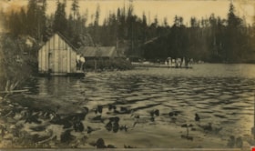
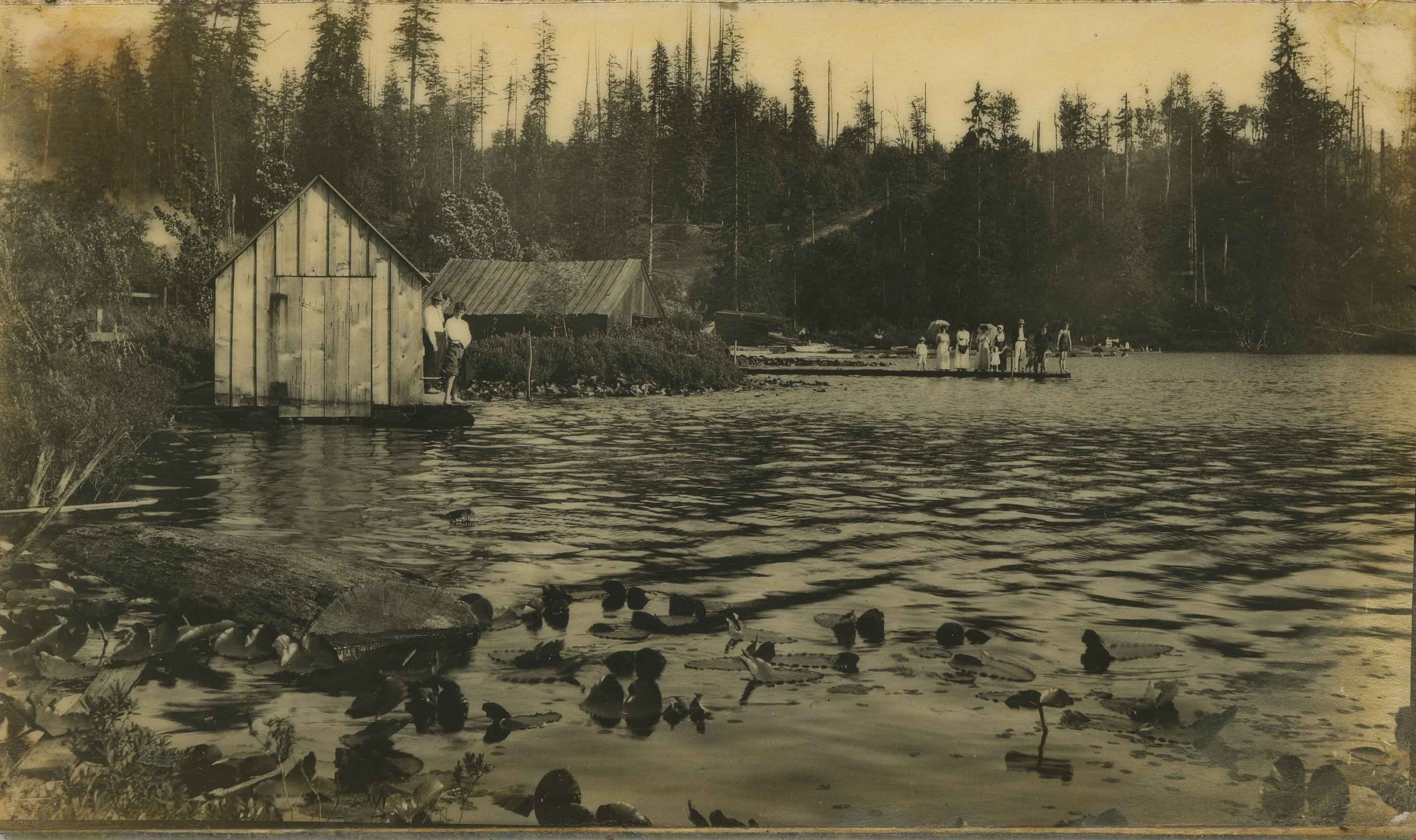
Deer Lake
https://search.heritageburnaby.ca/link/archivedescription34278
- Repository
- City of Burnaby Archives
- Date
- 1904
- Collection/Fonds
- Burnaby Historical Society fonds
- Description Level
- Item
- Physical Description
- 1 photograph : b&w ; 8.1 x 13.8 cm
- Scope and Content
- Photograph of Deer Lake, looking southeast. Three men are standing by a boatshed on the left, a group of people (men, women and children) are standing on a dock, and other people can be seen on the beach in the background.
- Repository
- City of Burnaby Archives
- Date
- 1904
- Collection/Fonds
- Burnaby Historical Society fonds
- Subseries
- Photographs subseries
- Physical Description
- 1 photograph : b&w ; 8.1 x 13.8 cm
- Description Level
- Item
- Record No.
- 014-001
- Access Restriction
- No restrictions
- Reproduction Restriction
- No known restrictions
- Accession Number
- BHS2007-04
- Scope and Content
- Photograph of Deer Lake, looking southeast. Three men are standing by a boatshed on the left, a group of people (men, women and children) are standing on a dock, and other people can be seen on the beach in the background.
- Media Type
- Photograph
- Notes
- Title based on contents of photograph
- Geographic Access
- Deer Lake
- Deer Lake Avenue
- Historic Neighbourhood
- Burnaby Lake (Historic Neighbourhood)
- Planning Study Area
- Morley-Buckingham Area
Images
![Blythe Eagles outside his home, [between 1955 and 1960] (date of original), copied 1996 thumbnail](/media/Hpo/_Data/_Archives_Images/_Unrestricted/205/245-002.jpg?width=280)
Blythe Eagles outside his home
https://search.heritageburnaby.ca/link/archivedescription51540
- Repository
- City of Burnaby Archives
- Date
- [between 1955 and 1960] (date of original), copied 1996
- Collection/Fonds
- Burnaby Historical Society fonds
- Description Level
- Item
- Physical Description
- 1 photograph : b&w copy negative ; 4 x 5.5 cm
- Scope and Content
- Photograph of Blythe Eagles standing in front of the Eagles' estate at Deer Lake.
- Repository
- City of Burnaby Archives
- Date
- [between 1955 and 1960] (date of original), copied 1996
- Collection/Fonds
- Burnaby Historical Society fonds
- Subseries
- Eagles family subseries
- Physical Description
- 1 photograph : b&w copy negative ; 4 x 5.5 cm
- Description Level
- Item
- Record No.
- 245-002
- Access Restriction
- No restrictions
- Reproduction Restriction
- Reproduce for fair dealing purposes only
- Accession Number
- BHS1990-11
- Scope and Content
- Photograph of Blythe Eagles standing in front of the Eagles' estate at Deer Lake.
- Names
- Eagles, Dr. Blythe
- Media Type
- Photograph
- Notes
- Title based on contents of photograph
- 1 b&w ; 12.7 x 17.7 cm print accompanying
- Geographic Access
- Sperling Avenue
- Street Address
- 5655 Sperling Avenue
- Historic Neighbourhood
- Burnaby Lake (Historic Neighbourhood)
- Planning Study Area
- Morley-Buckingham Area
Images
![Blythe Eagles outside his home, [between 1955 and 1960] (date of original), copied 1996 thumbnail](/media/Hpo/_Data/_Archives_Images/_Unrestricted/205/245-002.jpg)

Burnaby Lake Show / originals
https://search.heritageburnaby.ca/link/archivedescription91683
- Repository
- City of Burnaby Archives
- Date
- 1962-1995
- Collection/Fonds
- Doreen Lawson fonds
- Description Level
- File
- Physical Description
- 71 photographs : col. slides ; 35 mm
- Scope and Content
- File consists of photographs compiled by Doreen Lawson for a slideshow presentation about Burnaby Lake. Slideshow primarily depicts the wildlife and foliage of Burnaby Lake, including: the American coot, green-winged teal, bufflehead, heron, american bittern, barn swallow, barn owl, painted turtle,…
- Repository
- City of Burnaby Archives
- Date
- 1962-1995
- Collection/Fonds
- Doreen Lawson fonds
- Physical Description
- 71 photographs : col. slides ; 35 mm
- Description Level
- File
- Record No.
- 618-001
- Access Restriction
- No restrictions
- Reproduction Restriction
- May be restricted by third party rights
- Accession Number
- 2015-15
- Scope and Content
- File consists of photographs compiled by Doreen Lawson for a slideshow presentation about Burnaby Lake. Slideshow primarily depicts the wildlife and foliage of Burnaby Lake, including: the American coot, green-winged teal, bufflehead, heron, american bittern, barn swallow, barn owl, painted turtle, muskrat, Canadian goose, beaver, wood duck, bullrushes, yellow and white waterlilies, yellow iris, and loosestrife. Also included in the slideshow are photographs of the BC Wildlife rescue and fisherman working in the Brunette River.
- Subjects
- Geographic Features - Lakes and Ponds
- Animals - Birds
- Animals
- Geographic Features - Forests
- Media Type
- Photograph
- Photographer
- Lawson, Doreen A.
- Chapman, Fred
- Notes
- Transcribed title
- Title transcribed from sheets slides
- Photographs contents are identified on many of the slide cases within the file.
- Historic Neighbourhood
- Burnaby Lake (Historic Neighbourhood)
- Planning Study Area
- Burnaby Lake Area
Images

![Douglas Road, Burnaby, [1908] thumbnail](/media/hpo/_Data/_Archives_Images/_Unrestricted/371/449-009.jpg?width=280)
Douglas Road, Burnaby
https://search.heritageburnaby.ca/link/archivedescription38514
- Repository
- City of Burnaby Archives
- Date
- [1908]
- Collection/Fonds
- Burnaby Historical Society fonds
- Description Level
- Item
- Physical Description
- 1 photograph : sepia postcard ; 8.8 x 14 cm
- Scope and Content
- Photographic postcard taken looking northwest along Douglas Road (now Canada Way) near Stanley Street. Two unidentified people are standing next to a wooden fence running alongside the road (above Lubbock's Creek) and a number of houses (including the Sprott house) are visible in the background. To…
- Repository
- City of Burnaby Archives
- Date
- [1908]
- Collection/Fonds
- Burnaby Historical Society fonds
- Subseries
- Photographs subseries
- Physical Description
- 1 photograph : sepia postcard ; 8.8 x 14 cm
- Description Level
- Item
- Record No.
- 449-009
- Access Restriction
- No restrictions
- Reproduction Restriction
- No known restrictions
- Accession Number
- BHS2007-04
- Scope and Content
- Photographic postcard taken looking northwest along Douglas Road (now Canada Way) near Stanley Street. Two unidentified people are standing next to a wooden fence running alongside the road (above Lubbock's Creek) and a number of houses (including the Sprott house) are visible in the background. To the right is Burnaby Lake. Stamped at the top of the postcard is "Douglas Road, Burnaby / New Westminster BC."
- Subjects
- Geographic Features - Lakes and Ponds
- Documentary Artifacts - Postcards
- Geographic Features - Roads
- Media Type
- Photograph
- Geographic Access
- Douglas Road
- Stanley Street
- Canada Way
- Deer Lake
- Historic Neighbourhood
- Burnaby Lake (Historic Neighbourhood)
- Planning Study Area
- Lakeview-Mayfield Area
Images
![Douglas Road, Burnaby, [1908] thumbnail](/media/hpo/_Data/_Archives_Images/_Unrestricted/371/449-009.jpg)
![Tony Fabian relaxing at a picnic table, [1970]. Item no. 549-026. thumbnail](/media/hpo/_Data/_Archives_Images/_Unrestricted/540/549-026.jpg?width=280)
Interview with Tony Fabian by Eric Damer October 10, 2012 - Track 1
https://search.heritageburnaby.ca/link/oralhistory322
- Repository
- City of Burnaby Archives
- Date Range
- 1957-1965
- Length
- 0:09:56
- Summary
- This portion of the recording pertains to Tony Fabian's memories of first coming to Burnaby and establishing a vegetable garden. He talks about his interest in conservation from an early age.
- Repository
- City of Burnaby Archives
- Summary
- This portion of the recording pertains to Tony Fabian's memories of first coming to Burnaby and establishing a vegetable garden. He talks about his interest in conservation from an early age.
- Date Range
- 1957-1965
- Photo Info
- Tony Fabian relaxing at a picnic table, [1970]. Item no. 549-026.
- Length
- 0:09:56
- Interviewer
- Damer, Eric
- Interview Date
- October 10, 2012
- Scope and Content
- Recording is an interview with Tony Fabian conducted by Burnaby Village Museum employee Eric Damer, October 10, 2012. Major theme discussed: environmental conservation practices in Burnaby.
- Biographical Notes
- Tony Fabian was born and raised in rural Saskatchewan in 1934. He and his wife moved to Burnaby in 1957, where he worked for the telephone company and raised a family. Tony has been an advocate for preservation of parklands and watercourses, helping to protect Burnaby and Deer Lake Parks and to create the Burnaby Fraser Foreshore and Barnet Marine Parks in the early nineteen-seventies, serving as a member of Burnaby’s Parks and Recreation Commission. Tony Fabian was presented with the 2008 City of Burnaby Environment Award for Community Stewardship.
- Total Tracks
- 5
- Total Length
- 0:47:48
- Interviewee Name
- Fabian, Tony
- Interview Location
- Burnaby Village Museum
- Interviewer Bio
- Eric Damer is a lifelong British Columbian born in Victoria, raised in Kamloops, and currently residing in Burnaby. After studying philosophy at the University of Victoria, he became interested in the educational forces that had shaped his own life. He completed master’s and doctoral degrees in educational studies at the University of British Columbia with a particular interest in the history of adult and higher education in the province. In 2012, Eric worked for the City of Burnaby as a field researcher and writer, conducting interviews for the City Archives and Museum Oral History Program.
- Collection/Fonds
- Community Heritage Commission Special Projects fonds
- Transcript Available
- None
- Media Type
- Sound Recording
Images
![Tony Fabian relaxing at a picnic table, [1970]. Item no. 549-026. thumbnail](/media/hpo/_Data/_Archives_Images/_Unrestricted/540/549-026.jpg)
Audio Tracks
Track one of recording of interview with Tony Fabian
Track one of recording of interview with Tony Fabian
https://search.heritageburnaby.ca/media/hpo/_Data/_Archives_Oral_Histories/_Unrestricted/MSS171-009/MSS171-009_Track_1.mp3
Interview with Tony Fabian by Eric Damer October 10, 2012 - Track 2
https://search.heritageburnaby.ca/link/oralhistory323
- Repository
- City of Burnaby Archives
- Date Range
- 1957-1973
- Length
- 0:08:50
- Summary
- This portion of the recording pertains to Tony Fabian's memories of conservation practices in Burnaby, focusing on the lakes and ravines, including Burnaby Lake.
- Repository
- City of Burnaby Archives
- Summary
- This portion of the recording pertains to Tony Fabian's memories of conservation practices in Burnaby, focusing on the lakes and ravines, including Burnaby Lake.
- Date Range
- 1957-1973
- Photo Info
- Tony Fabian relaxing at a picnic table, [1970]. Item no. 549-026.
- Length
- 0:08:50
- Interviewer
- Damer, Eric
- Interview Date
- October 10, 2012
- Scope and Content
- Recording is an interview with Tony Fabian conducted by Burnaby Village Museum employee Eric Damer, October 10, 2012. Major theme discussed: environmental conservation practices in Burnaby.
- Biographical Notes
- Tony Fabian was born and raised in rural Saskatchewan in 1934. He and his wife moved to Burnaby in 1957, where he worked for the telephone company and raised a family. Tony has been an advocate for preservation of parklands and watercourses, helping to protect Burnaby and Deer Lake Parks and to create the Burnaby Fraser Foreshore and Barnet Marine Parks in the early nineteen-seventies, serving as a member of Burnaby’s Parks and Recreation Commission. Tony Fabian was presented with the 2008 City of Burnaby Environment Award for Community Stewardship.
- Total Tracks
- 5
- Total Length
- 0:47:48
- Interviewee Name
- Fabian, Tony
- Interview Location
- Burnaby Village Museum
- Interviewer Bio
- Eric Damer is a lifelong British Columbian born in Victoria, raised in Kamloops, and currently residing in Burnaby. After studying philosophy at the University of Victoria, he became interested in the educational forces that had shaped his own life. He completed master’s and doctoral degrees in educational studies at the University of British Columbia with a particular interest in the history of adult and higher education in the province. In 2012, Eric worked for the City of Burnaby as a field researcher and writer, conducting interviews for the City Archives and Museum Oral History Program.
- Collection/Fonds
- Community Heritage Commission Special Projects fonds
- Transcript Available
- None
- Media Type
- Sound Recording
Images
Audio Tracks
Track two of recording of interview with Tony Fabian
Track two of recording of interview with Tony Fabian
https://search.heritageburnaby.ca/media/hpo/_Data/_Archives_Oral_Histories/_Unrestricted/MSS171-009/MSS171-009_Track_2.mp3![4042 Yale Street, [1961 or 1962] (date of original), copied 1991 thumbnail](/media/hpo/_Data/_Archives_Images/_Unrestricted/370/370-214.jpg?width=280)
4042 Yale Street
https://search.heritageburnaby.ca/link/archivedescription37626
- Repository
- City of Burnaby Archives
- Date
- [1961 or 1962] (date of original), copied 1991
- Collection/Fonds
- Burnaby Historical Society fonds
- Description Level
- Item
- Physical Description
- 1 photograph : b&w ; 3.9 x 3.9 cm print on contact sheet 20.2 x 25.3 cm
- Scope and Content
- Photograph from above 4042 Yale Street looking northeast. Burrard Inlet and the northshore mountains are visible in the background. The photograph was taken during the winter of 1961 to 1962, and there is snow.
- Repository
- City of Burnaby Archives
- Date
- [1961 or 1962] (date of original), copied 1991
- Collection/Fonds
- Burnaby Historical Society fonds
- Subseries
- Burnaby Image Bank subseries
- Physical Description
- 1 photograph : b&w ; 3.9 x 3.9 cm print on contact sheet 20.2 x 25.3 cm
- Description Level
- Item
- Record No.
- 370-214
- Access Restriction
- No restrictions
- Reproduction Restriction
- No restrictions
- Accession Number
- BHS1999-03
- Scope and Content
- Photograph from above 4042 Yale Street looking northeast. Burrard Inlet and the northshore mountains are visible in the background. The photograph was taken during the winter of 1961 to 1962, and there is snow.
- Subjects
- Buildings - Residential - Houses
- Geographic Features - Inlets
- Geographic Features - Mountains
- Media Type
- Photograph
- Notes
- Title based on contents of photograph
- 1 b&w copy negative accompanying
- Geographic Access
- Yale Street
- Street Address
- 4042 Yale Street
- Historic Neighbourhood
- Vancouver Heights (Historic Neighbourhood)
- Planning Study Area
- Burnaby Heights Area
Images
![4042 Yale Street, [1961 or 1962] (date of original), copied 1991 thumbnail](/media/hpo/_Data/_Archives_Images/_Unrestricted/370/370-214.jpg)
![Aerial view of Burnaby Lake, October 20, 1961 (date of original), copied [1985] thumbnail](/media/hpo/_Data/_BVM_Images/1985/1985_0457_0002_001.jpg?width=280)
Aerial view of Burnaby Lake
https://search.heritageburnaby.ca/link/museumdescription10583
- Repository
- Burnaby Village Museum
- Date
- October 20, 1961 (date of original), copied [1985]
- Collection/Fonds
- Burnaby Village Museum Photograph collection
- Description Level
- Item
- Physical Description
- 1 photograph : b&w copy negative ; 10 x 12 cm
- Scope and Content
- Photograph of aerial view of Burnaby Lake and construction for water main crossing at Piper Avenue.
- Repository
- Burnaby Village Museum
- Collection/Fonds
- Burnaby Village Museum Photograph collection
- Description Level
- Item
- Physical Description
- 1 photograph : b&w copy negative ; 10 x 12 cm
- Scope and Content
- Photograph of aerial view of Burnaby Lake and construction for water main crossing at Piper Avenue.
- Accession Code
- BV985.457.2
- Access Restriction
- No restrictions
- Reproduction Restriction
- May be restricted by third party rights
- Date
- October 20, 1961 (date of original), copied [1985]
- Media Type
- Photograph
- Historic Neighbourhood
- Burnaby Lake (Historic Neighbourhood)
- Planning Study Area
- Burnaby Lake Area
- Scan Resolution
- 1200
- Scan Date
- 2022-06-07
- Photographer
- George Allen Aerial Photos Limited
- Notes
- Title based on contents of photograph
Images
![Aerial view of Burnaby Lake, October 20, 1961 (date of original), copied [1985] thumbnail](/media/hpo/_Data/_BVM_Images/1985/1985_0457_0002_001.jpg)
![Annie Hill and Maude Woodward, [1905] thumbnail](/media/hpo/_Data/_Archives_Images/_Unrestricted/477/477-124.jpg?width=280)
Annie Hill and Maude Woodward
https://search.heritageburnaby.ca/link/archivedescription38805
- Repository
- City of Burnaby Archives
- Date
- [1905]
- Collection/Fonds
- Peers Family and Hill Family fonds
- Description Level
- Item
- Physical Description
- 1 photograph : b&w ; 5.5 x 8 cm on page 11.5 x 14 cm (pasted in album)
- Scope and Content
- Photograph of Annie Hill paddling a boat with Maude Woodward reclining behind her, most likely at Deer Lake.
- Repository
- City of Burnaby Archives
- Date
- [1905]
- Collection/Fonds
- Peers Family and Hill Family fonds
- Physical Description
- 1 photograph : b&w ; 5.5 x 8 cm on page 11.5 x 14 cm (pasted in album)
- Description Level
- Item
- Record No.
- 477-124
- Access Restriction
- No restrictions
- Reproduction Restriction
- No known restrictions
- Accession Number
- 2007-12
- Scope and Content
- Photograph of Annie Hill paddling a boat with Maude Woodward reclining behind her, most likely at Deer Lake.
- Media Type
- Photograph
- Notes
- Title based on contents of photograph
- Geographic Access
- Deer Lake
- Historic Neighbourhood
- Burnaby Lake (Historic Neighbourhood)
Images
![Annie Hill and Maude Woodward, [1905] thumbnail](/media/hpo/_Data/_Archives_Images/_Unrestricted/477/477-124.jpg)
![Annie, Kitty and Maude at Deer Lake, [1905] thumbnail](/media/hpo/_Data/_Archives_Images/_Unrestricted/477/477-125.jpg?width=280)
Annie, Kitty and Maude at Deer Lake
https://search.heritageburnaby.ca/link/archivedescription38806
- Repository
- City of Burnaby Archives
- Date
- [1905]
- Collection/Fonds
- Peers Family and Hill Family fonds
- Description Level
- Item
- Physical Description
- 1 photograph : b&w ; 5.5 x 8 cm on page 11.5 x 14 cm (pasted in album)
- Scope and Content
- Photograph of Annie Hill (standing, with back to the camera), Maude Woodward (seated) and Kitty Hill (with paddle) standing on the dock in their bathing costumes, most likely at Deer Lake.
- Repository
- City of Burnaby Archives
- Date
- [1905]
- Collection/Fonds
- Peers Family and Hill Family fonds
- Physical Description
- 1 photograph : b&w ; 5.5 x 8 cm on page 11.5 x 14 cm (pasted in album)
- Description Level
- Item
- Record No.
- 477-125
- Access Restriction
- No restrictions
- Reproduction Restriction
- No known restrictions
- Accession Number
- 2007-12
- Scope and Content
- Photograph of Annie Hill (standing, with back to the camera), Maude Woodward (seated) and Kitty Hill (with paddle) standing on the dock in their bathing costumes, most likely at Deer Lake.
- Media Type
- Photograph
- Notes
- Title based on contents of photograph
- Geographic Access
- Deer Lake
- Historic Neighbourhood
- Burnaby Lake (Historic Neighbourhood)
Images
![Annie, Kitty and Maude at Deer Lake, [1905] thumbnail](/media/hpo/_Data/_Archives_Images/_Unrestricted/477/477-125.jpg)
![Boating on the lake, [1905] thumbnail](/media/hpo/_Data/_Archives_Images/_Unrestricted/477/477-143.jpg?width=280)
Boating on the lake
https://search.heritageburnaby.ca/link/archivedescription38824
- Repository
- City of Burnaby Archives
- Date
- [1905]
- Collection/Fonds
- Peers Family and Hill Family fonds
- Description Level
- Item
- Physical Description
- 1 photograph : sepia ; 5 x 7.5 cm on page 11.5 x 14 cm (pasted in album)
- Scope and Content
- Photograph of a group of people boating on a lake. The group is unidentified.
- Repository
- City of Burnaby Archives
- Date
- [1905]
- Collection/Fonds
- Peers Family and Hill Family fonds
- Physical Description
- 1 photograph : sepia ; 5 x 7.5 cm on page 11.5 x 14 cm (pasted in album)
- Description Level
- Item
- Record No.
- 477-143
- Access Restriction
- No restrictions
- Reproduction Restriction
- No known restrictions
- Accession Number
- 2007-12
- Scope and Content
- Photograph of a group of people boating on a lake. The group is unidentified.
- Media Type
- Photograph
- Notes
- Title based on contents of photograph
Images
![Boating on the lake, [1905] thumbnail](/media/hpo/_Data/_Archives_Images/_Unrestricted/477/477-143.jpg)
![B. Patterson with his dog on Burnaby Lake, [190-] (date of original), copied 1977 thumbnail](/media/hpo/_Data/_BVM_Images/1977/1977_0099_0001_001.jpg?width=280)
B. Patterson with his dog on Burnaby Lake
https://search.heritageburnaby.ca/link/museumdescription559
- Repository
- Burnaby Village Museum
- Date
- [190-] (date of original), copied 1977
- Collection/Fonds
- Burnaby Village Museum Photograph collection
- Description Level
- Item
- Physical Description
- 1 photograph : b&w ; 20.2 x 25.2 cm print
- Scope and Content
- Photograph of four men and a dog named Hector standing on a frozen lake, looking at a dead frozen deer. Some of them seem to be wearing skates. According to a catalogue record from 1977, the original print had written explanation stating: "Bruce and Bill [Patterson] with some friends found a wild…
- Repository
- Burnaby Village Museum
- Collection/Fonds
- Burnaby Village Museum Photograph collection
- Description Level
- Item
- Physical Description
- 1 photograph : b&w ; 20.2 x 25.2 cm print
- Scope and Content
- Photograph of four men and a dog named Hector standing on a frozen lake, looking at a dead frozen deer. Some of them seem to be wearing skates. According to a catalogue record from 1977, the original print had written explanation stating: "Bruce and Bill [Patterson] with some friends found a wild deer frozen in the ice on Burnaby Lake about three miles from house. Not often do we get a winter like this." An annotation on the back of the photo reads: "Burnaby Lake / B. Paterson standing beside dog. / No date."
- Subjects
- Animals - Deer
- Animals - Dogs
- Events - Deaths
- Geographic Features - Lakes and Ponds
- Natural Phenomena - Snow
- Geographic Access
- Burnaby Lake
- Accession Code
- HV977.99.1
- Access Restriction
- No restrictions
- Reproduction Restriction
- May be restricted by third party rights
- Date
- [190-] (date of original), copied 1977
- Media Type
- Photograph
- Planning Study Area
- Burnaby Lake Area
- Scan Resolution
- 600
- Scan Date
- 2023-07-11
- Notes
- Title based on contents of photograph
Images
![B. Patterson with his dog on Burnaby Lake, [190-] (date of original), copied 1977 thumbnail](/media/hpo/_Data/_BVM_Images/1977/1977_0099_0001_001.jpg)
![Burnaby Lake, [between 1890 and 1909] thumbnail](/media/hpo/_Data/_BVM_Images/2000/200300610003.jpg?width=280)
Burnaby Lake
https://search.heritageburnaby.ca/link/museumdescription1677
- Repository
- Burnaby Village Museum
- Date
- [between 1890 and 1909]
- Collection/Fonds
- Burnaby Village Museum Photograph collection
- Description Level
- Item
- Physical Description
- 1 photograph : sepia ; 5 x 7.5 cm, mounted on card 10 x 12.5 cm
- Scope and Content
- Photograph of Burnaby Lake.
- Repository
- Burnaby Village Museum
- Collection/Fonds
- Burnaby Village Museum Photograph collection
- Description Level
- Item
- Physical Description
- 1 photograph : sepia ; 5 x 7.5 cm, mounted on card 10 x 12.5 cm
- Scope and Content
- Photograph of Burnaby Lake.
- Geographic Access
- Burnaby Lake
- Accession Code
- BV003.61.3
- Access Restriction
- No restrictions
- Date
- [between 1890 and 1909]
- Media Type
- Photograph
- Historic Neighbourhood
- Burnaby Lake (Historic Neighbourhood)
- Planning Study Area
- Burnaby Lake Area
- Scan Resolution
- 600
- Scan Date
- 09-Jun-09
- Scale
- 100
- Notes
- Title based on contents of photograph
- Note in pencil on verso of photograph reads: "Near Burnaby Lake/ Burnaby, B.C."
Images
![Burnaby Lake, [between 1890 and 1909] thumbnail](/media/hpo/_Data/_BVM_Images/2000/200300610003.jpg)
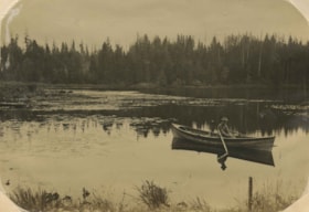
Claude Hill on Deer Lake
https://search.heritageburnaby.ca/link/archivedescription39521
- Repository
- City of Burnaby Archives
- Date
- 1906
- Collection/Fonds
- Peers Family and Hill Family fonds
- Description Level
- Item
- Physical Description
- 1 photograph : b&w ; 11.3 x 16.3 cm on page 21.5 x 28 cm (pasted in album)
- Scope and Content
- Photograph of Claude Hill sitting in a rowboat on Deer Lake. The photograph was taken looking southwest across Deer Lake.
- Repository
- City of Burnaby Archives
- Date
- 1906
- Collection/Fonds
- Peers Family and Hill Family fonds
- Physical Description
- 1 photograph : b&w ; 11.3 x 16.3 cm on page 21.5 x 28 cm (pasted in album)
- Description Level
- Item
- Record No.
- 477-840
- Access Restriction
- No restrictions
- Reproduction Restriction
- No known restrictions
- Accession Number
- 2007-12
- Scope and Content
- Photograph of Claude Hill sitting in a rowboat on Deer Lake. The photograph was taken looking southwest across Deer Lake.
- Media Type
- Photograph
- Photographer
- Cooksley, William Thomas
- Notes
- Title based on caption accompanying photograph
- Geographic Access
- Deer Lake
- Historic Neighbourhood
- Burnaby Lake (Historic Neighbourhood)
Images
