More like 'First Municipal Hall'
Narrow Results By
Decade
- 2020s 86
- 2010s 43
- 2000s 512
- 1990s 388
- 1980s 383
- 1970s 745
- 1960s 289
- 1950s
- 1940s 428
- 1930s 356
- 1920s 376
- 1910s 443
- 1900s
- 1890s 24
- 1880s 49
- 1870s 3
- 1860s 1
- 1850s 1
- 1840s 1
- 1830s 1
- 1820s 1
- 1810s 1
- 1800s 1
- 1790s 1
- 1780s 1
- 1770s 1
- 1760s 1
- 1750s 1
- 1740s 1
- 1730s 1
- 1720s 1
- 1710s 1
- 1700s 1
- 1690s 1
- 1680s 1
- 1670s 1
- 1660s 1
- 1650s 1
- 1640s 1
- 1630s 1
- 1620s 1
- 1610s 1
- 1600s 1
Creator
- Aero Surveys Limited 1
- Allan Studios 3
- Associated Factory Mutual Fire Insurance Cos 1
- Binks, James 1
- Burnaby Village Museum 15
- Burnett & McGugan, Engineers and Surveyors 7
- Cantlon, Harry 9
- Capitol Studios 2
- Cash, Jack 1
- Challoner-Courtenay, E.J. 2
- Code, Norah 6
- Commercial Illustrators Industrial Photographers 2

Duncan & Margaret McGregor Estate 'Glen-Lyon' Mansion
https://search.heritageburnaby.ca/link/landmark518
- Repository
- Burnaby Heritage Planning
- Description
- Overlooking the rich farmland of the Fraser River floodplain, 'Glen-Lyon' is an Edwardian era rural estate, with a tall, two and one-half storey plus basement wood-frame mansion, set in a pastoral and formal landscape with an associated barn and early log pond, located near a ravine and forested ar…
- Associated Dates
- 1902
- Formal Recognition
- Heritage Designation, Community Heritage Register
- Street View URL
- Google Maps Street View
- Repository
- Burnaby Heritage Planning
- Geographic Access
- Marine Drive
- Associated Dates
- 1902
- Formal Recognition
- Heritage Designation, Community Heritage Register
- Enactment Type
- Bylaw No. 12183
- Enactment Date
- 11/12/2006
- Description
- Overlooking the rich farmland of the Fraser River floodplain, 'Glen-Lyon' is an Edwardian era rural estate, with a tall, two and one-half storey plus basement wood-frame mansion, set in a pastoral and formal landscape with an associated barn and early log pond, located near a ravine and forested area adjacent to Marine Drive in South Burnaby.
- Heritage Value
- ‘Glen-Lyon’ is valued as an excellent example of a privately-owned Edwardian era country estate built at the turn of the nineteenth century. The property retains significant heritage features including the Edwardian era mansion with rustic Arts and Crafts features, and elements of a working agricultural landscape. The property was originally the Royal City Mills logging camp, and in 1900 was purchased by Duncan Campbell McGregor (1853-1929) and Margaret Jane McGregor (1875-1960), who named their estate ‘Glen-Lyon’ after Duncan McGregor’s birthplace in Perthshire, Scotland. The McGregors were active in municipal affairs and social activities, and played a significant role in the early development of Burnaby. Duncan McGregor served as a city councillor from 1909 to 1912 and was elected reeve of Burnaby in 1913. Margaret McGregor was instrumental in the formation and fundraising activities of the Victoria Order of Nurses in Burnaby. Additionally, the site is historically significant for its association with early social welfare and correctional reform. The estate was sold in 1926 to an inter-denominational religious organization called the Home of the Friendless, which used it as their B.C. headquarters. The organization was charged with several cases of abuse and neglect in 1937, after which a Royal Commission was formed that led to new legislation to regulate and license all private welfare institutions. 'Glen-Lyon' was sold to the provincial government, and was dedicated in 1939 by the Lt.-Gov. E.W. Hamber for use as the New Haven Borstal Home for Boys and Youthful Offenders (later renamed the New Haven Correction Centre). The Borstal movement originated in England in the late nineteenth century, as an alternative to sending young offenders and runaways to prisons by providing reformatories that focused on discipline and vocational skill. This site’s role as the first North American institution devoted to the Borstal School philosophy was historic, and influenced corrections programs across Canada. The site retains significant features from its development in 1939 as the Borstal School, including a large gambrel-roofed barn designed by Chief Provincial Architect Henry Whittaker of the Department of Public Works that is the only remaining structure of its kind in Burnaby. Between 1941 and 1945 the mansion housed the Provincial School for the Deaf and Blind when the Borstal School was closed temporarily as a war measure during the Second World War.
- Defining Elements
- Key elements that define the heritage character of 'Glen-Lyon' Mansion include its: - location on a sloping site with expansive southern exposure, adjacent to Marine Drive - residential form, scale and massing of the house as exemplified by its two and one-half storey height, above-ground basement and rectangular plan - Arts and Crafts elements of the house such as its stone foundation, multi-gabled roof line with steep central hipped roof, symmetrical cross-gables, side shed dormers, bellcast upper walls sheathed in cedar shingles and lower walls sheathed in narrow clapboard - original exterior features of the house such as the full width front verandah with square columns, central staircase on the southern elevation, original doors and stained glass windows; and the irregular fenestration such as double-hung 1-over-1 wooden-sash windows, bay windows, and projecting windows in the gable ends - original interior features of the house such as the U-shaped main stair designed around two symmetrically placed Ionic columns, and interior trim on the main floor including boxed beams and fireplaces - gambrel-roofed barn with roof vent with finial, sliding hay loft and access doors, small multi-pane windows, and lapped wooden siding - associated landscape features such as the original garden plantings with some exotic and many native specimen trees; the original log pond and its concrete Marine Drive causeway and culvert; rockeries and a rose garden
- Historic Neighbourhood
- Fraser Arm (Historic Neighbourhood)
- Planning Study Area
- Big Bend Area
- Architect
- Henry Whittaker
- Function
- Primary Historic--Estate
- Community
- Burnaby
- Cadastral Identifier
- 003-004-661
- Boundaries
- 'Glen-Lyon' is comprised of a single residential lot located at 4250 Marine Drive, Burnaby.
- Area
- 230873.18
- Contributing Resource
- Building
- Ownership
- Private
- Names
- McGregor, Duncan C. (1853-1929)
- Whittaker, Henry
- Home of the Friendless
- Borstal School
- New Haven Correction Centre
- Subjects
- Buildings - Heritage
- Buildings - Residential - Houses
- Buildings - Public - Detention Facilities
- Buildings - Residential
- Street Address
- 4250 Marine Drive
- Street View URL
- Google Maps Street View
Images


H.T. Ceperley Estate 'Fairacres' Steam Plant Building
https://search.heritageburnaby.ca/link/landmark528
- Repository
- Burnaby Heritage Planning
- Description
- Designed in the British Arts and Crafts style, the ‘Fairacres’ Steam Plant Buiding is a single-storey wood frame building with a gabled roof that originally housed the apparatus for climate control in the greenhouses, formerly located to its north. The original rubble stone walls that formed the fo…
- Associated Dates
- 1908
- Formal Recognition
- Heritage Designation, Community Heritage Register
- Repository
- Burnaby Heritage Planning
- Geographic Access
- Deer Lake Avenue
- Associated Dates
- 1908
- Formal Recognition
- Heritage Designation, Community Heritage Register
- Enactment Type
- Bylaw No. 9807
- Enactment Date
- 23/11/1992
- Description
- Designed in the British Arts and Crafts style, the ‘Fairacres’ Steam Plant Buiding is a single-storey wood frame building with a gabled roof that originally housed the apparatus for climate control in the greenhouses, formerly located to its north. The original rubble stone walls that formed the foundation for the greenhouses stand adjacent. The Steam Plant Building stands as a pendant to the Root House, which is to the north of the former greenhouses.
- Heritage Value
- The outbuildings at 'Fairacres' are a rare surviving architecturally-designed ensemble of agricultural structures that exist in complementary harmony with the main estate house. Architect Robert Mackay Fripp (1858-1917), an outspoken advocate of Arts and Crafts design, was retained by the Ceperleys to design several original outbuildings on their estate. The Ceperleys operated 'Fairacres' with staff, a farm manager and workers, including Chinese, to grow produce for themselves and for sale at local markets. The Steam Plant Building illustrates the market gardening activity of the area around Deer Lake and its importance to the Ceperley family, which valued a year-round supply of fresh fruit and vegetables for the kitchen and flowers for the house. It also illustrates the cultural and aesthetic values of the Ceperleys in retaining an architect to design a functional outbuilding using an accepted and contemporary architectural style. Built in 1908, the Steam Plant Building was significantly altered in the 1960s and restored to its original design in 2000.
- Defining Elements
- Key elements that define the heritage character of the ‘Fairacres’ Steam Plant Building include its: - overall spatial arrangement of the Steam Plant Building in relation to the former greenhouses and the Root House - side gable roof with cedar shingle cladding. - tall brick chimney indicitive of the building's original function. - distinctive Arts and Crafts architectural features such as the shingle wall cladding with decorative shingling under window sills, deep eaves, and pebble-dashed concrete foundation walls - six-paned wooden-sash casement windows - simple functional interior features - rubble stone walls that formed the foundation for the greenhouses
- Locality
- Deer Lake Park
- Historic Neighbourhood
- Burnaby Lake (Historic Neighbourhood)
- Planning Study Area
- Douglas-Gilpin Area
- Architect
- Robert Mackay Fripp
- Function
- Primary Historic--Outbuilding
- Community
- Burnaby
- Cadastral Identifier
- P.I.D. No. 004-493-311 Legal Description: Block 3 Except: Part subdivided by Plan 26865, District Lot 79, Group 1, New Westminster District, Plan 536
- Boundaries
- ‘Fairacres’ is comprised of a single municipally-owned property located at 6344 Deer Lake Avenue, Burnaby.
- Area
- 17,065.00
- Contributing Resource
- Building
- Landscape Feature
- Ownership
- Public (local)
- Other Collection
- Burnaby Historical Society, Community Archives: Ceperley Photograph Album
- Documentation
- Heritage Site Files: PC77000 20. City of Burnaby Planning and Building Department, 4949 Canada Way, Burnaby, B.C., V5G 1M2
- Street Address
- 6344 Deer Lake Avenue
Images


H.T. Ceperley Estate 'Fairacres' Greenhouse Foundation Wall
https://search.heritageburnaby.ca/link/landmark862
- Repository
- Burnaby Heritage Planning
- Description
- The original rubble stone walls that formed the foundation for a greenhouses adjacent to the Steam Plant Building provided heat to several greenhouses on the estate propoerty. The Root House, which is to the north of the Greenhouse Foundation Wall, provided storage for the farm operation.
- Associated Dates
- 1908
- Formal Recognition
- Heritage Designation, Community Heritage Register
- Repository
- Burnaby Heritage Planning
- Geographic Access
- Deer Lake Avenue
- Associated Dates
- 1908
- Formal Recognition
- Heritage Designation, Community Heritage Register
- Enactment Type
- Bylaw No. 140665
- Enactment Date
- 23/11/1992
- Description
- The original rubble stone walls that formed the foundation for a greenhouses adjacent to the Steam Plant Building provided heat to several greenhouses on the estate propoerty. The Root House, which is to the north of the Greenhouse Foundation Wall, provided storage for the farm operation.
- Heritage Value
- The outbuildings at 'Fairacres' are a rare surviving architecturally-designed ensemble of agricultural structures that exist in complementary harmony with the main estate house. Architect Robert Mackay Fripp (1858-1917), an outspoken advocate of Arts and Crafts design, was retained by the Ceperleys to design several original outbuildings on their estate, which was designed as a country estate with a working farm that included over 10 acres of productive berry and vegetable fields, with a large kitchen garden, a root house to store food, an orchard, and greenhouses heated by steam. The agricultural potential of the Deer Lake area made it one of the first parts of the municipality to attract settlement. In 1909, the Ceperleys built three large greenhouses heated by an adjacent steam plant (Fairacres Steam Plant). The greenhouses featured granite foundation walls, including this one which remains intact. The Ceperleys employed a large staff to manage the estate's agricultural production, including Chinese farm labourers. Produce was grown for use at the estate, and for sale at local markets. Agricultural use of the estate continued when a Catholic order of Benedictine monks purchased the estate as part of the Priory of St. Joseph and the Seminary of Christ the King, and continued to farm the land until 1953.
- Defining Elements
- Key elements that define the heritage character of the ‘Fairacres’ Steam Plant Building include its: - overall spatial arrangement of the Greenhouse Foundation Wall in relation to the Steam Plant Building and the Root House - original rubble stone walls reflecting the Arts and Crafts design aesthetic of the estate buildings.
- Locality
- Deer Lake Park
- Historic Neighbourhood
- Burnaby Lake (Historic Neighbourhood)
- Planning Study Area
- Douglas-Gilpin Area
- Architect
- Robert Mackay Fripp
- Function
- Primary Historic--Outbuilding
- Community
- Burnaby
- Cadastral Identifier
- P.I.D. No. 004-493-311 Legal Description: Block 3 Except: Part subdivided by Plan 26865, District Lot 79, Group 1, New Westminster District, Plan 536
- Boundaries
- ‘Fairacres’ is comprised of a single municipally-owned property located at 6344 Deer Lake Avenue, Burnaby.
- Area
- 17,065.00
- Contributing Resource
- Landscape Feature
- Remains
- Ownership
- Public (local)
- Other Collection
- Burnaby Historical Society, Community Archives: Ceperley Photograph Album
- Documentation
- Heritage Site Files: PC77000 20. City of Burnaby Planning and Building Department, 4949 Canada Way, Burnaby, B.C., V5G 1M2
- Street Address
- 6344 Deer Lake Avenue
Images


H.T. Ceperley Estate 'Fairacres' Root House
https://search.heritageburnaby.ca/link/landmark527
- Repository
- Burnaby Heritage Planning
- Description
- The ‘Fairacres’ Root House is a long, low one-storey masonry building, measuring 4.6 metres by 9.1 metres, with massively buttressed concrete walls and foundations. Built into sloping ground adjacent to the location of the former greenhouses, the surviving orchard and the kitchen entrance of the ma…
- Associated Dates
- 1908
- Formal Recognition
- Heritage Designation, Community Heritage Register
- Repository
- Burnaby Heritage Planning
- Geographic Access
- Deer Lake Avenue
- Associated Dates
- 1908
- Formal Recognition
- Heritage Designation, Community Heritage Register
- Enactment Type
- Bylaw No. 9807
- Enactment Date
- 23/11/1992
- Description
- The ‘Fairacres’ Root House is a long, low one-storey masonry building, measuring 4.6 metres by 9.1 metres, with massively buttressed concrete walls and foundations. Built into sloping ground adjacent to the location of the former greenhouses, the surviving orchard and the kitchen entrance of the main house, 'Fairacres,' this functional structure was used as a frost-free store for fruit and vegetables for the family's use.
- Heritage Value
- The outbuildings at 'Fairacres' are a rare surviving architecturally-designed ensemble of agricultural structures that exist in complementary harmony with the main estate house. Architect Robert Mackay Fripp (1858-1917), an outspoken advocate of Arts and Crafts design, was retained by the Ceperleys to design several original outbuildings on their estate. The Root House is important as a rare surviving, and exceptionally large, example of this building type in the Vancouver region. Unusual in the fact that an architect designed a building of such modest aspirations, it is also remarkable in its method of construction. The use of concrete as a structural material is one of the earliest in the region and extraordinary for its use on such a modest vernacular outbuilding; root cellars were typically built of loose stone. Built in 1908, the Root House was significantly altered in the 1960s and restored to its original design in 2000. The building is significant as an indicator of the market gardening activity in the area around Deer Lake and of the country-house self-sufficiency practiced by the Ceperley family. The Root House illustrates the cultural, aesthetic, and lifestyle values of the Ceperleys in constructing such a large building for storing their own produce.
- Defining Elements
- The outbuildings at 'Fairacres' are a rare surviving architecturally-designed ensemble of agricultural structures that exist in complementary harmony with the main estate house. Architect Robert Mackay Fripp (1858-1917), an outspoken advocate of Arts and Crafts design, was retained by the Ceperleys to design several original outbuildings on their estate. The Root House is important as a rare surviving, and exceptionally large, example of this building type in the Vancouver region. Unusual in the fact that an architect designed a building of such modest aspirations, it is also remarkable in its method of construction. The use of concrete as a structural material is one of the earliest in the region and extraordinary for its use on such a modest vernacular outbuilding; root cellars were typically built of loose stone. Built in 1908, the Root House was significantly altered in the 1960s and restored to its original design in 2000. The building is significant as an indicator of the market gardening activity in the area around Deer Lake and of the country-house self-sufficiency practiced by the Ceperley family. The Root House illustrates the cultural, aesthetic, and lifestyle values of the Ceperleys in constructing such a large building for storing their own produce.
- Locality
- Deer Lake Park
- Historic Neighbourhood
- Burnaby Lake (Historic Neighbourhood)
- Planning Study Area
- Douglas-Gilpin Area
- Architect
- Robert Mackay Fripp
- Function
- Primary Historic--Outbuilding
- Secondary Historic--Food Storage
- Community
- Burnaby
- Cadastral Identifier
- P.I.D. No. 004-493-311 Legal Description: Block 3 Except: Part subdivided by Plan 26865, District Lot 79, Group 1, New Westminster District, Plan 536
- Boundaries
- ‘Fairacres’ is comprised of a single municipally-owned property located at 6344 Deer Lake Avenue, Burnaby.
- Area
- 17,065.00
- Contributing Resource
- Building
- Landscape Feature
- Ownership
- Public (local)
- Other Collection
- Burnaby Historical Society, Community Archives: Ceperley Photograph Album
- Documentation
- Heritage Site Files: PC77000 20. City of Burnaby Planning and Building Department, 4949 Canada Way, Burnaby, B.C., V5G 1M2
- Street Address
- 6344 Deer Lake Avenue
Images


Helen 'The Swinging Girl' Neon Sign
https://search.heritageburnaby.ca/link/landmark591
- Repository
- Burnaby Heritage Planning
- Description
- Commercial building.
- Associated Dates
- 1956
- Formal Recognition
- Heritage Designation, Community Heritage Register
- Other Names
- Helen's Childrens Wear Sign
- Street View URL
- Google Maps Street View
- Repository
- Burnaby Heritage Planning
- Other Names
- Helen's Childrens Wear Sign
- Geographic Access
- Hastings Street
- Associated Dates
- 1956
- Formal Recognition
- Heritage Designation, Community Heritage Register
- Enactment Type
- Bylaw No. 12771
- Enactment Date
- 19/04/2010
- Description
- Commercial building.
- Heritage Value
- While the building here is of some importance as the former North Burnaby municipal office, its primary importance is its delightful neon sign that has become a North Burnaby landmark. Helen Arnold opened Helen’s Childrens Wear shop in the building next door to the old Municipal offices in 1948. In 1955, when North Burnaby moved out, she moved into the vacated building. As part of the renovations, Helen enlisted the assistance of her good friend Jimmy Wallace, owner of Vancouver’s Wallace Neon Company, to create a new sign for her expanded business. One of the company’s designers, Reeve Lehman, created the swinging neon girl that was installed in 1956. Designed in two parts, one section of the sign is cloud shaped and reads ‘Helen’s’ while the other section is a moving representation of a little girl on a swing. The sign is nine feet six inches high and nine feet wide, and the lower section is animated with an internal motor and gears. It immediately became a landmark on Hastings Street, and recently the sign’s design fame has spread far and wide as one of the best surviving examples of kinetic neon art in North America.
- Locality
- Vancouver Heights
- Historic Neighbourhood
- Vancouver Heights (Historic Neighbourhood)
- Planning Study Area
- Willingdon Heights Area
- Community
- Burnaby
- Names
- Helen's Childrens Wear
- Street Address
- 4142 Hastings Street
- Street View URL
- Google Maps Street View
Images


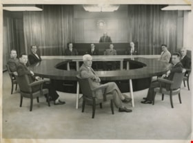
Municipal Council
https://search.heritageburnaby.ca/link/archivedescription55631
- Repository
- City of Burnaby Archives
- Date
- 1956
- Collection/Fonds
- Charles MacSorley fonds
- Description Level
- Item
- Physical Description
- 1 photograph : b&w ; 20.5 x 25.5 cm
- Scope and Content
- Photograph of the 1956 Burnaby Municipal Council in Council Chambers at Burnaby Municipal Hall. Identified in the photograph are (starting at centre, forefront and moving clockwise): Gerald Charlton, Fred Philps, Wesley Morrison, Arnold Hean, Ted Ward (Deputy Municipal Clerk), John Shaw (Municipal…
- Repository
- City of Burnaby Archives
- Date
- 1956
- Collection/Fonds
- Charles MacSorley fonds
- Physical Description
- 1 photograph : b&w ; 20.5 x 25.5 cm
- Description Level
- Item
- Record No.
- 486-025
- Access Restriction
- No restrictions
- Reproduction Restriction
- Reproduce for fair dealing purposes only
- Accession Number
- 2005-14
- Scope and Content
- Photograph of the 1956 Burnaby Municipal Council in Council Chambers at Burnaby Municipal Hall. Identified in the photograph are (starting at centre, forefront and moving clockwise): Gerald Charlton, Fred Philps, Wesley Morrison, Arnold Hean, Ted Ward (Deputy Municipal Clerk), John Shaw (Municipal Clerk), Reeve Charles MacSorley (in the back), two unkown members of staff, Samuel Hughes, William Philps and Doug Drummond.
- Subjects
- Officials - Alderman and Councillors
- Officials - Mayors and Reeves
- Buildings - Civic - City Halls
- Occupations - City Clerks
- Occupations - Civic Workers
- Names
- Charlton, Gerald
- Philps, Fred
- Morrison, Wesley
- Hean, Arnold F.C.
- Ward, Ted
- Shaw, John Horace "Jack"
- MacSorley, Charles W.
- Hughes, Samuel E.
- Philps, William P.
- Drummond, John D. "Doug"
- Media Type
- Photograph
- Photographer
- Cunningham, W.
- Notes
- Title based on contents of photograph
- Photographer's stamp on verso
- Notes on verso identify the people in the photograph
- Geographic Access
- Canada Way
- Street Address
- 4949 Canada Way
- Historic Neighbourhood
- Burnaby Lake (Historic Neighbourhood)
- Planning Study Area
- Douglas-Gilpin Area
Images

Building fatigue
https://search.heritageburnaby.ca/link/archivedescription36566
- Repository
- City of Burnaby Archives
- Date
- 1952
- Collection/Fonds
- Burnaby Historical Society fonds
- Description Level
- Item
- Physical Description
- 1 photograph : b&w ; 17.5 x 12.5 cm print
- Scope and Content
- Photograph of "BUILDING FATIGUE" inside the second Burnaby Municipal Hall.
- Repository
- City of Burnaby Archives
- Date
- 1952
- Collection/Fonds
- Burnaby Historical Society fonds
- Subseries
- Archie Miller subseries
- Physical Description
- 1 photograph : b&w ; 17.5 x 12.5 cm print
- Description Level
- Item
- Record No.
- 296-009
- Access Restriction
- No restrictions
- Reproduction Restriction
- Reproduce for fair dealing purposes only
- Accession Number
- BHS1992-36
- Scope and Content
- Photograph of "BUILDING FATIGUE" inside the second Burnaby Municipal Hall.
- Names
- Burnaby City Hall
- Media Type
- Photograph
- Photographer
- Dibble, Bob
- Notes
- Title taken from caption given to photograph in original pamphlet
- Photographs copies of originals used in "UNITE BURNABY" pamphlet which asked citizens to "VOTE YES" to the construction of a new Municipal Hall in Burnaby
- Geographic Access
- Kingsway
- Street Address
- 7282 Kingsway
- Historic Neighbourhood
- Edmonds (Historic Neighbourhood)
- Planning Study Area
- Stride Avenue Area
Images
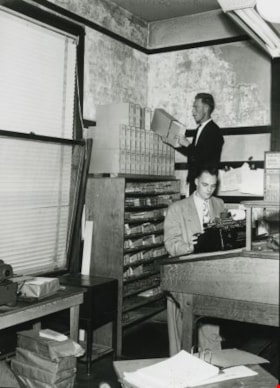
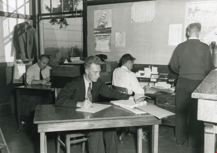
Interior of the Burnaby Municipal Hall
https://search.heritageburnaby.ca/link/archivedescription36568
- Repository
- City of Burnaby Archives
- Date
- 1952
- Collection/Fonds
- Burnaby Historical Society fonds
- Description Level
- Item
- Physical Description
- 1 photograph : b&w ; 12.5 x 17.5 cm print
- Scope and Content
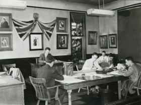
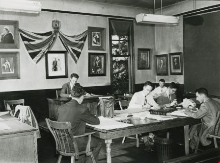
- Photograph of secretaries working inside the second Burnaby Municipal Hall.
- Repository
- City of Burnaby Archives
- Date
- 1952
- Collection/Fonds
- Burnaby Historical Society fonds
- Subseries
- Archie Miller subseries
- Physical Description
- 1 photograph : b&w ; 12.5 x 17.5 cm print
- Description Level
- Item
- Record No.
- 296-011
- Access Restriction
- No restrictions
- Reproduction Restriction
- Reproduce for fair dealing purposes only
- Accession Number
- BHS1992-36
- Scope and Content
- Photograph of secretaries working inside the second Burnaby Municipal Hall.
- Names
- Burnaby City Hall
- Media Type
- Photograph
- Photographer
- Dibble, Bob
- Notes
- Title based on contents of photograph
- Geographic Access
- Kingsway
- Street Address
- 7282 Kingsway
- Historic Neighbourhood
- Edmonds (Historic Neighbourhood)
- Planning Study Area
- Stride Avenue Area
Images

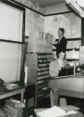
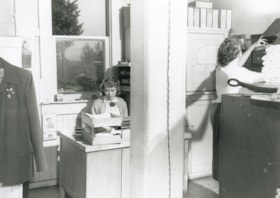
Over-crowded general office
https://search.heritageburnaby.ca/link/archivedescription36565
- Repository
- City of Burnaby Archives
- Date
- 1952
- Collection/Fonds
- Burnaby Historical Society fonds
- Description Level
- Item
- Physical Description
- 1 photograph : b&w ; 12.5 x 17.5 cm print
- Scope and Content
- Photograph of the "OVER-CROWDED GENERAL OFFICE" inside the second Burnaby Municipal Hall.
- Repository
- City of Burnaby Archives
- Date
- 1952
- Collection/Fonds
- Burnaby Historical Society fonds
- Subseries
- Archie Miller subseries
- Physical Description
- 1 photograph : b&w ; 12.5 x 17.5 cm print
- Description Level
- Item
- Record No.
- 296-008
- Access Restriction
- No restrictions
- Reproduction Restriction
- Reproduce for fair dealing purposes only
- Accession Number
- BHS1992-36
- Scope and Content
- Photograph of the "OVER-CROWDED GENERAL OFFICE" inside the second Burnaby Municipal Hall.
- Names
- Burnaby City Hall
- Media Type
- Photograph
- Photographer
- Dibble, Bob
- Notes
- Title taken from caption given to photograph in original pamphlet
- Photographs copies of originals used in "UNITE BURNABY" pamphlet which asked citizens to "VOTE YES" to the construction of a new Municipal Hall in Burnaby
- Geographic Access
- Kingsway
- Street Address
- 7282 Kingsway
- Historic Neighbourhood
- Edmonds (Historic Neighbourhood)
- Planning Study Area
- Stride Avenue Area
Images

Over-crowded police quarters
https://search.heritageburnaby.ca/link/archivedescription36567
- Repository
- City of Burnaby Archives
- Date
- 1952
- Collection/Fonds
- Burnaby Historical Society fonds
- Description Level
- Item
- Physical Description
- 1 photograph : b&w ; 12.5 x 17.5 cm print
- Scope and Content
- Photograph of the "OVER-CROWDED POLICE QUARTERS" inside the second Burnaby Municipal Hall.
- Repository
- City of Burnaby Archives
- Date
- 1952
- Collection/Fonds
- Burnaby Historical Society fonds
- Subseries
- Archie Miller subseries
- Physical Description
- 1 photograph : b&w ; 12.5 x 17.5 cm print
- Description Level
- Item
- Record No.
- 296-010
- Access Restriction
- No restrictions
- Reproduction Restriction
- Reproduce for fair dealing purposes only
- Accession Number
- BHS1992-36
- Scope and Content
- Photograph of the "OVER-CROWDED POLICE QUARTERS" inside the second Burnaby Municipal Hall.
- Media Type
- Photograph
- Photographer
- Dibble, Bob
- Notes
- Title taken from caption given to photograph in original pamphlet
- Photographs copies of originals used in "UNITE BURNABY" pamphlet which asked citizens to "VOTE YES" to the construction of a new Municipal Hall in Burnaby
- Geographic Access
- Kingsway
- Street Address
- 7282 Kingsway
- Historic Neighbourhood
- Edmonds (Historic Neighbourhood)
- Planning Study Area
- Stride Avenue Area
Images

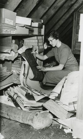
Plan filing room. Fire hazard???
https://search.heritageburnaby.ca/link/archivedescription36570
- Repository
- City of Burnaby Archives
- Date
- 1952
- Collection/Fonds
- Burnaby Historical Society fonds
- Description Level
- Item
- Physical Description
- 1 photograph : b&w ; 17.5 x 12.5 cm print
- Scope and Content
- Photograph of the "PLAN FILING ROOM [believed to be a] FIRE HAZZARD [sic]???" inside the second Burnaby Municipal Hall.
- Repository
- City of Burnaby Archives
- Date
- 1952
- Collection/Fonds
- Burnaby Historical Society fonds
- Subseries
- Archie Miller subseries
- Physical Description
- 1 photograph : b&w ; 17.5 x 12.5 cm print
- Description Level
- Item
- Record No.
- 296-013
- Access Restriction
- No restrictions
- Reproduction Restriction
- Reproduce for fair dealing purposes only
- Accession Number
- BHS1992-36
- Scope and Content
- Photograph of the "PLAN FILING ROOM [believed to be a] FIRE HAZZARD [sic]???" inside the second Burnaby Municipal Hall.
- Names
- Burnaby City Hall
- Media Type
- Photograph
- Photographer
- Dibble, Bob
- Notes
- Title taken from caption given to photograph in original pamphlet
- Photographs copies of originals used in "UNITE BURNABY" pamphlet which asked citizens to "VOTE YES" to the construction of a new Municipal Hall in Burnaby
- Geographic Access
- Kingsway
- Street Address
- 7282 Kingsway
- Historic Neighbourhood
- Edmonds (Historic Neighbourhood)
- Planning Study Area
- Stride Avenue Area
Images

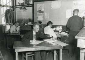
Staff using Council Chamber
https://search.heritageburnaby.ca/link/archivedescription36564
- Repository
- City of Burnaby Archives
- Date
- 1952
- Collection/Fonds
- Burnaby Historical Society fonds
- Description Level
- Item
- Physical Description
- 1 photograph : b&w ; 12.5 x 17.5 cm print
- Scope and Content
- Photograph of "STAFF USING COUNCIL CHAMBER" at the second Burnaby Municipal Hall.
- Repository
- City of Burnaby Archives
- Date
- 1952
- Collection/Fonds
- Burnaby Historical Society fonds
- Subseries
- Archie Miller subseries
- Physical Description
- 1 photograph : b&w ; 12.5 x 17.5 cm print
- Description Level
- Item
- Record No.
- 296-007
- Access Restriction
- No restrictions
- Reproduction Restriction
- Reproduce for fair dealing purposes only
- Accession Number
- BHS1992-36
- Scope and Content
- Photograph of "STAFF USING COUNCIL CHAMBER" at the second Burnaby Municipal Hall.
- Names
- Burnaby City Hall
- Media Type
- Photograph
- Photographer
- Dibble, Bob
- Notes
- Title taken from caption given to photograph in original pamphlet
- Photographs copies of originals used in "UNITE BURNABY" pamphlet which asked citizens to "VOTE YES" to the construction of a new Municipal Hall in Burnaby
- Geographic Access
- Kingsway
- Street Address
- 7282 Kingsway
- Historic Neighbourhood
- Edmonds (Historic Neighbourhood)
- Planning Study Area
- Stride Avenue Area
Images

Bob Hutton at Municipal Hall
https://search.heritageburnaby.ca/link/archivedescription37294
- Repository
- City of Burnaby Archives
- Date
- 1958
- Collection/Fonds
- Burnaby Historical Society fonds
- Description Level
- Item
- Physical Description
- 1 photograph : b&w ; 9 x 9 cm
- Scope and Content
- Photograph of a man identified as Bob Hutton outside Burnaby Municipal Hall. Two other men are visible in the picture, but neither is identified.
- Repository
- City of Burnaby Archives
- Date
- 1958
- Collection/Fonds
- Burnaby Historical Society fonds
- Subseries
- Norah Code subseries
- Physical Description
- 1 photograph : b&w ; 9 x 9 cm
- Description Level
- Item
- Record No.
- 345-015
- Access Restriction
- No restrictions
- Reproduction Restriction
- Reproduce for fair dealing purposes only
- Accession Number
- BHS1997-05
- Scope and Content
- Photograph of a man identified as Bob Hutton outside Burnaby Municipal Hall. Two other men are visible in the picture, but neither is identified.
- Subjects
- Buildings - Civic - City Halls
- Names
- Hutton, Bob
- Burnaby City Hall
- Media Type
- Photograph
- Photographer
- Code, Norah
- Notes
- Title based on contents of photograph.
- Photographs in this collection were taken and compiled by Norah Code, former editor of the "Burnaby Courier" newspaper during the course of her work for the newspaper.
- Geographic Access
- Canada Way
- Street Address
- 4949 Canada Way
- Historic Neighbourhood
- Burnaby Lake (Historic Neighbourhood)
- Planning Study Area
- Douglas-Gilpin Area
Images


Bob Hutton, outside Burnaby Municipal Hall
https://search.heritageburnaby.ca/link/archivedescription37300
- Repository
- City of Burnaby Archives
- Date
- 1958
- Collection/Fonds
- Burnaby Historical Society fonds
- Description Level
- Item
- Physical Description
- 1 photograph : b&w ; 9.5 x 14.5 cm
- Scope and Content
- Photograph of two men and one woman standing outside Burnaby Municipal Hall reading from a proclamation and addressing a fourth man who is seen to the far right holding a microphone. The microphone bears the call letters CKNW and the man holding it has been identified as Bob Hutton.
- Repository
- City of Burnaby Archives
- Date
- 1958
- Collection/Fonds
- Burnaby Historical Society fonds
- Subseries
- Norah Code subseries
- Physical Description
- 1 photograph : b&w ; 9.5 x 14.5 cm
- Description Level
- Item
- Record No.
- 345-021
- Access Restriction
- No restrictions
- Reproduction Restriction
- Reproduce for fair dealing purposes only
- Accession Number
- BHS1997-05
- Scope and Content
- Photograph of two men and one woman standing outside Burnaby Municipal Hall reading from a proclamation and addressing a fourth man who is seen to the far right holding a microphone. The microphone bears the call letters CKNW and the man holding it has been identified as Bob Hutton.
- Subjects
- Buildings - Civic - City Halls
- Names
- Hutton, Bob
- Burnaby City Hall
- Media Type
- Photograph
- Photographer
- Code, Norah
- Notes
- Photographs in this collection were taken and compiled by Norah Code, former editor of the "Burnaby Courier" newspaper during the course of her work for the newspaper.
- Geographic Access
- Canada Way
- Street Address
- 4949 Canada Way
- Historic Neighbourhood
- Burnaby Lake (Historic Neighbourhood)
- Planning Study Area
- Douglas-Gilpin Area
Images

![Burnaby Council, [1956] thumbnail](/media/hpo/_Data/_Archives_Images/_Unrestricted/204/204-803.jpg?width=280)
Burnaby Council
https://search.heritageburnaby.ca/link/archivedescription35943
- Repository
- City of Burnaby Archives
- Date
- [1956]
- Collection/Fonds
- Burnaby Historical Society fonds
- Description Level
- Item
- Physical Description
- 1 photograph : b&w ; 20.3 x 25.4 cm print
- Scope and Content
- Photograph of the Burnaby Council in chambers.
- Repository
- City of Burnaby Archives
- Date
- [1956]
- Collection/Fonds
- Burnaby Historical Society fonds
- Subseries
- Pioneer Tales subseries
- Physical Description
- 1 photograph : b&w ; 20.3 x 25.4 cm print
- Description Level
- Item
- Record No.
- 204-803
- Access Restriction
- No restrictions
- Reproduction Restriction
- Reproduce for fair dealing purposes only
- Accession Number
- BHS1988-03
- Scope and Content
- Photograph of the Burnaby Council in chambers.
- Subjects
- Officials - Alderman and Councillors
- Buildings - Civic - City Halls
- Officials - Mayors and Reeves
- Names
- Burnaby City Hall
- Media Type
- Photograph
- Photographer
- LeBlanc, Don
- Notes
- Title based on contents of photograph
- Geographic Access
- Canada Way
- Street Address
- 4949 Canada Way
- Historic Neighbourhood
- Burnaby Lake (Historic Neighbourhood)
- Planning Study Area
- Douglas-Gilpin Area
Images
![Burnaby Council, [1956] thumbnail](/media/hpo/_Data/_Archives_Images/_Unrestricted/204/204-803.jpg)
![Burnaby's first Municipal Hall, [between 1899 and 1911] (date of original), copied 1995 thumbnail](/media/hpo/_Data/_Archives_Images/_Unrestricted/316/316-006.jpg?width=280)
Burnaby's first Municipal Hall
https://search.heritageburnaby.ca/link/archivedescription37100
- Repository
- City of Burnaby Archives
- Date
- [between 1899 and 1911] (date of original), copied 1995
- Collection/Fonds
- Burnaby Historical Society fonds
- Description Level
- Item
- Physical Description
- 1 photograph : b&w ; 10 x 15 cm print
- Scope and Content
- Photograph of council members and others sitting and standing on the steps of Burnaby's first Municipal Hall.
- Repository
- City of Burnaby Archives
- Date
- [between 1899 and 1911] (date of original), copied 1995
- Collection/Fonds
- Burnaby Historical Society fonds
- Subseries
- Byrne family subseries
- Physical Description
- 1 photograph : b&w ; 10 x 15 cm print
- Description Level
- Item
- Record No.
- 316-006
- Access Restriction
- No restrictions
- Reproduction Restriction
- No known restrictions
- Accession Number
- BHS1995-04
- Scope and Content
- Photograph of council members and others sitting and standing on the steps of Burnaby's first Municipal Hall.
- Names
- Burnaby City Hall
- Media Type
- Photograph
- Notes
- Title based on contents of photograph
- Geographic Access
- Kingsway
- Street Address
- 7252 Kingsway
- Historic Neighbourhood
- Edmonds (Historic Neighbourhood)
- Planning Study Area
- Stride Avenue Area
Images
![Burnaby's first Municipal Hall, [between 1899 and 1911] (date of original), copied 1995 thumbnail](/media/hpo/_Data/_Archives_Images/_Unrestricted/316/316-006.jpg)
![Burnaby's new fleet of fire trucks, [1956 or 1957] thumbnail](/media/Hpo/_Data/_Archives_Images/_Unrestricted/205/226-001.jpg?width=280)
Burnaby's new fleet of fire trucks
https://search.heritageburnaby.ca/link/archivedescription36138
- Repository
- City of Burnaby Archives
- Date
- [1956 or 1957]
- Collection/Fonds
- Burnaby Historical Society fonds
- Description Level
- Item
- Physical Description
- 1 photograph : b&w ; 18.5 x 23.5 cm
- Scope and Content
- Photograph of the new fleet of Burnaby's 1956 American LaFrance pumper fire trucks lined in a row in front of the Municipal Hall. The fifth truck has its ladder extended. Reeve Charles MacSorley, Fire Chief William Menzies, and Councillor Fred Philps are standing in front of the second truck. There…
- Repository
- City of Burnaby Archives
- Date
- [1956 or 1957]
- Collection/Fonds
- Burnaby Historical Society fonds
- Physical Description
- 1 photograph : b&w ; 18.5 x 23.5 cm
- Description Level
- Item
- Record No.
- 226-001
- Access Restriction
- No restrictions
- Reproduction Restriction
- Reproduce for fair dealing purposes only
- Accession Number
- BHS1989-22
- Scope and Content
- Photograph of the new fleet of Burnaby's 1956 American LaFrance pumper fire trucks lined in a row in front of the Municipal Hall. The fifth truck has its ladder extended. Reeve Charles MacSorley, Fire Chief William Menzies, and Councillor Fred Philps are standing in front of the second truck. There is snow on the ground and the three men are wearing winter coats.
- Subjects
- Transportation - Fire Trucks
- Occupations - Fire Fighters
- Buildings - Civic - City Halls
- Officials - Alderman and Councillors
- Officials - Mayors and Reeves
- Media Type
- Photograph
- Photographer
- Dominion Photo Company
- Notes
- Title based on contents of photograph
- Other title info: photographer's negative no. 38487
- Street Address
- 4949 Canada Way
- Historic Neighbourhood
- Burnaby Lake (Historic Neighbourhood)
- Planning Study Area
- Douglas-Gilpin Area
Images
![Burnaby's new fleet of fire trucks, [1956 or 1957] thumbnail](/media/Hpo/_Data/_Archives_Images/_Unrestricted/205/226-001.jpg)

Burnaby's Third Municipal Hall - Canada Way
https://search.heritageburnaby.ca/link/archivedescription37289
- Repository
- City of Burnaby Archives
- Date
- 1958
- Collection/Fonds
- Burnaby Historical Society fonds
- Description Level
- Item
- Physical Description
- 1 photograph : b&w ; 13 x 17.7 cm
- Scope and Content
- Photograph of the exterior of Burnaby's third Municipal Hall. This hall was opened in 1956 on Grandview Highway (later, Canada Way) and it replaced the old hall at Kingsway and Edmonds Street.
- Repository
- City of Burnaby Archives
- Date
- 1958
- Collection/Fonds
- Burnaby Historical Society fonds
- Subseries
- Norah Code subseries
- Physical Description
- 1 photograph : b&w ; 13 x 17.7 cm
- Description Level
- Item
- Record No.
- 345-010
- Access Restriction
- No restrictions
- Reproduction Restriction
- Reproduce for fair dealing purposes only
- Accession Number
- BHS1997-05
- Scope and Content
- Photograph of the exterior of Burnaby's third Municipal Hall. This hall was opened in 1956 on Grandview Highway (later, Canada Way) and it replaced the old hall at Kingsway and Edmonds Street.
- Subjects
- Buildings - Civic - City Halls
- Names
- Burnaby City Hall
- Media Type
- Photograph
- Photographer
- Code, Norah
- Notes
- Title based on contents of photograph.
- Photographs in this collection were taken and compiled by Norah Code, former editor of the "Burnaby Courier" newspaper during the course of her work for the newspaper.
- Geographic Access
- Grandview Highway
- Canada Way
- Street Address
- 4949 Canada Way
- Historic Neighbourhood
- Burnaby Lake (Historic Neighbourhood)
- Planning Study Area
- Douglas-Gilpin Area
Images

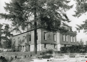
Exterior back of the Burnaby Municipal Hall
https://search.heritageburnaby.ca/link/archivedescription36562
- Repository
- City of Burnaby Archives
- Date
- 1952
- Collection/Fonds
- Burnaby Historical Society fonds
- Description Level
- Item
- Physical Description
- 1 photograph : b&w ; 12.5 x 17.5 cm print
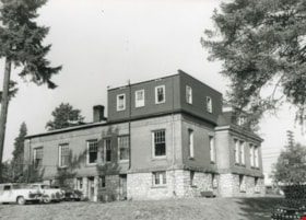
- Scope and Content
- Photograph of the exterior side and back of the Burnaby Municipal Hall. Parked cars are visible in the parking lot at the back of the Hall, and piles of large pipes are visible along the side. This was the second Municipal Hall built.
- Repository
- City of Burnaby Archives
- Date
- 1952
- Collection/Fonds
- Burnaby Historical Society fonds
- Subseries
- Archie Miller subseries
- Physical Description
- 1 photograph : b&w ; 12.5 x 17.5 cm print
- Description Level
- Item
- Record No.
- 296-005
- Access Restriction
- No restrictions
- Reproduction Restriction
- Reproduce for fair dealing purposes only
- Accession Number
- BHS1992-36
- Scope and Content
- Photograph of the exterior side and back of the Burnaby Municipal Hall. Parked cars are visible in the parking lot at the back of the Hall, and piles of large pipes are visible along the side. This was the second Municipal Hall built.
- Subjects
- Buildings - Civic - City Halls
- Names
- Burnaby City Hall
- Media Type
- Photograph
- Photographer
- Dibble, Bob
- Notes
- Title based on contents of photograph
- Geographic Access
- Kingsway
- Street Address
- 7282 Kingsway
- Historic Neighbourhood
- Edmonds (Historic Neighbourhood)
- Planning Study Area
- Stride Avenue Area
Images
Exterior of the Burnaby Municipal Hall
https://search.heritageburnaby.ca/link/archivedescription36560
- Repository
- City of Burnaby Archives
- Date
- 1952
- Collection/Fonds
- Burnaby Historical Society fonds
- Description Level
- Item
- Physical Description
- 1 photograph : b&w ; 12.5 x 17.5 cm print
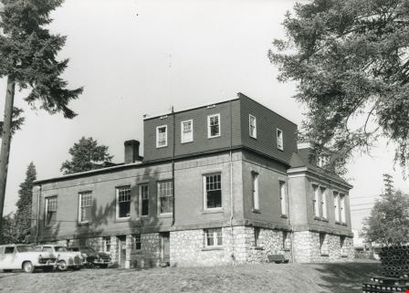
- Scope and Content
- Photograph of the exterior side and back of the Burnaby Municipal Hall. Parked cars are visible in the parking lot at the back of the Hall, and piles of large pipes and wooden 2" x 4"s are both visible along the side. This was the second Municipal Hall built.
- Repository
- City of Burnaby Archives
- Date
- 1952
- Collection/Fonds
- Burnaby Historical Society fonds
- Subseries
- Archie Miller subseries
- Physical Description
- 1 photograph : b&w ; 12.5 x 17.5 cm print
- Description Level
- Item
- Record No.
- 296-003
- Access Restriction
- No restrictions
- Reproduction Restriction
- Reproduce for fair dealing purposes only
- Accession Number
- BHS1992-36
- Scope and Content
- Photograph of the exterior side and back of the Burnaby Municipal Hall. Parked cars are visible in the parking lot at the back of the Hall, and piles of large pipes and wooden 2" x 4"s are both visible along the side. This was the second Municipal Hall built.
- Subjects
- Buildings - Civic - City Halls
- Names
- Burnaby City Hall
- Media Type
- Photograph
- Photographer
- Dibble, Bob
- Notes
- Title based on contents of photograph
- Geographic Access
- Kingsway
- Street Address
- 7282 Kingsway
- Historic Neighbourhood
- Edmonds (Historic Neighbourhood)
- Planning Study Area
- Stride Avenue Area
Images