Narrow Results By
Subject
- Animals - Horses 1
- Buildings - Civic - Fire Halls 1
- Buildings - Civic - Libraries 2
- Buildings - Commercial - Automobile Dealerships 1
- Buildings - Commercial - Grocery Stores 1
- Buildings - Commercial - Hotels and Motels 1
- Buildings - Commercial - Service Stations 1
- Buildings - Commercial - Stores 1
- Clothing - Uniforms 1
- Construction 4
- Geographic Features - Forests 1
- Geographic Features - Roads 4

Barnet Wagon Road
https://search.heritageburnaby.ca/link/archivedescription38307
- Repository
- City of Burnaby Archives
- Date
- June 1903 (date of original), copied ca. 1990
- Collection/Fonds
- Burnaby Historical Society fonds
- Description Level
- Item
- Physical Description
- 1 photograph : b&w ; 10 x 15 cm print
- Scope and Content
- Photograph of the Barnet Wagon Road looking east, near Barnet and Hastings.
- Repository
- City of Burnaby Archives
- Date
- June 1903 (date of original), copied ca. 1990
- Collection/Fonds
- Burnaby Historical Society fonds
- Subseries
- Photographs subseries
- Physical Description
- 1 photograph : b&w ; 10 x 15 cm print
- Description Level
- Item
- Record No.
- 403-002
- Access Restriction
- No restrictions
- Reproduction Restriction
- No known restrictions
- Accession Number
- BHS2007-04
- Scope and Content
- Photograph of the Barnet Wagon Road looking east, near Barnet and Hastings.
- Subjects
- Land Clearing
- Geographic Features - Roads
- Media Type
- Photograph
- Notes
- Title based on contents of photograph
- Geographic Access
- Barnet Road
- Hastings Street
- Historic Neighbourhood
- Lochdale (Historic Neighbourhood)
- Planning Study Area
- Westridge Area
Images

Bill Grieve's Car Sales
https://search.heritageburnaby.ca/link/archivedescription66401
- Repository
- City of Burnaby Archives
- Date
- 1948
- Collection/Fonds
- Grieve family fonds
- Description Level
- Item
- Physical Description
- 1 photograph : sepia ; 5.5 x 8 cm
- Scope and Content
- Photograph of the exterior of "Bill Grieve's Car Sales" on Hastings Street.
- Repository
- City of Burnaby Archives
- Date
- 1948
- Collection/Fonds
- Grieve family fonds
- Physical Description
- 1 photograph : sepia ; 5.5 x 8 cm
- Description Level
- Item
- Record No.
- 523-015
- Access Restriction
- No restrictions
- Reproduction Restriction
- No known restrictions
- Accession Number
- 2011-04
- Scope and Content
- Photograph of the exterior of "Bill Grieve's Car Sales" on Hastings Street.
- Media Type
- Photograph
- Notes
- Title based on contents of photograph
- Note on verso of photograph reads: "1948"
- Geographic Access
- Hastings Street
- Historic Neighbourhood
- Capitol Hill (Historic Neighbourhood)
- Planning Study Area
- Capitol Hill Area
![Boundary Road and Hastings Street Intersection, [1943 or 1944] (date of original), copied 1991 thumbnail](/media/hpo/_Data/_Archives_Images/_Unrestricted/370/370-229.jpg?width=280)
Boundary Road and Hastings Street Intersection
https://search.heritageburnaby.ca/link/archivedescription37641
- Repository
- City of Burnaby Archives
- Date
- [1943 or 1944] (date of original), copied 1991
- Collection/Fonds
- Burnaby Historical Society fonds
- Description Level
- Item
- Physical Description
- 1 photograph : b&w ; 3.2 x 5.3 cm print on contact sheet 20.2 x 25.3 cm
- Scope and Content
- Photograph of the intersection of Boundary Road and Hastings Street facing east from the southwest corner. A streetcar has a sign advertising Victory Bonds.
- Repository
- City of Burnaby Archives
- Date
- [1943 or 1944] (date of original), copied 1991
- Collection/Fonds
- Burnaby Historical Society fonds
- Subseries
- Burnaby Image Bank subseries
- Physical Description
- 1 photograph : b&w ; 3.2 x 5.3 cm print on contact sheet 20.2 x 25.3 cm
- Description Level
- Item
- Record No.
- 370-229
- Access Restriction
- No restrictions
- Reproduction Restriction
- No known restrictions
- Accession Number
- BHS1999-03
- Scope and Content
- Photograph of the intersection of Boundary Road and Hastings Street facing east from the southwest corner. A streetcar has a sign advertising Victory Bonds.
- Media Type
- Photograph
- Notes
- Title based on contents of photograph
- 1 b&w copy negative accompanying
- Geographic Access
- Boundary Road
- Hastings Street
- Historic Neighbourhood
- Vancouver Heights (Historic Neighbourhood)
- Planning Study Area
- Burnaby Heights Area
- Willingdon Heights Area
Images
![Boundary Road and Hastings Street Intersection, [1943 or 1944] (date of original), copied 1991 thumbnail](/media/hpo/_Data/_Archives_Images/_Unrestricted/370/370-229.jpg)
![Construction of Martin's Auto Villa, [1946] thumbnail](/media/hpo/_Data/_BVM_Images/2019/2019_0037_0021_001.jpg?width=280)
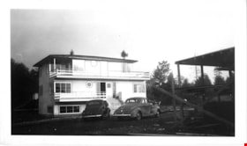
Construction of Martin's Auto Villa
https://search.heritageburnaby.ca/link/museumdescription15046
- Repository
- Burnaby Village Museum
- Date
- [1946]
- Collection/Fonds
- Elmer Wilson Martin fonds
- Description Level
- Item
- Physical Description
- 1 photograph : b&w ; 7 x 11.5 cm
- Scope and Content
- Photograph of Elmer Wilson Martin (right) standing with an unidentified man outside of Martin's Auto Villa which is under construction at 6604 Hastings Street, Burnaby (after 1950 - 6574 Hastings Street).
- Repository
- Burnaby Village Museum
- Collection/Fonds
- Elmer Wilson Martin fonds
- Description Level
- Item
- Physical Description
- 1 photograph : b&w ; 7 x 11.5 cm
- Scope and Content
- Photograph of Elmer Wilson Martin (right) standing with an unidentified man outside of Martin's Auto Villa which is under construction at 6604 Hastings Street, Burnaby (after 1950 - 6574 Hastings Street).
- Subjects
- Construction
- Geographic Access
- Hastings Street
- Street Address
- 6574 Hastings Street
- Accession Code
- BV019.37.21
- Access Restriction
- No restrictions
- Reproduction Restriction
- No known restrictions
- Date
- [1946]
- Media Type
- Photograph
- Historic Neighbourhood
- Lochdale (Historic Neighbourhood)
- Planning Study Area
- Lochdale Area
- Scan Resolution
- 600
- Scan Date
- February 4, 2021
- Scale
- 100
- Notes
- Title based on contents of photograph
- Note in blue ink on verso of photograph reads: "Right Mr. E.W. Martin / P.Eng"
- Stamp on verso of photograph reads: "663"
Images
![Construction of Martin's Auto Villa, [1946] thumbnail](/media/hpo/_Data/_BVM_Images/2019/2019_0037_0021_001.jpg)
![Delta Avenue and Hastings Street intersection, [1943 or 1944] (date of original), copied 1991 thumbnail](/media/hpo/_Data/_Archives_Images/_Unrestricted/370/370-228.jpg?width=280)
Delta Avenue and Hastings Street intersection
https://search.heritageburnaby.ca/link/archivedescription37640
- Repository
- City of Burnaby Archives
- Date
- [1943 or 1944] (date of original), copied 1991
- Collection/Fonds
- Burnaby Historical Society fonds
- Description Level
- Item
- Physical Description
- 1 photograph : b&w ; 3.2 x 5.3 cm print on contact sheet 20.2 x 25.3 cm
- Scope and Content
- Photograph of the intersection at Delta Avenue and Hastings Street. The photograph was taken from the southwest corner, facing north.
- Repository
- City of Burnaby Archives
- Date
- [1943 or 1944] (date of original), copied 1991
- Collection/Fonds
- Burnaby Historical Society fonds
- Subseries
- Burnaby Image Bank subseries
- Physical Description
- 1 photograph : b&w ; 3.2 x 5.3 cm print on contact sheet 20.2 x 25.3 cm
- Description Level
- Item
- Record No.
- 370-228
- Access Restriction
- No restrictions
- Reproduction Restriction
- No known restrictions
- Accession Number
- BHS1999-03
- Scope and Content
- Photograph of the intersection at Delta Avenue and Hastings Street. The photograph was taken from the southwest corner, facing north.
- Subjects
- Geographic Features - Roads
- Media Type
- Photograph
- Notes
- Title based on contents of photograph
- 1 b&w copy negative accompanying
- Geographic Access
- Delta Avenue
- Hastings Street
- Historic Neighbourhood
- Capitol Hill (Historic Neighbourhood)
- Planning Study Area
- Capitol Hill Area
Images
![Delta Avenue and Hastings Street intersection, [1943 or 1944] (date of original), copied 1991 thumbnail](/media/hpo/_Data/_Archives_Images/_Unrestricted/370/370-228.jpg)
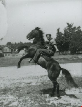
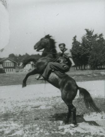
Dick Wirick on horseback
https://search.heritageburnaby.ca/link/archivedescription37477
- Repository
- City of Burnaby Archives
- Date
- August 1, 1945 (date of original), copied 1991
- Collection/Fonds
- Burnaby Historical Society fonds
- Description Level
- Item
- Physical Description
- 1 photograph : b&w ; 4.6 x 3.4 cm print on contact sheet 20.2 x 25.3 cm
- Scope and Content
- Photograph of Dick Wirick riding his horse, Bus, on the 5700 block of Hastings Street. The horse is rearing. Capitol Hill School can be seen in the background.
- Repository
- City of Burnaby Archives
- Date
- August 1, 1945 (date of original), copied 1991
- Collection/Fonds
- Burnaby Historical Society fonds
- Subseries
- Burnaby Image Bank subseries
- Physical Description
- 1 photograph : b&w ; 4.6 x 3.4 cm print on contact sheet 20.2 x 25.3 cm
- Description Level
- Item
- Record No.
- 370-065
- Access Restriction
- No restrictions
- Reproduction Restriction
- No known restrictions
- Accession Number
- BHS1999-03
- Scope and Content
- Photograph of Dick Wirick riding his horse, Bus, on the 5700 block of Hastings Street. The horse is rearing. Capitol Hill School can be seen in the background.
- Subjects
- Animals - Horses
- Names
- Wirick, Dick
- Media Type
- Photograph
- Notes
- Title based on contents of photograph
- 1 b&w copy negative accompanying
- Geographic Access
- Hastings Street
- Historic Neighbourhood
- Capitol Hill (Historic Neighbourhood)
- Planning Study Area
- Capitol Hill Area
Images
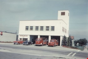
Fire hall no. 1
https://search.heritageburnaby.ca/link/museumdescription1299
- Repository
- Burnaby Village Museum
- Date
- 1947 (date of original)
- Collection/Fonds
- Burnaby Village Museum Photograph collection
- Description Level
- Item
- Physical Description
- 1 photograph : col. ; 10 x 15 cm print
- Scope and Content
- Photograph of Burnaby Fire Hall No. 1 at Willingdon and Hastings, the first purpose built fire hall in Burnaby. The hall is a two storey modern concrete building with three large bays. Fire trucks are parked in front of the hall, along with two cars.
- Repository
- Burnaby Village Museum
- Collection/Fonds
- Burnaby Village Museum Photograph collection
- Description Level
- Item
- Physical Description
- 1 photograph : col. ; 10 x 15 cm print
- Scope and Content
- Photograph of Burnaby Fire Hall No. 1 at Willingdon and Hastings, the first purpose built fire hall in Burnaby. The hall is a two storey modern concrete building with three large bays. Fire trucks are parked in front of the hall, along with two cars.
- Names
- Burnaby Fire Department
- Geographic Access
- Willingdon Avenue
- Hastings Street
- Accession Code
- BV998.31.8
- Access Restriction
- No restrictions
- Reproduction Restriction
- No known restrictions
- Date
- 1947 (date of original)
- Media Type
- Photograph
- Historic Neighbourhood
- Vancouver Heights (Historic Neighbourhood)
- Planning Study Area
- Burnaby Heights Area
- Scan Resolution
- 600
- Scan Date
- 01-Jun-09
- Scale
- 100
- Notes
- Title based on contents of photograph
- Typed sticker on verso of photograph reads: "First new Burnaby firehall [sic] No. 1 Willingdon & Hastings 1947"
- Address sticker on verso of photograph reads: "MR & MRS F BLAKE 4165 PANDORA ST BURNABY BC V5C 2B2"
Images

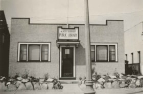
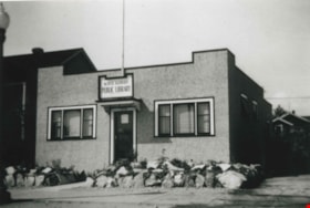
First North Burnaby Public Library
https://search.heritageburnaby.ca/link/archivedescription36137
- Repository
- City of Burnaby Archives
- Date
- 1941
- Collection/Fonds
- Burnaby Historical Society fonds
- Description Level
- Item
- Physical Description
- 1 photograph : b&w ; 5 x 8 cm
- Scope and Content
- Photograph of the North Burnaby Public Library at Hastings Street and Gilmore Avenue, the first North Burnaby Public Library.
- Repository
- City of Burnaby Archives
- Date
- 1941
- Collection/Fonds
- Burnaby Historical Society fonds
- Physical Description
- 1 photograph : b&w ; 5 x 8 cm
- Description Level
- Item
- Record No.
- 225-004
- Access Restriction
- No restrictions
- Reproduction Restriction
- No known restrictions
- Accession Number
- BHS1989-22
- Scope and Content
- Photograph of the North Burnaby Public Library at Hastings Street and Gilmore Avenue, the first North Burnaby Public Library.
- Subjects
- Buildings - Civic - Libraries
- Media Type
- Photograph
- Geographic Access
- Hastings Street
- Gilmore Avenue
- Street Address
- 4147 Hastings Street
- Historic Neighbourhood
- Vancouver Heights (Historic Neighbourhood)
- Planning Study Area
- Burnaby Heights Area
Images
![Floyd Wirick, [Between 1935 and 1940] (date of original), copied 1991 thumbnail](/media/hpo/_Data/_Archives_Images/_Unrestricted/370/370-074.jpg?width=280)
Floyd Wirick
https://search.heritageburnaby.ca/link/archivedescription37486
- Repository
- City of Burnaby Archives
- Date
- [Between 1935 and 1940] (date of original), copied 1991
- Collection/Fonds
- Burnaby Historical Society fonds
- Description Level
- Item
- Physical Description
- 1 photograph : b&w ; 4.5 x 2.6 cm print on contact sheet 20.2 x 25.3 cm
- Scope and Content
- Photograph of Floyd Wirick sitting on a wheelbarrow in backyard of 5870 Hastings Street. Gardening tools, a shed and an unidentified man are in the background.
- Repository
- City of Burnaby Archives
- Date
- [Between 1935 and 1940] (date of original), copied 1991
- Collection/Fonds
- Burnaby Historical Society fonds
- Subseries
- Burnaby Image Bank subseries
- Physical Description
- 1 photograph : b&w ; 4.5 x 2.6 cm print on contact sheet 20.2 x 25.3 cm
- Description Level
- Item
- Record No.
- 370-074
- Access Restriction
- No restrictions
- Reproduction Restriction
- No restrictions
- Accession Number
- BHS1999-03
- Scope and Content
- Photograph of Floyd Wirick sitting on a wheelbarrow in backyard of 5870 Hastings Street. Gardening tools, a shed and an unidentified man are in the background.
- Subjects
- Transportation - Wheelbarrows
- Names
- Wirick, Floyd
- Media Type
- Photograph
- Notes
- Title based on contents of photograph
- 1 b&w copy negative accompanying
- Geographic Access
- Hastings Street
- Street Address
- 5870 Hastings Street
- Historic Neighbourhood
- Capitol Hill (Historic Neighbourhood)
- Planning Study Area
- Parkcrest-Aubrey Area
Images
![Floyd Wirick, [Between 1935 and 1940] (date of original), copied 1991 thumbnail](/media/hpo/_Data/_Archives_Images/_Unrestricted/370/370-074.jpg)
![Gas Delivery Truck, [194-] (date of original), copied 1991 thumbnail](/media/hpo/_Data/_Archives_Images/_Unrestricted/370/370-012.jpg?width=280)
Gas Delivery Truck
https://search.heritageburnaby.ca/link/archivedescription37424
- Repository
- City of Burnaby Archives
- Date
- [194-] (date of original), copied 1991
- Collection/Fonds
- Burnaby Historical Society fonds
- Description Level
- Item
- Physical Description
- 1 photograph : b&w ; 3.8 x 4.7 cm print on contact sheet 20.2 x 25.4 cm
- Scope and Content
- Photograph of a gas delivery truck belonging to William "Bill" Kask, Sr., at Walsh Motors at 4161 Hastings Street. The side of the truck reads, "Richfield."
- Repository
- City of Burnaby Archives
- Date
- [194-] (date of original), copied 1991
- Collection/Fonds
- Burnaby Historical Society fonds
- Subseries
- Burnaby Image Bank subseries
- Physical Description
- 1 photograph : b&w ; 3.8 x 4.7 cm print on contact sheet 20.2 x 25.4 cm
- Description Level
- Item
- Record No.
- 370-012
- Access Restriction
- No restrictions
- Reproduction Restriction
- Reproduce for fair dealing purposes only
- Accession Number
- BHS1999-03
- Scope and Content
- Photograph of a gas delivery truck belonging to William "Bill" Kask, Sr., at Walsh Motors at 4161 Hastings Street. The side of the truck reads, "Richfield."
- Names
- Walsh Motors
- Media Type
- Photograph
- Notes
- Title based on contents of photograph
- 1 b&w copy negative accompanying
- Geographic Access
- Hastings Street
- Street Address
- 4161 Hastings Street
- Historic Neighbourhood
- Vancouver Heights (Historic Neighbourhood)
- Planning Study Area
- Burnaby Heights Area
Images
![Gas Delivery Truck, [194-] (date of original), copied 1991 thumbnail](/media/hpo/_Data/_Archives_Images/_Unrestricted/370/370-012.jpg)
![Harry Royle and man outside Harry's confectionery store, [194-] thumbnail](/media/hpo/_Data/_BVM_Images/2005/2005_0020_0010_001.jpg?width=280)
Harry Royle and man outside Harry's confectionery store
https://search.heritageburnaby.ca/link/museumdescription1884
- Repository
- Burnaby Village Museum
- Date
- [194-]
- Collection/Fonds
- Harry Royle fonds
- Description Level
- Item
- Physical Description
- 1 photograph : 11.5 x 7 cm
- Scope and Content
- Photograph of Harry Royle with unidentified male friend, standing in front of Harry's confectionery store located at 5527 Hastings Street, Burnaby.
- Repository
- Burnaby Village Museum
- Collection/Fonds
- Harry Royle fonds
- Description Level
- Item
- Physical Description
- 1 photograph : 11.5 x 7 cm
- Scope and Content
- Photograph of Harry Royle with unidentified male friend, standing in front of Harry's confectionery store located at 5527 Hastings Street, Burnaby.
- Geographic Access
- Hastings Street
- Street Address
- 5527 Hastings Street
- Accession Code
- BV005.20.10
- Access Restriction
- No restrictions
- Reproduction Restriction
- No known restrictions
- Date
- [194-]
- Media Type
- Photograph
- Historic Neighbourhood
- Capitol Hill (Historic Neighbourhood)
- Planning Study Area
- Capitol Hill Area
- Scan Resolution
- 600
- Scan Date
- 2024-01-15
- Notes
- Title based on contents of photograph
Images
![Harry Royle and man outside Harry's confectionery store, [194-] thumbnail](/media/hpo/_Data/_BVM_Images/2005/2005_0020_0010_001.jpg)
![Harry Royle and woman outside Harry's confectionery store, [194-] thumbnail](/media/hpo/_Data/_BVM_Images/2005/2005_0020_0011_001.jpg?width=280)
Harry Royle and woman outside Harry's confectionery store
https://search.heritageburnaby.ca/link/museumdescription1885
- Repository
- Burnaby Village Museum
- Date
- [194-]
- Collection/Fonds
- Harry Royle fonds
- Description Level
- Item
- Physical Description
- 1 photograph : 11.5 x 7 cm
- Scope and Content
- Photograph of Harry Royle standing with unidentified woman in front of Harry's confectionery store located at 5527 Hastings Street, Burnaby. The woman could be Harry's wife,
- Repository
- Burnaby Village Museum
- Collection/Fonds
- Harry Royle fonds
- Description Level
- Item
- Physical Description
- 1 photograph : 11.5 x 7 cm
- Scope and Content
- Photograph of Harry Royle standing with unidentified woman in front of Harry's confectionery store located at 5527 Hastings Street, Burnaby. The woman could be Harry's wife,
- Geographic Access
- Hastings Street
- Street Address
- 5527 Hastings Street
- Accession Code
- BV005.20.11
- Access Restriction
- No restrictions
- Reproduction Restriction
- No known restrictions
- Date
- [194-]
- Media Type
- Photograph
- Historic Neighbourhood
- Capitol Hill (Historic Neighbourhood)
- Planning Study Area
- Capitol Hill Area
- Scan Resolution
- 600
- Scan Date
- 2024-01-15
- Notes
- Title based on contents of photograph
Images
![Harry Royle and woman outside Harry's confectionery store, [194-] thumbnail](/media/hpo/_Data/_BVM_Images/2005/2005_0020_0011_001.jpg)
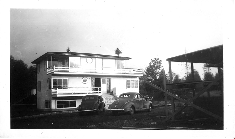
Martin's auto villa
https://search.heritageburnaby.ca/link/museumdescription15048
- Repository
- Burnaby Village Museum
- Date
- 5 Oct. 1946
- Collection/Fonds
- Elmer Wilson Martin fonds
- Description Level
- Item
- Physical Description
- 1 photograph : b&w ; 7 x 11.5 cm
- Scope and Content
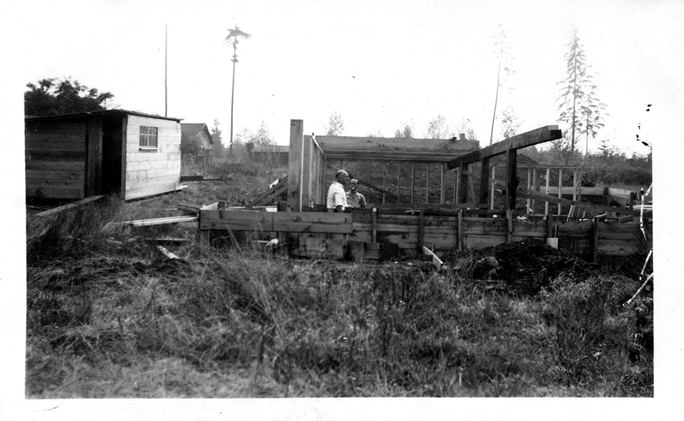
- Photograph of two cars parked outside of Martin's Auto Villa at 6604 Hastings Street (after 1950 - 6574 Hastings Street). Framework of a building is visible to the right and appears to be under construction.
- Repository
- Burnaby Village Museum
- Collection/Fonds
- Elmer Wilson Martin fonds
- Description Level
- Item
- Physical Description
- 1 photograph : b&w ; 7 x 11.5 cm
- Scope and Content
- Photograph of two cars parked outside of Martin's Auto Villa at 6604 Hastings Street (after 1950 - 6574 Hastings Street). Framework of a building is visible to the right and appears to be under construction.
- Subjects
- Construction
- Geographic Access
- Hastings Street
- Street Address
- 6574 Hastings Street
- Accession Code
- BV019.37.22
- Access Restriction
- No restrictions
- Reproduction Restriction
- No known restrictions
- Date
- 5 Oct. 1946
- Media Type
- Photograph
- Historic Neighbourhood
- Lochdale (Historic Neighbourhood)
- Planning Study Area
- Lochdale Area
- Scan Resolution
- 600
- Scan Date
- February 4, 2021
- Scale
- 100
- Notes
- Title based on contents of photograph
- Note in black ink on verso of photograph reads: "Oct. 5th 1946"
- Stamp on verso of photograph reads: "992"
Images
Martin's Auto Villa
https://search.heritageburnaby.ca/link/museumdescription15062
- Repository
- Burnaby Village Museum
- Date
- 5 Oct. 1946
- Collection/Fonds
- Elmer Wilson Martin fonds
- Description Level
- Item
- Physical Description
- 1 photograph : b&w ; 7 x 11.5 cm
- Scope and Content
- Photograph of Martin's Auto Villa on Hastings Street. Two cars are parked outside. A building in the foreground of the photograph appears to be under construction.
- Repository
- Burnaby Village Museum
- Collection/Fonds
- Elmer Wilson Martin fonds
- Description Level
- Item
- Physical Description
- 1 photograph : b&w ; 7 x 11.5 cm
- Scope and Content
- Photograph of Martin's Auto Villa on Hastings Street. Two cars are parked outside. A building in the foreground of the photograph appears to be under construction.
- Geographic Access
- Hastings Street
- Street Address
- 6574 Hastings Street
- Accession Code
- BV019.37.37
- Access Restriction
- No restrictions
- Reproduction Restriction
- No known restrictions
- Date
- 5 Oct. 1946
- Media Type
- Photograph
- Historic Neighbourhood
- Lochdale (Historic Neighbourhood)
- Planning Study Area
- Lochdale Area
- Scan Resolution
- 600
- Scan Date
- February 4, 2021
- Scale
- 100
- Notes
- Title based on contents of photograph
- Note in blue ink on verso of photograph reads: "Oct. 5th 1946"
- Stamp in black ink on verso of photograph reads: "992"
Images

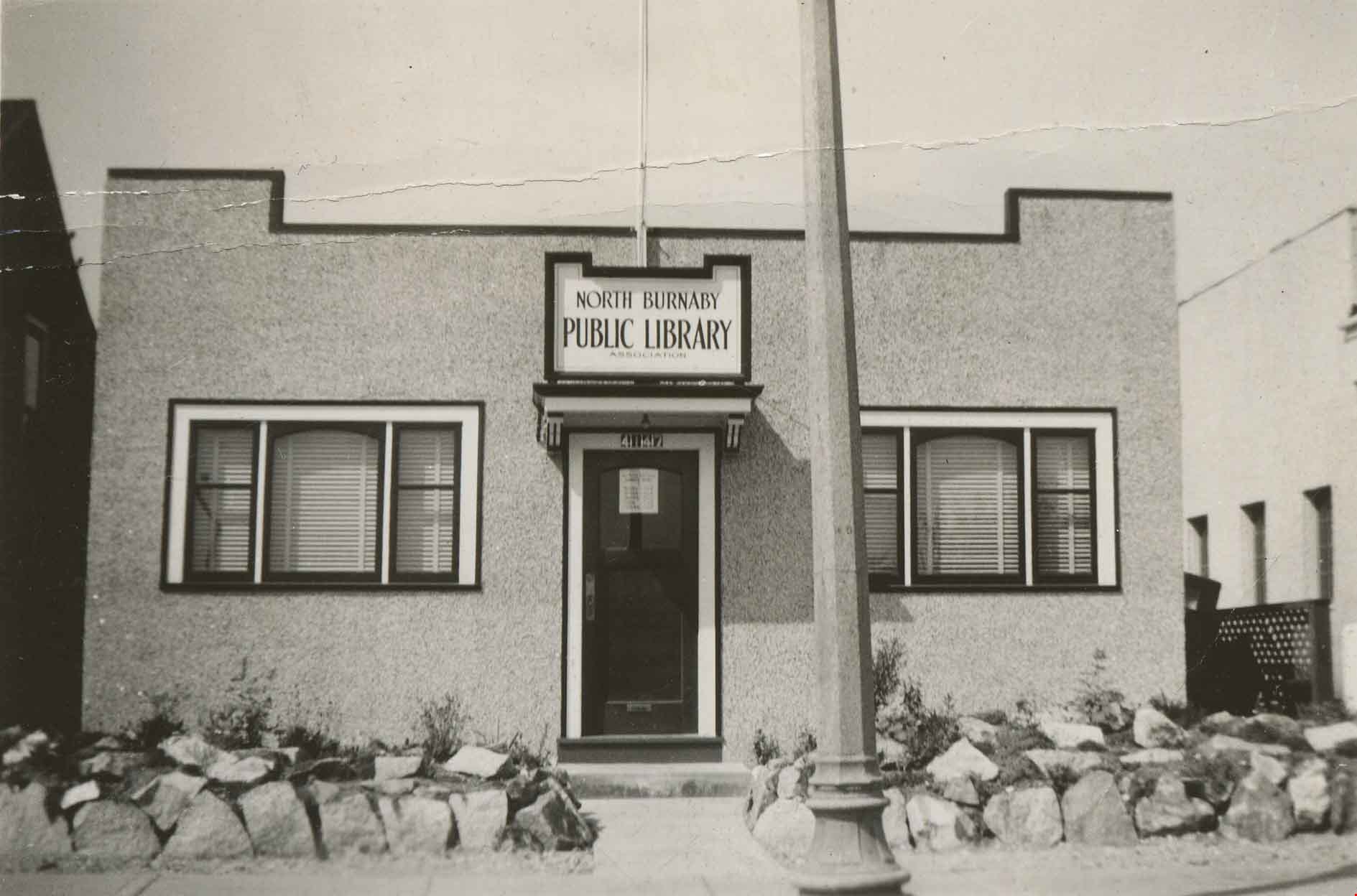
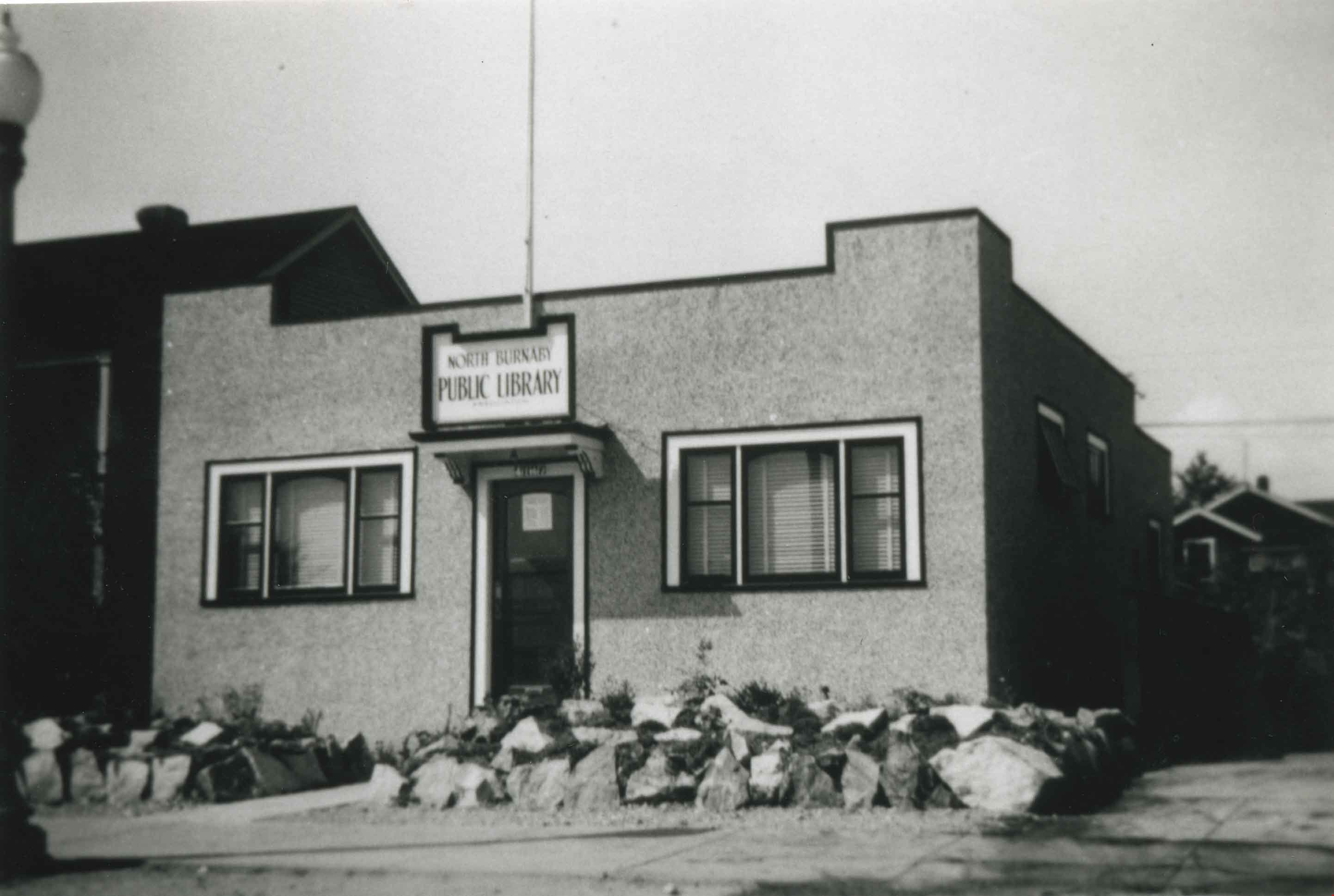
North Burnaby Public Library
https://search.heritageburnaby.ca/link/archivedescription36783
- Repository
- City of Burnaby Archives
- Date
- 1941 (date of original), copied 1992
- Collection/Fonds
- Burnaby Historical Society fonds
- Description Level
- Item
- Physical Description
- 1 photograph : b&w ; 8.3 x 12.3 cm print
- Scope and Content
- Photograph of the North Burnaby Public Library at Hastings Street and Gilmore Avenue, the first Burnaby Public Library.
- Repository
- City of Burnaby Archives
- Date
- 1941 (date of original), copied 1992
- Collection/Fonds
- Burnaby Historical Society fonds
- Subseries
- Burnaby Centennial Anthology subseries
- Physical Description
- 1 photograph : b&w ; 8.3 x 12.3 cm print
- Description Level
- Item
- Record No.
- 315-140
- Access Restriction
- No restrictions
- Reproduction Restriction
- No known restrictions
- Accession Number
- BHS1994-04
- Scope and Content
- Photograph of the North Burnaby Public Library at Hastings Street and Gilmore Avenue, the first Burnaby Public Library.
- Subjects
- Buildings - Civic - Libraries
- Media Type
- Photograph
- Geographic Access
- Hastings Street
- Gilmore Avenue
- Street Address
- 4147 Hastings Street
- Historic Neighbourhood
- Vancouver Heights (Historic Neighbourhood)
- Planning Study Area
- Burnaby Heights Area
Images
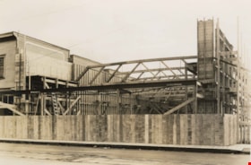
Safeway construction
https://search.heritageburnaby.ca/link/archivedescription38680
- Repository
- City of Burnaby Archives
- Date
- 1941
- Collection/Fonds
- Burnaby Historical Society fonds
- Description Level
- Item
- Physical Description
- 1 photograph : b&w ; 11.5 x 17 cm
- Scope and Content
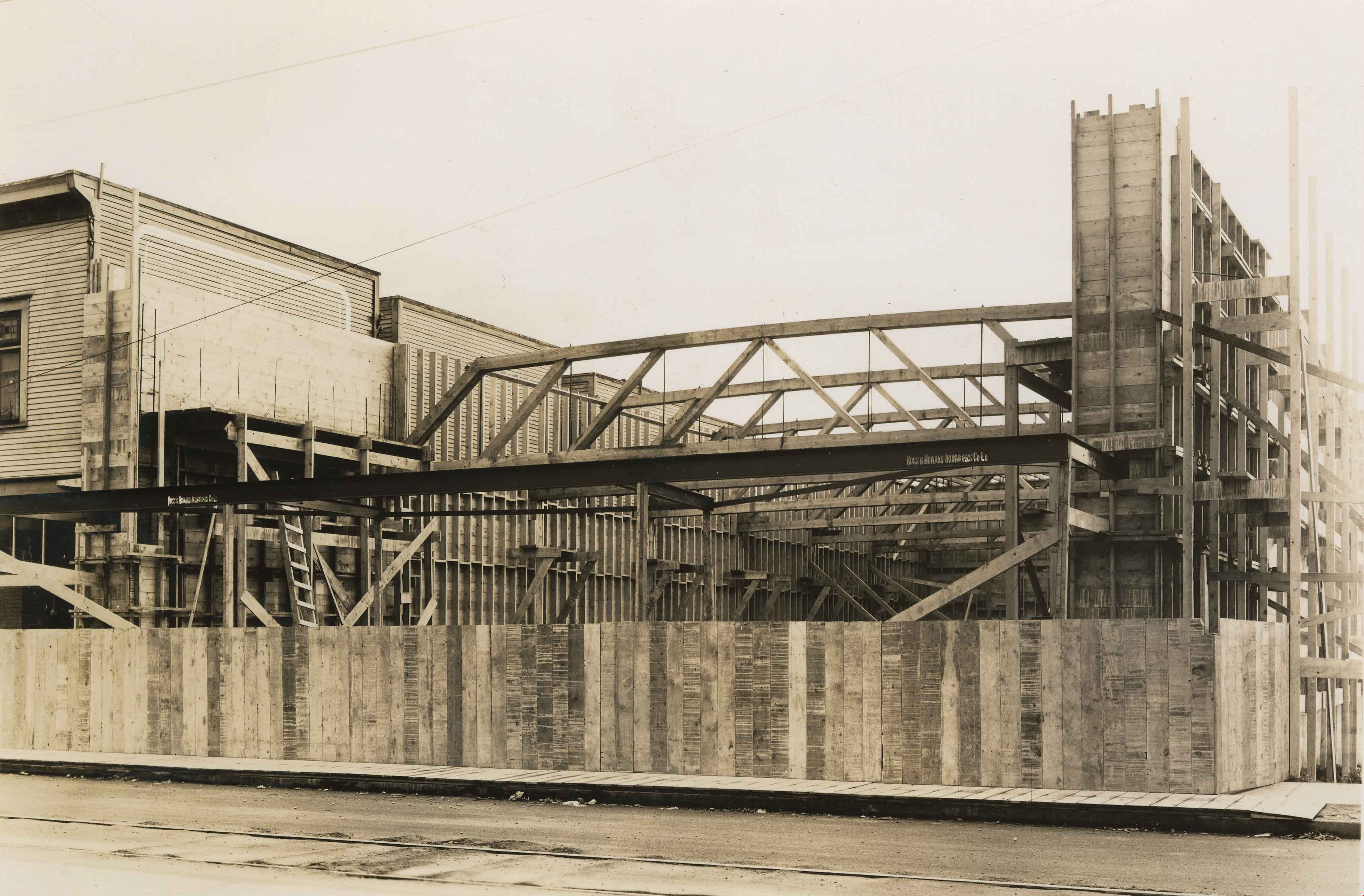
- Photograph of the construction of the Safeway building at Hastings and Gilmore.
- Repository
- City of Burnaby Archives
- Date
- 1941
- Collection/Fonds
- Burnaby Historical Society fonds
- Subseries
- North Burnaby Board of Trade subseries
- Physical Description
- 1 photograph : b&w ; 11.5 x 17 cm
- Description Level
- Item
- Record No.
- 476-023
- Access Restriction
- No restrictions
- Reproduction Restriction
- No known restrictions
- Accession Number
- BHS2005-8
- Scope and Content
- Photograph of the construction of the Safeway building at Hastings and Gilmore.
- Names
- Safeway
- Media Type
- Photograph
- Photographer
- Pinkerton, Gordon
- Notes
- Title based on contents of photograph
- Geographic Access
- Hastings Street
- Gilmore Avenue
- Historic Neighbourhood
- Vancouver Heights (Historic Neighbourhood)
- Planning Study Area
- Burnaby Heights Area
Images
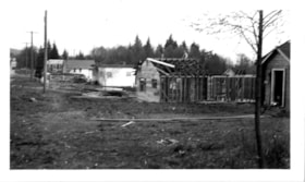
Site of Martin's Auto Villa at 6604 Hastings Street East
https://search.heritageburnaby.ca/link/museumdescription15045
- Repository
- Burnaby Village Museum
- Date
- 24 Sep. 1945
- Collection/Fonds
- Elmer Wilson Martin fonds
- Description Level
- Item
- Physical Description
- 1 photograph : b&w ; 7 x 11.5 cm
- Scope and Content
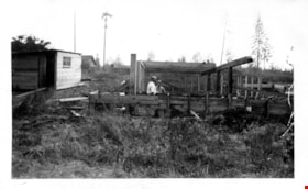
- Photograph of two men standing on the building site for E.W. Martin's Auto Villa. The men are standing in the wooden framework of the building "Martin's Auto Villa" located in District Lot 206, 6604 Hastings Street (after 1950 - 6574 East Hastings Street). The wood framework is surrounded by tall g…
- Repository
- Burnaby Village Museum
- Collection/Fonds
- Elmer Wilson Martin fonds
- Description Level
- Item
- Physical Description
- 1 photograph : b&w ; 7 x 11.5 cm
- Scope and Content
- Photograph of two men standing on the building site for E.W. Martin's Auto Villa. The men are standing in the wooden framework of the building "Martin's Auto Villa" located in District Lot 206, 6604 Hastings Street (after 1950 - 6574 East Hastings Street). The wood framework is surrounded by tall grass and debris.
- Subjects
- Construction
- Names
- Martin's Auto Villa
- Geographic Access
- Hastings Street
- Street Address
- 6574 Hastings Street
- Accession Code
- BV019.37.20
- Access Restriction
- No restrictions
- Reproduction Restriction
- No known restrictions
- Date
- 24 Sep. 1945
- Media Type
- Photograph
- Planning Study Area
- Lochdale Area
- Scan Resolution
- 600
- Scan Date
- February 4, 2021
- Scale
- 100
- Notes
- Title based on contents of photograph
- See also BV019.37.16
- Note in blue ink on verso of photograph reads: Sept. 24th 1945 / Dane Ramage [sic] & Bert / 6604 Hastings St. E."
Images
![Standing in front of Harry's confectionery store, [between 1944 and 1948] thumbnail](/media/hpo/_Data/_BVM_Images/2000/200500200012.jpg?width=280)
Standing in front of Harry's confectionery store
https://search.heritageburnaby.ca/link/museumdescription1886
- Repository
- Burnaby Village Museum
- Date
- [between 1944 and 1948]
- Collection/Fonds
- Harry Royle fonds
- Description Level
- Item
- Physical Description
- 1 photograph : b&w ; 8 x 5 cm
- Scope and Content
- Photograph of men, women and children sitting and standing in three rows in front of Harry's confectionery store. Some of the men are in military uniforms. Harry Royle opened this store in 1925 and it quickly became a popular meeting spot for young people. Two of the men are dressed in military uni…
- Repository
- Burnaby Village Museum
- Collection/Fonds
- Harry Royle fonds
- Description Level
- Item
- Physical Description
- 1 photograph : b&w ; 8 x 5 cm
- Scope and Content
- Photograph of men, women and children sitting and standing in three rows in front of Harry's confectionery store. Some of the men are in military uniforms. Harry Royle opened this store in 1925 and it quickly became a popular meeting spot for young people. Two of the men are dressed in military uniforms.
- Subjects
- Clothing - Uniforms
- Names
- Harry's
- Geographic Access
- Hastings Street
- Street Address
- 5527 Hastings Street
- Accession Code
- BV005.20.12
- Access Restriction
- No restrictions
- Reproduction Restriction
- No known restrictions
- Date
- [between 1944 and 1948]
- Media Type
- Photograph
- Historic Neighbourhood
- Capitol Hill (Historic Neighbourhood)
- Planning Study Area
- Capitol Hill Area
- Scan Resolution
- 600
- Scan Date
- 1/12/2010
- Scale
- 100
- Notes
- Title based on contents of photograph
- Note in pencil on verso of photograph reads: "Hastings + Holdom/ North Side"
- Note the awning and the store sign, "HARRY'S" in between two large "Orange Crush" advertisement signs
Images
![Standing in front of Harry's confectionery store, [between 1944 and 1948] thumbnail](/media/hpo/_Data/_BVM_Images/2000/200500200012.jpg)
![Survey and Subdivision plans in New Westminster District Group 1 – Burnaby
, [1908] thumbnail](/media/hpo/_Data/_BVM_Cartographic_Material/1977/1977_0093_0004a_001.jpg?width=280)
Survey and Subdivision plans in New Westminster District Group 1 – Burnaby
https://search.heritageburnaby.ca/link/museumdescription6973
- Repository
- Burnaby Village Museum
- Date
- [1908]
- Collection/Fonds
- Burnaby Village Museum Map collection
- Description Level
- File
- Physical Description
- 10 plans : blueprint ink on paper mounted on 2 sides of cardboard ; 76 cm x 102 cm
- Scope and Content
- Item consists of a large board of four New Westminster District Gp 1 - subdivision plans mounted on one side and six New Westminster District Gp 1 - subdivision plans mounted on the other side. Side A: 1. Blueprint "Plan / of - ReSubdivision / of / Lots 1-18 inclusive / Blocks 20 and 21 / in Sub…
- Repository
- Burnaby Village Museum
- Collection/Fonds
- Burnaby Village Museum Map collection
- Description Level
- File
- Physical Description
- 10 plans : blueprint ink on paper mounted on 2 sides of cardboard ; 76 cm x 102 cm
- Material Details
- Scales [between 1:792 and 1:4752]
- Index number on edge of board reads: "4"
- Scope and Content
- Item consists of a large board of four New Westminster District Gp 1 - subdivision plans mounted on one side and six New Westminster District Gp 1 - subdivision plans mounted on the other side. Side A: 1. Blueprint "Plan / of - ReSubdivision / of / Lots 1-18 inclusive / Blocks 20 and 21 / in Subdivision / of / Lot 53 -Gr.1 / New Westminster District" / "Subdivision Lot Numbers - Shown in Red". Plan is bordered by First Street / Jorgenson's Line / Fourth Avenue and Second Street with Fifith Avenue running through the centre. There is an index in the upper right corner of the plan. Planned is signed by "Peter Byrne" and "William R. Phillips" and dated July 28, 1908. (Geographic location: Burnaby) 2. Blueprint "Plan / of Subdivision / of / Lot 159 / and a Portion of Lot 158 / Group One / New Westminster District". Plan is bordered by Lots 96 and 97; South Wilson Street; North Arm Road and Lot 160 / Power House Road (Lot 155 A). B.C.E.R. Gilley Station is identified in the upper right corner of the plan. (Geographic location: Burnaby) 3. Blueprint plan identified as "Subdvs 10, L 88 and Lot 25, G. 1" Plan identifies Cumberland Street running from top to the bottom and a Ravine running alongside with the Jensen house, stable and barn. (Geographic location: Burnaby) 4. Blueprint Plan of "Lot 153. G. 1 /New Westminster District". Plan identifies the "New Westminster & Vancouver Tramway" and the "New Westminster and Vancouver Road" running through the plan of Lot 53. (Geographic location: Burnaby) Side B: 1. Blueprint plan of "Profile on Proposed North Rd. Diversion". 2. Blueprint plan (no title) showing wood lots north of Burnaby Lake and Brunette River and west of North Road. Various lots are identified as "Heavily Timbered" (Lot 57); "Splendid Fir and Cedar / Heavy Fir etc. / Fine Cedar" (Lots 143, 148); "Rough Light Timber," (Lot 56); "Some Fir and Cedar" (Lot 40). (Geographic location: Burnaby) 3. Blueprint "Plan / of Subdivision / of a Portion / of Lot 87, Gr.1 / New Westminster District". Plan is bordered by Burnaby Lake at the top and Hastings Road / Lot 86 at the bottom and Lot 90 to the east. "Albert J. Hill B.C.LotS." Annotation in ink reads: " J.A. Brownlee, B.C.L.S. / Subdivision / Map 1494 / Bd. 248". Plan is signed by "Peter Byrne, Reeve" (Geographic location: Burnaby) 4. Blueprint plan of Subdivisions along either side of Douglas Road including Lots 117; 119; 74; 80; 79 and 77. (Geographic location: Burnaby) 5. Blueprint "Plan / of / Subdivision of / Lot 27 / in Subdivision / of / Lot 30 / Group One / New Westminster District" Plan is bordered by Lot 26, Lot 28 and Hastings Rd. Lot 27 runs north of Edmonds Street. , "Albert J. Hill, B.C.LotS." (Geographic location: Burnaby) 6. Blueprint plan identified as a "Cultivated Orchard" including the names "W. Grace" and "G. Mead" located north of the North Arm Fraser River and west of "Twentieth Street_ City Boundary". Handwritten annotation in coloured pencil reads: "Portion of Lot 172" (Geographic location: Burnaby)
- Subjects
- Geographic Features - Forests
- Geographic Access
- Cumberland Street
- North Road
- Hastings Street
- Douglas Road
- Accession Code
- HV977.93.4
- Access Restriction
- No restrictions
- Reproduction Restriction
- No known restrictions
- Date
- [1908]
- Media Type
- Cartographic Material
- Historic Neighbourhood
- Burnaby Lake (Historic Neighbourhood)
- Fraser Arm (Historic Neighbourhood)
- Planning Study Area
- Douglas-Gilpin Area
- Burnaby Lake Area
- Scan Resolution
- 300
- Scale
- 72
- Notes
- Title based on contents of file
- Scale is measured in chains. (One chain equals 792 inches)
- The term "Lot" can also refer to a "District Lot”-
Images
![Survey and Subdivision plans in New Westminster District Group 1 – Burnaby
, [1908] thumbnail](/media/hpo/_Data/_BVM_Cartographic_Material/1977/1977_0093_0004a_001.jpg)

![Willingdon Avenue and Hastings Street Intersection, [1943 or 1944] (date of original), copied 1991 thumbnail](/media/hpo/_Data/_Archives_Images/_Unrestricted/370/370-230.jpg?width=280)
Willingdon Avenue and Hastings Street Intersection
https://search.heritageburnaby.ca/link/archivedescription37642
- Repository
- City of Burnaby Archives
- Date
- [1943 or 1944] (date of original), copied 1991
- Collection/Fonds
- Burnaby Historical Society fonds
- Description Level
- Item
- Physical Description
- 1 photograph : b&w ; 3.2 x 5.3 cm print on contact sheet 20.2 x 25.3 cm
- Scope and Content
- Photograph of the intersection at Willingdon Avenue and Hastings Street, facing north from the southwest corner.
- Repository
- City of Burnaby Archives
- Date
- [1943 or 1944] (date of original), copied 1991
- Collection/Fonds
- Burnaby Historical Society fonds
- Subseries
- Burnaby Image Bank subseries
- Physical Description
- 1 photograph : b&w ; 3.2 x 5.3 cm print on contact sheet 20.2 x 25.3 cm
- Description Level
- Item
- Record No.
- 370-230
- Access Restriction
- No restrictions
- Reproduction Restriction
- No known restrictions
- Accession Number
- BHS1999-03
- Scope and Content
- Photograph of the intersection at Willingdon Avenue and Hastings Street, facing north from the southwest corner.
- Subjects
- Geographic Features - Roads
- Media Type
- Photograph
- Notes
- Title based on contents of photograph
- 1 b&w copy negative accompanying
- Geographic Access
- Willingdon Avenue
- Hastings Street
- Historic Neighbourhood
- Vancouver Heights (Historic Neighbourhood)
- Planning Study Area
- Burnaby Heights Area
Images
![Willingdon Avenue and Hastings Street Intersection, [1943 or 1944] (date of original), copied 1991 thumbnail](/media/hpo/_Data/_Archives_Images/_Unrestricted/370/370-230.jpg)
![The Woman's Bakery, [1948] thumbnail](/media/hpo/_Data/_Archives_Images/_Unrestricted/205/248-002.jpg?width=280)
The Woman's Bakery
https://search.heritageburnaby.ca/link/archivedescription36330
- Repository
- City of Burnaby Archives
- Date
- [1948]
- Collection/Fonds
- Burnaby Historical Society fonds
- Description Level
- Item
- Physical Description
- 1 photograph : b&w ; 6.5 x 9.5 cm
- Scope and Content
- Photograph of the Woman's Bakery on Hastings Street.
- Repository
- City of Burnaby Archives
- Date
- [1948]
- Collection/Fonds
- Burnaby Historical Society fonds
- Subseries
- Hazel L'Estrange subseries
- Physical Description
- 1 photograph : b&w ; 6.5 x 9.5 cm
- Description Level
- Item
- Record No.
- 248-002
- Access Restriction
- No restrictions
- Reproduction Restriction
- No known restrictions
- Accession Number
- BHS1991-02
- Scope and Content
- Photograph of the Woman's Bakery on Hastings Street.
- Subjects
- Buildings - Commercial - Stores
- Names
- The Woman's Bakery
- Media Type
- Photograph
- Notes
- Title based on contents of photograph
- Geographic Access
- Hastings Street
Images
![The Woman's Bakery, [1948] thumbnail](/media/hpo/_Data/_Archives_Images/_Unrestricted/205/248-002.jpg)
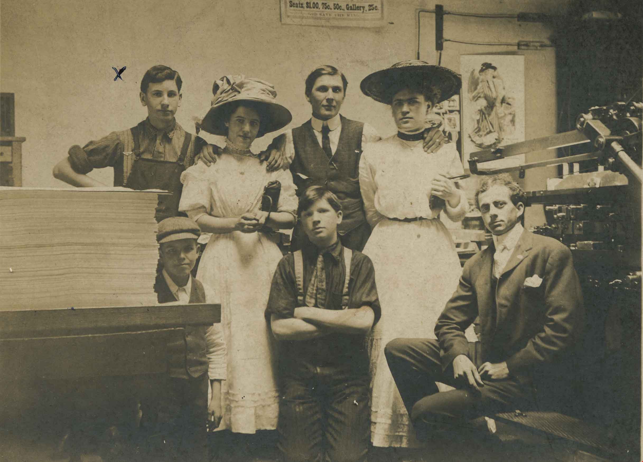
Working as a Press Feeder
https://search.heritageburnaby.ca/link/archivedescription36152
- Repository
- City of Burnaby Archives
- Date
- 1908
- Collection/Fonds
- Burnaby Historical Society fonds
- Description Level
- Item
- Physical Description
- 1 photograph : b&w ; 7.5 x 10 cm, mounted on board 13.5 x 16 cm
- Scope and Content
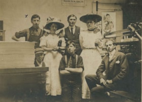
- Photograph of Mr Murdoch McMurray (far left) working as a Press Feeder, and his co-workers, at a firm believed to be on or near Hastings. The young women standing with Murdoch worked in the "Bindery".
- Repository
- City of Burnaby Archives
- Date
- 1908
- Collection/Fonds
- Burnaby Historical Society fonds
- Physical Description
- 1 photograph : b&w ; 7.5 x 10 cm, mounted on board 13.5 x 16 cm
- Description Level
- Item
- Record No.
- 229-001
- Access Restriction
- No restrictions
- Reproduction Restriction
- No known restrictions
- Accession Number
- BHS1989-22
- Scope and Content
- Photograph of Mr Murdoch McMurray (far left) working as a Press Feeder, and his co-workers, at a firm believed to be on or near Hastings. The young women standing with Murdoch worked in the "Bindery".
- Names
- McMurray, Murdoch
- Media Type
- Photograph
- Notes
- Title based on contents of photograph
- Note on verso of photograph reads: "...Mr. McMurray was making 10 dollars a week at the time."
- Geographic Access
- Hastings Street
Images