Alta Vista Baptist Church
https://search.heritageburnaby.ca/link/landmark557
- Repository
- Burnaby Heritage Planning
- Description
- Church building.
- Associated Dates
- 1936
- Other Names
- Royal Oak Community Church
- Street View URL
- Google Maps Street View
- Repository
- Burnaby Heritage Planning
- Other Names
- Royal Oak Community Church
- Geographic Access
- Royal Oak Avenue
- Associated Dates
- 1936
- Description
- Church building.
- Heritage Value
- This Baptist congregation originally held services in a tent at the corner of McGregor Avenue and Portland but they soon were able to build a small church. A membership drive by Pastor Arthur James Bowbrick (1875-1961) was so successful that the congregation was able build this fine structure, prominently located at the corner of Victory Street. Although it has been altered with later additions and stucco over the original siding, the original windows and the rooftop belfry remain.
- Locality
- Alta Vista
- Historic Neighbourhood
- Alta Vista (Historic Neighbourhood)
- Planning Study Area
- Sussex-Nelson Area
- Ownership
- Private
- Street Address
- 7175 Royal Oak Avenue
- Street View URL
- Google Maps Street View
Images


Alta Vista Neighbourhood
https://search.heritageburnaby.ca/link/landmark707
- Repository
- Burnaby Heritage Planning
- Associated Dates
- 1925-1954
- Heritage Value
- As with many areas of Burnaby during this period, the years after World War Two marked a rapid growth in residential development in the Alta-Vista Neighbourhood. Subdivisions like Sussex and Suncrest were built and new schools and amenities were constructed to meet the demands of increased population.
- Historic Neighbourhood
- Alta Vista (Historic Neighbourhood)
- Planning Study Area
- Sussex-Nelson Area
Images


Alta Vista Neighbourhood
https://search.heritageburnaby.ca/link/landmark766
- Repository
- Burnaby Heritage Planning
- Associated Dates
- 1905-1924
- Heritage Value
- Alta Vista, named for its high views of the Fraser Valley, rapidly grew during the period 1910-1912, seeing its settlement jump from about a dozen buildings in 1910 to about four hundred by the end of 1912. Home-seekers were attracted to its location just a short walk from the B.C.E.R. line at Royal Oak and Highland Park and easily accessible to both New Westminster and Vancouver.
- Historic Neighbourhood
- Alta Vista (Historic Neighbourhood)
- Planning Study Area
- Sussex-Nelson Area
Images


Clinton School
https://search.heritageburnaby.ca/link/landmark709
- Repository
- Burnaby Heritage Planning
- Geographic Access
- Clinton Street
- Associated Dates
- 1948
- Heritage Value
- With the increasing settlement on the south slope between Kingsway and Marine Drive following World War Two, the old two-room school of Riverway East was considered inadequate so in 1948, the Clinton Elementary School opened. Clinton was to be the prototype of post-war elementary schools in Burnaby. It had no basement, no second storey and no high stairways. Classrooms were built in line and easily added as needed. Clinton had additions in 1950, 1951, 1957, 1964, 1965, 1967 and 1973.
- Historic Neighbourhood
- Alta Vista (Historic Neighbourhood)
- Planning Study Area
- Clinton-Glenwood Area
- Street Address
- 5858 Clinton Street
- Street View URL
- Google Maps Street View
Images


Digney Speedway
https://search.heritageburnaby.ca/link/landmark693
- Repository
- Burnaby Heritage Planning
- Geographic Access
- MacPherson Avenue
- Irmin Street
- Associated Dates
- 1948
- Heritage Value
- Andy Digney built the speedway in South Burnaby in 1948. He was approached by the B.C. Midget Auto Racing Association, who were looking for a good location to race the smaller, racing cars, popular at the time. Digney owned property in the vicinity of present-day Metrotown that was centrally located and easily accessible via the interurban railway. Motorcycles were also raced in the early days of the track. In 1949, when the popularity of midget racing declined, Digney started racing roadsters. However, he struggled to find local drivers, and it was expensive to bring in drivers from elsewhere. In 1951 Digney found a winner: jalopy racing. Local men would buy 1930s cars and strip them down, remove the glass, and weld the doors shut. By early 1952 over forty cars were showing up for jalopy races. By the early 1950s the Speedway was well established, with coverage in the sports pages and on radio. The track closed down in 1958 when Andy retired.
- Historic Neighbourhood
- Alta Vista (Historic Neighbourhood)
- Planning Study Area
- Clinton-Glenwood Area
Images


Ocean View Burial Park - Chapel
https://search.heritageburnaby.ca/link/landmark628
- Repository
- Burnaby Heritage Planning
- Geographic Access
- Imperial Street
- Associated Dates
- 1936
- Description
- Church building.
- Heritage Value
- Subsequent work at Ocean View was designed by local architects Sharp & Thompson through the 1950s, including the stone-faced Garden Chapel, built in 1936 as a replica of a Norman church. Prominent stone gates also replaced the original gates at the corner entrance. George Sharp (1880-1974) and Charles Thompson (1878-1961) formed Vancouver’s longest surviving architectural firm in 1908. They were born, educated and articled in London, before arriving in Vancouver via different routes. In 1912, the firm won the competition for the new University of British Columbia.
- Locality
- Alta Vista
- Historic Neighbourhood
- Alta Vista (Historic Neighbourhood)
- Planning Study Area
- Suncrest Area
- Architect
- Sharp & Thompson
- Area
- 359280.00
- Contributing Resource
- Building
- Ownership
- Private
- Street Address
- 4000 Imperial Street
Images


O.G. Naud House
https://search.heritageburnaby.ca/link/landmark509
- Repository
- Burnaby Heritage Planning
- Description
- The O.G. Naud House is a south facing, two-storey house with a bellcast hipped roof, set on a high basement. It features a double-height front verandah supported by classical columns. It is located on Victory Street in the Alta Vista neighbourhood of South Burnaby, and is one of the oldest houses i…
- Associated Dates
- 1908
- Formal Recognition
- Heritage Designation, Community Heritage Register
- Other Names
- Onezime & Charlsie Naud House
- Street View URL
- Google Maps Street View
- Repository
- Burnaby Heritage Planning
- Other Names
- Onezime & Charlsie Naud House
- Geographic Access
- Victory Street
- Associated Dates
- 1908
- Formal Recognition
- Heritage Designation, Community Heritage Register
- Enactment Type
- By-law No. 12316
- Enactment Date
- 26/05/2008
- Description
- The O.G. Naud House is a south facing, two-storey house with a bellcast hipped roof, set on a high basement. It features a double-height front verandah supported by classical columns. It is located on Victory Street in the Alta Vista neighbourhood of South Burnaby, and is one of the oldest houses in the area.
- Heritage Value
- Built in 1908, the O.G. Naud House is valued as one of the first houses to be built in the Alta Vista neighbourhood and is a direct link to the first settlement of the area. Close proximity to the B.C. Electric Railway streetcar line, at Royal Oak and Highland Park, permitted easy access to New Westminster and Vancouver. These transportation links, combined with spectacular views of the Fraser Valley, encouraged the early development of this South Burnaby neighbourhood. The O.G. Naud House is architecturally significant as an example of the influence of the Classical Revival style that had been popularized in Eastern Canada. The basic form of the house is a Foursquare, with a double-height verandah that dominates the symmetrically balanced façade, supported on lathe-turned columns. A central entry and regular fenestration further unify the façade composition. Construction employed locally available materials. The rough-cut foundation stone was harvested from boulders from the G. Ledingham property on the south side of Victory Street. The builder and first owner, Onezime George Naud (1858-1951), was originally from St. Albans, Quebec. He worked on railway construction in Alabama, where he met his wife, Charlsie Elizabeth Sims (1869-1974). He later took part in the 1898 Gold Rush in Atlin, then worked as a stonemason on CPR culverts and bridges across B.C. An accomplished stonemason, Naud also worked on the original Vancouver and New Westminster post offices, the Parliament buildings in Victoria, and the Capitol building in Olympia, Washington.
- Defining Elements
- The key characteristics that define the heritage character of the O.G. Naud House include its: - south-facing location, with generous set back from the street, in the Alta Vista neighbourhood of South Burnaby - residential form, scale and massing as expressed by its two-storey height plus full basement, bellcast hipped roof, rectangular plan and front projecting double-height verandah - masonry construction materials such as the rough-cut granite foundation - wood-frame construction, including lapped wooden siding and shingle siding extant under later cladding - Edwardian era features including lathe-turned columns, balustrades of dimensional lumber, scroll-cut bargeboards in front gable, and scroll-cut eave brackets - associated landscape features including lane access to the east, large cedar trees and perimeter plantings
- Historic Neighbourhood
- Alta Vista (Historic Neighbourhood)
- Planning Study Area
- Sussex-Nelson Area
- Function
- Primary Historic--Single Dwelling
- Community
- Alta Vista
- Cadastral Identifier
- P.I.D.003-100-375
- Boundaries
- The O.G. Naud House is comprised of a single residential lot located at 4737 Victory Street, Burnaby.
- Area
- 1099.47
- Contributing Resource
- Building
- Ownership
- Private
- Documentation
- City of Burnaby Planning and Building Department, Heritage Site Files
- Street Address
- 4737 Victory Street
- Street View URL
- Google Maps Street View
Images


Richard & Alice Dunn Residence
https://search.heritageburnaby.ca/link/landmark552
- Repository
- Burnaby Heritage Planning
- Description
- Residential building.
- Associated Dates
- 1939
- Street View URL
- Google Maps Street View
- Repository
- Burnaby Heritage Planning
- Geographic Access
- Jubilee Avenue
- Associated Dates
- 1939
- Description
- Residential building.
- Heritage Value
- This house was built for Richard Dunn, a police sergeant with the B.C. Police force and his wife Alice. This house is a notable example of a Storybook Cottage, dating from just prior to the outbreak of the Second World War. Modest houses of the era often assumed a cottage appearance that provided a romantic ideal of traditional domesticity. With its smooth, planar stucco, severely-clipped roof edges, round-arched door and windows, side arch with a catslide roof, cross-leaded glass and brick detailing, this house is an excellent example of this picturesque housing trend. Located on a corner lot, the house was sited at an angle. The large Chilean Pine, or monkey-puzzle tree, entrance is a remarkable specimen.
- Locality
- Alta Vista
- Historic Neighbourhood
- Alta Vista (Historic Neighbourhood)
- Planning Study Area
- Sussex-Nelson Area
- Ownership
- Private
- Street Address
- 7207 Jubilee Avenue
- Street View URL
- Google Maps Street View
Images


Vincent & Edna Dodd Residence
https://search.heritageburnaby.ca/link/landmark650
- Repository
- Burnaby Heritage Planning
- Description
- Residential building.
- Associated Dates
- 1941
- Street View URL
- Google Maps Street View
- Repository
- Burnaby Heritage Planning
- Geographic Access
- Clinton Street
- Associated Dates
- 1941
- Description
- Residential building.
- Heritage Value
- Designed to simulate a Norman cottage, the most distinctive feature of this eclectic bungalow is its round entrance tower with a conical shaped roof. Other distinctive features include rolled roof edges clad with steam-bent shingles to resemble a thatched roof, and round-arched windows surrounded with initiation voussoirs. The traditional character reflects the Storybook Cottage movement popular in the years between the two World Wars. It was built for Vincent Esmond Dodd (1913-1985), a plumber and electrician, and his wife Edna Mary Dodd (née Engeseth). Edna continued to live in the house after Vincent’s death in 1985.
- Locality
- Alta Vista
- Historic Neighbourhood
- Alta Vista (Historic Neighbourhood)
- Planning Study Area
- Clinton-Glenwood Area
- Area
- 613.16
- Contributing Resource
- Building
- Ownership
- Private
- Street Address
- 6270 Clinton Street
- Street View URL
- Google Maps Street View
Images


![Anne Le Grove and Lulu, [1947] (date of original), copied 1991 thumbnail](/media/hpo/_Data/_Archives_Images/_Unrestricted/370/370-609.jpg?width=280)
Anne Le Grove and Lulu
https://search.heritageburnaby.ca/link/archivedescription38022
- Repository
- City of Burnaby Archives
- Date
- [1947] (date of original), copied 1991
- Collection/Fonds
- Burnaby Historical Society fonds
- Description Level
- Item
- Physical Description
- 1 photograph : b&w ; 2.8 x 4.2 cm print on contact sheet 20.6 x 26.9 cm
- Scope and Content
- Photograph of Anne Le Grove and her dog Lulu, seated in chairs outside at 2115 Waverley Avenue (later renumbered 7116 Waverley Avenue).
- Repository
- City of Burnaby Archives
- Date
- [1947] (date of original), copied 1991
- Collection/Fonds
- Burnaby Historical Society fonds
- Subseries
- Burnaby Image Bank subseries
- Physical Description
- 1 photograph : b&w ; 2.8 x 4.2 cm print on contact sheet 20.6 x 26.9 cm
- Description Level
- Item
- Record No.
- 370-609
- Access Restriction
- No restrictions
- Reproduction Restriction
- No known restrictions
- Accession Number
- BHS1999-03
- Scope and Content
- Photograph of Anne Le Grove and her dog Lulu, seated in chairs outside at 2115 Waverley Avenue (later renumbered 7116 Waverley Avenue).
- Subjects
- Animals - Dogs
- Furniture
- Names
- Le Grove, Anne
- Media Type
- Photograph
- Notes
- Title based on contents of photograph
- 1 b&w copy negative accompanying
- Negative has a pink cast
- Geographic Access
- Waverley Avenue
- Street Address
- 7116 Waverley Avenue
- Historic Neighbourhood
- Alta-Vista (Historic Neighbourhood)
- Planning Study Area
- Sussex-Nelson Area
Images
![Anne Le Grove and Lulu, [1947] (date of original), copied 1991 thumbnail](/media/hpo/_Data/_Archives_Images/_Unrestricted/370/370-609.jpg)
![Bea Hardy, [1934] (date of original), copied 1991 thumbnail](/media/hpo/_Data/_Archives_Images/_Unrestricted/370/370-648.jpg?width=280)
Bea Hardy
https://search.heritageburnaby.ca/link/archivedescription38061
- Repository
- City of Burnaby Archives
- Date
- [1934] (date of original), copied 1991
- Collection/Fonds
- Burnaby Historical Society fonds
- Description Level
- Item
- Physical Description
- 1 photograph : b&w ; 4.3 x 2.9 cm print on contact sheet 20.4 x 26.5 cm
- Scope and Content
- Photograph of Bea Hardy standing at the back of 2930 McKee Street (later renumbered 5850 McKee Street).
- Repository
- City of Burnaby Archives
- Date
- [1934] (date of original), copied 1991
- Collection/Fonds
- Burnaby Historical Society fonds
- Subseries
- Burnaby Image Bank subseries
- Physical Description
- 1 photograph : b&w ; 4.3 x 2.9 cm print on contact sheet 20.4 x 26.5 cm
- Description Level
- Item
- Record No.
- 370-648
- Access Restriction
- No restrictions
- Reproduction Restriction
- No known restrictions
- Accession Number
- BHS1999-03
- Scope and Content
- Photograph of Bea Hardy standing at the back of 2930 McKee Street (later renumbered 5850 McKee Street).
- Names
- Hardy, Bea
- Media Type
- Photograph
- Notes
- Title based on contents of photograph
- 1 b&w copy negative accompanying
- Negative has a pink cast
- Geographic Access
- McKee Street
- Street Address
- 5850 McKee Street
- Historic Neighbourhood
- Alta-Vista (Historic Neighbourhood)
- Planning Study Area
- Clinton-Glenwood Area
Images
![Bea Hardy, [1934] (date of original), copied 1991 thumbnail](/media/hpo/_Data/_Archives_Images/_Unrestricted/370/370-648.jpg)
Bezanson brothers
https://search.heritageburnaby.ca/link/archivedescription35855
- Repository
- City of Burnaby Archives
- Date
- 1932
- Collection/Fonds
- Burnaby Historical Society fonds
- Description Level
- Item
- Physical Description
- 1 photograph : b&w ; 12.7 x 17.8 cm print
- Scope and Content
- Photograph of the Bezanson brothers, Charlie and Albert. The boys are shown with a homemade bobsled used to careen down Royal Oak Road hill past Oakalla.
- Repository
- City of Burnaby Archives
- Date
- 1932
- Collection/Fonds
- Burnaby Historical Society fonds
- Subseries
- Pioneer Tales subseries
- Physical Description
- 1 photograph : b&w ; 12.7 x 17.8 cm print
- Description Level
- Item
- Record No.
- 204-714
- Access Restriction
- No restrictions
- Reproduction Restriction
- No known restrictions
- Accession Number
- BHS1988-03
- Scope and Content
- Photograph of the Bezanson brothers, Charlie and Albert. The boys are shown with a homemade bobsled used to careen down Royal Oak Road hill past Oakalla.
- Media Type
- Photograph
- Notes
- Title based on contents of photograph
- Geographic Access
- Royal Oak Avenue
- Street Address
- 7883 Royal Oak Avenue
- Historic Neighbourhood
- Alta-Vista (Historic Neighbourhood)
- Planning Study Area
- Clinton-Glenwood Area
Images

![Bickerton family home, [194-?] (date of original), copied 1992 thumbnail](/media/hpo/_Data/_Archives_Images/_Unrestricted/315/315-258.jpg?width=280)
Bickerton family home
https://search.heritageburnaby.ca/link/archivedescription36801
- Repository
- City of Burnaby Archives
- Date
- [194-?] (date of original), copied 1992
- Collection/Fonds
- Burnaby Historical Society fonds
- Description Level
- Item
- Physical Description
- 1 photograph : b&w ; 8.9 x 12.7 cm print
- Scope and Content
- Photograph of the Bickerton family home at 2125 Nelson Avenue (later renumbered 7082 Nelson Avenue) near Victory Street, built in 1905.
- Repository
- City of Burnaby Archives
- Date
- [194-?] (date of original), copied 1992
- Collection/Fonds
- Burnaby Historical Society fonds
- Subseries
- Burnaby Centennial Anthology subseries
- Physical Description
- 1 photograph : b&w ; 8.9 x 12.7 cm print
- Description Level
- Item
- Record No.
- 315-258
- Access Restriction
- No restrictions
- Reproduction Restriction
- Reproduce for fair dealing purposes only
- Accession Number
- BHS1994-04
- Scope and Content
- Photograph of the Bickerton family home at 2125 Nelson Avenue (later renumbered 7082 Nelson Avenue) near Victory Street, built in 1905.
- Subjects
- Buildings - Residential - Houses
- Media Type
- Photograph
- Notes
- Title based on contents of photograph
- Geographic Access
- Nelson Avenue
- Street Address
- 7082 Nelson Avenue
- Historic Neighbourhood
- Alta-Vista (Historic Neighbourhood)
- Planning Study Area
- Sussex-Nelson Area
Images
![Bickerton family home, [194-?] (date of original), copied 1992 thumbnail](/media/hpo/_Data/_Archives_Images/_Unrestricted/315/315-258.jpg)
![Bill Speirs, [1930] (date of original), copied 1986 thumbnail](/media/hpo/_Data/_Archives_Images/_Unrestricted/204/204-180.jpg?width=280)
Bill Speirs
https://search.heritageburnaby.ca/link/archivedescription35323
- Repository
- City of Burnaby Archives
- Date
- [1930] (date of original), copied 1986
- Collection/Fonds
- Burnaby Historical Society fonds
- Description Level
- Item
- Physical Description
- 1 photograph : b&w ; 12.7 x 17.8 cm print
- Scope and Content
- Photograph of Bill Speirs, leaning against the back of an automobile in front of the Speirs family home on Watling Street (near Frederick Avenue). Bill and his wife, Dell Speirs, moved to Burnaby in 1929.
- Repository
- City of Burnaby Archives
- Date
- [1930] (date of original), copied 1986
- Collection/Fonds
- Burnaby Historical Society fonds
- Subseries
- Pioneer Tales subseries
- Physical Description
- 1 photograph : b&w ; 12.7 x 17.8 cm print
- Description Level
- Item
- Record No.
- 204-180
- Access Restriction
- No restrictions
- Reproduction Restriction
- No known restrictions
- Accession Number
- BHS1988-03
- Scope and Content
- Photograph of Bill Speirs, leaning against the back of an automobile in front of the Speirs family home on Watling Street (near Frederick Avenue). Bill and his wife, Dell Speirs, moved to Burnaby in 1929.
- Names
- Speirs, Bill
- Media Type
- Photograph
- Notes
- Title based on contents of photograph
- Geographic Access
- Watling Street
- Historic Neighbourhood
- Alta-Vista (Historic Neighbourhood)
- Planning Study Area
- Sussex-Nelson Area
Images
![Bill Speirs, [1930] (date of original), copied 1986 thumbnail](/media/hpo/_Data/_Archives_Images/_Unrestricted/204/204-180.jpg)
![Building and opening the Digney Speedway, [between 1948 and 1949] thumbnail](/media/Hpo/_Data/_Archives_Moving_Images/_Unrestricted/562-003-16.jpg?width=280)
Building and opening the Digney Speedway
https://search.heritageburnaby.ca/link/archivedescription85334
- Repository
- City of Burnaby Archives
- Date
- [between 1948 and 1949]
- Collection/Fonds
- Digney Family fonds
- Description Level
- Item
- Physical Description
- 1 film clip (10 min., 47sec.) : digital, b&w, col., si.
- Scope and Content
- Item is a digitized silent film segment identified as Reel 16. The film footage shows land being cleared to make way for the Digney Speedway located near the corner of Irmin Street and MacPherson Avenue, one of the men seen in this footage clearing the land is named Lucky Fordham. The film continue…
- Repository
- City of Burnaby Archives
- Date
- [between 1948 and 1949]
- Collection/Fonds
- Digney Family fonds
- Physical Description
- 1 film clip (10 min., 47sec.) : digital, b&w, col., si.
- Description Level
- Item
- Record No.
- 562-003-16
- Access Restriction
- No restrictions
- Reproduction Restriction
- May be restricted by third party rights
- Accession Number
- 2014-04
- Scope and Content
- Item is a digitized silent film segment identified as Reel 16. The film footage shows land being cleared to make way for the Digney Speedway located near the corner of Irmin Street and MacPherson Avenue, one of the men seen in this footage clearing the land is named Lucky Fordham. The film continues with footage of a press dinner in the garden of Andy Digney's home on Bonsor Avenue in Burnaby and is followed with footage of the Digney Speedway in operation for the grand opening on July 8, 1948. Midget cars and jalopies (stock cars) can be seen racing on the speedway. Some of the footage of the raceway pit and races switches to black and white.The film closes with colour footage of a truck moving Lucky Fordham's house from Bonsor Ave to the speedway.
- Subjects
- Sports - Automobile Racing
- Media Type
- Moving Images
- Photographer
- Digney, Andy
- Creator
- Digney, Andy
- Notes
- Title based on contents of film
- Geographic Access
- Bonsor Avenue
- Historic Neighbourhood
- Alta-Vista (Historic Neighbourhood)
- Central Park (Historic Neighbourhood)
- Planning Study Area
- Clinton-Glenwood Area
- Maywood Area
Images
![Building and opening the Digney Speedway, [between 1948 and 1949] thumbnail](/media/Hpo/_Data/_Archives_Moving_Images/_Unrestricted/562-003-16.jpg)
Video
Building and opening the Digney Speedway, [between 1948 and 1949]
Building and opening the Digney Speedway, [between 1948 and 1949]
https://search.heritageburnaby.ca/media/hpo/_Data/_Archives_Moving_Images/_Unrestricted/562-003-16.m4v![Burnaby and Digney recreational events, [between 1934 and 1938] thumbnail](/media/Hpo/_Data/_Archives_Moving_Images/_Unrestricted/562-003-3.jpg?width=280)
Burnaby and Digney recreational events
https://search.heritageburnaby.ca/link/archivedescription85208
- Repository
- City of Burnaby Archives
- Date
- [between 1934 and 1938]
- Collection/Fonds
- Digney Family fonds
- Description Level
- Item
- Physical Description
- 1 film clip (10 min., 30 sec.) : digital, b&w, col., si.
- Scope and Content
- Item is a silent digitized colour and black and white film segment identified as Reel 3. The film segment opens with footage of Digney family automobile travels and of Pelican Lake, Alberta where the family spent their summer, the footage switches to footage of a parade somewhere in the Rockies (B…
- Repository
- City of Burnaby Archives
- Date
- [between 1934 and 1938]
- Collection/Fonds
- Digney Family fonds
- Physical Description
- 1 film clip (10 min., 30 sec.) : digital, b&w, col., si.
- Description Level
- Item
- Record No.
- 562-003-3
- Access Restriction
- No restrictions
- Reproduction Restriction
- May be restricted by third party rights
- Accession Number
- 2014-04
- Scope and Content
- Item is a silent digitized colour and black and white film segment identified as Reel 3. The film segment opens with footage of Digney family automobile travels and of Pelican Lake, Alberta where the family spent their summer, the footage switches to footage of a parade somewhere in the Rockies (Banff) which begins in black and white and changes to colour format. This is followed by colour footage of car racing at the Digney Speedway located on 10 acres of property on MacPherson Ave. Jelopy stock car racing is seen taking place with crowds of people looking on.
- Subjects
- Sports - Swimming
- Events - Parades
- Persons - Children
- Persons - Crowds
- Sports - Automobile Racing
- Media Type
- Moving Images
- Photographer
- Digney, Andy
- Creator
- Digney, Andy
- Notes
- Title based on contents of film
- Geographic Access
- MacPherson Avenue
- Historic Neighbourhood
- Alta-Vista (Historic Neighbourhood)
- Planning Study Area
- Clinton-Glenwood Area
Images
![Burnaby and Digney recreational events, [between 1934 and 1938] thumbnail](/media/Hpo/_Data/_Archives_Moving_Images/_Unrestricted/562-003-3.jpg)
Video
Burnaby and Digney recreational events, [between 1934 and 1938]
Burnaby and Digney recreational events, [between 1934 and 1938]
https://search.heritageburnaby.ca/media/hpo/_Data/_Archives_Moving_Images/_Unrestricted/562-003-3.m4v![England family home on Royal Oak Avenue, [between 1927 and 1930] (date of original) , copied 2020 thumbnail](/media/hpo/_Data/_BVM_Images/2020/2020_0009_0002_001.jpg?width=280)
England family home on Royal Oak Avenue
https://search.heritageburnaby.ca/link/museumdescription12230
- Repository
- Burnaby Village Museum
- Date
- [between 1927 and 1930] (date of original) , copied 2020
- Collection/Fonds
- Mary England fonds
- Description Level
- Item
- Physical Description
- 1 photograph (tiff) : b&w ; 600 dpi
- Scope and Content
- Photograph of a Craftsman style house located at 1906 Royal Oak Avenue near Victory Street in Burnaby (address was changed to 7353 Royal Oak Aveue after 1958). The house was built in 1914 and was the home of Alfred Henry and Mary England (nee Gooding). Alfred H. England died suddenly in 1917. Mary…
- Repository
- Burnaby Village Museum
- Collection/Fonds
- Mary England fonds
- Description Level
- Item
- Physical Description
- 1 photograph (tiff) : b&w ; 600 dpi
- Scope and Content
- Photograph of a Craftsman style house located at 1906 Royal Oak Avenue near Victory Street in Burnaby (address was changed to 7353 Royal Oak Aveue after 1958). The house was built in 1914 and was the home of Alfred Henry and Mary England (nee Gooding). Alfred H. England died suddenly in 1917. Mary England continued to live in the house before settling in a house that she had built on Griffiths Avenue in 1930.
- Subjects
- Buildings - Residential - Houses
- Geographic Access
- Royal Oak Avenue
- Victory Street
- Accession Code
- BV020.9.2
- Access Restriction
- No restrictions
- Reproduction Restriction
- May be restricted by third party rights
- Date
- [between 1927 and 1930] (date of original) , copied 2020
- Media Type
- Photograph
- Historic Neighbourhood
- Central Park (Historic Neighbourhood)
- Alta Vista (Historic Neighbourhood)
- Planning Study Area
- Clinton-Glenwood Area
- Scan Resolution
- 600
- Scan Date
- 12-Feb-20
- Scale
- 100
- Notes
- Title based on contents of photograph
Images
![England family home on Royal Oak Avenue, [between 1927 and 1930] (date of original) , copied 2020 thumbnail](/media/hpo/_Data/_BVM_Images/2020/2020_0009_0002_001.jpg)
![Evelyn and Lyle Le Grove, [1937] (date of original), copied 1991 thumbnail](/media/hpo/_Data/_Archives_Images/_Unrestricted/370/370-642.jpg?width=280)
Evelyn and Lyle Le Grove
https://search.heritageburnaby.ca/link/archivedescription38055
- Repository
- City of Burnaby Archives
- Date
- [1937] (date of original), copied 1991
- Collection/Fonds
- Burnaby Historical Society fonds
- Description Level
- Item
- Physical Description
- 1 photograph : b&w ; 3.9 x 2.9 cm print on contact sheet 20.4 x 26.5 cm
- Scope and Content
- Photograph of Evelyn and Lyle Le Grove at 2930 McKee Street (later renumbered 5850 McKee Street).
- Repository
- City of Burnaby Archives
- Date
- [1937] (date of original), copied 1991
- Collection/Fonds
- Burnaby Historical Society fonds
- Subseries
- Burnaby Image Bank subseries
- Physical Description
- 1 photograph : b&w ; 3.9 x 2.9 cm print on contact sheet 20.4 x 26.5 cm
- Description Level
- Item
- Record No.
- 370-642
- Access Restriction
- No restrictions
- Reproduction Restriction
- No known restrictions
- Accession Number
- BHS1999-03
- Scope and Content
- Photograph of Evelyn and Lyle Le Grove at 2930 McKee Street (later renumbered 5850 McKee Street).
- Media Type
- Photograph
- Notes
- Title based on contents of photograph
- 1 b&w copy negative accompanying
- Negative has a pink cast
- Geographic Access
- McKee Street
- Street Address
- 5850 McKee Street
- Historic Neighbourhood
- Alta-Vista (Historic Neighbourhood)
- Planning Study Area
- Clinton-Glenwood Area
Images
![Evelyn and Lyle Le Grove, [1937] (date of original), copied 1991 thumbnail](/media/hpo/_Data/_Archives_Images/_Unrestricted/370/370-642.jpg)
![Evelyn Hardy-Le Grove, Marie Hardy and Helen Hardy, [1939] (date of original), copied 1991 thumbnail](/media/hpo/_Data/_Archives_Images/_Unrestricted/370/370-647.jpg?width=280)
Evelyn Hardy-Le Grove, Marie Hardy and Helen Hardy
https://search.heritageburnaby.ca/link/archivedescription38059
- Repository
- City of Burnaby Archives
- Date
- [1939] (date of original), copied 1991
- Collection/Fonds
- Burnaby Historical Society fonds
- Description Level
- Item
- Physical Description
- 1 photograph : b&w ; 2.9 x 4.3 cm print on contact sheet 20.4 x 26.5 cm
- Scope and Content
- Photograph of mother and daughters (left to right) Evelyn Hardy Le Grove, Marie Hardy (mother) and Helen Hardy in the yard at 2930 McKee Street (later renumbered 5850 McKee Street).
- Repository
- City of Burnaby Archives
- Date
- [1939] (date of original), copied 1991
- Collection/Fonds
- Burnaby Historical Society fonds
- Subseries
- Burnaby Image Bank subseries
- Physical Description
- 1 photograph : b&w ; 2.9 x 4.3 cm print on contact sheet 20.4 x 26.5 cm
- Description Level
- Item
- Record No.
- 370-647
- Access Restriction
- No restrictions
- Reproduction Restriction
- No known restrictions
- Accession Number
- BHS1999-03
- Scope and Content
- Photograph of mother and daughters (left to right) Evelyn Hardy Le Grove, Marie Hardy (mother) and Helen Hardy in the yard at 2930 McKee Street (later renumbered 5850 McKee Street).
- Media Type
- Photograph
- Notes
- Title based on contents of photograph
- 1 b&w copy negative accompanying
- Negative has a pink cast
- Geographic Access
- McKee Street
- Street Address
- 5850 McKee Street
- Historic Neighbourhood
- Alta-Vista (Historic Neighbourhood)
- Planning Study Area
- Clinton-Glenwood Area
Images
![Evelyn Hardy-Le Grove, Marie Hardy and Helen Hardy, [1939] (date of original), copied 1991 thumbnail](/media/hpo/_Data/_Archives_Images/_Unrestricted/370/370-647.jpg)
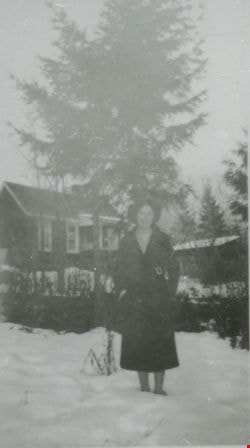
Evelyn Le Grove
https://search.heritageburnaby.ca/link/archivedescription38047
- Repository
- City of Burnaby Archives
- Date
- February 1933 (date of original), copied 1991
- Collection/Fonds
- Burnaby Historical Society fonds
- Description Level
- Item
- Physical Description
- 1 photograph : b&w ; 4.4 x 2.5 cm print on contact sheet 20.2 x 26.6 cm
- Scope and Content
- Photograph of Evelyn Le Grove at McGregor Avenue and Portland Street in the snow. A house can be seen in the background.
- Repository
- City of Burnaby Archives
- Date
- February 1933 (date of original), copied 1991
- Collection/Fonds
- Burnaby Historical Society fonds
- Subseries
- Burnaby Image Bank subseries
- Physical Description
- 1 photograph : b&w ; 4.4 x 2.5 cm print on contact sheet 20.2 x 26.6 cm
- Description Level
- Item
- Record No.
- 370-634
- Access Restriction
- No restrictions
- Reproduction Restriction
- No known restrictions
- Accession Number
- BHS1999-03
- Scope and Content
- Photograph of Evelyn Le Grove at McGregor Avenue and Portland Street in the snow. A house can be seen in the background.
- Names
- Le Grove, Evelyn Hardy
- Media Type
- Photograph
- Notes
- Title based on contents of photograph
- 1 b&w copy negative accompanying
- Negative has a pink cast
- Geographic Access
- McGregor Avenue
- Portland Street
- Historic Neighbourhood
- Alta-Vista (Historic Neighbourhood)
- Planning Study Area
- Sussex-Nelson Area
Images