Narrow Results By
Subject
- Advertising Medium - Signs and Signboards 8
- Animals - Cats 1
- Buildings - Commercial 13
- Buildings - Commercial - Automobile Dealerships 2
- Buildings - Commercial - General Stores 8
- Buildings - Commercial - Grocery Stores 8
- Buildings - Commercial - Hotels and Motels 3
- Buildings - Commercial - Restaurants 5
- Buildings - Commercial - Service Stations 15
- Buildings - Commercial - Stores 14
- Buildings - Commercial - Train Stations 13
- Buildings - Industrial - Factories 1

Interurban trams
https://search.heritageburnaby.ca/link/archivedescription35508
- Repository
- City of Burnaby Archives
- Date
- 1921 (date of original), copied 1986
- Collection/Fonds
- Burnaby Historical Society fonds
- Description Level
- Item
- Physical Description
- 1 photograph : b&w ; 12.7 x 17.8 cm print
- Scope and Content
- Photograph of Interurban trams at Central Park station. The British Columbia Electric Railway Company ran one-, two- and three-car "trains." The photograph was taken from the park, looking west toward Kingsway.
- Repository
- City of Burnaby Archives
- Date
- 1921 (date of original), copied 1986
- Collection/Fonds
- Burnaby Historical Society fonds
- Subseries
- Pioneer Tales subseries
- Physical Description
- 1 photograph : b&w ; 12.7 x 17.8 cm print
- Description Level
- Item
- Record No.
- 204-366
- Access Restriction
- No restrictions
- Reproduction Restriction
- No known restrictions
- Accession Number
- BHS1988-03
- Scope and Content
- Photograph of Interurban trams at Central Park station. The British Columbia Electric Railway Company ran one-, two- and three-car "trains." The photograph was taken from the park, looking west toward Kingsway.
- Media Type
- Photograph
- Notes
- Title based on contents of photograph
- Geographic Access
- Central Park
- Imperial Street
- Central Park Interurban line
- Street Address
- 3883 Imperial Street
- Historic Neighbourhood
- Central Park (Historic Neighbourhood)
- Planning Study Area
- Maywood Area
Images

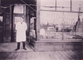
J. Pollard Meat Market
https://search.heritageburnaby.ca/link/archivedescription37357
- Repository
- City of Burnaby Archives
- Date
- 1920 (date of original), copied 1998
- Collection/Fonds
- Burnaby Historical Society fonds
- Description Level
- Item
- Physical Description
- 1 photograph : b&w ; 12.8 x 17.5 cm
- Scope and Content
- Photograph of Joseph Pollard standing outside the J. Pollard Meat Market at Kingsway and Edmonds.
- Repository
- City of Burnaby Archives
- Date
- 1920 (date of original), copied 1998
- Collection/Fonds
- Burnaby Historical Society fonds
- Subseries
- Pollard family subseries
- Physical Description
- 1 photograph : b&w ; 12.8 x 17.5 cm
- Description Level
- Item
- Record No.
- 359-003
- Access Restriction
- No restrictions
- Reproduction Restriction
- No known restrictions
- Accession Number
- BHS1998-09
- Scope and Content
- Photograph of Joseph Pollard standing outside the J. Pollard Meat Market at Kingsway and Edmonds.
- Names
- Pollard, Joseph
- Media Type
- Photograph
- Notes
- Title based on contents of photograph.
- Geographic Access
- Kingsway
- Edmonds Street
- Historic Neighbourhood
- Edmonds (Historic Neighbourhood)
- Planning Study Area
- Edmonds Area
Images

![Jubilee Avenue, [192-] (date of original), copied 1986 thumbnail](/media/hpo/_Data/_Archives_Images/_Unrestricted/126/187-002.jpg?width=280)
Jubilee Avenue
https://search.heritageburnaby.ca/link/archivedescription35069
- Repository
- City of Burnaby Archives
- Date
- [192-] (date of original), copied 1986
- Collection/Fonds
- Burnaby Historical Society fonds
- Description Level
- Item
- Physical Description
- 1 photograph : b&w ; 11.4 x 7.1 cm
- Scope and Content
- Photograph of stores on Jubilee Avenue looking north from Imperial Street (later the location of Bonsor Park, 6550 Bonsor Avenue). Signs visible read; "Jubilee Drug Store," "Drugs," "Jubilee [Mercantile?] Co. / Groceries," "Nabob Tea," and "[Carvers or Corvers]." An accompanying description in the…
- Repository
- City of Burnaby Archives
- Date
- [192-] (date of original), copied 1986
- Collection/Fonds
- Burnaby Historical Society fonds
- Subseries
- Heyworth family subseries
- Physical Description
- 1 photograph : b&w ; 11.4 x 7.1 cm
- Description Level
- Item
- Record No.
- 187-002
- Access Restriction
- No restrictions
- Reproduction Restriction
- No known restrictions
- Accession Number
- BHS1986-38
- Scope and Content
- Photograph of stores on Jubilee Avenue looking north from Imperial Street (later the location of Bonsor Park, 6550 Bonsor Avenue). Signs visible read; "Jubilee Drug Store," "Drugs," "Jubilee [Mercantile?] Co. / Groceries," "Nabob Tea," and "[Carvers or Corvers]." An accompanying description in the accession file states that a man named Pat Flannagan ran the grocery.
- Media Type
- Photograph
- Notes
- Title based on contents of photograph
- Stamp on verso of photograph reads: "5272"
- Geographic Access
- Jubilee Avenue
- Bonsor Avenue
- Street Address
- 6550 Bonsor Avenue
- Historic Neighbourhood
- Central Park (Historic Neighbourhood)
- Planning Study Area
- Marlborough Area
Images
![Jubilee Avenue, [192-] (date of original), copied 1986 thumbnail](/media/hpo/_Data/_Archives_Images/_Unrestricted/126/187-002.jpg)
![Kask's Filling Station and Store, [1927] (date of original), copied 1986 thumbnail](/media/hpo/_Data/_Archives_Images/_Unrestricted/204/204-394.jpg?width=280)
Kask's Filling Station and Store
https://search.heritageburnaby.ca/link/archivedescription35536
- Repository
- City of Burnaby Archives
- Date
- [1927] (date of original), copied 1986
- Collection/Fonds
- Burnaby Historical Society fonds
- Description Level
- Item
- Physical Description
- 1 photograph : b&w ; 12.7 x 17.8 cm print
- Scope and Content
- Photograph of Kask's Filling Station and general store on Barnet Road near Kask's Camp. Bill Kask worked here as boy and encountered fugitive felon Bill Bagley here.
- Repository
- City of Burnaby Archives
- Date
- [1927] (date of original), copied 1986
- Collection/Fonds
- Burnaby Historical Society fonds
- Subseries
- Pioneer Tales subseries
- Physical Description
- 1 photograph : b&w ; 12.7 x 17.8 cm print
- Description Level
- Item
- Record No.
- 204-394
- Access Restriction
- No restrictions
- Reproduction Restriction
- No known restrictions
- Accession Number
- BHS1988-03
- Scope and Content
- Photograph of Kask's Filling Station and general store on Barnet Road near Kask's Camp. Bill Kask worked here as boy and encountered fugitive felon Bill Bagley here.
- Media Type
- Photograph
- Notes
- Title based on contents of photograph
- Geographic Access
- Barnet Road
- Street Address
- 7501 Barnet Road
- Historic Neighbourhood
- Barnet (Historic Neighbourhood)
- Planning Study Area
- Burnaby Mountain Area
Images
![Kask's Filling Station and Store, [1927] (date of original), copied 1986 thumbnail](/media/hpo/_Data/_Archives_Images/_Unrestricted/204/204-394.jpg)
![Leeside Interurban station, [1921] (date of original), copied 1986 thumbnail](/media/hpo/_Data/_Archives_Images/_Unrestricted/204/204-544.jpg?width=280)
Leeside Interurban station
https://search.heritageburnaby.ca/link/archivedescription35686
- Repository
- City of Burnaby Archives
- Date
- [1921] (date of original), copied 1986
- Collection/Fonds
- Burnaby Historical Society fonds
- Description Level
- Item
- Physical Description
- 1 photograph : b&w ; 12.7 x 17.8 cm print
- Scope and Content
- Photograph of Leeside Interurban station on the Central Park line. Reuben Butcher (father of Violet Butcher Lynds) walked to here to catch the tram to work at B.C. Sugar in Vancouver. Lanterns used by passengers walking to and from the station during dark winter mornings and evenings were left und…
- Repository
- City of Burnaby Archives
- Date
- [1921] (date of original), copied 1986
- Collection/Fonds
- Burnaby Historical Society fonds
- Subseries
- Pioneer Tales subseries
- Physical Description
- 1 photograph : b&w ; 12.7 x 17.8 cm print
- Description Level
- Item
- Record No.
- 204-544
- Access Restriction
- No restrictions
- Reproduction Restriction
- No known restrictions
- Accession Number
- BHS1988-03
- Scope and Content
- Photograph of Leeside Interurban station on the Central Park line. Reuben Butcher (father of Violet Butcher Lynds) walked to here to catch the tram to work at B.C. Sugar in Vancouver. Lanterns used by passengers walking to and from the station during dark winter mornings and evenings were left under the wooden floor of the station.
- Media Type
- Photograph
- Notes
- Title based on contents of photograph
- Geographic Access
- Central Park Interurban line
- Historic Neighbourhood
- Edmonds (Historic Neighbourhood)
- Planning Study Area
- Stride Hill Area
Images
![Leeside Interurban station, [1921] (date of original), copied 1986 thumbnail](/media/hpo/_Data/_Archives_Images/_Unrestricted/204/204-544.jpg)
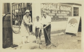
Marjorie, Fred Jr and Fred Sr
https://search.heritageburnaby.ca/link/archivedescription80157
- Repository
- City of Burnaby Archives
- Date
- 1927
- Collection/Fonds
- Montgomery family fonds
- Description Level
- Item
- Physical Description
- 1 photograph : b&w ; 7 x 12 cm
- Scope and Content
- Photograph of Marjorie Elizabeth "Marge" (Carpenter) Montgomery at Rosedale Garage with Fred Cunningham Jr and his father Fred Cunningham. The three friends are using a hose to wash off their hands.
- Repository
- City of Burnaby Archives
- Date
- 1927
- Collection/Fonds
- Montgomery family fonds
- Physical Description
- 1 photograph : b&w ; 7 x 12 cm
- Description Level
- Item
- Record No.
- 554-010
- Access Restriction
- No restrictions
- Reproduction Restriction
- No known restrictions
- Accession Number
- 2013-14
- Scope and Content
- Photograph of Marjorie Elizabeth "Marge" (Carpenter) Montgomery at Rosedale Garage with Fred Cunningham Jr and his father Fred Cunningham. The three friends are using a hose to wash off their hands.
- Media Type
- Photograph
- Notes
- Title based on contents of photograph
- Note in pencil on verso of photograph reads: "Marge on her [illegible] from Honolulu (honeymoon) / Onkie"
Images


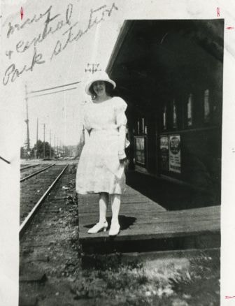
Mary Cassidy
https://search.heritageburnaby.ca/link/archivedescription35220
- Repository
- City of Burnaby Archives
- Date
- 1925 (date of original), copied 1986
- Collection/Fonds
- Burnaby Historical Society fonds
- Description Level
- Item
- Physical Description
- 1 photograph : b&w ; 12.7 x 17.8 cm print
- Scope and Content
- Photograph of Mary Cassidy at the Central Park Interurban station, located at Kingsway adjacent to Central park, on the Central Park Interurban line.
- Repository
- City of Burnaby Archives
- Date
- 1925 (date of original), copied 1986
- Collection/Fonds
- Burnaby Historical Society fonds
- Subseries
- Pioneer Tales subseries
- Physical Description
- 1 photograph : b&w ; 12.7 x 17.8 cm print
- Description Level
- Item
- Record No.
- 204-077
- Access Restriction
- No restrictions
- Reproduction Restriction
- No known restrictions
- Accession Number
- BHS1988-03
- Scope and Content
- Photograph of Mary Cassidy at the Central Park Interurban station, located at Kingsway adjacent to Central park, on the Central Park Interurban line.
- Media Type
- Photograph
- Notes
- Title based on contents of photograph
- Geographic Access
- Kingsway
- Central Park Interurban line
- Historic Neighbourhood
- Central Park (Historic Neighbourhood)
- Planning Study Area
- Maywood Area
Images
![McKay Dry Goods Store, [1927] thumbnail](/media/hpo/_Data/_Archives_Images/_Unrestricted/251/292-001.jpg?width=280)
McKay Dry Goods Store
https://search.heritageburnaby.ca/link/archivedescription36538
- Repository
- City of Burnaby Archives
- Date
- [1927]
- Collection/Fonds
- Burnaby Historical Society fonds
- Description Level
- Item
- Physical Description
- 1 photograph : b&w ; 18.5 x 24 cm (sight) in frame 32 x 37 cm
- Scope and Content
- Photograph of the Pitman's dry goods store, 3968 Kingsway Avenue (later renumbered 4600 Kingsway) at McKay Avenue. They also later operated a store on Jubilee Avenue. The McKay Avenue store ceased operations in the 1950s and the Jubilee Avenue store in 1971. (The scan has picked up glare off of the…
- Repository
- City of Burnaby Archives
- Date
- [1927]
- Collection/Fonds
- Burnaby Historical Society fonds
- Subseries
- Pitman family subseries
- Physical Description
- 1 photograph : b&w ; 18.5 x 24 cm (sight) in frame 32 x 37 cm
- Description Level
- Item
- Record No.
- 292-001
- Access Restriction
- No restrictions
- Reproduction Restriction
- No known restrictions
- Accession Number
- BHS1992-29
- Scope and Content
- Photograph of the Pitman's dry goods store, 3968 Kingsway Avenue (later renumbered 4600 Kingsway) at McKay Avenue. They also later operated a store on Jubilee Avenue. The McKay Avenue store ceased operations in the 1950s and the Jubilee Avenue store in 1971. (The scan has picked up glare off of the glass on the photograph's frame).
- Subjects
- Buildings - Commercial - Stores
- Names
- McKay Dry Goods Store
- Media Type
- Photograph
- Photographer
- Lloyd's Studio
- Notes
- Title based on contents of photograph
- Photographer's signature written in pencil on recto of mat reads: "Lloyd Studio./ McKay."
- Geographic Access
- Kingsway
- Street Address
- 4600 Kingsway
- Historic Neighbourhood
- Central Park (Historic Neighbourhood)
- Planning Study Area
- Maywood Area
Images
![McKay Dry Goods Store, [1927] thumbnail](/media/hpo/_Data/_Archives_Images/_Unrestricted/251/292-001.jpg)
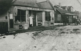
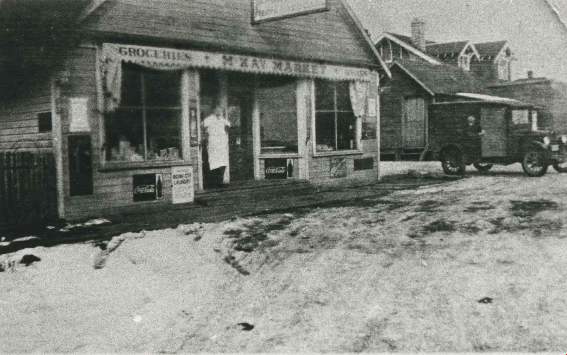
McKay Market
https://search.heritageburnaby.ca/link/archivedescription35746
- Repository
- City of Burnaby Archives
- Date
- 1926 (date of original), copied 1986
- Collection/Fonds
- Burnaby Historical Society fonds
- Description Level
- Item
- Physical Description
- 1 photograph : b&w ; 12.7 x 17.8 cm print
- Scope and Content
- Photograph of McKay Market at 2624 McKay Avenue (later renumbered 6555 McKay Avenue). Identified: (back) Ed Morash, driver of delivery truck (brother of Murial Morash Crosby); (in doorway) William Tate Wilson, store owner and later Reeve of Burnaby, 1943-44.
- Repository
- City of Burnaby Archives
- Date
- 1926 (date of original), copied 1986
- Collection/Fonds
- Burnaby Historical Society fonds
- Subseries
- Pioneer Tales subseries
- Physical Description
- 1 photograph : b&w ; 12.7 x 17.8 cm print
- Description Level
- Item
- Record No.
- 204-604
- Access Restriction
- No restrictions
- Reproduction Restriction
- No known restrictions
- Accession Number
- BHS1988-03
- Scope and Content
- Photograph of McKay Market at 2624 McKay Avenue (later renumbered 6555 McKay Avenue). Identified: (back) Ed Morash, driver of delivery truck (brother of Murial Morash Crosby); (in doorway) William Tate Wilson, store owner and later Reeve of Burnaby, 1943-44.
- Subjects
- Buildings - Commercial - Grocery Stores
- Occupations - Truck Drivers
- Occupations - Grocers
- Officials - Mayors and Reeves
- Media Type
- Photograph
- Notes
- Title based on contents of photograph
- Geographic Access
- McKay Avenue
- Street Address
- 6555 McKay Avenue
- Historic Neighbourhood
- Central Park (Historic Neighbourhood)
- Planning Study Area
- Maywood Area
Images
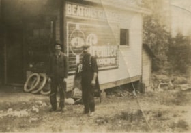
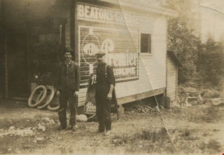
Murdoch McMurray and a co-worker
https://search.heritageburnaby.ca/link/archivedescription36153
- Repository
- City of Burnaby Archives
- Date
- 1925
- Collection/Fonds
- Burnaby Historical Society fonds
- Description Level
- Item
- Physical Description
- 1 photograph : sepia ; 5.5 x 8 cm
- Scope and Content
- Photograph of Murdoch McMurray (left) and a co-worker standing in front of Beatons Garage. They were hauling cordwood from the Capitol Hill school grounds, which was just opposite this garage. The wood would then go to the Edmonds Street School to be used as firewood. Edmonds Wood Yard had a contra…
- Repository
- City of Burnaby Archives
- Date
- 1925
- Collection/Fonds
- Burnaby Historical Society fonds
- Physical Description
- 1 photograph : sepia ; 5.5 x 8 cm
- Description Level
- Item
- Record No.
- 229-002
- Access Restriction
- No restrictions
- Reproduction Restriction
- No known restrictions
- Accession Number
- BHS1989-22
- Scope and Content
- Photograph of Murdoch McMurray (left) and a co-worker standing in front of Beatons Garage. They were hauling cordwood from the Capitol Hill school grounds, which was just opposite this garage. The wood would then go to the Edmonds Street School to be used as firewood. Edmonds Wood Yard had a contract with the Burnaby schools at this time to supply cordwood.
- Media Type
- Photograph
- Notes
- Title based on contents of photograph
- Geographic Access
- Holdom Avenue
- Street Address
- 350 Holdom Avenue
- Historic Neighbourhood
- Capitol Hill (Historic Neighbourhood)
- Planning Study Area
- Capitol Hill Area
Images
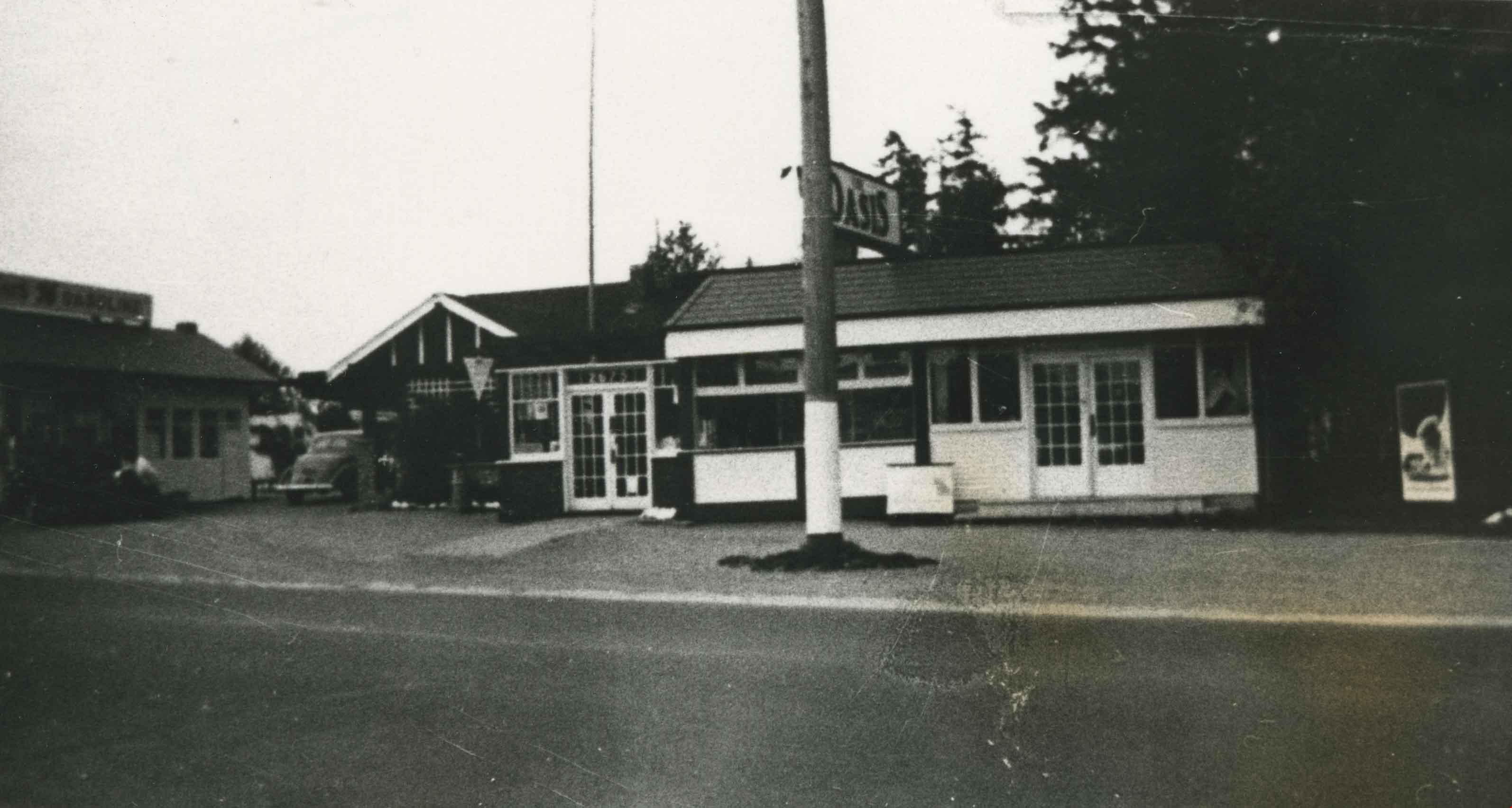
Oasis Restaurant
https://search.heritageburnaby.ca/link/archivedescription35629
- Repository
- City of Burnaby Archives
- Date
- 1926 (date of original), copied 1986
- Collection/Fonds
- Burnaby Historical Society fonds
- Description Level
- Item
- Physical Description
- 1 photograph : b&w ; 12.7 x 17.8 cm print
- Scope and Content
- Photograph of The Oasis restaurant, store, and night club (with dance floor), formerly The Oasis tea room. The Oasis was located at 2675 Kingsway (Pacific Highway). It was later renumbered 6105 Kingsway.
- Repository
- City of Burnaby Archives
- Date
- 1926 (date of original), copied 1986
- Collection/Fonds
- Burnaby Historical Society fonds
- Subseries
- Pioneer Tales subseries
- Physical Description
- 1 photograph : b&w ; 12.7 x 17.8 cm print
- Description Level
- Item
- Record No.
- 204-487
- Access Restriction
- No restrictions
- Reproduction Restriction
- No known restrictions
- Accession Number
- BHS1988-03
- Scope and Content
- Photograph of The Oasis restaurant, store, and night club (with dance floor), formerly The Oasis tea room. The Oasis was located at 2675 Kingsway (Pacific Highway). It was later renumbered 6105 Kingsway.
- Subjects
- Buildings - Commercial - Restaurants
- Names
- Oasis
- Media Type
- Photograph
- Notes
- Title based on contents of photograph
- Geographic Access
- Kingsway
- Street Address
- 6105 Kingsway
- Planning Study Area
- Windsor Area
Images
![The Oasis Suburban Café, [192-] thumbnail](/media/hpo/_Data/_Archives_Images/_Unrestricted/316/326-001.jpg?width=280)
The Oasis Suburban Café
https://search.heritageburnaby.ca/link/archivedescription37171
- Repository
- City of Burnaby Archives
- Date
- [192-]
- Collection/Fonds
- Burnaby Historical Society fonds
- Description Level
- Item
- Physical Description
- 1 photograph : sepia postcard ; 9.5 x 14 cm
- Scope and Content
- Photographic postcard of "'THE OASIS,' SUBURBAN CAFE" on Kingsway.
- Repository
- City of Burnaby Archives
- Date
- [192-]
- Collection/Fonds
- Burnaby Historical Society fonds
- Subseries
- Patterson family subseries
- Physical Description
- 1 photograph : sepia postcard ; 9.5 x 14 cm
- Description Level
- Item
- Record No.
- 326-001
- Access Restriction
- No restrictions
- Reproduction Restriction
- No known restrictions
- Accession Number
- BHS1996-11
- Scope and Content
- Photographic postcard of "'THE OASIS,' SUBURBAN CAFE" on Kingsway.
- Names
- Oasis
- Media Type
- Photograph
- Notes
- Annotation on recto of postcard reads: "'THE OASIS, SUBURBAN CAFE / A place of Refinement and Good Food. - On the Highway between New Westminster and Vancouver"
- Typed on verso of postcard reads: " Vancouver, B.C. / Dear ___________/ We just had Chicken Dinner at "The Oasis" Suburban Cafe, and I must say it was a real treat, everything was so tasty. If ever you motor up to Vancouver be sure and stop there. It is right on the Pacific Highway at 2675 Kingsway East, about three miles from New Westminster, and 20 minutes run from the Hotel Vancouver."
- Geographic Access
- Kingsway
- Street Address
- 6105 Kingsway
- Planning Study Area
- Windsor Area
Images
![The Oasis Suburban Café, [192-] thumbnail](/media/hpo/_Data/_Archives_Images/_Unrestricted/316/326-001.jpg)
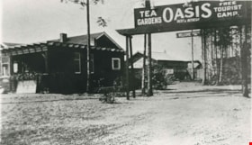
Oasis Tea Garden and Tourist Camp
https://search.heritageburnaby.ca/link/archivedescription35623
- Repository
- City of Burnaby Archives
- Date
- 1925 (date of original), copied 1986
- Collection/Fonds
- Burnaby Historical Society fonds
- Description Level
- Item
- Physical Description
- 1 photograph : b&w ; 12.7 x 17.8 cm print
- Scope and Content
- Photograph of the Oasis tea garden and tourist camp at 2675 Kingsway (Pacific Highway). It was later renumbered 6105 Kingsway. Guests could pitch tents for free at the campground and patronize the tea garden. The complex was operated by the Raymer family.
- Repository
- City of Burnaby Archives
- Date
- 1925 (date of original), copied 1986
- Collection/Fonds
- Burnaby Historical Society fonds
- Subseries
- Pioneer Tales subseries
- Physical Description
- 1 photograph : b&w ; 12.7 x 17.8 cm print
- Description Level
- Item
- Record No.
- 204-481
- Access Restriction
- No restrictions
- Reproduction Restriction
- No known restrictions
- Accession Number
- BHS1988-03
- Scope and Content
- Photograph of the Oasis tea garden and tourist camp at 2675 Kingsway (Pacific Highway). It was later renumbered 6105 Kingsway. Guests could pitch tents for free at the campground and patronize the tea garden. The complex was operated by the Raymer family.
- Names
- Oasis
- Media Type
- Photograph
- Notes
- Title based on contents of photograph
- Geographic Access
- Kingsway
- Street Address
- 6105 Kingsway
- Planning Study Area
- Windsor Area
Images

![Phillips-Hoyt Lumber Company, [1905] (date of original), copied 1992 thumbnail](/media/hpo/_Data/_Archives_Images/_Unrestricted/315/315-070.jpg?width=280)
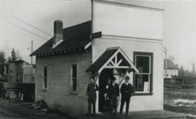
Phillips-Hoyt Lumber Company
https://search.heritageburnaby.ca/link/archivedescription36715
- Repository
- City of Burnaby Archives
- Date
- [1905] (date of original), copied 1992
- Collection/Fonds
- Burnaby Historical Society fonds
- Description Level
- Item
- Physical Description
- 1 photograph : b&w ; 8.3 x 12.0 cm print
- Scope and Content
- Photograph of the exterior of the building housing the Phillips, Hoyt Lumber Co. office with three men standing outside. The building was located at 2730 McKay Avenue (old street numbering system) and the site is now a part of the Burnaby Public Library site.
- Repository
- City of Burnaby Archives
- Date
- [1905] (date of original), copied 1992
- Collection/Fonds
- Burnaby Historical Society fonds
- Subseries
- Burnaby Centennial Anthology subseries
- Physical Description
- 1 photograph : b&w ; 8.3 x 12.0 cm print
- Description Level
- Item
- Record No.
- 315-070
- Access Restriction
- No restrictions
- Reproduction Restriction
- No known restrictions
- Accession Number
- BHS1994-04
- Scope and Content
- Photograph of the exterior of the building housing the Phillips, Hoyt Lumber Co. office with three men standing outside. The building was located at 2730 McKay Avenue (old street numbering system) and the site is now a part of the Burnaby Public Library site.
- Subjects
- Buildings - Commercial
- Media Type
- Photograph
- Notes
- Title based on contents of photograph
- Geographic Access
- Willingdon Avenue
- Street Address
- 6100 Willingdon Avenue
- Historic Neighbourhood
- Central Park (Historic Neighbourhood)
- Planning Study Area
- Maywood Area
Images
![Phillips-Hoyt Lumber Company, [1905] (date of original), copied 1992 thumbnail](/media/hpo/_Data/_Archives_Images/_Unrestricted/315/315-070.jpg)
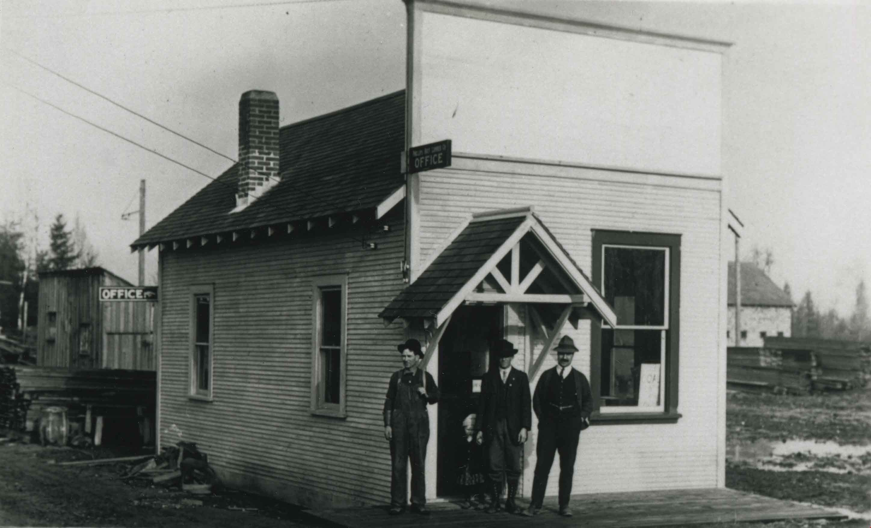
Phillips-Hoyt Lumber Company
https://search.heritageburnaby.ca/link/archivedescription36766
- Repository
- City of Burnaby Archives
- Date
- 1905 (date of original), copied 1992
- Collection/Fonds
- Burnaby Historical Society fonds
- Description Level
- Item
- Physical Description
- 1 photograph : b&w ; 7.9 x 12.5 cm print
- Scope and Content
- Photograph of the exterior of the Phillips, Hoyt Lumber Co. on McKay Avenue with three men standing in front. This property is now part of the Burnaby Public Library site.
- Repository
- City of Burnaby Archives
- Date
- 1905 (date of original), copied 1992
- Collection/Fonds
- Burnaby Historical Society fonds
- Subseries
- Burnaby Centennial Anthology subseries
- Physical Description
- 1 photograph : b&w ; 7.9 x 12.5 cm print
- Description Level
- Item
- Record No.
- 315-121
- Access Restriction
- No restrictions
- Reproduction Restriction
- No known restrictions
- Accession Number
- BHS1994-04
- Scope and Content
- Photograph of the exterior of the Phillips, Hoyt Lumber Co. on McKay Avenue with three men standing in front. This property is now part of the Burnaby Public Library site.
- Subjects
- Buildings - Commercial
- Media Type
- Photograph
- Notes
- Title based on contents of photograph
- Geographic Access
- McKay Avenue
- Willingdon Avenue
- Street Address
- 6100 Willingdon Avenue
- Historic Neighbourhood
- Central Park (Historic Neighbourhood)
- Planning Study Area
- Maywood Area
Images
Phillips-Hoyt Lumber Company after snowfall
https://search.heritageburnaby.ca/link/archivedescription36769
- Repository
- City of Burnaby Archives
- Date
- 1905 (date of original), copied 1992
- Collection/Fonds
- Burnaby Historical Society fonds
- Description Level
- Item
- Physical Description
- 1 photograph : b&w ; 12.6 x 8.7 cm print
- Scope and Content
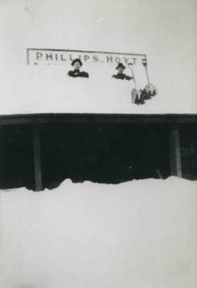
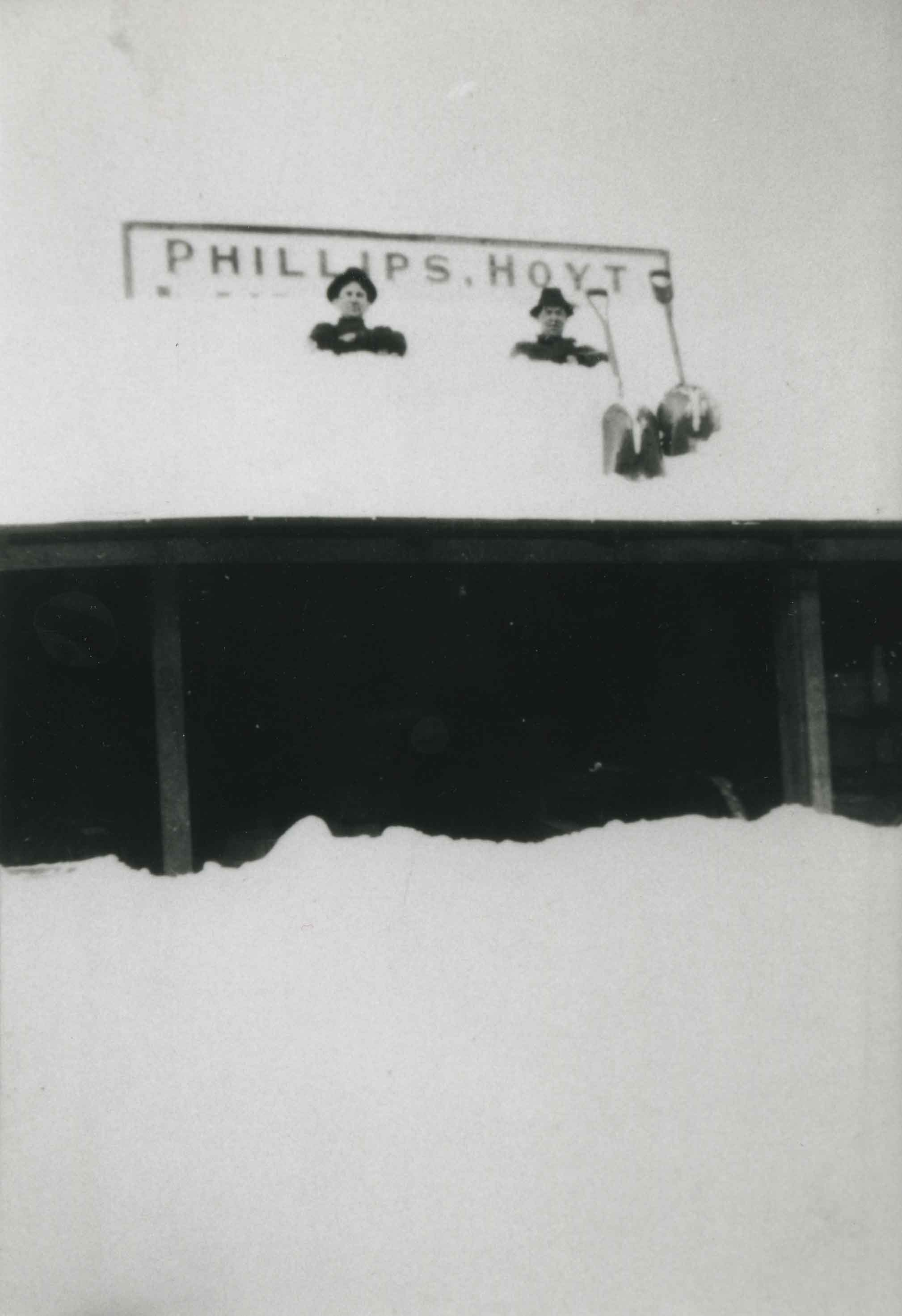
- Photograph of a building of the Phillips, Hoyt Lumber Co. after a snowfall. Two men are on the roof of the building with shovels.
- Repository
- City of Burnaby Archives
- Date
- 1905 (date of original), copied 1992
- Collection/Fonds
- Burnaby Historical Society fonds
- Subseries
- Burnaby Centennial Anthology subseries
- Physical Description
- 1 photograph : b&w ; 12.6 x 8.7 cm print
- Description Level
- Item
- Record No.
- 315-124
- Access Restriction
- No restrictions
- Reproduction Restriction
- No known restrictions
- Accession Number
- BHS1994-04
- Scope and Content
- Photograph of a building of the Phillips, Hoyt Lumber Co. after a snowfall. Two men are on the roof of the building with shovels.
- Subjects
- Buildings - Commercial
- Media Type
- Photograph
- Notes
- Title based on contents of photograph
- Geographic Access
- McKay Avenue
- Willingdon Avenue
- Street Address
- 6100 Willingdon Avenue
- Historic Neighbourhood
- Central Park (Historic Neighbourhood)
- Planning Study Area
- Maywood Area
Images
![Post Office and CPR Depot, [between 1908 and 1911] thumbnail](/media/hpo/_Data/_BVM_Images/1972/1972_0050_0001_002.jpg?width=280)
Post Office and CPR Depot
https://search.heritageburnaby.ca/link/museumdescription1062
- Repository
- Burnaby Village Museum
- Date
- [between 1908 and 1911]
- Collection/Fonds
- Burnaby Village Museum Photograph collection
- Description Level
- Item
- Physical Description
- 1 photograph : sepia ; 6.1 x 10.7 cm, mounted on album page 13.5 x 18.3 cm
- Scope and Content
- Photograph of a waterfront area in downtown Vancouver; the post office is visible to the left and the CPR depot to the right. The north shore can be seen faintly across Burrard Inlet in the background. A caption written on the album page in white ink reads, "Post Office and C.P.R. Depot / From Roo…
- Repository
- Burnaby Village Museum
- Collection/Fonds
- Burnaby Village Museum Photograph collection
- Description Level
- Item
- Physical Description
- 1 photograph : sepia ; 6.1 x 10.7 cm, mounted on album page 13.5 x 18.3 cm
- Scope and Content
- Photograph of a waterfront area in downtown Vancouver; the post office is visible to the left and the CPR depot to the right. The north shore can be seen faintly across Burrard Inlet in the background. A caption written on the album page in white ink reads, "Post Office and C.P.R. Depot / From Roof of Rogers Bldg / Vancouver B.C."
- Geographic Access
- Vancouver
- Accession Code
- HV972.50.1
- Access Restriction
- No restrictions
- Reproduction Restriction
- No known restrictions
- Date
- [between 1908 and 1911]
- Media Type
- Photograph
- Scan Resolution
- 600
- Scan Date
- 2023-03-28
- Photographer
- Dean, H.M.
- Notes
- Title based on caption of photograph
Images
![Post Office and CPR Depot, [between 1908 and 1911] thumbnail](/media/hpo/_Data/_BVM_Images/1972/1972_0050_0001_002.jpg)
![Rose Meat Market on Kingsway, [192-] (date of original), copied 1992 thumbnail](/media/hpo/_Data/_Archives_Images/_Unrestricted/315/315-052.jpg?width=280)
Rose Meat Market on Kingsway
https://search.heritageburnaby.ca/link/archivedescription36697
- Repository
- City of Burnaby Archives
- Date
- [192-] (date of original), copied 1992
- Collection/Fonds
- Burnaby Historical Society fonds
- Description Level
- Item
- Physical Description
- 1 photograph : b&w ; 12.5 x 8.5 cm print
- Scope and Content
- Photograph of the exterior of Rose Meat Market on Kingsway, an addition to Allen Sharpe's sign shop and store. Mr. Sharpe is on the right and Gwynne Everett Morris is on the left. Allen and Rose Sharpe had bought the property in 1919.
- Repository
- City of Burnaby Archives
- Date
- [192-] (date of original), copied 1992
- Collection/Fonds
- Burnaby Historical Society fonds
- Subseries
- Burnaby Centennial Anthology subseries
- Physical Description
- 1 photograph : b&w ; 12.5 x 8.5 cm print
- Description Level
- Item
- Record No.
- 315-052
- Access Restriction
- No restrictions
- Reproduction Restriction
- No known restrictions
- Accession Number
- BHS1994-04
- Scope and Content
- Photograph of the exterior of Rose Meat Market on Kingsway, an addition to Allen Sharpe's sign shop and store. Mr. Sharpe is on the right and Gwynne Everett Morris is on the left. Allen and Rose Sharpe had bought the property in 1919.
- Media Type
- Photograph
- Notes
- Title based on contents of photograph
- Geographic Access
- Kingsway
- Kathleen Avenue
- Street Address
- 4360 Kingsway
- Historic Neighbourhood
- Central Park (Historic Neighbourhood)
- Planning Study Area
- Maywood Area
Images
![Rose Meat Market on Kingsway, [192-] (date of original), copied 1992 thumbnail](/media/hpo/_Data/_Archives_Images/_Unrestricted/315/315-052.jpg)
![Ross Service Station, Douglas Road and Grandview Highway, 1922 (date of original), copied [1998] thumbnail](/media/hpo/_Data/_Archives_Images/_Unrestricted/316/358-001.jpg?width=280)
Ross Service Station, Douglas Road and Grandview Highway
https://search.heritageburnaby.ca/link/archivedescription37353
- Repository
- City of Burnaby Archives
- Date
- 1922 (date of original), copied [1998]
- Collection/Fonds
- Burnaby Historical Society fonds
- Description Level
- Item
- Physical Description
- 1 photograph : b&w ; 10 x 15 cm print
- Scope and Content
- Photograph of the Ross Service Station, located at Douglas road and Grandview Highway (now Canada Way). This station was built, owned and operated by Fred Ross.
- Repository
- City of Burnaby Archives
- Date
- 1922 (date of original), copied [1998]
- Collection/Fonds
- Burnaby Historical Society fonds
- Subseries
- Ross family subseries
- Physical Description
- 1 photograph : b&w ; 10 x 15 cm print
- Description Level
- Item
- Record No.
- 358-001
- Access Restriction
- No restrictions
- Reproduction Restriction
- No known restrictions
- Accession Number
- BHS1998-05
- Scope and Content
- Photograph of the Ross Service Station, located at Douglas road and Grandview Highway (now Canada Way). This station was built, owned and operated by Fred Ross.
- Names
- Ross Service Station
- Media Type
- Photograph
- Notes
- Title based on contents of photograph.
- The 1925 Burnaby Business Guide provides the address for this building as Douglas Road and Sprott Street.
- Geographic Access
- Douglas Road
- Sprott Street
- Canada Way
- Street Address
- 3355 Douglas Road
- Planning Study Area
- Douglas-Gilpin Area
Images
![Ross Service Station, Douglas Road and Grandview Highway, 1922 (date of original), copied [1998] thumbnail](/media/hpo/_Data/_Archives_Images/_Unrestricted/316/358-001.jpg)
![Royal Oak Garage, [1925] thumbnail](/media/hpo/_Data/_BVM_Images/1993/1993_0028_0036_001.jpg?width=280)
Royal Oak Garage
https://search.heritageburnaby.ca/link/museumdescription1253
- Repository
- Burnaby Village Museum
- Date
- [1925]
- Collection/Fonds
- Burnaby Village Museum Photograph collection
- Description Level
- Item
- Physical Description
- 1 photograph : b&w ; 19.5 x 24.5 cm
- Scope and Content
- Photograph of the Royal Oak Garage taken from a distance. A man is sitting in a tow truck in front of the garage, facing the camera. Three other cars are on site, including one which looks to be a 1925 Ford Runabout. Advertisements for "IMPERIAL PREMIER GASOLINE" and "SHELL GASOLINE" are visible. T…
- Repository
- Burnaby Village Museum
- Collection/Fonds
- Burnaby Village Museum Photograph collection
- Description Level
- Item
- Physical Description
- 1 photograph : b&w ; 19.5 x 24.5 cm
- Scope and Content
- Photograph of the Royal Oak Garage taken from a distance. A man is sitting in a tow truck in front of the garage, facing the camera. Three other cars are on site, including one which looks to be a 1925 Ford Runabout. Advertisements for "IMPERIAL PREMIER GASOLINE" and "SHELL GASOLINE" are visible. The Royal Oak Garage was located at 3439 Kingsway (later renumbered 5103 Kingsway).
- Subjects
- Buildings - Commercial - Service Stations
- Transportation - Automobiles
- Transportation - Trucks
- Names
- Royal Oak Garage
- Geographic Access
- Kingsway
- Street Address
- 5103 Kingsway
- Accession Code
- BV993.28.36
- Access Restriction
- No restrictions
- Reproduction Restriction
- No known restrictions
- Date
- [1925]
- Media Type
- Photograph
- Historic Neighbourhood
- Central Park (Historic Neighbourhood)
- Planning Study Area
- Marlborough Area
- Related Material
- For a copy print of this photograph, see BV993.28.33
- Scan Resolution
- 600
- Scan Date
- 2024-04-23
- Notes
- Title based on contents of photograph
- Note on verso of photograph reads: "JENNIFER CULLEN/ DIV 8/ THIS SHOP WAS OWNED BY JENNIFER'S/ GREAT GRANDFATHER CULLEN/ 5000 BLOCK KINGSWAY BURNABY"
Images
![Royal Oak Garage, [1925] thumbnail](/media/hpo/_Data/_BVM_Images/1993/1993_0028_0036_001.jpg)