More like 'Interview with Elsie Ansdell by Eric Damer September 18, 2012 - Track 1'
Narrow Results By
Subject
- Animals - Cats 1
- Buildings - Residential - Houses 1
- Construction Tools and Equipment 1
- Energy Production Tools and Equipment 1
- Geographic Features - Creeks 1
- Geographic Features - Lakes and Ponds 2
- Geographic Features - Roads 5
- Industries - Forestry 1
- Industries - Logging/lumber 1
- Land Clearing 32
- Natural Phenomena - Snow 1
- Occupations - Labourers 3

Allanson family clearing land
https://search.heritageburnaby.ca/link/archivedescription35793
- Repository
- City of Burnaby Archives
- Date
- 1923 (date of original), copied 1986
- Collection/Fonds
- Burnaby Historical Society fonds
- Description Level
- Item
- Physical Description
- 1 photograph : b&w ; 12.7 x 17.8 cm print
- Scope and Content
- Photograph of the Allanson family clearing the land at 12 Warwick Avenue bought by Malcolm and Mabel Allanson. Left to right: William Allanson, Mabel Allanson, Malcolm Allanson, and Jessie Allanson. William and Jessie Allanson are the parents of Malcolm. Mabel and Malcolm Allanson are married.
- Repository
- City of Burnaby Archives
- Date
- 1923 (date of original), copied 1986
- Collection/Fonds
- Burnaby Historical Society fonds
- Subseries
- Pioneer Tales subseries
- Physical Description
- 1 photograph : b&w ; 12.7 x 17.8 cm print
- Description Level
- Item
- Record No.
- 204-651
- Access Restriction
- No restrictions
- Reproduction Restriction
- No known restrictions
- Accession Number
- BHS1988-03
- Scope and Content
- Photograph of the Allanson family clearing the land at 12 Warwick Avenue bought by Malcolm and Mabel Allanson. Left to right: William Allanson, Mabel Allanson, Malcolm Allanson, and Jessie Allanson. William and Jessie Allanson are the parents of Malcolm. Mabel and Malcolm Allanson are married.
- Subjects
- Land Clearing
- Plants - Trees
- Media Type
- Photograph
- Notes
- Title based on contents of photograph
- Geographic Access
- Warwick Avenue
- Street Address
- 12 Warwick Avenue
- Historic Neighbourhood
- Capitol Hill (Historic Neighbourhood)
- Planning Study Area
- Capitol Hill Area
Images


Annie Eshelby in front of a felled tree
https://search.heritageburnaby.ca/link/archivedescription35363
- Repository
- City of Burnaby Archives
- Date
- 1924
- Collection/Fonds
- Burnaby Historical Society fonds
- Description Level
- Item
- Physical Description
- 1 photograph : b&w ; 12.7 x 17.8 cm print
- Scope and Content
- Photograph of Mrs. Annie Eshelby in front of a felled tree measuring six feet in diameter. She is sitting on a chair with a black and white cat lying across her lap. This photograph was taken at the lot on Fell Avenue and Dundas Street, North Burnaby, which was cleared for the Eshelby family home. …
- Repository
- City of Burnaby Archives
- Date
- 1924
- Collection/Fonds
- Burnaby Historical Society fonds
- Subseries
- Pioneer Tales subseries
- Physical Description
- 1 photograph : b&w ; 12.7 x 17.8 cm print
- Description Level
- Item
- Record No.
- 204-220
- Access Restriction
- No restrictions
- Reproduction Restriction
- No known restrictions
- Accession Number
- BHS1988-03
- Scope and Content
- Photograph of Mrs. Annie Eshelby in front of a felled tree measuring six feet in diameter. She is sitting on a chair with a black and white cat lying across her lap. This photograph was taken at the lot on Fell Avenue and Dundas Street, North Burnaby, which was cleared for the Eshelby family home. Annie Eshelby (nee Perrey) was married to Frank Eshelby. They settled in Burnaby after moving from England in 1922.
- Subjects
- Animals - Cats
- Land Clearing
- Plants - Trees
- Names
- Eshelby, Annie Perrey
- Media Type
- Photograph
- Notes
- Title based on contents of photograph
- Geographic Access
- Fell Avenue
- Dundas Street
- Historic Neighbourhood
- Capitol Hill (Historic Neighbourhood)
- Planning Study Area
- Capitol Hill Area
Images


Barnet Wagon Road
https://search.heritageburnaby.ca/link/archivedescription38306
- Repository
- City of Burnaby Archives
- Date
- June 1903 (date of original), copied ca. 1990
- Collection/Fonds
- Burnaby Historical Society fonds
- Description Level
- Item
- Physical Description
- 1 photograph : b&w ; 10 x 15 cm print
- Scope and Content
- Photograph of the Barnet Wagon Road looking west from Sperling Avenue.
- Repository
- City of Burnaby Archives
- Date
- June 1903 (date of original), copied ca. 1990
- Collection/Fonds
- Burnaby Historical Society fonds
- Subseries
- Photographs subseries
- Physical Description
- 1 photograph : b&w ; 10 x 15 cm print
- Description Level
- Item
- Record No.
- 403-001
- Access Restriction
- No restrictions
- Reproduction Restriction
- No known restrictions
- Accession Number
- BHS2007-04
- Scope and Content
- Photograph of the Barnet Wagon Road looking west from Sperling Avenue.
- Subjects
- Land Clearing
- Geographic Features - Roads
- Media Type
- Photograph
- Notes
- Title based on contents of photograph
- Geographic Access
- Barnet Road
- Sperling Avenue
- Historic Neighbourhood
- Lochdale (Historic Neighbourhood)
- Planning Study Area
- Westridge Area
Images


Barnet Wagon Road
https://search.heritageburnaby.ca/link/archivedescription38307
- Repository
- City of Burnaby Archives
- Date
- June 1903 (date of original), copied ca. 1990
- Collection/Fonds
- Burnaby Historical Society fonds
- Description Level
- Item
- Physical Description
- 1 photograph : b&w ; 10 x 15 cm print
- Scope and Content
- Photograph of the Barnet Wagon Road looking east, near Barnet and Hastings.
- Repository
- City of Burnaby Archives
- Date
- June 1903 (date of original), copied ca. 1990
- Collection/Fonds
- Burnaby Historical Society fonds
- Subseries
- Photographs subseries
- Physical Description
- 1 photograph : b&w ; 10 x 15 cm print
- Description Level
- Item
- Record No.
- 403-002
- Access Restriction
- No restrictions
- Reproduction Restriction
- No known restrictions
- Accession Number
- BHS2007-04
- Scope and Content
- Photograph of the Barnet Wagon Road looking east, near Barnet and Hastings.
- Subjects
- Land Clearing
- Geographic Features - Roads
- Media Type
- Photograph
- Notes
- Title based on contents of photograph
- Geographic Access
- Barnet Road
- Hastings Street
- Historic Neighbourhood
- Lochdale (Historic Neighbourhood)
- Planning Study Area
- Westridge Area
Images


Claude Hill beside a large felled tree
https://search.heritageburnaby.ca/link/archivedescription39517
- Repository
- City of Burnaby Archives
- Date
- 1900
- Collection/Fonds
- Peers Family and Hill Family fonds
- Description Level
- Item
- Physical Description
- 1 photograph : b&w ; 10.5 x 15 cm on page 21.5 x 28 cm (pasted in album)
- Scope and Content
- Photograph of Louis Claude Hill standing by a ladder placed in a ditch. The ladder is leaning against a giant tree upturned by the roots. The ditch appears to be created from uprooting the tree. There is a pile of firewood visible to the right, and a barn to the left in the distance.
- Repository
- City of Burnaby Archives
- Date
- 1900
- Collection/Fonds
- Peers Family and Hill Family fonds
- Physical Description
- 1 photograph : b&w ; 10.5 x 15 cm on page 21.5 x 28 cm (pasted in album)
- Description Level
- Item
- Record No.
- 477-836
- Access Restriction
- No restrictions
- Reproduction Restriction
- No known restrictions
- Accession Number
- 2007-12
- Scope and Content
- Photograph of Louis Claude Hill standing by a ladder placed in a ditch. The ladder is leaning against a giant tree upturned by the roots. The ditch appears to be created from uprooting the tree. There is a pile of firewood visible to the right, and a barn to the left in the distance.
- Subjects
- Land Clearing
- Plants - Trees
- Media Type
- Photograph
- Notes
- Title based on contents of photograph
- Geographic Access
- Deer Lake Avenue
- Historic Neighbourhood
- Burnaby Lake (Historic Neighbourhood)
Images

, copied 1978 thumbnail](/media/hpo/_Data/_BVM_Images/1977/197800010016.jpg?width=280)
Cleared land
https://search.heritageburnaby.ca/link/museumdescription462
- Repository
- Burnaby Village Museum
- Date
- [190-](date of original), copied 1978
- Collection/Fonds
- Burnaby Village Museum Photograph collection
- Description Level
- Item
- Physical Description
- 1 photograph : b&w ; 20.2 x 25.2 cm print
- Scope and Content
- Photograph of the cleared land which appears to be the Sprott family property. There are stumps and felled trees on the lot. Across a small dirt road and behind a wooden fence, the Haszard house is visible to the extreme right of the photograph.
- Repository
- Burnaby Village Museum
- Collection/Fonds
- Burnaby Village Museum Photograph collection
- Description Level
- Item
- Physical Description
- 1 photograph : b&w ; 20.2 x 25.2 cm print
- Scope and Content
- Photograph of the cleared land which appears to be the Sprott family property. There are stumps and felled trees on the lot. Across a small dirt road and behind a wooden fence, the Haszard house is visible to the extreme right of the photograph.
- Subjects
- Land Clearing
- Plants - Trees
- Geographic Access
- Canada Way
- Accession Code
- HV978.1.16
- Access Restriction
- No restrictions
- Reproduction Restriction
- No known restrictions
- Date
- [190-](date of original), copied 1978
- Media Type
- Photograph
- Historic Neighbourhood
- Burnaby Lake (Historic Neighbourhood)
- Scan Resolution
- 600
- Scan Date
- 2023-08-01
- Notes
- Title based on contents of photograph
Images
, copied 1978 thumbnail](/media/hpo/_Data/_BVM_Images/1977/197800010016.jpg)

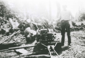
Digging In
https://search.heritageburnaby.ca/link/archivedescription34387
- Repository
- City of Burnaby Archives
- Date
- 1926
- Collection/Fonds
- Burnaby Historical Society fonds
- Description Level
- Item
- Physical Description
- 1 photograph : b&w ; 7.5 x 7 cm on page 17.5 x 26.5 cm
- Scope and Content
- Photograph of a steam shovel digging into a hill. A horse team pulling a dump wagon stand next to it. The location is unknown. This photograph appears to have been taken by Arthur Peers, who travelled through the Fraser River Valley and worked on the construction of the Trans-Provincial Highway dur…
- Repository
- City of Burnaby Archives
- Date
- 1926
- Collection/Fonds
- Burnaby Historical Society fonds
- Subseries
- Peers family subseries
- Physical Description
- 1 photograph : b&w ; 7.5 x 7 cm on page 17.5 x 26.5 cm
- Description Level
- Item
- Record No.
- 020-094
- Access Restriction
- No restrictions
- Reproduction Restriction
- No known restrictions
- Accession Number
- BHS2007-04
- Scope and Content
- Photograph of a steam shovel digging into a hill. A horse team pulling a dump wagon stand next to it. The location is unknown. This photograph appears to have been taken by Arthur Peers, who travelled through the Fraser River Valley and worked on the construction of the Trans-Provincial Highway during the later 1920s.
- Subjects
- Land Clearing
- Occupations - Labourers
- Transportation - Horses
- Transportation - Wagons
- Construction Tools and Equipment
- Media Type
- Photograph
- Photographer
- Peers, Arthur Francis "Mike"
- Notes
- Title based on caption accompanying photograph
Images

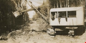
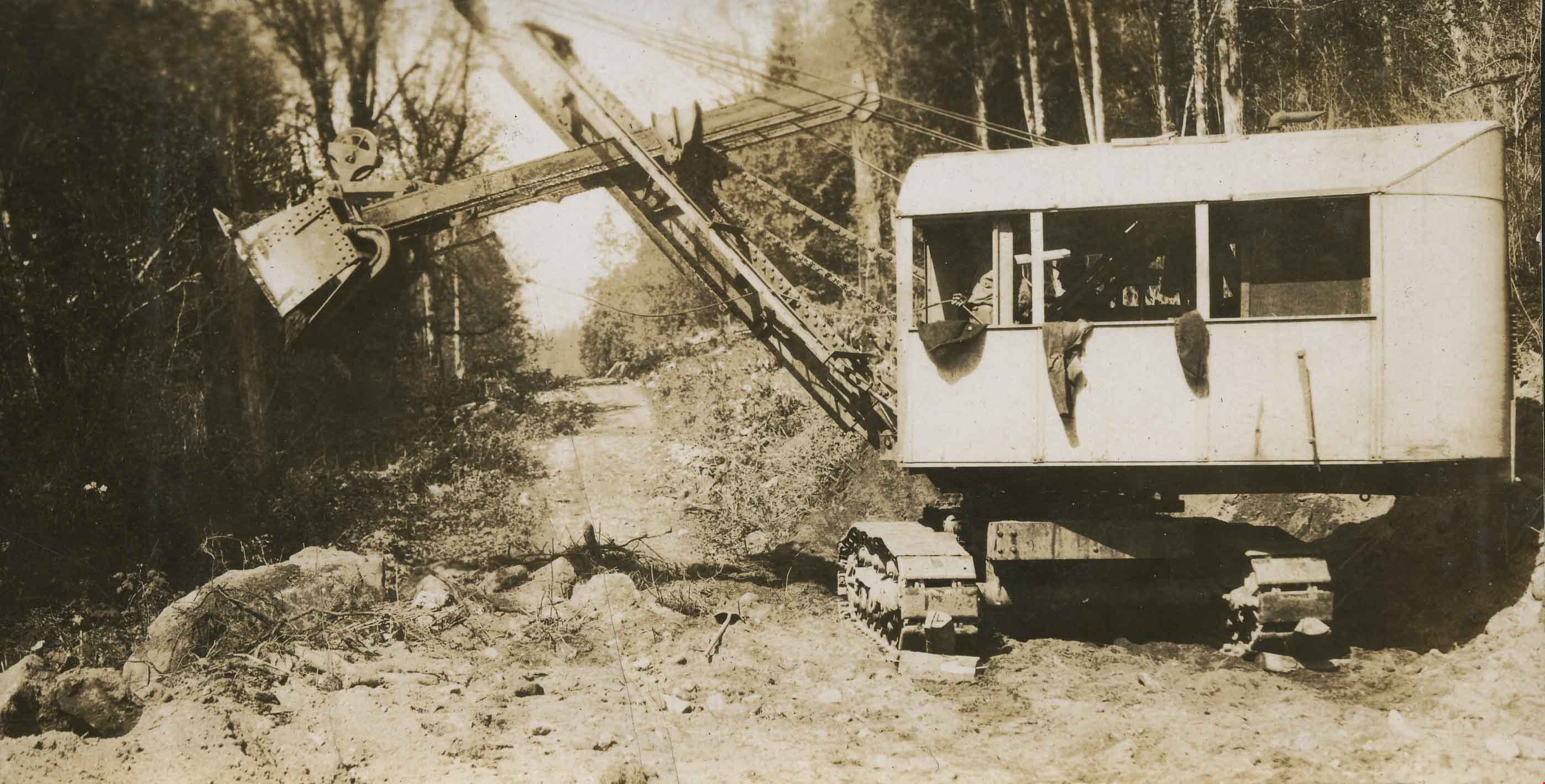
Dropping the load
https://search.heritageburnaby.ca/link/archivedescription34388
- Repository
- City of Burnaby Archives
- Date
- 1926
- Collection/Fonds
- Burnaby Historical Society fonds
- Description Level
- Item
- Physical Description
- 1 photograph : 6.3 x 11.8 cm on page 17.5 x 26.5 cm
- Scope and Content
- Photograph of a steam shovel working in a cleared path through the woods. The location is unknown. This photograph appears to have been taken by Arthur Peers, who travelled through the Fraser River Valley and worked on the construction of the Trans-Provincial Highway during the later 1920s.
- Repository
- City of Burnaby Archives
- Date
- 1926
- Collection/Fonds
- Burnaby Historical Society fonds
- Subseries
- Peers family subseries
- Physical Description
- 1 photograph : 6.3 x 11.8 cm on page 17.5 x 26.5 cm
- Description Level
- Item
- Record No.
- 020-095
- Access Restriction
- No restrictions
- Reproduction Restriction
- No known restrictions
- Accession Number
- BHS2007-04
- Scope and Content
- Photograph of a steam shovel working in a cleared path through the woods. The location is unknown. This photograph appears to have been taken by Arthur Peers, who travelled through the Fraser River Valley and worked on the construction of the Trans-Provincial Highway during the later 1920s.
- Subjects
- Land Clearing
- Media Type
- Photograph
- Photographer
- Peers, Arthur Francis "Mike"
- Notes
- Title based on caption accompanying photograph
Images
Easthope Gasoline Stump Puller
https://search.heritageburnaby.ca/link/archivedescription37049
- Repository
- City of Burnaby Archives
- Date
- 1927 (date of original), copied 1992
- Collection/Fonds
- Burnaby Historical Society fonds
- Description Level
- Item
- Physical Description
- 1 photograph : b&w ; 8.7 x 12.7 cm print
- Scope and Content
- Photograph of a man standing beside an Easthope Gasoline Stump Puller used for clearing land.
- Repository
- City of Burnaby Archives
- Date
- 1927 (date of original), copied 1992
- Collection/Fonds
- Burnaby Historical Society fonds
- Subseries
- Burnaby Centennial Anthology subseries
- Physical Description
- 1 photograph : b&w ; 8.7 x 12.7 cm print
- Description Level
- Item
- Record No.
- 315-512
- Access Restriction
- No restrictions
- Reproduction Restriction
- No known restrictions
- Accession Number
- BHS1994-04
- Scope and Content
- Photograph of a man standing beside an Easthope Gasoline Stump Puller used for clearing land.
- Subjects
- Land Clearing
- Occupations - Labourers
- Media Type
- Photograph
- Notes
- Title based on contents of photograph
Images

![Easthope Gasoline Stump Puller, [192-?] (date of original), copied 1992 thumbnail](/media/hpo/_Data/_Archives_Images/_Unrestricted/315/315-513.jpg?width=280)
Easthope Gasoline Stump Puller
https://search.heritageburnaby.ca/link/archivedescription37050
- Repository
- City of Burnaby Archives
- Date
- [192-?] (date of original), copied 1992
- Collection/Fonds
- Burnaby Historical Society fonds
- Description Level
- Item
- Physical Description
- 1 photograph : b&w ; 8.7 x 12.7 cm print
- Scope and Content
- Photograph of a man standing beside an Easthope Gasoline Stump Puller used for clearing land. In the background another man is standing beside a pile of stumps.
- Repository
- City of Burnaby Archives
- Date
- [192-?] (date of original), copied 1992
- Collection/Fonds
- Burnaby Historical Society fonds
- Subseries
- Burnaby Centennial Anthology subseries
- Physical Description
- 1 photograph : b&w ; 8.7 x 12.7 cm print
- Description Level
- Item
- Record No.
- 315-513
- Access Restriction
- No restrictions
- Reproduction Restriction
- No known restrictions
- Accession Number
- BHS1994-04
- Scope and Content
- Photograph of a man standing beside an Easthope Gasoline Stump Puller used for clearing land. In the background another man is standing beside a pile of stumps.
- Subjects
- Land Clearing
- Occupations - Labourers
- Media Type
- Photograph
- Notes
- Title based on contents of photograph
Images
![Easthope Gasoline Stump Puller, [192-?] (date of original), copied 1992 thumbnail](/media/hpo/_Data/_Archives_Images/_Unrestricted/315/315-513.jpg)

Ernie Carpenter clearing land
https://search.heritageburnaby.ca/link/archivedescription35789
- Repository
- City of Burnaby Archives
- Date
- 1923 (date of original), copied 1986
- Collection/Fonds
- Burnaby Historical Society fonds
- Description Level
- Item
- Physical Description
- 1 photograph : b&w ; 12.7 x 17.8 cm print
- Scope and Content
- Photograph of Ernie Carpenter clearing a lot at 3336 Beresford Street (later renumbered 5268 Beresford Street) near Royal Oak Avenue. Mr. Carpenter built a house here, and then cultivated an English garden and prize-winning onions and flowers.
- Repository
- City of Burnaby Archives
- Date
- 1923 (date of original), copied 1986
- Collection/Fonds
- Burnaby Historical Society fonds
- Subseries
- Pioneer Tales subseries
- Physical Description
- 1 photograph : b&w ; 12.7 x 17.8 cm print
- Description Level
- Item
- Record No.
- 204-647
- Access Restriction
- No restrictions
- Reproduction Restriction
- No known restrictions
- Accession Number
- BHS1988-03
- Scope and Content
- Photograph of Ernie Carpenter clearing a lot at 3336 Beresford Street (later renumbered 5268 Beresford Street) near Royal Oak Avenue. Mr. Carpenter built a house here, and then cultivated an English garden and prize-winning onions and flowers.
- Subjects
- Land Clearing
- Plants - Trees
- Names
- Carpenter, Ernie
- Media Type
- Photograph
- Notes
- Title based on contents of photograph
- Geographic Access
- Beresford Street
- Street Address
- 5268 Beresford Street
- Historic Neighbourhood
- Central Park (Historic Neighbourhood)
- Planning Study Area
- Windsor Area
Images

![Gus Rintanen, [192-] (date of original), digitally copied 2012 thumbnail](/media/hpo/_Data/_Archives_Images/_Unrestricted/540/549-076.jpg?width=280)
Gus Rintanen
https://search.heritageburnaby.ca/link/archivedescription76945
- Repository
- City of Burnaby Archives
- Date
- [192-] (date of original), digitally copied 2012
- Collection/Fonds
- Community Heritage Commission Special Projects fonds
- Description Level
- Item
- Physical Description
- 1 photograph (jpeg) : col. ; 300ppi
- Scope and Content
- Photograph of Gus Rintanen clearing land with an unidentified man in either Oregon or Washington.
- Repository
- City of Burnaby Archives
- Date
- [192-] (date of original), digitally copied 2012
- Collection/Fonds
- Community Heritage Commission Special Projects fonds
- Physical Description
- 1 photograph (jpeg) : col. ; 300ppi
- Description Level
- Item
- Record No.
- 549-076
- Access Restriction
- No restrictions
- Reproduction Restriction
- No known restrictions
- Accession Number
- 2012-30
- Scope and Content
- Photograph of Gus Rintanen clearing land with an unidentified man in either Oregon or Washington.
- Subjects
- Land Clearing
- Names
- Rintanen, Gus
- Media Type
- Photograph
- Notes
- Title based on contents of photograph
Images
![Gus Rintanen, [192-] (date of original), digitally copied 2012 thumbnail](/media/hpo/_Data/_Archives_Images/_Unrestricted/540/549-076.jpg)
, copied 1978 thumbnail](/media/hpo/_Data/_BVM_Images/1978/1978_0001_0003_001.jpg?width=280)
Haszard house
https://search.heritageburnaby.ca/link/museumdescription449
- Repository
- Burnaby Village Museum
- Date
- [190-](date of original), copied 1978
- Collection/Fonds
- Burnaby Village Museum Photograph collection
- Description Level
- Item
- Physical Description
- 1 photograph : b&w ; 20.2 x 25.2 cm print
- Scope and Content
- Photograph of a house in a clearing just on the outskirts of densely wooded area. There is a wooden fence around the property, and in front of the house is a dirt road. There are small piles of logs along the road side. An earlier catalogue record identifies this house as the Haszard house that was…
- Repository
- Burnaby Village Museum
- Collection/Fonds
- Burnaby Village Museum Photograph collection
- Description Level
- Item
- Physical Description
- 1 photograph : b&w ; 20.2 x 25.2 cm print
- Scope and Content
- Photograph of a house in a clearing just on the outskirts of densely wooded area. There is a wooden fence around the property, and in front of the house is a dirt road. There are small piles of logs along the road side. An earlier catalogue record identifies this house as the Haszard house that was located across the street from the property of the Sprott Farm. The photograph was taken from Douglas Road (later renamed in part Canada Way). It is also noted that the Sprott family lived in the Haszard house while their home, named "Dovecote" was being completed.
- Geographic Access
- Douglas Road
- Canada Way
- Accession Code
- HV978.1.3
- Access Restriction
- No restrictions
- Reproduction Restriction
- No known restrictions
- Date
- [190-](date of original), copied 1978
- Media Type
- Photograph
- Historic Neighbourhood
- Burnaby Lake (Historic Neighbourhood)
- Scan Resolution
- 600
- Scan Date
- 2023-07-25
- Notes
- Title based on contents of photograph
Images
, copied 1978 thumbnail](/media/hpo/_Data/_BVM_Images/1978/1978_0001_0003_001.jpg)

Kask Camp
https://search.heritageburnaby.ca/link/archivedescription37413
- Repository
- City of Burnaby Archives
- Date
- May 14, 1924 (date of original), copied 1991
- Collection/Fonds
- Burnaby Historical Society fonds
- Description Level
- Item
- Physical Description
- 1 photograph : b&w ; 3.4 x 5.6 cm print on contact sheet 20.2 x 25.4 cm
- Scope and Content
- Photograph of the plot for the first house built at Kask Camp. The electricity lines shown are from Buntzen Power Plant. Barnet Road is seen on the right.
- Repository
- City of Burnaby Archives
- Date
- May 14, 1924 (date of original), copied 1991
- Collection/Fonds
- Burnaby Historical Society fonds
- Subseries
- Burnaby Image Bank subseries
- Physical Description
- 1 photograph : b&w ; 3.4 x 5.6 cm print on contact sheet 20.2 x 25.4 cm
- Description Level
- Item
- Record No.
- 370-001
- Access Restriction
- No restrictions
- Reproduction Restriction
- No known restrictions
- Accession Number
- BHS1999-03
- Scope and Content
- Photograph of the plot for the first house built at Kask Camp. The electricity lines shown are from Buntzen Power Plant. Barnet Road is seen on the right.
- Names
- Kask Camp
- Media Type
- Photograph
- Photographer
- Kask, William Sr.
- Notes
- Title based on contents of photograph
- 1 b&w copy negative accompanying
- Geographic Access
- Barnet Road
- Street Address
- 7501 Barnet Road
- Historic Neighbourhood
- Barnet (Historic Neighbourhood)
- Planning Study Area
- Burnaby Mountain Area
Images


Kinnunen's Creek
https://search.heritageburnaby.ca/link/archivedescription34381
- Repository
- City of Burnaby Archives
- Date
- 1926
- Collection/Fonds
- Burnaby Historical Society fonds
- Description Level
- Item
- Physical Description
- 1 photograph : b&w ; 6 x 12.4 cm on page 17.5 x 26.5 cm
- Scope and Content
- Photograph taken looking down Kinnunen's Creek with fallen trees and branches along the banks. This photograph appears to have been taken by Arthur Peers, who travelled through the Fraser River Valley and worked on the construction of the Trans-Provincial Highway during the later 1920s.
- Repository
- City of Burnaby Archives
- Date
- 1926
- Collection/Fonds
- Burnaby Historical Society fonds
- Subseries
- Peers family subseries
- Physical Description
- 1 photograph : b&w ; 6 x 12.4 cm on page 17.5 x 26.5 cm
- Description Level
- Item
- Record No.
- 020-088
- Access Restriction
- No restrictions
- Reproduction Restriction
- No known restrictions
- Accession Number
- BHS2007-04
- Scope and Content
- Photograph taken looking down Kinnunen's Creek with fallen trees and branches along the banks. This photograph appears to have been taken by Arthur Peers, who travelled through the Fraser River Valley and worked on the construction of the Trans-Provincial Highway during the later 1920s.
- Media Type
- Photograph
- Photographer
- Peers, Arthur Francis "Mike"
- Notes
- Title based on caption accompanying photograph
Images

![Lake, [1905] thumbnail](/media/hpo/_Data/_Archives_Images/_Unrestricted/477/477-135.jpg?width=280)
Lake
https://search.heritageburnaby.ca/link/archivedescription38816
- Repository
- City of Burnaby Archives
- Date
- [1905]
- Collection/Fonds
- Peers Family and Hill Family fonds
- Description Level
- Item
- Physical Description
- 1 photograph : b&w ; 5.5 x 5.5 cm on page 11.5 x 14 cm (pasted in album)
- Scope and Content
- Photograph of a lake (either Deer Lake or Burnaby Lake) with cleared land in the background.
- Repository
- City of Burnaby Archives
- Date
- [1905]
- Collection/Fonds
- Peers Family and Hill Family fonds
- Physical Description
- 1 photograph : b&w ; 5.5 x 5.5 cm on page 11.5 x 14 cm (pasted in album)
- Description Level
- Item
- Record No.
- 477-135
- Access Restriction
- No restrictions
- Reproduction Restriction
- No known restrictions
- Accession Number
- 2007-12
- Scope and Content
- Photograph of a lake (either Deer Lake or Burnaby Lake) with cleared land in the background.
- Media Type
- Photograph
- Notes
- Title based on contents of photograph
- Historic Neighbourhood
- Burnaby Lake (Historic Neighbourhood)
Images
![Lake, [1905] thumbnail](/media/hpo/_Data/_Archives_Images/_Unrestricted/477/477-135.jpg)

Land being cleared for Saint Theresa's Roman Catholic Church
https://search.heritageburnaby.ca/link/museumdescription902
- Repository
- Burnaby Village Museum
- Date
- 1929
- Collection/Fonds
- Burnaby Village Museum Photograph collection
- Description Level
- Item
- Physical Description
- 1 photograph : b&w ; 6.7 x 11.4 cm
- Scope and Content
- Photograph of three unidentified men standing on Douglas Road (later renamed in part Canada Way) with Laurel Street in the background on the left and the site of Saint Theresa's Roman Catholic Church as a lot with blackened stumps. The church was located at the southeast corner of Canada Way and L…
- Repository
- Burnaby Village Museum
- Collection/Fonds
- Burnaby Village Museum Photograph collection
- Description Level
- Item
- Physical Description
- 1 photograph : b&w ; 6.7 x 11.4 cm
- Scope and Content
- Photograph of three unidentified men standing on Douglas Road (later renamed in part Canada Way) with Laurel Street in the background on the left and the site of Saint Theresa's Roman Catholic Church as a lot with blackened stumps. The church was located at the southeast corner of Canada Way and Laurel Street. According to an accompanying note located with the photograph, the first church building burned to the ground the night before it was to be blessed. Insurance for the church had been arranged for by Colonel Dorrell only hours before it was burned and even though signatures had not been affixed to the policy, the insurance company honoured the claim. The second building was smaller and had no basement. Father Trainer was the first priest. This church was torn down in 1974 and a new church building was erected across the road on Canada Way.
- Subjects
- Land Clearing
- Geographic Access
- Douglas Road
- Canada Way
- Laurel Street
- Accession Code
- HV975.105.1
- Access Restriction
- No restrictions
- Reproduction Restriction
- No known restrictions
- Date
- 1929
- Media Type
- Photograph
- Historic Neighbourhood
- Burnaby Lake (Historic Neighbourhood)
- Planning Study Area
- Douglas-Gilpin Area
- Scan Resolution
- 600
- Scan Date
- 2023-06-06
- Notes
- Title based on contents of photograph
- Information on the scope and content of the photograph is taken from an acquisition record from the time of the accession
Images

![Land clearing, [190-] (date of original), copied 1978 thumbnail](/media/hpo/_Data/_BVM_Images/1977/197800010007.jpg?width=280)
Land clearing
https://search.heritageburnaby.ca/link/museumdescription453
- Repository
- Burnaby Village Museum
- Date
- [190-] (date of original), copied 1978
- Collection/Fonds
- Burnaby Village Museum Photograph collection
- Description Level
- Item
- Physical Description
- 1 photograph : b&w ; 20.2 x 25.2 cm print
- Scope and Content
- Photograph of a cleared property with a thick wooded area just behind it. There is a house in the back to the extreme left of the photograph that has been identified as the Haszard house where the Sprott family stayed while building their farmhouse known as "Dovecote." There are unidentified men i…
- Repository
- Burnaby Village Museum
- Collection/Fonds
- Burnaby Village Museum Photograph collection
- Description Level
- Item
- Physical Description
- 1 photograph : b&w ; 20.2 x 25.2 cm print
- Scope and Content
- Photograph of a cleared property with a thick wooded area just behind it. There is a house in the back to the extreme left of the photograph that has been identified as the Haszard house where the Sprott family stayed while building their farmhouse known as "Dovecote." There are unidentified men in the cleared field.
- Subjects
- Land Clearing
- Geographic Access
- Canada Way
- Accession Code
- HV978.1.7
- Access Restriction
- No restrictions
- Reproduction Restriction
- No known restrictions
- Date
- [190-] (date of original), copied 1978
- Media Type
- Photograph
- Historic Neighbourhood
- Burnaby Lake (Historic Neighbourhood)
- Scan Resolution
- 600
- Scan Date
- 2023-08-01
- Notes
- Title based on contents of photograph
Images
![Land clearing, [190-] (date of original), copied 1978 thumbnail](/media/hpo/_Data/_BVM_Images/1977/197800010007.jpg)
![Land Clearing on the shores of Deer Lake, [1905] thumbnail](/media/hpo/_Data/_Archives_Images/_Unrestricted/477/477-134.jpg?width=280)
Land Clearing on the shores of Deer Lake
https://search.heritageburnaby.ca/link/archivedescription38815
- Repository
- City of Burnaby Archives
- Date
- [1905]
- Collection/Fonds
- Peers Family and Hill Family fonds
- Description Level
- Item
- Physical Description
- 1 photograph : sepia ; 5.5 x 5.5 cm on page 11.5 x 14 cm (pasted in album)
- Scope and Content
- Photograph taken looking north across Deer Lake. Smoke from a land clearing operation is visible in the background.
- Repository
- City of Burnaby Archives
- Date
- [1905]
- Collection/Fonds
- Peers Family and Hill Family fonds
- Physical Description
- 1 photograph : sepia ; 5.5 x 5.5 cm on page 11.5 x 14 cm (pasted in album)
- Description Level
- Item
- Record No.
- 477-134
- Access Restriction
- No restrictions
- Reproduction Restriction
- No known restrictions
- Accession Number
- 2007-12
- Scope and Content
- Photograph taken looking north across Deer Lake. Smoke from a land clearing operation is visible in the background.
- Media Type
- Photograph
- Notes
- Title based on contents of photograph
- Geographic Access
- Deer Lake
- Historic Neighbourhood
- Burnaby Lake (Historic Neighbourhood)
Images
![Land Clearing on the shores of Deer Lake, [1905] thumbnail](/media/hpo/_Data/_Archives_Images/_Unrestricted/477/477-134.jpg)

Linden Avenue
https://search.heritageburnaby.ca/link/archivedescription35000
- Repository
- City of Burnaby Archives
- Date
- 1908 (date of original), copied 1986
- Collection/Fonds
- Burnaby Historical Society fonds
- Description Level
- Item
- Physical Description
- 1 photograph : b&w ; 8.8 x 12.5 cm print
- Scope and Content
- Photograph of trees and stumps on Linden Avenue, Edmonds District. The caption at the bottom right of the photograph reads, "Linden Ave. / Edmonds 1908."
- Repository
- City of Burnaby Archives
- Date
- 1908 (date of original), copied 1986
- Collection/Fonds
- Burnaby Historical Society fonds
- Subseries
- Patterson family subseries
- Physical Description
- 1 photograph : b&w ; 8.8 x 12.5 cm print
- Description Level
- Item
- Record No.
- 171-021
- Access Restriction
- No restrictions
- Reproduction Restriction
- No known restrictions
- Accession Number
- BHS1986-20
- Scope and Content
- Photograph of trees and stumps on Linden Avenue, Edmonds District. The caption at the bottom right of the photograph reads, "Linden Ave. / Edmonds 1908."
- Media Type
- Photograph
- Geographic Access
- Linden Avenue
- Historic Neighbourhood
- Edmonds (Historic Neighbourhood)
- Planning Study Area
- Richmond Park Area
Images
