Narrow Results By
Person / Organization
- Bearn, William "Bill" 1
- Bearn, William "Bud" 1
- Borstal School 2
- British Columbia Hydro and Power Authority 1
- Canadian National Railway 1
- Chow, Josephine 1
- Christianson, Audrey Frances May Bearn 1
- Cleghorn, Edith Thrussell 1
- Glenwood Elementary School 1
- Haddock, Doris Edna Bearn 1
- Home of the Friendless 2
- J.E. Phillips Victory Dairy 3

BCER Eburne Line
https://search.heritageburnaby.ca/link/landmark771
- Repository
- Burnaby Heritage Planning
- Associated Dates
- 1909
- Heritage Value
- In 1908, construction began on the British Columbia Electric Railway Eburne tramline which was to connect Eburne (now known as Marpole) with New Westminster. It opened on September 15, 1909 and its tracks were built across the bog of the Fraser Arm district with little regard to the fact that virtually no one lived there. However, within one year an hourly passenger service, a milk train and three-times weekly freight service used this level fast-running connector. With the completion of the Chilliwack interurban line and various other steam railroads which were funnelled onto this line it became one of the most important industrial freight lines in the Lower Mainland.
- Historic Neighbourhood
- Fraser Arm (Historic Neighbourhood)
- Planning Study Area
- Big Bend Area
Images


Big Bend Neighbourhood
https://search.heritageburnaby.ca/link/landmark840
- Repository
- Burnaby Heritage Planning
- Associated Dates
- 1955-2008
- Heritage Value
- The Big Bend Neighbourhood in Burnaby maintained its status as an important agricultural area in the City in the years following 1955 and it also solidified its role as a prime industrial and commercial district. In 1972, the Big Bend Development Plan was adopted by Council and soon thereafter, approximately 620 acres of land were incorporated into the Agricultural Land Reserve. These lands have been set aside for agricultural and limited recreation purposes. By the 2000s, 160 acres of land were considered highly productive agricultural areas, and over 400 acres of land had been secured as parkland, including the Fraser Foreshore Park. The area also developed large commercial and industrial districts including those at Marine Way/Boundary, the Glenlyon Estates, Riverfront Business Park, Burnaby Business Park, and Glenwood Industrial Estates.
- Historic Neighbourhood
- Fraser Arm (Historic Neighbourhood)
- Planning Study Area
- Big Bend Area
Images


Duncan & Margaret McGregor Estate 'Glen-Lyon' Mansion
https://search.heritageburnaby.ca/link/landmark518
- Repository
- Burnaby Heritage Planning
- Description
- Overlooking the rich farmland of the Fraser River floodplain, 'Glen-Lyon' is an Edwardian era rural estate, with a tall, two and one-half storey plus basement wood-frame mansion, set in a pastoral and formal landscape with an associated barn and early log pond, located near a ravine and forested ar…
- Associated Dates
- 1902
- Formal Recognition
- Heritage Designation, Community Heritage Register
- Street View URL
- Google Maps Street View
- Repository
- Burnaby Heritage Planning
- Geographic Access
- Marine Drive
- Associated Dates
- 1902
- Formal Recognition
- Heritage Designation, Community Heritage Register
- Enactment Type
- Bylaw No. 12183
- Enactment Date
- 11/12/2006
- Description
- Overlooking the rich farmland of the Fraser River floodplain, 'Glen-Lyon' is an Edwardian era rural estate, with a tall, two and one-half storey plus basement wood-frame mansion, set in a pastoral and formal landscape with an associated barn and early log pond, located near a ravine and forested area adjacent to Marine Drive in South Burnaby.
- Heritage Value
- ‘Glen-Lyon’ is valued as an excellent example of a privately-owned Edwardian era country estate built at the turn of the nineteenth century. The property retains significant heritage features including the Edwardian era mansion with rustic Arts and Crafts features, and elements of a working agricultural landscape. The property was originally the Royal City Mills logging camp, and in 1900 was purchased by Duncan Campbell McGregor (1853-1929) and Margaret Jane McGregor (1875-1960), who named their estate ‘Glen-Lyon’ after Duncan McGregor’s birthplace in Perthshire, Scotland. The McGregors were active in municipal affairs and social activities, and played a significant role in the early development of Burnaby. Duncan McGregor served as a city councillor from 1909 to 1912 and was elected reeve of Burnaby in 1913. Margaret McGregor was instrumental in the formation and fundraising activities of the Victoria Order of Nurses in Burnaby. Additionally, the site is historically significant for its association with early social welfare and correctional reform. The estate was sold in 1926 to an inter-denominational religious organization called the Home of the Friendless, which used it as their B.C. headquarters. The organization was charged with several cases of abuse and neglect in 1937, after which a Royal Commission was formed that led to new legislation to regulate and license all private welfare institutions. 'Glen-Lyon' was sold to the provincial government, and was dedicated in 1939 by the Lt.-Gov. E.W. Hamber for use as the New Haven Borstal Home for Boys and Youthful Offenders (later renamed the New Haven Correction Centre). The Borstal movement originated in England in the late nineteenth century, as an alternative to sending young offenders and runaways to prisons by providing reformatories that focused on discipline and vocational skill. This site’s role as the first North American institution devoted to the Borstal School philosophy was historic, and influenced corrections programs across Canada. The site retains significant features from its development in 1939 as the Borstal School, including a large gambrel-roofed barn designed by Chief Provincial Architect Henry Whittaker of the Department of Public Works that is the only remaining structure of its kind in Burnaby. Between 1941 and 1945 the mansion housed the Provincial School for the Deaf and Blind when the Borstal School was closed temporarily as a war measure during the Second World War.
- Defining Elements
- Key elements that define the heritage character of 'Glen-Lyon' Mansion include its: - location on a sloping site with expansive southern exposure, adjacent to Marine Drive - residential form, scale and massing of the house as exemplified by its two and one-half storey height, above-ground basement and rectangular plan - Arts and Crafts elements of the house such as its stone foundation, multi-gabled roof line with steep central hipped roof, symmetrical cross-gables, side shed dormers, bellcast upper walls sheathed in cedar shingles and lower walls sheathed in narrow clapboard - original exterior features of the house such as the full width front verandah with square columns, central staircase on the southern elevation, original doors and stained glass windows; and the irregular fenestration such as double-hung 1-over-1 wooden-sash windows, bay windows, and projecting windows in the gable ends - original interior features of the house such as the U-shaped main stair designed around two symmetrically placed Ionic columns, and interior trim on the main floor including boxed beams and fireplaces - gambrel-roofed barn with roof vent with finial, sliding hay loft and access doors, small multi-pane windows, and lapped wooden siding - associated landscape features such as the original garden plantings with some exotic and many native specimen trees; the original log pond and its concrete Marine Drive causeway and culvert; rockeries and a rose garden
- Historic Neighbourhood
- Fraser Arm (Historic Neighbourhood)
- Planning Study Area
- Big Bend Area
- Architect
- Henry Whittaker
- Function
- Primary Historic--Estate
- Community
- Burnaby
- Cadastral Identifier
- 003-004-661
- Boundaries
- 'Glen-Lyon' is comprised of a single residential lot located at 4250 Marine Drive, Burnaby.
- Area
- 230873.18
- Contributing Resource
- Building
- Ownership
- Private
- Names
- McGregor, Duncan C. (1853-1929)
- Whittaker, Henry
- Home of the Friendless
- Borstal School
- New Haven Correction Centre
- Subjects
- Buildings - Heritage
- Buildings - Residential - Houses
- Buildings - Public - Detention Facilities
- Buildings - Residential
- Street Address
- 4250 Marine Drive
- Street View URL
- Google Maps Street View
Images


Duncan & Margaret McGregor Estate 'Glen-Lyon' New Haven Barn
https://search.heritageburnaby.ca/link/landmark852
- Repository
- Burnaby Heritage Planning
- Description
- Designed in a vernacular architectural style, the New Haven Barn is a large gambrel-roofed barn located on the Edwardian era McGregor Estate 'Glen-Lyon,' overlooking the rich farmland of the Fraser River floodplain and near a ravine and forested area adjacent to Marine Drive in South Burnaby.
- Associated Dates
- 1939
- Formal Recognition
- Heritage Designation, Community Heritage Register
- Other Names
- Home of the Friendless, New Haven Borstal Home for Boys and Youthful Offenders, New Haven Correction Centre
- Street View URL
- Google Maps Street View
- Repository
- Burnaby Heritage Planning
- Other Names
- Home of the Friendless, New Haven Borstal Home for Boys and Youthful Offenders, New Haven Correction Centre
- Geographic Access
- Marine Drive
- Associated Dates
- 1939
- Formal Recognition
- Heritage Designation, Community Heritage Register
- Enactment Type
- Bylaw No. 12183
- Enactment Date
- 11/12/2006
- Description
- Designed in a vernacular architectural style, the New Haven Barn is a large gambrel-roofed barn located on the Edwardian era McGregor Estate 'Glen-Lyon,' overlooking the rich farmland of the Fraser River floodplain and near a ravine and forested area adjacent to Marine Drive in South Burnaby.
- Heritage Value
- The site is historically significant for its association with early social welfare and correctional reform. The estate was sold in 1926 to an inter-denominational religious organization called the Home of the Friendless, which used it as their B.C. headquarters. The organization was charged with several cases of abuse and neglect in 1937, after which a Royal Commission was formed that led to new legislation to regulate and license all private welfare institutions. 'Glen-Lyon' was sold to the provincial government, and was dedicated in 1939 by the Lt.-Gov. E.W. Hamber for use as the New Haven Borstal Home for Boys and Youthful Offenders (later renamed the New Haven Correction Centre). The Borstal movement originated in England in the late nineteenth century, as an alternative to sending young offenders and runaways to prisons by providing reformatories that focused on discipline and vocational skill. This site’s role as the first North American institution devoted to the Borstal School philosophy was historic, and influenced corrections programs across Canada. The New Haven Barn is a significant feature from its development in 1939 as the Borstal School, designed by Chief Provincial Architect Henry Whittaker of the Department of Public Works, and is the only remaining structure of its kind in Burnaby.
- Defining Elements
- Key elements that define the heritage character of the New Haven Barn include its: - gambrel-roofed barn with roof vent with finial, sliding hay loft and access doors, small multi-pane windows, and lapped wooden siding
- Historic Neighbourhood
- Fraser Arm (Historic Neighbourhood)
- Planning Study Area
- Big Bend Area
- Architect
- Henry Whittaker
- Function
- Primary Historic--Estate
- Community
- Burnaby
- Cadastral Identifier
- 003-004-661
- Boundaries
- 'Glen-Lyon' is comprised of a single residential lot located at 4250 Marine Drive, Burnaby.
- Area
- 230873.18
- Contributing Resource
- Building
- Ownership
- Private
- Names
- Whittaker, George
- New Haven Borstal Home for Boys and Youthful Offenders
- New Haven Correction Centre
- Borstal School
- Street Address
- 4250 Marine Drive
- Street View URL
- Google Maps Street View
Images


Fraser Arm Neighbourhood
https://search.heritageburnaby.ca/link/landmark708
- Repository
- Burnaby Heritage Planning
- Associated Dates
- 1925-1954
- Heritage Value
- By the late 1920s, the Fraser Arm Neighbourhood in Burnaby was developing into an industrial and manufacturing district. In 1931, the Canadian National Railway built a bridge over the Fraser River from Burnaby to Lulu Island and advertised that over 30 industries were currently operating along the North Fraser. Along with industries, this district remained an important agricultural area for the Lower Mainland. Chinese market gardens continued to develop and thrive and in 1926, the Vancouver Sun estimated that that Chinese farms in the Lower Fraser Valley then supplied 90 per cent of all green vegetables consumed in the Vancouver market area.
- Historic Neighbourhood
- Fraser Arm (Historic Neighbourhood)
- Planning Study Area
- Big Bend Area
Images


Fraser Arm Neighbourhood
https://search.heritageburnaby.ca/link/landmark767
- Repository
- Burnaby Heritage Planning
- Associated Dates
- 1905-1924
- Heritage Value
- Fraser Arm - so named because there the tram crossed Gilley Avenue, running down to the North Arm of the Fraser River - was served by the River Road [Marine Drive] which traversed the municipality of Burnaby, leading to both New Westminster and Vancouver. This area did not experience a real estate boom during the 1909-1913 as did many other Burnaby neighbourhoods - in fact, by 1912, only three homes had been built along Riverway as it remained a predominantly agricultural area.
- Historic Neighbourhood
- Fraser Arm (Historic Neighbourhood)
- Planning Study Area
- Big Bend Area
Images


Riverside School
https://search.heritageburnaby.ca/link/landmark711
- Repository
- Burnaby Heritage Planning
- Geographic Access
- Marine Drive
- Associated Dates
- 1953-1983
- Heritage Value
- The south-east corner of Burnaby featured homes that were scattered in a rural setting. Previously, Riverway East and then Clinton Elementary School had served this neighbourhood, but a more central location was preferable to the School Board to limit bussing of students, so Riverside School was opened in 1953. There were 84 students registered in its first year, but by the late 1970s, enrolments across the City had declined and a number of schools, including Riverside, were closed.
- Historic Neighbourhood
- Fraser Arm (Historic Neighbourhood)
- Planning Study Area
- Big Bend Area
Images


Riverway East School (aka Dundonald School)
https://search.heritageburnaby.ca/link/landmark769
- Repository
- Burnaby Heritage Planning
- Geographic Access
- Marine Drive
- Associated Dates
- 1905
- Heritage Value
- Burnaby's fourth school was originally called Dundonald school and was opened in 1905. The building cost $600.00 to erect and was built on a small clearing of land in the middle of what was described as a dense forest. The attendance in the first year consisted of 13 children from three families: the Byrne, Woolard and Thrussell families. The school was later renamed Riverway East School and was replaced in 1953 by Glenwood Elementary School.
- Historic Neighbourhood
- Fraser Arm (Historic Neighbourhood)
- Planning Study Area
- Big Bend Area
- Street Address
- 5787 Marine Drive
- Street View URL
- Google Maps Street View
Images


Riverway West School
https://search.heritageburnaby.ca/link/landmark768
- Repository
- Burnaby Heritage Planning
- Geographic Access
- Marine Drive
- Associated Dates
- 1922
- Heritage Value
- Riverway West School was built on a slope just north of Riverway Road (Marine Drive). From 1922 until 1952, the school operated as a one-teacher school. In 1962, the original building was replaced with a larger structure but declining school enrolments in Burnaby during the 1970s brought about Riverway's closure in the early 1980s.
- Historic Neighbourhood
- Fraser Arm (Historic Neighbourhood)
- Planning Study Area
- Big Bend Area
- Street Address
- 4340 Marine Drive
- Street View URL
- Google Maps Street View
Images

8855 Northbrook Court
https://search.heritageburnaby.ca/link/archivedescription93735
- Repository
- City of Burnaby Archives
- Date
- 1989
- Collection/Fonds
- Grover, Elliott & Co. Ltd. fonds
- Description Level
- File
- Physical Description
- 21 photographs : col. negatives ; 35 mm
- Scope and Content
- Photographs of an undeveloped property loacated at 8855 Northbrook Court. Construction equipment is visible in the distance.
- Repository
- City of Burnaby Archives
- Date
- 1989
- Collection/Fonds
- Grover, Elliott & Co. Ltd. fonds
- Physical Description
- 21 photographs : col. negatives ; 35 mm
- Description Level
- File
- Record No.
- 622-020
- Access Restriction
- No restrictions
- Reproduction Restriction
- No restrictions
- Accession Number
- 2017-39
- Scope and Content
- Photographs of an undeveloped property loacated at 8855 Northbrook Court. Construction equipment is visible in the distance.
- Media Type
- Photograph
- Notes
- Transcribed title
- Title transcribed from original print envelope
- File no. 89-037-B
- Geographic Access
- Northbrook Court
- Street Address
- 8855 Northbrook Court
- Historic Neighbourhood
- Fraser Arm (Historic Neighbourhood)
- Planning Study Area
- Big Bend Area
Arnold Rypdal
https://search.heritageburnaby.ca/link/archivedescription36846
- Repository
- City of Burnaby Archives
- Date
- 1930 (date of original), copied 1992
- Collection/Fonds
- Burnaby Historical Society fonds
- Description Level
- Item
- Physical Description
- 1 photograph : b&w ; 8.7 x 12.6 cm print
- Scope and Content
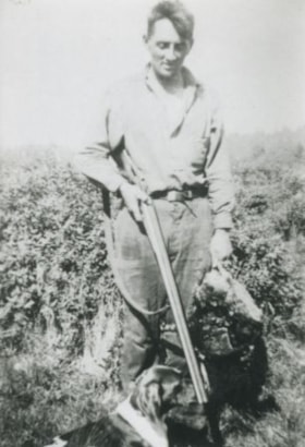
- Photograph of Arnold Rypdal his dog, Molly, with some type of game.
- Repository
- City of Burnaby Archives
- Date
- 1930 (date of original), copied 1992
- Collection/Fonds
- Burnaby Historical Society fonds
- Subseries
- Burnaby Centennial Anthology subseries
- Physical Description
- 1 photograph : b&w ; 8.7 x 12.6 cm print
- Description Level
- Item
- Record No.
- 315-304
- Access Restriction
- No restrictions
- Reproduction Restriction
- No known restrictions
- Accession Number
- BHS1994-04
- Scope and Content
- Photograph of Arnold Rypdal his dog, Molly, with some type of game.
- Names
- Rypdal, Arnold
- Media Type
- Photograph
- Notes
- Title based on contents of photograph
- Historic Neighbourhood
- Fraser Arm (Historic Neighbourhood)
- Planning Study Area
- Big Bend Area
Images

Bearn family
https://search.heritageburnaby.ca/link/archivedescription37072
- Repository
- City of Burnaby Archives
- Date
- 1923 (date of original), copied 1992
- Collection/Fonds
- Burnaby Historical Society fonds
- Description Level
- Item
- Physical Description
- 1 photograph : b&w ; 6.9 x 12.3 cm print
- Scope and Content
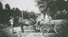
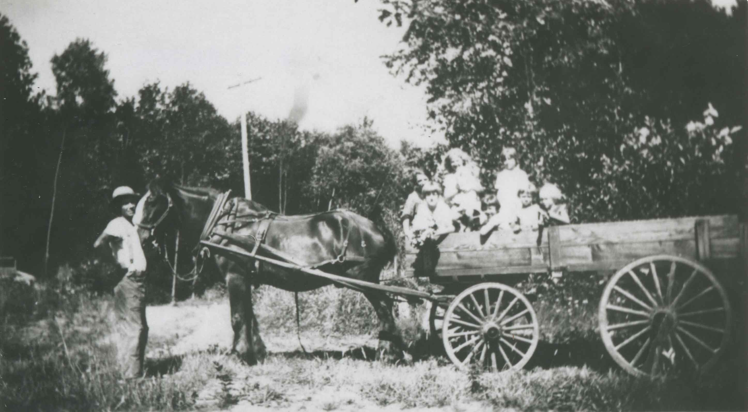
- Photograph of William "Bill" Bearn taking his children for wagon ride on Marine Drive. There were eight Bearn children: Ruth, Gladys, Doris, Helen, Jean, Audrey, William "Bud," and Shirley.
- Repository
- City of Burnaby Archives
- Date
- 1923 (date of original), copied 1992
- Collection/Fonds
- Burnaby Historical Society fonds
- Subseries
- Burnaby Centennial Anthology subseries
- Physical Description
- 1 photograph : b&w ; 6.9 x 12.3 cm print
- Description Level
- Item
- Record No.
- 315-535
- Access Restriction
- No restrictions
- Reproduction Restriction
- No known restrictions
- Accession Number
- BHS1994-04
- Scope and Content
- Photograph of William "Bill" Bearn taking his children for wagon ride on Marine Drive. There were eight Bearn children: Ruth, Gladys, Doris, Helen, Jean, Audrey, William "Bud," and Shirley.
- Names
- Christianson, Audrey Frances May Bearn
- Haddock, Doris Edna Bearn
- Law, Gladys Evangeline Bearn
- Solloway, Helen Beryl Bearn
- McGregor, Jean Phyllis
- Taylor, Shirley Bearn
- Bearn, William "Bill"
- Bearn, William "Bud"
- Whittacker, Ruth Bearn
- Media Type
- Photograph
- Notes
- Title based on contents of photograph
- Geographic Access
- Marine Drive
- Historic Neighbourhood
- Fraser Arm (Historic Neighbourhood)
- Planning Study Area
- Big Bend Area
Images

Bearn sisters
https://search.heritageburnaby.ca/link/archivedescription37076
- Repository
- City of Burnaby Archives
- Date
- 1926 (date of original), copied 1992
- Collection/Fonds
- Burnaby Historical Society fonds
- Description Level
- Item
- Physical Description
- 1 photograph : b&w ; 7.1 x 11.8 cm print
- Scope and Content
- Photograph of three of the daughters of William "Bill" and Lavinia Bearn in their mother's flower garden. Mrs. Bearn sold the flowers in her flower shop. Two of the girls are holding cats. There were seven daughters: Ruth, Gladys, Doris, Helen, Jean, Audrey, and Shirley.
- Repository
- City of Burnaby Archives
- Date
- 1926 (date of original), copied 1992
- Collection/Fonds
- Burnaby Historical Society fonds
- Subseries
- Burnaby Centennial Anthology subseries
- Physical Description
- 1 photograph : b&w ; 7.1 x 11.8 cm print
- Description Level
- Item
- Record No.
- 315-539
- Access Restriction
- No restrictions
- Reproduction Restriction
- No known restrictions
- Accession Number
- BHS1994-04
- Scope and Content
- Photograph of three of the daughters of William "Bill" and Lavinia Bearn in their mother's flower garden. Mrs. Bearn sold the flowers in her flower shop. Two of the girls are holding cats. There were seven daughters: Ruth, Gladys, Doris, Helen, Jean, Audrey, and Shirley.
- Subjects
- Animals - Cats
- Plants - Flowers
- Media Type
- Photograph
- Notes
- Title based on contents of photograph
- Geographic Access
- Marine Drive
- Boundary Road
- Historic Neighbourhood
- Fraser Arm (Historic Neighbourhood)
- Planning Study Area
- Big Bend Area
Images

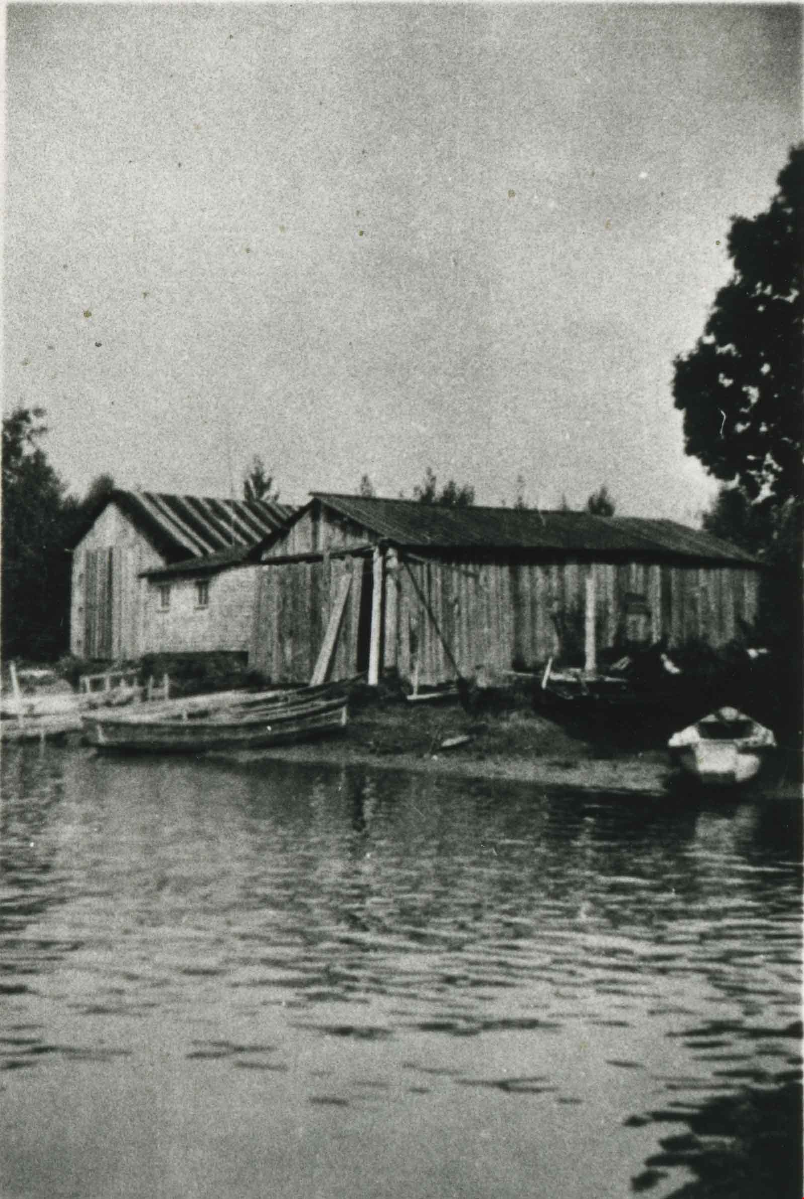
Boat sheds
https://search.heritageburnaby.ca/link/archivedescription35662
- Repository
- City of Burnaby Archives
- Date
- 1930 (date of original), copied 1986
- Collection/Fonds
- Burnaby Historical Society fonds
- Description Level
- Item
- Physical Description
- 1 photograph : b&w ; 12.7 x 17.8 cm print
- Scope and Content
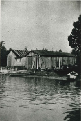
- Photograph of Burnaby salmon fleet boat sheds, between the foot of Sussex (if it continued to the water) and the foot of Byrne along the north arm of the Fraser River. JS 6554 is Joe Stacey's 30-foot gillnetter.
- Repository
- City of Burnaby Archives
- Date
- 1930 (date of original), copied 1986
- Collection/Fonds
- Burnaby Historical Society fonds
- Subseries
- Pioneer Tales subseries
- Physical Description
- 1 photograph : b&w ; 12.7 x 17.8 cm print
- Description Level
- Item
- Record No.
- 204-520
- Access Restriction
- No restrictions
- Reproduction Restriction
- No known restrictions
- Accession Number
- BHS1988-03
- Scope and Content
- Photograph of Burnaby salmon fleet boat sheds, between the foot of Sussex (if it continued to the water) and the foot of Byrne along the north arm of the Fraser River. JS 6554 is Joe Stacey's 30-foot gillnetter.
- Media Type
- Photograph
- Notes
- Title based on contents of photograph
- Geographic Access
- Burnaby Fraser Foreshore Park
- Historic Neighbourhood
- Fraser Arm (Historic Neighbourhood)
- Planning Study Area
- Big Bend Area
Images
![Boy standing at the fence, [1920] (date of original), copied 1986 thumbnail](/media/hpo/_Data/_Archives_Images/_Unrestricted/126/162-010.jpg?width=280)
Boy standing at the fence
https://search.heritageburnaby.ca/link/archivedescription34941
- Repository
- City of Burnaby Archives
- Date
- [1920] (date of original), copied 1986
- Collection/Fonds
- Burnaby Historical Society fonds
- Description Level
- Item
- Physical Description
- 1 photograph : b&w ; 12.5 x 8.8 cm print
- Scope and Content
- Photograph of a boy standing at a white picket fence holding onto a wheelbarrow alongside Marine Drive. The Unident house can be seen in the background.
- Repository
- City of Burnaby Archives
- Date
- [1920] (date of original), copied 1986
- Collection/Fonds
- Burnaby Historical Society fonds
- Subseries
- Photographs subseries
- Physical Description
- 1 photograph : b&w ; 12.5 x 8.8 cm print
- Description Level
- Item
- Record No.
- 162-010
- Access Restriction
- No restrictions
- Reproduction Restriction
- No known restrictions
- Accession Number
- BHS1986-13
- Scope and Content
- Photograph of a boy standing at a white picket fence holding onto a wheelbarrow alongside Marine Drive. The Unident house can be seen in the background.
- Media Type
- Photograph
- Notes
- Title based on contents of photograph
- Geographic Access
- Marine Drive
- Historic Neighbourhood
- Fraser Arm (Historic Neighbourhood)
- Planning Study Area
- Big Bend Area
Images
![Boy standing at the fence, [1920] (date of original), copied 1986 thumbnail](/media/hpo/_Data/_Archives_Images/_Unrestricted/126/162-010.jpg)
![Canadian National Railway Bridge, [between 1930 and 1934] (date of original), copied 1991 thumbnail](/media/hpo/_Data/_Archives_Images/_Unrestricted/370/370-059.jpg?width=280)
Canadian National Railway Bridge
https://search.heritageburnaby.ca/link/archivedescription37471
- Repository
- City of Burnaby Archives
- Date
- [between 1930 and 1934] (date of original), copied 1991
- Collection/Fonds
- Burnaby Historical Society fonds
- Description Level
- Item
- Physical Description
- 1 photograph : b&w ; 2.7 x 4.1 cm print on contact sheet 20.2 x 25.3 cm
- Scope and Content
- Photograph of the Canadian National Railway (CNR) Bridge over the Fraser River open to allow ships through. No boats are visible.
- Repository
- City of Burnaby Archives
- Date
- [between 1930 and 1934] (date of original), copied 1991
- Collection/Fonds
- Burnaby Historical Society fonds
- Subseries
- Burnaby Image Bank subseries
- Physical Description
- 1 photograph : b&w ; 2.7 x 4.1 cm print on contact sheet 20.2 x 25.3 cm
- Description Level
- Item
- Record No.
- 370-059
- Access Restriction
- No restrictions
- Reproduction Restriction
- No known restrictions
- Accession Number
- BHS1999-03
- Scope and Content
- Photograph of the Canadian National Railway (CNR) Bridge over the Fraser River open to allow ships through. No boats are visible.
- Media Type
- Photograph
- Photographer
- Bellinger, Bernard
- Notes
- Title based on contents of photograph
- 1 b&w copy negative accompanying
- Historic Neighbourhood
- Fraser Arm (Historic Neighbourhood)
- Planning Study Area
- Big Bend Area
Images
![Canadian National Railway Bridge, [between 1930 and 1934] (date of original), copied 1991 thumbnail](/media/hpo/_Data/_Archives_Images/_Unrestricted/370/370-059.jpg)
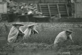
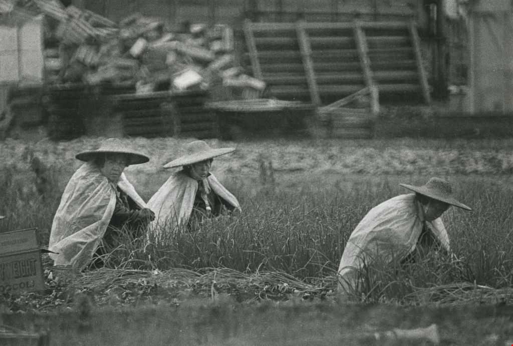
Farming in the rain
https://search.heritageburnaby.ca/link/archivedescription45325
- Repository
- City of Burnaby Archives
- Date
- July 13, 1981
- Collection/Fonds
- Columbian Newspaper collection
- Description Level
- Item
- Physical Description
- 1 photograph : b&w ; 15.5 x 22.5 cm
- Scope and Content
- Photograph of three farmers wearing straw hats and plastic shawls working in the rain in an onion field on the Burnaby flats near Meadow Street (now named Meadow Avenue).
- Repository
- City of Burnaby Archives
- Date
- July 13, 1981
- Collection/Fonds
- Columbian Newspaper collection
- Physical Description
- 1 photograph : b&w ; 15.5 x 22.5 cm
- Description Level
- Item
- Record No.
- 480-220
- Access Restriction
- No restrictions
- Reproduction Restriction
- No restrictions
- Accession Number
- 2003-02
- Scope and Content
- Photograph of three farmers wearing straw hats and plastic shawls working in the rain in an onion field on the Burnaby flats near Meadow Street (now named Meadow Avenue).
- Subjects
- Occupations - Farmers
- Media Type
- Photograph
- Photographer
- Battistoni, Peter
- Notes
- Title based on contents of photograph
- Newspaper clipping on verso of photograph reads: "WET WORK... Plastic sheets and broad straw hats protect field workers from the cool, wet elements at a farm on the Burnaby flats near Meadow Street this week. More seasonal weather, however, including rising temperatures and clearly [sic] skies, promises that life in the onion fields will be more tolerable, at least for the next little while."
- Geographic Access
- Meadow Avenue
- Historic Neighbourhood
- Fraser Arm (Historic Neighbourhood)
- Planning Study Area
- Big Bend Area
Images

Fire insurance key plan - Greater Vancouver - Volume XIX - Municipality of Burnaby
https://search.heritageburnaby.ca/link/museumdescription17799
- Repository
- Burnaby Village Museum
- Date
- 1927
- Collection/Fonds
- Burnaby Village Museum Map collection
- Description Level
- Item
- Physical Description
- 1 plan on 1 sheet : col. lithographic print ; 64 x 54 cm
- Scope and Content
- Item consists of a one page fire insurance key plan titled "Greater Vancouver / Volume XIX / Municipality / of Burnaby / Key Plan" surveyed May 1927. Key plan from compilation, "Insurance Plans of Greater Vancouver Plan No. 11, Volumes 15 to 19 Burnaby".
- Repository
- Burnaby Village Museum
- Collection/Fonds
- Burnaby Village Museum Map collection
- Description Level
- Item
- Physical Description
- 1 plan on 1 sheet : col. lithographic print ; 64 x 54 cm
- Material Details
- Scale [1:6000]
- Scope and Content
- Item consists of a one page fire insurance key plan titled "Greater Vancouver / Volume XIX / Municipality / of Burnaby / Key Plan" surveyed May 1927. Key plan from compilation, "Insurance Plans of Greater Vancouver Plan No. 11, Volumes 15 to 19 Burnaby".
- Publisher
- Plan Department of Fire Branch of British Columbia Underwriters' Association
- Accession Code
- BV987.1.70
- Access Restriction
- No restrictions
- Reproduction Restriction
- May be restricted by third party rights
- Date
- 1927
- Media Type
- Cartographic Material
- Historic Neighbourhood
- Fraser Arm (Historic Neighbourhood)
- Planning Study Area
- Big Bend Area
- Scan Resolution
- 400
- Scan Date
- 2021-11-17
- Notes
- Title based on contents of item
- Scale 500 feet = 1 inch
- These plans were removed from a bound book with labels on cover page reading: "Plan No. 90 / THIS INSURANCE PLAN / of / Vancouver VOLUME "8" / IN THE PROPERTY OF THE / British Columbia Insurance Underwriter's Association / Vancouver B.C. / AND IS LOANED / MELVILLE F. THOMSON CO. .../ Date May 26th, 1934"; / "Plan No. 74 / THIS INSURANCE PLAN / OF / VANCOUVER VOLUME "9"" / Plan No. 11 / THIS INSURANCE PLAN / OF / BURNABY VOLUMES 15-19" / "THIS PLAN IS THE PROPERTY OF / THE / BRITISH LAW INSURANCE COMPANY / LIMITED"
- Does not include the corresponding key plan page or associated plans numbered 1901 to 1914
- Contact Burnaby Village Museum to view associated fire insurance plans
Zoomable Images

Fire insurance key plan - Greater Vancouver - Volume XIX - Municipality of Burnaby, 1927
Zoom into Image![Fraser River, [1930] thumbnail](/media/hpo/_Data/_Archives_Images/_Unrestricted/126/160-001.jpg?width=280)
Fraser River
https://search.heritageburnaby.ca/link/archivedescription34922
- Repository
- City of Burnaby Archives
- Date
- [1930]
- Collection/Fonds
- Burnaby Historical Society fonds
- Description Level
- Item
- Physical Description
- 1 photograph : b&w ; 28.3 x 18.6 cm
- Scope and Content
- Photograph of squatters' shacks and fishing boats on the shore of the Fraser River at the foot of Byrne Road. The photograph was taken from a boat on the north arm of the Fraser River.
- Repository
- City of Burnaby Archives
- Date
- [1930]
- Collection/Fonds
- Burnaby Historical Society fonds
- Subseries
- Bernard Bellinger subseries
- Physical Description
- 1 photograph : b&w ; 28.3 x 18.6 cm
- Description Level
- Item
- Record No.
- 160-001
- Access Restriction
- No restrictions
- Reproduction Restriction
- No known restrictions
- Accession Number
- BHS1986-10
- Scope and Content
- Photograph of squatters' shacks and fishing boats on the shore of the Fraser River at the foot of Byrne Road. The photograph was taken from a boat on the north arm of the Fraser River.
- Media Type
- Photograph
- Notes
- Title based on contents of photograph
- Geographic Access
- Byrne Road
- Historic Neighbourhood
- Fraser Arm (Historic Neighbourhood)
- Planning Study Area
- Big Bend Area
Images
![Fraser River, [1930] thumbnail](/media/hpo/_Data/_Archives_Images/_Unrestricted/126/160-001.jpg)
![Fraser River, [1930] (date of original), copied 1986 thumbnail](/media/hpo/_Data/_Archives_Images/_Unrestricted/126/160-002.jpg?width=280)
Fraser River
https://search.heritageburnaby.ca/link/archivedescription34923
- Repository
- City of Burnaby Archives
- Date
- [1930] (date of original), copied 1986
- Collection/Fonds
- Burnaby Historical Society fonds
- Description Level
- Item
- Physical Description
- 1 photograph : b&w ; 8.5 x 5.5 cm print
- Scope and Content
- Photograph of squatters' shacks on the shore of the Fraser River at the foot of Byrne Road.
- Repository
- City of Burnaby Archives
- Date
- [1930] (date of original), copied 1986
- Collection/Fonds
- Burnaby Historical Society fonds
- Subseries
- Bernard Bellinger subseries
- Physical Description
- 1 photograph : b&w ; 8.5 x 5.5 cm print
- Description Level
- Item
- Record No.
- 160-002
- Access Restriction
- No restrictions
- Reproduction Restriction
- No known restrictions
- Accession Number
- BHS1986-10
- Scope and Content
- Photograph of squatters' shacks on the shore of the Fraser River at the foot of Byrne Road.
- Media Type
- Photograph
- Notes
- Title based on contents of photograph
- Geographic Access
- Byrne Road
- Historic Neighbourhood
- Fraser Arm (Historic Neighbourhood)
- Planning Study Area
- Big Bend Area
Images
![Fraser River, [1930] (date of original), copied 1986 thumbnail](/media/hpo/_Data/_Archives_Images/_Unrestricted/126/160-002.jpg)