Narrow Results By
Subject
- Agricultural Tools and Equipment 5
- Agriculture - Crops 8
- Agriculture - Farms 3
- Agriculture - Fruit and Berries 1
- Animals - Cats 4
- Animals - Cows 1
- Animals - Dogs 6
- Animals - Horses 15
- Building Components 1
- Buildings - Agricultural 3
- Buildings - Agricultural - Barns 2
- Buildings - Agricultural - Greenhouses 2

F.J. Hart Estate 'Avalon'
https://search.heritageburnaby.ca/link/landmark542
- Repository
- Burnaby Heritage Planning
- Description
- The F.J. Hart Estate, 'Avalon,' is comprised of 5.26 hectares of lakefront property now located within Deer Lake Park, an Arts and Crafts/Tudor Revival styled mansion and an associated later outbuilding. The mansion is now operated as the Hart House Restaurant.
- Associated Dates
- 1912
- Formal Recognition
- Heritage Designation, Community Heritage Register
- Other Names
- Hart House, Rosedale Gardens, Frederick John & Alice Hart Estate
- Street View URL
- Google Maps Street View
- Repository
- Burnaby Heritage Planning
- Other Names
- Hart House, Rosedale Gardens, Frederick John & Alice Hart Estate
- Geographic Access
- Deer Lake Avenue
- Associated Dates
- 1912
- Formal Recognition
- Heritage Designation, Community Heritage Register
- Enactment Type
- Bylaw No. 9807
- Enactment Date
- 23/11/1992
- Description
- The F.J. Hart Estate, 'Avalon,' is comprised of 5.26 hectares of lakefront property now located within Deer Lake Park, an Arts and Crafts/Tudor Revival styled mansion and an associated later outbuilding. The mansion is now operated as the Hart House Restaurant.
- Heritage Value
- 'Avalon' and its estate grounds are important as an illustration of the cultural, aesthetic, and lifestyle values of the wealthy families that settled in the Deer Lake area early in the twentieth century. These values were predominantly those of elegant country living and leisure pursuits. The estate is important for its connection with wealthy land developer Frederick John Hart (1868-1945), who was not only instrumental in the creation of subdivisions which promoted Deer Lake as an exclusive residential development for successful families in the New Westminster and Vancouver area, but was also an influential member of this new suburban community and of the emerging municipality of Burnaby. Hart had a wide range of business, civic, and political interests: his real-estate company managed many of the land sales in the area and numerous other large developments throughout the region; he was an entrepreneurial businessman associated with a number of companies important to the economic development of the area and British Columbia; and he was a 'public spirited citizen' and an alderman for the City of New Westminster. The architectural style of ‘Avalon’ set the tone for many of the grand mansions in the adjacent residential development - British Arts and Crafts in derivation, with eclectic details, particularly Tudor precedents. Designed for Hart and his wife Alice Chapman Hart (1867-1935) by Burnaby architect Frank William Macey (1863-1935), the use of references to Tudor England illustrates the relevance and importance to the residents of the area of a strong and visible connection with Britain. The first resident architect in Burnaby, Macey was born and trained in England where he was well-respected for having published two standard texts for the architectural profession. He settled in Burnaby in the first decade of the twentieth century and obtained a number of commissions from prominent businessmen who were building grand homes in the new community of Deer Lake. He designed mostly in the British Arts and Crafts style and introduced the use of rough-cast stucco for building exteriors, a characteristic for which he was renowned, and of which ‘Avalon’ is an excellent example.
- Defining Elements
- Key elements that define the heritage character of 'Avalon' include its: - estate in its entirety: house, grounds, landscape features and garage outbuilding - complex asymmetrical massing - side gable roof punctuated with massive cross gables at the front and rear and open gable ends - exterior features of the house such as the rough-cast stucco with mock-Tudor timbering; cobble-stone facings; square tower with mock battlements - multiple-assemblies of wooden-sash casement windows - tall, prominent corbelled brick chimneys - grand interior spaces and fittings: particularly the entrance hall with its carved stone fireplace; the main staircase; panelled wainscotting; Tudor-arched windows; and fireplaces with original tile surrounds
- Locality
- Deer Lake Park
- Historic Neighbourhood
- Burnaby Lake (Historic Neighbourhood)
- Planning Study Area
- Morley-Buckingham Area
- Architect
- Frank William Macey
- Function
- Primary Current--Eating or Drinking Establishment
- Primary Historic--Estate
- Community
- Burnaby
- Cadastral Identifier
- P.I.D. No. 002-764-431 Legal Description: Lot 6 Except: Firstly: Part on Reference Plan 14874 and Secondly: Part subdivided by Plan 77594, District Lot 85, Group 1, New Westminster District, Plan 11109
- Boundaries
- 'Avalon' is comprised of a single municipally-owned property located at 6664 Deer Lake Avenue, Burnaby.
- Area
- 18,792.29
- Contributing Resource
- Building
- Landscape Feature
- Ownership
- Public (local)
- Other Collection
- Burnaby Village Museum, Collection: Hart Photograph Albums
- Documentation
- Heritage Site Files: PC77000 20. City of Burnaby Planning and Building Department, 4949 Canada Way, Burnaby, B.C., V5G 1M2
- Street Address
- 6664 Deer Lake Avenue
- Street View URL
- Google Maps Street View
Images


H.T. Ceperley Estate 'Fairacres' Chauffeur's Cottage
https://search.heritageburnaby.ca/link/landmark529
- Repository
- Burnaby Heritage Planning
- Description
- Designed in the British Arts and Crafts style, the Chauffeur's Cottage is situated across from the main entrance to the Ceperley Mansion, and adjacent to the Garage and Stables. A long, narrow single-storey building, it was constructed by joining together two modest estate cottages.
- Associated Dates
- 1911
- Formal Recognition
- Heritage Designation, Community Heritage Register
- Repository
- Burnaby Heritage Planning
- Geographic Access
- Deer Lake Avenue
- Associated Dates
- 1911
- Formal Recognition
- Heritage Designation, Community Heritage Register
- Enactment Type
- Bylaw No. 9807
- Enactment Date
- 23/11/1992
- Description
- Designed in the British Arts and Crafts style, the Chauffeur's Cottage is situated across from the main entrance to the Ceperley Mansion, and adjacent to the Garage and Stables. A long, narrow single-storey building, it was constructed by joining together two modest estate cottages.
- Heritage Value
- The outbuildings at 'Fairacres' are a rare surviving architecturally designed ensemble of agricultural structures that exist in complementary harmony with the main estate house. Architect Robert Mackay Fripp (1858-1917) was retained by the Ceperleys to design several original outbuildings on their estate at the same time as the main house was constructed. The Chauffeur's Cottage illustrates the increasing importance of the automobile in the lives of the wealthy of the early twentieth century. It also demonstrates Grace and Henry Tracy Ceperley's social aspirations and grand-country-estate pretension in having a chauffeur. The cottage's location - close to the garage and convenient, but not adjacent, to the main house - enhances the grand country house landscape design and contributes to the overall composition of the estate's plan. The Arts and Crafts styled Chauffeur's Cottage is important as an indicator of the aesthetic and social sensibilities of the Ceperley family in retaining an architect to design a modest building for staff accommodation.
- Defining Elements
- Key elements that define the heritage character of the 'Fairacres' Chauffeur's Cottage include its: - location, in relation to the main house and in close proximity to the Garage and Stables buildings - side gable roof with cedar shingle cladding - Arts and Crafts architectural features such as the jerkin-headed door hood, a reference to the thatched-roofed cottages of southern England; eight-paned wooden-sash casement windows; and cedar-shingled exterior - two internal brick chimneys - modest, functional interior, with simple trim and lack of pretension
- Locality
- Deer Lake Park
- Historic Neighbourhood
- Burnaby Lake (Historic Neighbourhood)
- Planning Study Area
- Douglas-Gilpin Area
- Architect
- Robert Mackay Fripp
- Function
- Primary Historic--Outbuilding
- Community
- Burnaby
- Cadastral Identifier
- P.I.D. No. 004-493-311 Legal Description: Block 3 Except: Part subdivided by Plan 26865, District Lot 79, Group 1, New Westminster District, Plan 536
- Boundaries
- ‘Fairacres’ is comprised of a single municipally-owned property located at 6344 Deer Lake Avenue, Burnaby.
- Area
- 17,065.00
- Contributing Resource
- Building
- Landscape Feature
- Ownership
- Public (local)
- Other Collection
- Burnaby Historical Society, Community Archives: Ceperley Photograph Album Burnaby Village Museum, Collection: Chinese ‘Tiger Whiskey’ and opium bottles found during restoration
- Documentation
- Heritage Site Files: PC77000 20. City of Burnaby Planning and Building Department, 4949 Canada Way, Burnaby, B.C., V5G 1M2
- Street Address
- 6344 Deer Lake Avenue
Images


H.T. Ceperley Estate 'Fairacres' Estate Gate
https://search.heritageburnaby.ca/link/landmark863
- Repository
- Burnaby Heritage Planning
- Description
- The 'Fairacres Estate Gate' marks the location of one of the original driveway entrances to the estate.
- Associated Dates
- 1911
- Formal Recognition
- Heritage Designation, Community Heritage Register
- Street View URL
- Google Maps Street View
- Repository
- Burnaby Heritage Planning
- Geographic Access
- Deer Lake Avenue
- Associated Dates
- 1911
- Formal Recognition
- Heritage Designation, Community Heritage Register
- Enactment Type
- Bylaw No. 140665
- Enactment Date
- 23/11/1992
- Description
- The 'Fairacres Estate Gate' marks the location of one of the original driveway entrances to the estate.
- Heritage Value
- Fairacres was designed as a country estate with a working farm that included over 10 acres of productive berry and vegetable fields, with a large kitchen garden, a root house to store food, and greenhouses heated by steam. The agricultural potential ofthe Deer Lake area made it one of the first parts of the municipality to attract settlement. Construction of the Fairacres Estate represented a shift toward wealthy country estates over more modest farms, and the Ceperleys employed a large staff to manage the estate's agricultural production. Agricultural use of the estate continued when a Catholic order of Benedictine monks purchased the estate as part of the Priory of St. Joseph and the Seminary of Christ the King, and continued to farm the land until 1953. The overall architectural intention of the estate's architect was to reflect the ideals of the Arts & Crafts movement to showcase craftsmanship, and to incorporate high quality materials, including many local materials, such as wood and stone from the site. On the mansion exterior, the rustic style is seen in the use of natural materials such as cedar shingles and siding, cobblestone foundations and chimneys and the half-timbering in gable ends. The estate's remaining gate pillar features the same rustic field and cobblestones used on the mansion. The original estate driveway had two entrances constructed in 1910, each marked by a pair of entry gate pillars which supported iron gates. The main entrance gate pillars which marked the lower driveway and the east pillar of the upper entrance were demolished many years ago and the iron gates removed. A single gate pillar remains marking the upper driveway, adjacent to the Garage and Stables. This gate pillar is a significant site feature and incorporates cobble stone and a carved sandstone capstone.
- Defining Elements
- Key elements that define the heritage character of the ‘Fairacres Estate Gate' include: - setting in relation to the estate boundary and estate buildings - Cobble stone and sandstone construction, which represents a typical Arts and Crafts use of local materials, and matches the extensive use of cobblestone as chimneys and foundations on the Fairacres mansion, as well as the use of sandstone on the mansion's exterior.
- Locality
- Deer Lake Park
- Historic Neighbourhood
- Burnaby Lake (Historic Neighbourhood)
- Planning Study Area
- Douglas-Gilpin Area
- Function
- Primary Historic--Estate
- Community
- Burnaby
- Cadastral Identifier
- P.I.D. No. 004-493-311 Legal Description: Block 3 Except: Part subdivided by Plan 26865, District Lot 79, Group 1, New Westminster District, Plan 536
- Boundaries
- ‘Fairacres’ is comprised of a single municipally-owned property located at 6344 Deer Lake Avenue, Burnaby.
- Area
- 17,065.00
- Contributing Resource
- Landscape Feature
- Ownership
- Public (local)
- Other Collection
- Burnaby Historical Society, Community Archives: Ceperley Photograph Album
- Documentation
- Heritage Site Files: PC77000 20. City of Burnaby Planning and Building Department, 4949 Canada Way, Burnaby, B.C., V5G 1M2
- Subjects
- Structures - Fences
- Street Address
- 6344 Deer Lake Avenue
- Street View URL
- Google Maps Street View
Images


H.T. Ceperley Estate 'Fairacres' Garage & Stables
https://search.heritageburnaby.ca/link/landmark530
- Repository
- Burnaby Heritage Planning
- Description
- Designed in the British Arts and Crafts style, the ‘Fairacres’ Garage and Stables is a two-storey wood frame building located on the 'Fairacres' estate, situated to the north of the Chauffeur's Cottage; at the south end of the structure is a single vehicle garage and to the north are several stable…
- Associated Dates
- 1911
- Formal Recognition
- Heritage Designation, Community Heritage Register
- Street View URL
- Google Maps Street View
- Repository
- Burnaby Heritage Planning
- Geographic Access
- Deer Lake Avenue
- Associated Dates
- 1911
- Formal Recognition
- Heritage Designation, Community Heritage Register
- Enactment Type
- Bylaw No. 9807
- Enactment Date
- 23/11/1992
- Description
- Designed in the British Arts and Crafts style, the ‘Fairacres’ Garage and Stables is a two-storey wood frame building located on the 'Fairacres' estate, situated to the north of the Chauffeur's Cottage; at the south end of the structure is a single vehicle garage and to the north are several stables for carriage, riding, and draught horses, a coach house, and tack room; the upper floor was originally a hay loft.
- Heritage Value
- The outbuildings at 'Fairacres' are a rare surviving architecturally designed ensemble of agricultural structures that exist in complementary harmony with the main estate house. Architect Robert Mackay Fripp (1858-1917) was retained by the Ceperleys to design several original outbuildings on their estate at the same time as the main house was constructed. The Garage and Stables building is important as a record of its era when transportation modes were in transition and the horse-drawn carriage, while still in use, was giving way to the automobile. The relative spatial arrangements within the building are a valuable indication of the economy of space associated with the automobile, as compared to the horse. The extent of the stabling arrangements signifies not only the use of carriage horses but also the continued reliance on draught horses in farming activities in this era. As well, it is an indication of the fashionable nature of equestrianism for wealthy families during this time. The building is important as a demonstration of the aesthetics of the Ceperley family in having an architect-designed outbuilding and obtaining craftsmanship and materials of the highest quality for each structure on their estate.
- Defining Elements
- Key elements that define the heritage character of the 'Fairacres' Garage and Stables include its: - location within easy reach of the main house and in close proximity to the Chauffeur's Cottage - floor plan with the garage at one end, close to the Chauffeur's Cottage, and stables and equine facilities at the other - variety and complexity of the roofline, including gable wall dormers, gable-on-hip roof ends, and half-hip extensions - Arts and Crafts architectural features of the exterior such as the shingle wall cladding articulated with a chevron-patterned course of shingles at the first floor level; casement windows; and deep eaves with additional purlins to support the overhang - original stable doors with hand-made forged-iron door hardware - multi-paned wooden-sash windows, some retaining original wire glass
- Locality
- Deer Lake Park
- Historic Neighbourhood
- Burnaby Lake (Historic Neighbourhood)
- Planning Study Area
- Douglas-Gilpin Area
- Architect
- Robert Mackay Fripp
- Function
- Primary Historic--Outbuilding
- Community
- Burnaby
- Cadastral Identifier
- P.I.D. No. 004-493-311 Legal Description: Block 3 Except: Part subdivided by Plan 26865, District Lot 79, Group 1, New Westminster District, Plan 536
- Boundaries
- ‘Fairacres’ is comprised of a single municipally-owned property located at 6344 Deer Lake Avenue, Burnaby.
- Area
- 17,065.00
- Contributing Resource
- Building
- Landscape Feature
- Ownership
- Public (local)
- Other Collection
- Burnaby Historical Society, Community Archives: Ceperley Photograph Album
- Documentation
- Heritage Site Files: PC77000 20. City of Burnaby Planning and Building Department, 4949 Canada Way, Burnaby, B.C., V5G 1M2
- Street Address
- 6344 Deer Lake Avenue
- Street View URL
- Google Maps Street View
Images


H.T. Ceperley Estate 'Fairacres' Greenhouse Foundation Wall
https://search.heritageburnaby.ca/link/landmark862
- Repository
- Burnaby Heritage Planning
- Description
- The original rubble stone walls that formed the foundation for a greenhouses adjacent to the Steam Plant Building provided heat to several greenhouses on the estate propoerty. The Root House, which is to the north of the Greenhouse Foundation Wall, provided storage for the farm operation.
- Associated Dates
- 1908
- Formal Recognition
- Heritage Designation, Community Heritage Register
- Repository
- Burnaby Heritage Planning
- Geographic Access
- Deer Lake Avenue
- Associated Dates
- 1908
- Formal Recognition
- Heritage Designation, Community Heritage Register
- Enactment Type
- Bylaw No. 140665
- Enactment Date
- 23/11/1992
- Description
- The original rubble stone walls that formed the foundation for a greenhouses adjacent to the Steam Plant Building provided heat to several greenhouses on the estate propoerty. The Root House, which is to the north of the Greenhouse Foundation Wall, provided storage for the farm operation.
- Heritage Value
- The outbuildings at 'Fairacres' are a rare surviving architecturally-designed ensemble of agricultural structures that exist in complementary harmony with the main estate house. Architect Robert Mackay Fripp (1858-1917), an outspoken advocate of Arts and Crafts design, was retained by the Ceperleys to design several original outbuildings on their estate, which was designed as a country estate with a working farm that included over 10 acres of productive berry and vegetable fields, with a large kitchen garden, a root house to store food, an orchard, and greenhouses heated by steam. The agricultural potential of the Deer Lake area made it one of the first parts of the municipality to attract settlement. In 1909, the Ceperleys built three large greenhouses heated by an adjacent steam plant (Fairacres Steam Plant). The greenhouses featured granite foundation walls, including this one which remains intact. The Ceperleys employed a large staff to manage the estate's agricultural production, including Chinese farm labourers. Produce was grown for use at the estate, and for sale at local markets. Agricultural use of the estate continued when a Catholic order of Benedictine monks purchased the estate as part of the Priory of St. Joseph and the Seminary of Christ the King, and continued to farm the land until 1953.
- Defining Elements
- Key elements that define the heritage character of the ‘Fairacres’ Steam Plant Building include its: - overall spatial arrangement of the Greenhouse Foundation Wall in relation to the Steam Plant Building and the Root House - original rubble stone walls reflecting the Arts and Crafts design aesthetic of the estate buildings.
- Locality
- Deer Lake Park
- Historic Neighbourhood
- Burnaby Lake (Historic Neighbourhood)
- Planning Study Area
- Douglas-Gilpin Area
- Architect
- Robert Mackay Fripp
- Function
- Primary Historic--Outbuilding
- Community
- Burnaby
- Cadastral Identifier
- P.I.D. No. 004-493-311 Legal Description: Block 3 Except: Part subdivided by Plan 26865, District Lot 79, Group 1, New Westminster District, Plan 536
- Boundaries
- ‘Fairacres’ is comprised of a single municipally-owned property located at 6344 Deer Lake Avenue, Burnaby.
- Area
- 17,065.00
- Contributing Resource
- Landscape Feature
- Remains
- Ownership
- Public (local)
- Other Collection
- Burnaby Historical Society, Community Archives: Ceperley Photograph Album
- Documentation
- Heritage Site Files: PC77000 20. City of Burnaby Planning and Building Department, 4949 Canada Way, Burnaby, B.C., V5G 1M2
- Street Address
- 6344 Deer Lake Avenue
Images


H.T. Ceperley Estate 'Fairacres' Mansion
https://search.heritageburnaby.ca/link/landmark526
- Repository
- Burnaby Heritage Planning
- Description
- 'Fairacres' is a large, two-and-one-half storey estate house in the British Arts and Crafts style, located in Deer Lake Park, with four associated original outbuildings.
- Associated Dates
- 1911
- Formal Recognition
- Heritage Designation, Community Heritage Register
- Other Names
- Henry Tracy & Grace Ceperley Estate
- Burnaby Art Gallery
- Street View URL
- Google Maps Street View
- Repository
- Burnaby Heritage Planning
- Other Names
- Henry Tracy & Grace Ceperley Estate
- Burnaby Art Gallery
- Geographic Access
- Deer Lake Avenue
- Associated Dates
- 1911
- Formal Recognition
- Heritage Designation, Community Heritage Register
- Enactment Type
- Bylaw No. 9807
- Enactment Date
- 23/11/1992
- Description
- 'Fairacres' is a large, two-and-one-half storey estate house in the British Arts and Crafts style, located in Deer Lake Park, with four associated original outbuildings.
- Heritage Value
- 'Fairacres' is important as a record of the early years of Burnaby, specifically the Deer Lake area, as a place of tranquility and beautiful scenery in which the wealthy and successful in the burgeoning cities of New Westminster and Vancouver chose to retire or to make their family homes. The main house, which anchors in style and setting the outbuildings on the estate, demonstrates the social, cultural, and aesthetic values of local wealthy businessmen and women of the early twentieth century - values such as appreciation of architectural elegance and grand interior spaces, leisure and recreation, formal landscaped gardens and scenic views. Also important is the association with the English-born and trained architect Robert Mackay Fripp (1858-1917), as this was one of his grandest residential commissions. Steeped in the current architectural trends in Great Britain, Fripp designed this sprawling mansion in the Arts and Crafts style, reflected in the architectural detailing and proportions. The style was common at the time and was often used for estate mansions as a symbol of affluence and good, modern taste as well as an affinity for all things British. Quality is displayed inside and out in the finishes and materials, orchestrated by prominent local contractor, James Charles Allen, including imported English materials of specific value such as imported Medmenham tiles in the fireplace surrounds, one of the earliest documented use of these tiles outside the United Kingdom. Detailed features of the interior woodwork were carved by Scottish-born master wood carver George Selkirk Gibson (1867-1942), who was best known for his many commissions for prominent British Columbia architect Samuel Maclure. The outbuildings at 'Fairacres' are an important record of the functioning of a large estate of the time. The Garage and Stables and the Chauffeur’s Cottage accommodated the use of automobiles, horses and carriages, and in concert with the estate's location near the new British Columbia Electric Railway 'Burnaby Lake' interurban line, illustrate the evolving nature of regional transportation and the growing bedroom communities and estates made possible by increasing options for transportation. Other outbuildings accommodated the agricultural activities that helped support the Ceperley estate. The estate was conceived and funded by American-born Grace E. Dixon Ceperley (1863-1917), who had achieved significant wealth through a bequest from her brother-in-law, Vancouver pioneer Arthur Ferguson. Her husband, Henry Tracy Ceperley (1850-1929), also American-born, was a successful and well-respected businessman who made a significant contribution to the development of the City of Vancouver. The construction of 'Fairacres' spawned the transformation of the Deer Lake area from a farming community into a preferred location for elite suburban homes. 'Fairacres' is significant to the City of Burnaby as its first civic heritage conservation project. Acquired in 1966 for conversion to Burnaby’s first art gallery, it was dedicated in 1967 to mark Canada’s Centennial of Confederation.
- Defining Elements
- Key elements that define the heritage character of the ‘Fairacres’ mansion include its: - setting in relation to the gardens, its former market garden, and the vistas to Deer Lake and other grand homes in the area - side gable roof with prominent dormers and cedar shingle cladding - verandah across the eastern (garden) facade, with its view over the landscaped gardens and the distant mountains - porte cochere with its side steps for those arriving by automobile, and central raised step for those alighting from horse-drawn carriages - rich variety of exterior elements that demonstrate the typical Arts and Crafts use of local materials such as cobble stone chimneys and foundations, wide wooden siding and half-timbering - mixture of double-hung and casement wooden-sash windows, many with multi-paned sash - lavish interior spaces, designed for entertaining on a grand scale, including a billiard room with a beamed ceiling and an inglenook fireplace, and generous living and dining rooms arranged off a central hall - quality of the interior materials such as imported Medmenham tiles in fireplace surrounds, window hardware by Hope and Sons, and leaded stained glass - interior wood work including the staircase, and carvings by George Selkirk Gibson - remaining formal Edwardian garden landscape elements, including the cross-axial plan that reflects the relationship of the mansion to its 'outdoor rooms'
- Locality
- Deer Lake Park
- Historic Neighbourhood
- Burnaby Lake (Historic Neighbourhood)
- Planning Study Area
- Douglas-Gilpin Area
- Architect
- Robert Mackay Fripp
- Function
- Primary Current--Museum
- Primary Historic--Estate
- Community
- Burnaby
- Cadastral Identifier
- P.I.D. No. 004-493-311 Legal Description: Block 3 Except: Part subdivided by Plan 26865, District Lot 79, Group 1, New Westminster District, Plan 536
- Boundaries
- ‘Fairacres’ is comprised of a single municipally-owned property located at 6344 Deer Lake Avenue, Burnaby.
- Area
- 17,065.00
- Contributing Resource
- Building
- Landscape Feature
- Ownership
- Public (local)
- Other Collection
- City of Burnaby, Visual Art Collection: Original rendering by R.P.S. Twizell Burnaby Historical Society, Community Archives: Ceperley Photograph Album Burnaby Village Museum, Collection: Carved dining room panels by G.S. Gibson and other hardware items
- Documentation
- Heritage Site Files: PC77000 20. City of Burnaby Planning and Building Department, 4949 Canada Way, Burnaby, B.C., V5G 1M2
- Names
- Ceperley, Grace
- Ceperley, H.T.
- Fripp, Robert Mackay
- Allen, James Charles
- Gibson, George Selkirk
- Street Address
- 6344 Deer Lake Avenue
- Street View URL
- Google Maps Street View
Images


H.T. Ceperley Estate 'Fairacres' Root House
https://search.heritageburnaby.ca/link/landmark527
- Repository
- Burnaby Heritage Planning
- Description
- The ‘Fairacres’ Root House is a long, low one-storey masonry building, measuring 4.6 metres by 9.1 metres, with massively buttressed concrete walls and foundations. Built into sloping ground adjacent to the location of the former greenhouses, the surviving orchard and the kitchen entrance of the ma…
- Associated Dates
- 1908
- Formal Recognition
- Heritage Designation, Community Heritage Register
- Repository
- Burnaby Heritage Planning
- Geographic Access
- Deer Lake Avenue
- Associated Dates
- 1908
- Formal Recognition
- Heritage Designation, Community Heritage Register
- Enactment Type
- Bylaw No. 9807
- Enactment Date
- 23/11/1992
- Description
- The ‘Fairacres’ Root House is a long, low one-storey masonry building, measuring 4.6 metres by 9.1 metres, with massively buttressed concrete walls and foundations. Built into sloping ground adjacent to the location of the former greenhouses, the surviving orchard and the kitchen entrance of the main house, 'Fairacres,' this functional structure was used as a frost-free store for fruit and vegetables for the family's use.
- Heritage Value
- The outbuildings at 'Fairacres' are a rare surviving architecturally-designed ensemble of agricultural structures that exist in complementary harmony with the main estate house. Architect Robert Mackay Fripp (1858-1917), an outspoken advocate of Arts and Crafts design, was retained by the Ceperleys to design several original outbuildings on their estate. The Root House is important as a rare surviving, and exceptionally large, example of this building type in the Vancouver region. Unusual in the fact that an architect designed a building of such modest aspirations, it is also remarkable in its method of construction. The use of concrete as a structural material is one of the earliest in the region and extraordinary for its use on such a modest vernacular outbuilding; root cellars were typically built of loose stone. Built in 1908, the Root House was significantly altered in the 1960s and restored to its original design in 2000. The building is significant as an indicator of the market gardening activity in the area around Deer Lake and of the country-house self-sufficiency practiced by the Ceperley family. The Root House illustrates the cultural, aesthetic, and lifestyle values of the Ceperleys in constructing such a large building for storing their own produce.
- Defining Elements
- The outbuildings at 'Fairacres' are a rare surviving architecturally-designed ensemble of agricultural structures that exist in complementary harmony with the main estate house. Architect Robert Mackay Fripp (1858-1917), an outspoken advocate of Arts and Crafts design, was retained by the Ceperleys to design several original outbuildings on their estate. The Root House is important as a rare surviving, and exceptionally large, example of this building type in the Vancouver region. Unusual in the fact that an architect designed a building of such modest aspirations, it is also remarkable in its method of construction. The use of concrete as a structural material is one of the earliest in the region and extraordinary for its use on such a modest vernacular outbuilding; root cellars were typically built of loose stone. Built in 1908, the Root House was significantly altered in the 1960s and restored to its original design in 2000. The building is significant as an indicator of the market gardening activity in the area around Deer Lake and of the country-house self-sufficiency practiced by the Ceperley family. The Root House illustrates the cultural, aesthetic, and lifestyle values of the Ceperleys in constructing such a large building for storing their own produce.
- Locality
- Deer Lake Park
- Historic Neighbourhood
- Burnaby Lake (Historic Neighbourhood)
- Planning Study Area
- Douglas-Gilpin Area
- Architect
- Robert Mackay Fripp
- Function
- Primary Historic--Outbuilding
- Secondary Historic--Food Storage
- Community
- Burnaby
- Cadastral Identifier
- P.I.D. No. 004-493-311 Legal Description: Block 3 Except: Part subdivided by Plan 26865, District Lot 79, Group 1, New Westminster District, Plan 536
- Boundaries
- ‘Fairacres’ is comprised of a single municipally-owned property located at 6344 Deer Lake Avenue, Burnaby.
- Area
- 17,065.00
- Contributing Resource
- Building
- Landscape Feature
- Ownership
- Public (local)
- Other Collection
- Burnaby Historical Society, Community Archives: Ceperley Photograph Album
- Documentation
- Heritage Site Files: PC77000 20. City of Burnaby Planning and Building Department, 4949 Canada Way, Burnaby, B.C., V5G 1M2
- Street Address
- 6344 Deer Lake Avenue
Images


H.T. Ceperley Estate 'Fairacres' Steam Plant Building
https://search.heritageburnaby.ca/link/landmark528
- Repository
- Burnaby Heritage Planning
- Description
- Designed in the British Arts and Crafts style, the ‘Fairacres’ Steam Plant Buiding is a single-storey wood frame building with a gabled roof that originally housed the apparatus for climate control in the greenhouses, formerly located to its north. The original rubble stone walls that formed the fo…
- Associated Dates
- 1908
- Formal Recognition
- Heritage Designation, Community Heritage Register
- Repository
- Burnaby Heritage Planning
- Geographic Access
- Deer Lake Avenue
- Associated Dates
- 1908
- Formal Recognition
- Heritage Designation, Community Heritage Register
- Enactment Type
- Bylaw No. 9807
- Enactment Date
- 23/11/1992
- Description
- Designed in the British Arts and Crafts style, the ‘Fairacres’ Steam Plant Buiding is a single-storey wood frame building with a gabled roof that originally housed the apparatus for climate control in the greenhouses, formerly located to its north. The original rubble stone walls that formed the foundation for the greenhouses stand adjacent. The Steam Plant Building stands as a pendant to the Root House, which is to the north of the former greenhouses.
- Heritage Value
- The outbuildings at 'Fairacres' are a rare surviving architecturally-designed ensemble of agricultural structures that exist in complementary harmony with the main estate house. Architect Robert Mackay Fripp (1858-1917), an outspoken advocate of Arts and Crafts design, was retained by the Ceperleys to design several original outbuildings on their estate. The Ceperleys operated 'Fairacres' with staff, a farm manager and workers, including Chinese, to grow produce for themselves and for sale at local markets. The Steam Plant Building illustrates the market gardening activity of the area around Deer Lake and its importance to the Ceperley family, which valued a year-round supply of fresh fruit and vegetables for the kitchen and flowers for the house. It also illustrates the cultural and aesthetic values of the Ceperleys in retaining an architect to design a functional outbuilding using an accepted and contemporary architectural style. Built in 1908, the Steam Plant Building was significantly altered in the 1960s and restored to its original design in 2000.
- Defining Elements
- Key elements that define the heritage character of the ‘Fairacres’ Steam Plant Building include its: - overall spatial arrangement of the Steam Plant Building in relation to the former greenhouses and the Root House - side gable roof with cedar shingle cladding. - tall brick chimney indicitive of the building's original function. - distinctive Arts and Crafts architectural features such as the shingle wall cladding with decorative shingling under window sills, deep eaves, and pebble-dashed concrete foundation walls - six-paned wooden-sash casement windows - simple functional interior features - rubble stone walls that formed the foundation for the greenhouses
- Locality
- Deer Lake Park
- Historic Neighbourhood
- Burnaby Lake (Historic Neighbourhood)
- Planning Study Area
- Douglas-Gilpin Area
- Architect
- Robert Mackay Fripp
- Function
- Primary Historic--Outbuilding
- Community
- Burnaby
- Cadastral Identifier
- P.I.D. No. 004-493-311 Legal Description: Block 3 Except: Part subdivided by Plan 26865, District Lot 79, Group 1, New Westminster District, Plan 536
- Boundaries
- ‘Fairacres’ is comprised of a single municipally-owned property located at 6344 Deer Lake Avenue, Burnaby.
- Area
- 17,065.00
- Contributing Resource
- Building
- Landscape Feature
- Ownership
- Public (local)
- Other Collection
- Burnaby Historical Society, Community Archives: Ceperley Photograph Album
- Documentation
- Heritage Site Files: PC77000 20. City of Burnaby Planning and Building Department, 4949 Canada Way, Burnaby, B.C., V5G 1M2
- Street Address
- 6344 Deer Lake Avenue
Images


R.F. Anderson House
https://search.heritageburnaby.ca/link/landmark531
- Repository
- Burnaby Heritage Planning
- Description
- The R.F. Anderson House is a large, two-and-one-half storey Arts and Crafts style wood frame house, now located in Deer Lake Park, built as a family home and now used as institutional offices.
- Associated Dates
- 1912
- Formal Recognition
- Heritage Designation, Community Heritage Register
- Other Names
- Robert Fenwick & Bessie Anderson House, Anderson Residence
- Street View URL
- Google Maps Street View
- Repository
- Burnaby Heritage Planning
- Other Names
- Robert Fenwick & Bessie Anderson House, Anderson Residence
- Geographic Access
- Deer Lake Avenue
- Associated Dates
- 1912
- Formal Recognition
- Heritage Designation, Community Heritage Register
- Enactment Type
- Bylaw No. 9807
- Enactment Date
- 23/11/1992
- Description
- The R.F. Anderson House is a large, two-and-one-half storey Arts and Crafts style wood frame house, now located in Deer Lake Park, built as a family home and now used as institutional offices.
- Heritage Value
- The R.F. Anderson House contributes to the overall stylistic ambiance of the area and demonstrates that a range of architectural features can be read as a cohesive whole. Although designed primarily in the British Arts and Crafts genre, as were other residences around Deer Lake, it also displays some influences of the popular Craftsman style. It was constructed in the Deer Lake Crescent subdivision, which was originally promoted as an upper class neighbourhood. It represents one of the first residential developments in the City of Burnaby that required buildings to be of a specific value, thus demonstrating the desire for exclusivity among the successful businessmen who chose to settle in the area. The house and grounds illustrate the social, cultural, lifestyle and leisure sensibilities of a successful local businessman and his family in the early twentieth century; Anderson was a New Westminster hardware merchant and Justice of the Peace. The development of the house and grounds within a controlled suburban context also illustrate the values of the owners in the Deer Lake Crescent subdivision, such as social aspiration, racial exclusivity, demonstration of architectural taste, importance of a landscaped garden, and the provision of facilities for fashionable leisure pursuits such as lawn tennis. The estate makes an important contribution to the residential grouping now preserved within Deer Lake Park, and demonstrates the broad social mix of those who chose to live in the area at a time when it was in transition from a market gardening area to a more exclusive residential community. The R.F. Anderson House is important for its association with local architect Frank William Macey (1863-1935), the first resident architect in Burnaby. Macey was born and trained in England where he was well-respected for having published two standard texts for the architectural profession. He settled in Burnaby in the first decade of the twentieth century and obtained a number of commissions from prominent businessmen who were building grand homes in the new community of Deer Lake. He designed these houses mostly in the British Arts and Crafts style.
- Defining Elements
- Key elements that define the heritage character of the R.F. Anderson House include its: - location within a park setting in relation to the W.J. Mathers House - irregular massing of the exterior and its cladding of drop-siding, with half-timbering and rough-cast stucco in the gables - picturesque irregular roofline, including an alteration in pitch over the front verandah, with cedar shingle cladding - interior plan with its generous entrance hall, staircase, and massive staircase window with leaded-lights - multiple-assembly wooden-sash casement windows - quality of interior features such as the Douglas Fir woodwork (some with original varnish finish); original hardware supplied by Anderson's hardware company; and original fireplaces with ornate tile surrounds - setting with the imprint of the lawn tennis court, now a garden terrace, and some of the original plantings
- Locality
- Deer Lake Park
- Historic Neighbourhood
- Burnaby Lake (Historic Neighbourhood)
- Planning Study Area
- Douglas-Gilpin Area
- Architect
- Frank William Macey
- Function
- Primary Current--Government Office
- Primary Historic--Single Dwelling
- Community
- Burnaby
- Cadastral Identifier
- P.I.D. No. 007-525-931 Legal Description: North 225 feet Lot 'C', District Lot 79, Group 1, New Westminster District, Plan 6884
- Boundaries
- The R.F. Anderson House is comprised of a single municipally-owned property located at 6450 Deer Lake Avenue, Burnaby.
- Area
- 63,100.00
- Contributing Resource
- Building
- Landscape Feature
- Ownership
- Public (local)
- Documentation
- Heritage Site Files: PC77000 20. City of Burnaby Planning and Building Department, 4949 Canada Way, Burnaby, B.C., V5G 1M2
- Names
- Macey, Frank W.
- Street Address
- 6450 Deer Lake Avenue
- Street View URL
- Google Maps Street View
Images


Thomas Irvine House
https://search.heritageburnaby.ca/link/landmark536
- Repository
- Burnaby Heritage Planning
- Description
- The Thomas Irvine House is a very small, two room wood frame cottage, originally located on Laurel Street in Central Burnaby (now the site of the Burnaby Lake Sports Complex - West), and now relocated to the Burnaby Village Museum.
- Associated Dates
- 1911
- Formal Recognition
- Heritage Designation, Community Heritage Register
- Other Names
- Tommy Irvine House
- Repository
- Burnaby Heritage Planning
- Other Names
- Tommy Irvine House
- Geographic Access
- Deer Lake Avenue
- Associated Dates
- 1911
- Formal Recognition
- Heritage Designation, Community Heritage Register
- Enactment Type
- Bylaw No. 9807
- Enactment Date
- 23/11/1992
- Description
- The Thomas Irvine House is a very small, two room wood frame cottage, originally located on Laurel Street in Central Burnaby (now the site of the Burnaby Lake Sports Complex - West), and now relocated to the Burnaby Village Museum.
- Heritage Value
- The Thomas Irvine House is representative of an extremely modest, vernacular working-class cottage of the early twentieth century, once common but mostly now demolished. Irish-born Thomas Irvine (1864-1964) and his friend, Robert Moore, constructed the house in 1911 to suit the simple needs of a bachelor. Irvine worked on the construction of the British Columbia Electric Railway Burnaby Lake Interurban Line and was a pile driver by trade. The house consists of two rooms, a living room/kitchen and a bedroom. There were some improvements made throughout the fifty years Irvine lived there, such as running water in 1929, and electricity in the 1950s, but the essential character and form of the house remained intact. Irvine was a well-known local character and pioneer of Burnaby. The heritage value for this house also lies in its interpretive value within the Burnaby Village Museum. The site is an important cultural feature for the interpretation of Burnaby’s heritage to the public. The Thomas Irvine House was moved to the Burnaby Village Museum in 1975 and was restored to its 1920s appearance.
- Defining Elements
- The character defining elements of the Thomas Irvine House include its: - rectangular form and simple massing - bellcast hipped form with cedar shingle cladding - cedar shingle cladding stained dark brown - double-hung 1-over-1 wooden-sash window on front facade; simple double wooden-sash casement on west facade - interior layout of the house with 2 rooms, a living room/kitchen and bedroom - V-joint tongue-and-groove wood interior paneling
- Locality
- Deer Lake Park
- Historic Neighbourhood
- Burnaby Lake (Historic Neighbourhood)
- Planning Study Area
- Morley-Buckingham Area
- Organization
- British Columbia Electric Railway
- Burnaby Village Museum
- Builder
- Thomas Irvine (Owner)
- Robert Moore
- Function
- Primary Current--Museum
- Primary Historic--Single Dwelling
- Community
- Burnaby
- Cadastral Identifier
- P.I.D. No. 011-030-356 Legal Description: Parcel 1, District Lot 79 and District Lot 85, Group 1, New Westminster District, Reference Plan 77594
- Boundaries
- Burnaby Village Museum is comprised of a single municipally-owned property located at 6501 Deer Lake Avenue, Burnaby.
- Area
- 38,488.63
- Contributing Resource
- Building
- Landscape Feature
- Structure
- Ownership
- Public (local)
- Documentation
- Heritage Site Files: PC77000 20. City of Burnaby Planning and Building Department, 4949 Canada Way, Burnaby, B.C., V5G 1M2
- Names
- Irvine, Tom
- Street Address
- 6501 Deer Lake Avenue
Images


Vorce Station
https://search.heritageburnaby.ca/link/landmark664
- Repository
- Burnaby Heritage Planning
- Description
- The Vorce Station is a modest utilitarian passenger tram shelter, originally constructed at the foot of Nursery Street as part of the British Columbia Electric Railway Company’s Burnaby Lake Interurban Line. In 1953, it was moved to a local farm by the Lubbock family, and in 1977 it was relocated t…
- Associated Dates
- 1911
- Formal Recognition
- Heritage Designation, Community Heritage Register
- Repository
- Burnaby Heritage Planning
- Geographic Access
- Deer Lake Avenue
- Associated Dates
- 1911
- Formal Recognition
- Heritage Designation, Community Heritage Register
- Enactment Type
- Bylaw No. 9807
- Enactment Date
- 23/11/1992
- Description
- The Vorce Station is a modest utilitarian passenger tram shelter, originally constructed at the foot of Nursery Street as part of the British Columbia Electric Railway Company’s Burnaby Lake Interurban Line. In 1953, it was moved to a local farm by the Lubbock family, and in 1977 it was relocated to Burnaby Village Museum. The wood-frame structure has a rectangular plan and hipped roof. It is enclosed on three sides, with an open side for access to the train platform and a single long built-in bench across the back of the station.
- Heritage Value
- The heritage value of the Vorce Station is as the last remaining interurban station in Burnaby and one of the few extant structures left in the Greater Vancouver region that were once part of the extensive British Columbia Electric Railway (BCER) interurban system. The Vorce Station was designed and built by the BCER, and is typical of the small local passenger stations on the Burnaby Lake and Chilliwack interurban lines. It was named after C.B. Vorce, the Chief Engineer for the company. The impact of the interurban line on local development was extremely significant, as it connected the cities of New Westminster and Vancouver, and enabled the residents of Burnaby to form a cohesive municipality from the mainly rural lands remaining between the two larger centres. Much of the early development in Burnaby was due to the growth of the interurban rail lines. The heritage significance for this station also lies in its interpretive value within the Burnaby Village Museum. The Vorce Station is an important cultural feature for the interpretation of Burnaby’s transportation history to the public, and is an important surviving feature of the BCER interurban system.
- Defining Elements
- The character defining features of the Vorce Station include its: - rectangular form and pyramidal roof with overhanging eaves - simple vernacular design and utilitarian nature - cedar shingle wall cladding - cedar shingle-clad roof with galvanized pressed tin roof ridges - interior vertical tongue-and-groove panelling - heritage graffiti: initials and messages carved and scrawled on the walls - identifying sign with large letters visible at a distance
- Locality
- Deer Lake Park
- Historic Neighbourhood
- Burnaby Lake (Historic Neighbourhood)
- Planning Study Area
- Morley-Buckingham Area
- Organization
- British Columbia Electric Railway
- Burnaby Village Museum
- Function
- Primary Current--Museum
- Primary Historic--Rail Station
- Community
- Burnaby
- Cadastral Identifier
- P.I.D. No. 011-030-356 Legal Description: Parcel 1, District Lot 79 and District Lot 85, Group 1, New Westminster District, Reference Plan 77594
- Boundaries
- Burnaby Village Museum is comprised of a single municipally-owned property located at 6501 Deer Lake Avenue, Burnaby.
- Area
- 38,488.63
- Contributing Resource
- Building
- Structure
- Landscape Feature
- Documentation
- Heritage Site Files: PC77000 20. City of Burnaby Planning and Building Department, 4949 Canada Way, Burnaby, B.C., V5G 1M2
- Street Address
- 6501 Deer Lake Avenue
Images


W.J. Mathers House 'Altnadene'
https://search.heritageburnaby.ca/link/landmark532
- Repository
- Burnaby Heritage Planning
- Description
- The W.J. Mathers House 'Altnadene', is a two-and-one-half storey wood frame house set in a large terraced garden, now located in Deer Lake Park. Built as a family home, it is designed in the British Arts and Crafts style enriched by Tudor, Romanesque, and medieval details.
- Associated Dates
- 1912
- Formal Recognition
- Heritage Designation, Community Heritage Register
- Other Names
- William & Mary Mathers Residence
- Street View URL
- Google Maps Street View
- Repository
- Burnaby Heritage Planning
- Other Names
- William & Mary Mathers Residence
- Geographic Access
- Deer Lake Avenue
- Associated Dates
- 1912
- Formal Recognition
- Heritage Designation, Community Heritage Register
- Enactment Type
- Bylaw No. 9807
- Enactment Date
- 23/11/1992
- Description
- The W.J. Mathers House 'Altnadene', is a two-and-one-half storey wood frame house set in a large terraced garden, now located in Deer Lake Park. Built as a family home, it is designed in the British Arts and Crafts style enriched by Tudor, Romanesque, and medieval details.
- Heritage Value
- 'Altnadene' was constructed in the Deer Lake Crescent subdivision, which was originally promoted as an upper class neighbourhood. It represents one of the first residential developments in the City of Burnaby that required buildings to be of a specific value, thus demonstrating the desire for exclusivity among the successful businessmen who chose to settle in the area. The house and grounds illustrate the social, cultural, lifestyle and leisure sensibilities of the owners in the Deer Lake Crescent subdivision: such values as social aspiration, racial exclusivity, demonstration of architectural taste, importance of a landscaped garden, and the provision of facilities for fashionable pursuits such as lawn tennis. The estate is historically significant for its connection to William John Mathers (1859-1929), an early pioneer who arrived in New Westminster in 1876, an enterprising grain dealer, businessman, alderman, president of the Board of Trade and various other local organizations, and a 'public spirited and progressive citizen.' Designed for Mathers and his wife, Mary Elizabeth Jane (Whelan) Mathers (1869-1939), by Burnaby architect Frank William Macey (1863-1935), the Arts and Crafts style of the Mathers House contributes to the overall stylistic ambiance of the collection of homes now preserved in Deer Lake Park, displaying an eclectic array of details that give it a unique identity. The first resident architect in Burnaby, Macey was born and trained in England where he was well-respected for having published two standard texts for the architectural profession. He settled in Burnaby in the first decade of the twentieth century and obtained a number of commissions from prominent businessmen who were building grand homes in the new community of Deer Lake. He designed mostly in the British Arts and Crafts style and introduced the use of rough-cast stucco for building exteriors, a characteristic for which he was renowned. The house also has an important connection to Burnaby’s history as it later served as a convalescent home for soldiers wounded on the battlefront during the First World War. Indicative of the evolving functionality of the site, a classroom wing was added in 1939 after Benedictine Monks acquired the house and it was operated as the Seminary of Christ the King.
- Defining Elements
- Key elements that define the heritage character of 'Altnadene' include its: - prominent corner location within a park setting, in relation to the Anderson residence - irregular form and massing - irregular roof line, including a central pyramidal hipped section and open gable ends to front and sides, with cedar shingle cladding - exterior of rough-cast stucco and half-timbering - eclectic exterior details such as the Tudor arches of the verandah; and the medieval crenellations of the tower - mixture of double-hung and casement, with transom, wooden-sash windows - massive chimneys of Clayburn firebrick - surviving interior details such as fireplaces, doors and leaded glass - wrought iron gates, massive gate-posts inscribed with 'Altnadene' and granite walls at the corner entry of the property
- Locality
- Deer Lake Park
- Historic Neighbourhood
- Burnaby Lake (Historic Neighbourhood)
- Planning Study Area
- Douglas-Gilpin Area
- Function
- Primary Current--Recreation Centre
- Primary Historic--Estate
- Community
- Burnaby
- Cadastral Identifier
- P.I.D. No. 007-527-241 Legal Description: Lot 'B', District Lot 79, Group 1, New Westminster District, Plan 6642
- Boundaries
- 'Altnadene' is comprised of a single municipally-owned property located at 6490 Deer Lake Avenue, Burnaby.
- Area
- 17,065.00
- Contributing Resource
- Building
- Landscape Feature
- Ownership
- Public (local)
- Other Collection
- City of Burnaby: Salvaged original elements from the house, including fireplace surrounds, doors and hardware
- Street Address
- 6490 Deer Lake Avenue
- Street View URL
- Google Maps Street View
Images


W.J. Mathers House 'Altnadene' Gate & Wall
https://search.heritageburnaby.ca/link/landmark858
- Repository
- Burnaby Heritage Planning
- Description
- The gate and wall of the W.J. Mathers House 'Altnadene' form an integral part of the heritage character of this historic estate, which includes a two-and-one-half storey wood frame house set in a large terraced garden, now located in Deer Lake Park. Built as a family home, it is designed in the Bri…
- Associated Dates
- 1912
- Formal Recognition
- Heritage Designation, Community Heritage Register
- Other Names
- William & Mary Mathers Residence
- Street View URL
- Google Maps Street View
- Repository
- Burnaby Heritage Planning
- Other Names
- William & Mary Mathers Residence
- Geographic Access
- Deer Lake Avenue
- Associated Dates
- 1912
- Formal Recognition
- Heritage Designation, Community Heritage Register
- Enactment Type
- Bylaw No. 13196
- Enactment Date
- 13/05/2013
- Description
- The gate and wall of the W.J. Mathers House 'Altnadene' form an integral part of the heritage character of this historic estate, which includes a two-and-one-half storey wood frame house set in a large terraced garden, now located in Deer Lake Park. Built as a family home, it is designed in the British Arts and Crafts style enriched by Tudor, Romanesque, and medieval details.
- Heritage Value
- 'Altnadene' was constructed in the Deer Lake Crescent subdivision, which was originally promoted as an upper class neighbourhood. It represents one of the first residential developments in the City of Burnaby that required buildings to be of a specific value, thus demonstrating the desire for exclusivity among the successful businessmen who chose to settle in the area. The house and grounds illustrate the social, cultural, lifestyle and leisure sensibilities of the owners in the Deer Lake Crescent subdivision: such values as social aspiration, racial exclusivity, demonstration of architectural taste, importance of a landscaped garden, and the provision of facilities for fashionable pursuits such as lawn tennis. The estate is historically significant for its connection to William John Mathers (1859-1929), an early pioneer who arrived in New Westminster in 1876, an enterprising grain dealer, businessman, alderman, president of the Board of Trade and various other local organizations, and a 'public spirited and progressive citizen.' The landscape of the estate featured a landmark granite capstone wall and wrought iron gate surrounding the front garden and terraced lawns of the mansion. The overall architectural intention was to reference medieval English estates by surrounding the ‘castle’ with a stone wall with gated entrances. The stone material for the construction of the wall was quarried from large ‘glacial erratic’ granite boulders found on the property. The highly decorative wrought iron gate was designed and made by artisan James A. Blair, a Scottish blacksmith employed by the Westminster Iron Works in 1912. The design for the 'double' driveway gate was featured in the company’s original catalogue as 'Design No. 152'. These gates are a very unusual and rare example of their type and are some of the most elaborate surviving examples in the City.
- Defining Elements
- Key elements that define the heritage character of the gate and wall at 'Altnadene' include its: - wrought iron gates, massive gate-posts inscribed with 'Altnadene' and granite walls at the corner entry of the property
- Locality
- Deer Lake Park
- Historic Neighbourhood
- Burnaby Lake (Historic Neighbourhood)
- Planning Study Area
- Douglas-Gilpin Area
- Organization
- Westminster Iron Works
- Function
- Primary Current--Recreation Centre
- Primary Historic--Estate
- Community
- Burnaby
- Cadastral Identifier
- P.I.D. No. 007-527-241 Legal Description: Lot 'B', District Lot 79, Group 1, New Westminster District, Plan 6642
- Boundaries
- 'Altnadene' is comprised of a single municipally-owned property located at 6490 Deer Lake Avenue, Burnaby.
- Area
- 17,065.00
- Contributing Resource
- Landscape Feature
- Ownership
- Public (local)
- Street Address
- 6490 Deer Lake Avenue
- Street View URL
- Google Maps Street View
Images


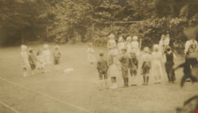
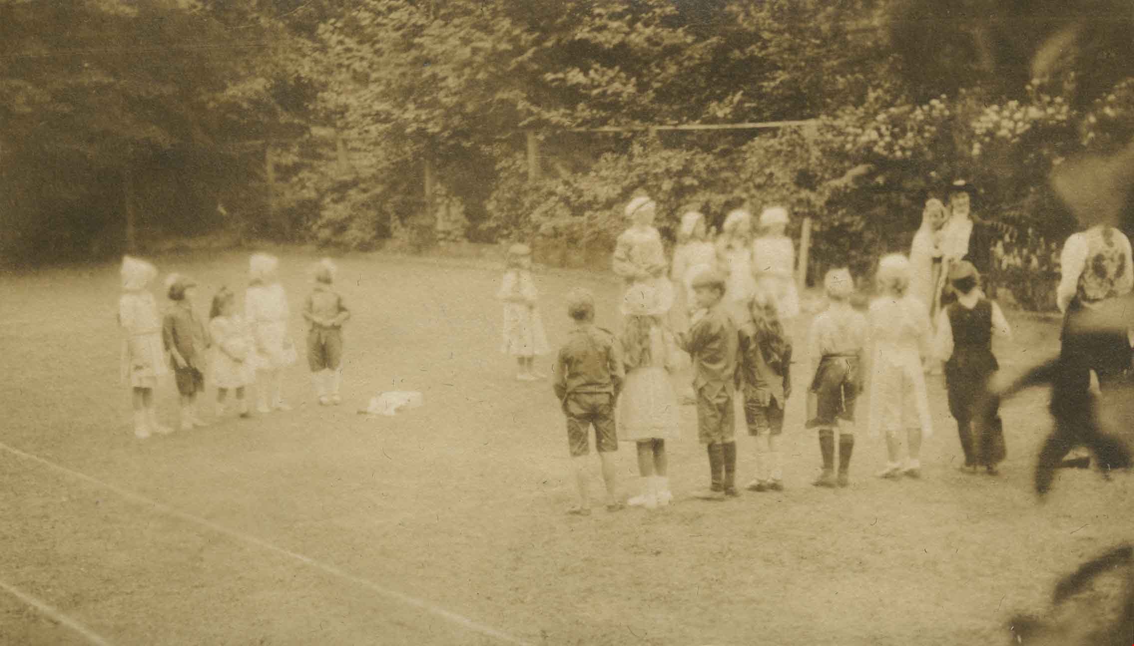
Alice in Wonderland party
https://search.heritageburnaby.ca/link/archivedescription38887
- Repository
- City of Burnaby Archives
- Date
- 1912
- Collection/Fonds
- Peers Family and Hill Family fonds
- Description Level
- Item
- Physical Description
- 1 photograph : sepia ; 5.5 x 9.7 cm on page 14 x 17.5 cm (pasted in album)
- Scope and Content
- Photograph of children enjoying an Alice in Wonderland party held as part of the St. Alban's Strawberry Social, 1912. The children are playing a game on the lawn at the Hart House, the estate belonging to Frederick J. Hart in the Burnaby Lake area.
- Repository
- City of Burnaby Archives
- Date
- 1912
- Collection/Fonds
- Peers Family and Hill Family fonds
- Physical Description
- 1 photograph : sepia ; 5.5 x 9.7 cm on page 14 x 17.5 cm (pasted in album)
- Description Level
- Item
- Record No.
- 477-206
- Access Restriction
- No restrictions
- Reproduction Restriction
- No known restrictions
- Accession Number
- 2007-12
- Scope and Content
- Photograph of children enjoying an Alice in Wonderland party held as part of the St. Alban's Strawberry Social, 1912. The children are playing a game on the lawn at the Hart House, the estate belonging to Frederick J. Hart in the Burnaby Lake area.
- Subjects
- Clothing - Costumes
- Events - Parties
- Media Type
- Photograph
- Notes
- Title based on caption accompanying photograph
- Geographic Access
- Deer Lake Avenue
- Street Address
- 6664 Deer Lake Avenue
- Historic Neighbourhood
- Burnaby Lake (Historic Neighbourhood)
- Planning Study Area
- Morley-Buckingham Area
Images
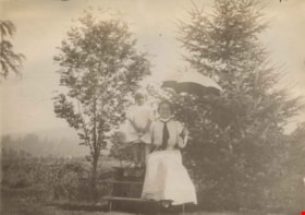
Annie and Kitty at Brookfield
https://search.heritageburnaby.ca/link/archivedescription39557
- Repository
- City of Burnaby Archives
- Date
- 1902
- Collection/Fonds
- Peers Family and Hill Family fonds
- Description Level
- Item
- Physical Description
- 1 photograph : b&w ; 7.5 x 10.5 cm on page 21.5 x 28 cm (pasted in album)
- Scope and Content
- Photograph of Annie Hill and her daughter Kitty on a picnic table in front of two trees. Annie is holding an umbrella. This photograph was probably taken at the Hill family home known as Brookfield, which was located on Deer Lake Avenue. A road (possibly Douglas Road) is partially visible in the b…
- Repository
- City of Burnaby Archives
- Date
- 1902
- Collection/Fonds
- Peers Family and Hill Family fonds
- Physical Description
- 1 photograph : b&w ; 7.5 x 10.5 cm on page 21.5 x 28 cm (pasted in album)
- Description Level
- Item
- Record No.
- 477-876
- Access Restriction
- No restrictions
- Reproduction Restriction
- No known restrictions
- Accession Number
- 2007-12
- Scope and Content
- Photograph of Annie Hill and her daughter Kitty on a picnic table in front of two trees. Annie is holding an umbrella. This photograph was probably taken at the Hill family home known as Brookfield, which was located on Deer Lake Avenue. A road (possibly Douglas Road) is partially visible in the background.
- Media Type
- Photograph
- Notes
- Title based on contents of photograph
- Geographic Access
- Deer Lake Avenue
- Street Address
- 6501 Deer Lake Avenue
- Historic Neighbourhood
- Burnaby Lake (Historic Neighbourhood)
- Planning Study Area
- Morley-Buckingham Area
Images

![Avalon, [1906] (date of original), copied 1986 thumbnail](/media/hpo/_Data/_Archives_Images/_Unrestricted/204/204-785.jpg?width=280)
Avalon
https://search.heritageburnaby.ca/link/archivedescription35925
- Repository
- City of Burnaby Archives
- Date
- [1906] (date of original), copied 1986
- Collection/Fonds
- Burnaby Historical Society fonds
- Description Level
- Item
- Physical Description
- 1 photograph : b&w ; 12.7 x 17.8 cm print
- Scope and Content
- Photograph of three people and a dog standing in front of the Hart family cottage on Deer Lake.
- Repository
- City of Burnaby Archives
- Date
- [1906] (date of original), copied 1986
- Collection/Fonds
- Burnaby Historical Society fonds
- Subseries
- Pioneer Tales subseries
- Physical Description
- 1 photograph : b&w ; 12.7 x 17.8 cm print
- Description Level
- Item
- Record No.
- 204-785
- Access Restriction
- No restrictions
- Reproduction Restriction
- No known restrictions
- Accession Number
- BHS1988-03
- Scope and Content
- Photograph of three people and a dog standing in front of the Hart family cottage on Deer Lake.
- Media Type
- Photograph
- Notes
- Title based on contents of photograph
- Geographic Access
- Deer Lake
- Deer Lake Avenue
- Street Address
- 6664 Deer Lake Avenue
- Historic Neighbourhood
- Burnaby Lake (Historic Neighbourhood)
- Planning Study Area
- Morley-Buckingham Area
Images
![Avalon, [1906] (date of original), copied 1986 thumbnail](/media/hpo/_Data/_Archives_Images/_Unrestricted/204/204-785.jpg)
![Brookfield, [1900] thumbnail](/media/hpo/_Data/_BVM_Images/1976/1976_0139_0005_001.jpg?width=280)
Brookfield
https://search.heritageburnaby.ca/link/museumdescription754
- Repository
- Burnaby Village Museum
- Date
- [1900]
- Collection/Fonds
- Burnaby Village Museum Photograph collection
- Description Level
- Item
- Physical Description
- 1 photograph : b&w ; 9.9 x 14.0 cm mounted on cardboard 17.8 x 23.0 cm
- Scope and Content
- Photograph of "Brookfield", the first home of Mr. and Mrs. Louis Claude Hill. The Hills, including the daughter Kitty Hill, are on the lawn on the lower right corner. The man sitting on the steps is identified by the inscription on the photograph card mount as Mr. Wetenhall. Annotations on the back…
- Repository
- Burnaby Village Museum
- Collection/Fonds
- Burnaby Village Museum Photograph collection
- Description Level
- Item
- Physical Description
- 1 photograph : b&w ; 9.9 x 14.0 cm mounted on cardboard 17.8 x 23.0 cm
- Scope and Content
- Photograph of "Brookfield", the first home of Mr. and Mrs. Louis Claude Hill. The Hills, including the daughter Kitty Hill, are on the lawn on the lower right corner. The man sitting on the steps is identified by the inscription on the photograph card mount as Mr. Wetenhall. Annotations on the back of the card read: "'Brookfield' / Burnaby Lake" and "L.C. Hill & Kitty M. Hill, Mr. Wetenhall." Another annotation reads: "App. 1900."
- Subjects
- Buildings - Residential - Houses
- Geographic Access
- Deer Lake Avenue
- Street Address
- 6501 Deer Lake Avenue
- Accession Code
- HV976.139.5
- Access Restriction
- No restrictions
- Reproduction Restriction
- No known restrictions
- Date
- [1900]
- Media Type
- Photograph
- Historic Neighbourhood
- Burnaby Lake (Historic Neighbourhood)
- Planning Study Area
- Morley-Buckingham Area
- Related Material
- For another view of Brookfield home, see HV976.139.53
- Scan Resolution
- 600
- Scan Date
- 2023-06-27
- Notes
- Title based on contents of photograph
Images
![Brookfield, [1900] thumbnail](/media/hpo/_Data/_BVM_Images/1976/1976_0139_0005_001.jpg)

![Brookfield in the Snow, [1904] thumbnail](/media/hpo/_Data/_Archives_Images/_Unrestricted/477/477-865.jpg?width=280)
Brookfield in the Snow
https://search.heritageburnaby.ca/link/archivedescription39546
- Repository
- City of Burnaby Archives
- Date
- [1904]
- Collection/Fonds
- Peers Family and Hill Family fonds
- Description Level
- Item
- Physical Description
- 1 photograph : b&w ; 5 x 5.5 cm on page 21.5 x 28 cm (pasted in album)
- Scope and Content
- Photograph of the home of Claude Hill, known as Brookfield in the Burnaby Lake area. The house and surrounding yard are covered with snow.
- Repository
- City of Burnaby Archives
- Date
- [1904]
- Collection/Fonds
- Peers Family and Hill Family fonds
- Physical Description
- 1 photograph : b&w ; 5 x 5.5 cm on page 21.5 x 28 cm (pasted in album)
- Description Level
- Item
- Record No.
- 477-865
- Access Restriction
- No restrictions
- Reproduction Restriction
- No known restrictions
- Accession Number
- 2007-12
- Scope and Content
- Photograph of the home of Claude Hill, known as Brookfield in the Burnaby Lake area. The house and surrounding yard are covered with snow.
- Media Type
- Photograph
- Notes
- Title based on contents of photograph
- Geographic Access
- Deer Lake Avenue
- Street Address
- 6501 Deer Lake Avenue
- Historic Neighbourhood
- Burnaby Lake (Historic Neighbourhood)
- Planning Study Area
- Morley-Buckingham Area
Images
![Brookfield in the Snow, [1904] thumbnail](/media/hpo/_Data/_Archives_Images/_Unrestricted/477/477-865.jpg)
![Brookfield in the winter, [1904] thumbnail](/media/hpo/_Data/_Archives_Images/_Unrestricted/477/477-149.jpg?width=280)
Brookfield in the winter
https://search.heritageburnaby.ca/link/archivedescription38830
- Repository
- City of Burnaby Archives
- Date
- [1904]
- Collection/Fonds
- Peers Family and Hill Family fonds
- Description Level
- Item
- Physical Description
- 1 photograph : b&w ; 5 x 5.5 cm on page 11.5 x 14 cm (pasted in album)
- Scope and Content
- Photograph of Brookfield, the home of Claude and Annie Hill in the Burnaby Lake area, covered with snow. The property is the current site of the Burnaby Village Museum.
- Repository
- City of Burnaby Archives
- Date
- [1904]
- Collection/Fonds
- Peers Family and Hill Family fonds
- Physical Description
- 1 photograph : b&w ; 5 x 5.5 cm on page 11.5 x 14 cm (pasted in album)
- Description Level
- Item
- Record No.
- 477-149
- Access Restriction
- No restrictions
- Reproduction Restriction
- No known restrictions
- Accession Number
- 2007-12
- Scope and Content
- Photograph of Brookfield, the home of Claude and Annie Hill in the Burnaby Lake area, covered with snow. The property is the current site of the Burnaby Village Museum.
- Media Type
- Photograph
- Notes
- Title based on contents of photograph
- Geographic Access
- Deer Lake Avenue
- Street Address
- 6501 Deer Lake Avenue
- Historic Neighbourhood
- Burnaby Lake (Historic Neighbourhood)
- Planning Study Area
- Morley-Buckingham Area
Images
![Brookfield in the winter, [1904] thumbnail](/media/hpo/_Data/_Archives_Images/_Unrestricted/477/477-149.jpg)
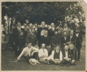
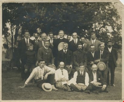
Burnaby Lake residents
https://search.heritageburnaby.ca/link/archivedescription34058
- Repository
- City of Burnaby Archives
- Date
- 1912
- Collection/Fonds
- Burnaby Historical Society fonds
- Description Level
- Item
- Physical Description
- 1 photograph : b&w ; 9.5 x 11.6 cm
- Scope and Content
- Photograph of a group of male Burnaby Lake residents posed outside near Deer Lake Drive. Identified, standing: B.R. Hill (3rd from left), Rev. D. Dunlop (6th from left), Harry Ramsay (8th from left), Louis "Edgar" Sprott (9th from left), and George Every-Clayton (10th from left). Sitting on bench…
- Repository
- City of Burnaby Archives
- Date
- 1912
- Collection/Fonds
- Burnaby Historical Society fonds
- Subseries
- Photographs subseries
- Physical Description
- 1 photograph : b&w ; 9.5 x 11.6 cm
- Description Level
- Item
- Record No.
- 003-001
- Access Restriction
- No restrictions
- Reproduction Restriction
- No known restrictions
- Accession Number
- BHS2007-04
- Scope and Content
- Photograph of a group of male Burnaby Lake residents posed outside near Deer Lake Drive. Identified, standing: B.R. Hill (3rd from left), Rev. D. Dunlop (6th from left), Harry Ramsay (8th from left), Louis "Edgar" Sprott (9th from left), and George Every-Clayton (10th from left). Sitting on bench: [first name unknown] Clayton (1st from left), Robert Pontifex (2nd from left), Mr. Clay (4th from left), and Frank Hill (6th from left). Sitting on ground: Claude Hill (1st from left) and Percy Boyer Brown (2nd from left).
- Names
- Brown, Percy Boyer
- Every-Clayton, George
- Dunlop, Rev. D.
- Hill, Bernard R.
- Hill, Frank
- Brown, Alex
- Hill, Louis Claude "Claude"
- Pontifex, Robert
- Ramsay, Harry
- Sprott, Louis "Edgar"
- Media Type
- Photograph
- Notes
- Title based on contents of photograph
- Identification key accompanying in the envelope for photo 003-001 (labeled BHS 3.1)
- Geographic Access
- Deer Lake
- Deer Lake Avenue
- Historic Neighbourhood
- Vancouver Heights (Historic Neighbourhood)
- Burnaby Lake (Historic Neighbourhood)
- Planning Study Area
- Douglas-Gilpin Area
Images