![Baldwin House, [2002] thumbnail](/media/hpo/_Data/_Archives_Images/_Unrestricted/535/535-2830-2.jpg?width=280)
Baldwin House
https://search.heritageburnaby.ca/link/archivedescription97491
- Repository
- City of Burnaby Archives
- Date
- [2002]
- Collection/Fonds
- Burnaby NewsLeader photograph collection
- Description Level
- File
- Physical Description
- 4 photographs (tiff) : col.
- Scope and Content
- File contains of photographs of Baldwin House on Deer Lake, the home designed for the Baldwins by Arthur Erickson, prior to its heritage designation by the City of Burnaby. Photographs depict Ruth Baldwin posing on the house's deck by Deer Lake; an exterior view of the home; the home's dock; and a …
- Repository
- City of Burnaby Archives
- Date
- [2002]
- Collection/Fonds
- Burnaby NewsLeader photograph collection
- Physical Description
- 4 photographs (tiff) : col.
- Description Level
- File
- Record No.
- 535-2830
- Access Restriction
- No restrictions
- Reproduction Restriction
- No restrictions
- Accession Number
- 2018-12
- Scope and Content
- File contains of photographs of Baldwin House on Deer Lake, the home designed for the Baldwins by Arthur Erickson, prior to its heritage designation by the City of Burnaby. Photographs depict Ruth Baldwin posing on the house's deck by Deer Lake; an exterior view of the home; the home's dock; and a view of the interior living room with its original drapes and Scandinavian furniture.
- Subjects
- Buildings - Heritage
- Buildings - Residential - Houses
- Geographic Features - Lakes and Ponds
- Names
- Baldwin, Ruth
- Media Type
- Photograph
- Photographer
- Bartel, Mario
- Notes
- Title based on caption
- Collected by editorial for use in an October 2002 issue of the Burnaby NewsLeader
- Caption from metadata for 535-2830-1: "Ruth Baldwin enjoys the view of Deer Lake from the lower level of the house designed for her and her husband by Arthur Erickson, an old school chum. The house is now owned by the City of Burnaby, which wants to give it a heritage designation."
- Caption from metadata for 535-2830-2: "Architect Arthur Erickson designed Baldwin House to complement its surroundings, on the southern shore of Deer Lake. But there were technical challenges, like supporting the house in the swampy soil."
- Caption from metadata for 535-2830-4: "The living room of Baldwin House is like a time capsule to the 1960's, with the original drapes and contemporary Scandanavian furniture that was in style at the time."
- Geographic Access
- Deer Lake Drive
- Deer Lake
- Street Address
- 6543 Deer Lake Drive
- Historic Neighbourhood
- Burnaby Lake (Historic Neighbourhood)
- Planning Study Area
- Morley-Buckingham Area
Images
![Baldwin House, [2002] thumbnail](/media/hpo/_Data/_Archives_Images/_Unrestricted/535/535-2830-2.jpg)
![BCIT solar home construction, [2000] thumbnail](/media/hpo/_Data/_Archives_Images/_Unrestricted/535/535-2104.jpg?width=280)
BCIT solar home construction
https://search.heritageburnaby.ca/link/archivedescription96480
- Repository
- City of Burnaby Archives
- Date
- [2000]
- Collection/Fonds
- Burnaby NewsLeader photograph collection
- Description Level
- Item
- Physical Description
- 1 photograph (tiff) : col.
- Scope and Content
- Photograph of construction worker Jas Chohan checking the level of a foundation wall for a new prefabricated solar home at BCIT. Other pieces of the home on transport trucks are visible in the background.
- Repository
- City of Burnaby Archives
- Date
- [2000]
- Collection/Fonds
- Burnaby NewsLeader photograph collection
- Physical Description
- 1 photograph (tiff) : col.
- Description Level
- Item
- Record No.
- 535-2104
- Access Restriction
- No restrictions
- Reproduction Restriction
- No restrictions
- Accession Number
- 2018-12
- Scope and Content
- Photograph of construction worker Jas Chohan checking the level of a foundation wall for a new prefabricated solar home at BCIT. Other pieces of the home on transport trucks are visible in the background.
- Media Type
- Photograph
- Photographer
- Bartel, Mario
- Notes
- Title based on caption
- Collected by editorial for use in a March 2000 issue of the Burnaby NewsLeader
- Caption from metadata: "Jas Chohan checks the level on a foundation wall being built at BCIT for a new prefabricated solar home, which is being delivered in pieces in the background."
- Geographic Access
- Willingdon Avenue
- Street Address
- 3700 Willingdon Avenue
- Historic Neighbourhood
- Burnaby Lake (Historic Neighbourhood)
- Planning Study Area
- Douglas-Gilpin Area
Images
![BCIT solar home construction, [2000] thumbnail](/media/hpo/_Data/_Archives_Images/_Unrestricted/535/535-2104.jpg)
![Brookfield, [1896] thumbnail](/media/hpo/_Data/_Archives_Images/_Unrestricted/477/477-945.jpg?width=280)
Brookfield
https://search.heritageburnaby.ca/link/archivedescription66232
- Repository
- City of Burnaby Archives
- Date
- [1896]
- Collection/Fonds
- Peers Family and Hill Family fonds
- Description Level
- Item
- Physical Description
- 1 photograph : b&w ; 9.5 x 13 cm
- Scope and Content
- Photograph of the first home of Claude Hill in the Burnaby Lake district. It was known as Brookfield. This was the birthplace of Kitty Hill. The property is the current site of the Burnaby Village Museum.
- Repository
- City of Burnaby Archives
- Date
- [1896]
- Collection/Fonds
- Peers Family and Hill Family fonds
- Physical Description
- 1 photograph : b&w ; 9.5 x 13 cm
- Description Level
- Item
- Record No.
- 477-945
- Access Restriction
- No restrictions
- Reproduction Restriction
- No known restrictions
- Accession Number
- 2007-12
- Scope and Content
- Photograph of the first home of Claude Hill in the Burnaby Lake district. It was known as Brookfield. This was the birthplace of Kitty Hill. The property is the current site of the Burnaby Village Museum.
- Subjects
- Buildings - Residential - Houses
- Media Type
- Photograph
- Notes
- Title based on contents of photograph
- Note on verso reads "1902"
- Geographic Access
- Deer Lake Avenue
- Street Address
- 6501 Deer Lake Avenue
- Historic Neighbourhood
- Burnaby Lake (Historic Neighbourhood)
- Planning Study Area
- Morley-Buckingham Area
Images
![Brookfield, [1896] thumbnail](/media/hpo/_Data/_Archives_Images/_Unrestricted/477/477-945.jpg)

Brookfield
https://search.heritageburnaby.ca/link/archivedescription39520
- Repository
- City of Burnaby Archives
- Date
- 1896
- Collection/Fonds
- Peers Family and Hill Family fonds
- Description Level
- Item
- Physical Description
- 1 photograph : b&w ; 11.5 x 16.1 cm on page 21.5 x 28 cm (pasted in album)
- Scope and Content
- Photograph of the home of Claude Hill in the Burnaby Lake district. It was known as Brookfield. The property is the current site of the Burnaby Village Museum.
- Repository
- City of Burnaby Archives
- Date
- 1896
- Collection/Fonds
- Peers Family and Hill Family fonds
- Physical Description
- 1 photograph : b&w ; 11.5 x 16.1 cm on page 21.5 x 28 cm (pasted in album)
- Description Level
- Item
- Record No.
- 477-839
- Access Restriction
- No restrictions
- Reproduction Restriction
- No known restrictions
- Accession Number
- 2007-12
- Scope and Content
- Photograph of the home of Claude Hill in the Burnaby Lake district. It was known as Brookfield. The property is the current site of the Burnaby Village Museum.
- Subjects
- Buildings - Residential - Houses
- Media Type
- Photograph
- Notes
- Title based on contents of photograph
- Geographic Access
- Deer Lake Avenue
- Street Address
- 6501 Deer Lake Avenue
- Historic Neighbourhood
- Burnaby Lake (Historic Neighbourhood)
- Planning Study Area
- Morley-Buckingham Area
Images

![Brookfield, [1896] thumbnail](/media/hpo/_Data/_BVM_Images/1973/1973_0040_0001_001.jpg?width=280)
Brookfield
https://search.heritageburnaby.ca/link/museumdescription988
- Repository
- Burnaby Village Museum
- Date
- [1896]
- Collection/Fonds
- Burnaby Village Museum Photograph collection
- Description Level
- Item
- Physical Description
- 1 photograph : b&w ; 12.1 x 17.7 cm
- Scope and Content
- Photograph of the house built about 1894 that Louis Claud Hill called "Brookfield." Mr. Hill was married that year to Annie Sara Kendrick, and they took up residence in the house until 1906 when they sold the property and built a new home in the vicinity of Buckingham and Sperling. Brookfield was…
- Repository
- Burnaby Village Museum
- Collection/Fonds
- Burnaby Village Museum Photograph collection
- Description Level
- Item
- Physical Description
- 1 photograph : b&w ; 12.1 x 17.7 cm
- Scope and Content
- Photograph of the house built about 1894 that Louis Claud Hill called "Brookfield." Mr. Hill was married that year to Annie Sara Kendrick, and they took up residence in the house until 1906 when they sold the property and built a new home in the vicinity of Buckingham and Sperling. Brookfield was still on the property when the Burnaby Village Museum was planned in 1971 as Heritage Village, but it was torn down to make room for other buildings on the site. An acquisition record notes that this house stood immediately behind the Elworth House, and Colonel Peers' (the donor) mother was born in this house in 1898. Annotations on the back of the photo read, "1896 'Brookfield'" and "The residence of Mr.+Mrs. LC Hill, the first residence on the site of Heritage Court. It stood immediately behind what is now called the Manor House. Built about 1894."
- Subjects
- Buildings - Residential - Houses
- Geographic Access
- Deer Lake Avenue
- Street Address
- 6501 Deer Lake Avenue
- Accession Code
- HV973.40.1
- Access Restriction
- No restrictions
- Reproduction Restriction
- No known restrictions
- Date
- [1896]
- Media Type
- Photograph
- Historic Neighbourhood
- Burnaby Lake (Historic Neighbourhood)
- Planning Study Area
- Morley-Buckingham Area
- Scan Resolution
- 600
- Scan Date
- 2023-05-09
- Scale
- 100
- Notes
- Title based on contents of photograph
Images
![Brookfield, [1896] thumbnail](/media/hpo/_Data/_BVM_Images/1973/1973_0040_0001_001.jpg)

Douglas Road
https://search.heritageburnaby.ca/link/archivedescription35897
- Repository
- City of Burnaby Archives
- Date
- 1895 (date of original), copied 1986
- Collection/Fonds
- Burnaby Historical Society fonds
- Description Level
- Item
- Physical Description
- 1 photograph : b&w ; 12.7 x 17.8 cm print
- Scope and Content
- Photograph of Douglas Road at Haszard Hill.
- Repository
- City of Burnaby Archives
- Date
- 1895 (date of original), copied 1986
- Collection/Fonds
- Burnaby Historical Society fonds
- Subseries
- Pioneer Tales subseries
- Physical Description
- 1 photograph : b&w ; 12.7 x 17.8 cm print
- Description Level
- Item
- Record No.
- 204-756
- Access Restriction
- No restrictions
- Reproduction Restriction
- No known restrictions
- Accession Number
- BHS1988-03
- Scope and Content
- Photograph of Douglas Road at Haszard Hill.
- Subjects
- Geographic Features - Roads
- Media Type
- Photograph
- Notes
- Title based on contents of photograph
- Type note under photograph reads, "Douglas Road, 1895. Deviation from old road, seen on right at, then, Haszard Hill, now Rayside Ave, looking eastward up the hill."
- Geographic Access
- Douglas Road
- Historic Neighbourhood
- Burnaby Lake (Historic Neighbourhood)
- Planning Study Area
- Morley-Buckingham Area
Images

![Douglas Road, [1897] (date of original), copied 1978 thumbnail](/media/hpo/_Data/_BVM_Images/1978/1978_0001_0001_001.jpg?width=280)
Douglas Road
https://search.heritageburnaby.ca/link/museumdescription447
- Repository
- Burnaby Village Museum
- Date
- [1897] (date of original), copied 1978
- Collection/Fonds
- Burnaby Village Museum Photograph collection
- Description Level
- Item
- Physical Description
- 1 photograph : b&w ; 20.2 x 25.2 cm print
- Scope and Content
- Photograph of Douglas Road (later renamed in part Canada Way), near Stanley Street. To the right is the Sprott family property, where a few wooden buildings are visible in the cleared area. Charles Sprott, head of the Sprott family, was an important Burnaby politician who was continuously elected t…
- Repository
- Burnaby Village Museum
- Collection/Fonds
- Burnaby Village Museum Photograph collection
- Description Level
- Item
- Physical Description
- 1 photograph : b&w ; 20.2 x 25.2 cm print
- Scope and Content
- Photograph of Douglas Road (later renamed in part Canada Way), near Stanley Street. To the right is the Sprott family property, where a few wooden buildings are visible in the cleared area. Charles Sprott, head of the Sprott family, was an important Burnaby politician who was continuously elected to serve in the municiality as councillor from 1895 to 1903 and as Reeve from 1904 to 1905.
- Subjects
- Geographic Features - Roads
- Land Clearing
- Geographic Access
- Douglas Road
- Canada Way
- Stanley Street
- Accession Code
- HV978.1.1
- Access Restriction
- No restrictions
- Reproduction Restriction
- No known restrictions
- Date
- [1897] (date of original), copied 1978
- Media Type
- Photograph
- Historic Neighbourhood
- Burnaby Lake (Historic Neighbourhood)
- Planning Study Area
- Lakeview-Mayfield Area
- Scan Resolution
- 600
- Scan Date
- 2023-07-25
- Notes
- Title based on contents of photograph
Images
![Douglas Road, [1897] (date of original), copied 1978 thumbnail](/media/hpo/_Data/_BVM_Images/1978/1978_0001_0001_001.jpg)

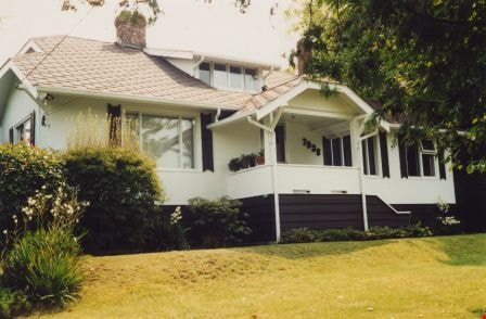
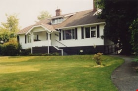
House on Rosewood Street
https://search.heritageburnaby.ca/link/archivedescription38536
- Repository
- City of Burnaby Archives
- Date
- 2001
- Collection/Fonds
- Burnaby Historical Society fonds
- Description Level
- Item
- Physical Description
- 1 photograph : col. ; 10 x 15 cm + 1 col. negative
- Scope and Content
- Photograph of the house located at 7938 Rosewood Street built in 1922 and demolished in 2001.
- Repository
- City of Burnaby Archives
- Date
- 2001
- Collection/Fonds
- Burnaby Historical Society fonds
- Subseries
- Photographs subseries
- Physical Description
- 1 photograph : col. ; 10 x 15 cm + 1 col. negative
- Description Level
- Item
- Record No.
- 456-001
- Access Restriction
- No restrictions
- Reproduction Restriction
- Reproduce for fair dealing purposes only
- Accession Number
- BHS2007-04
- Scope and Content
- Photograph of the house located at 7938 Rosewood Street built in 1922 and demolished in 2001.
- Subjects
- Buildings - Residential - Houses
- Media Type
- Photograph
- Notes
- Title based on contents of photograph
- Geographic Access
- Rosewood Street
- Street Address
- 7938 Rosewood Street
- Historic Neighbourhood
- Burnaby Lake (Historic Neighbourhood)
- Planning Study Area
- Lakeview-Mayfield Area
Images
House on Rosewood Street
https://search.heritageburnaby.ca/link/archivedescription38537
- Repository
- City of Burnaby Archives
- Date
- 2001
- Collection/Fonds
- Burnaby Historical Society fonds
- Description Level
- Item
- Physical Description
- 1 photograph : col. ; 10 x 15 cm + 1 col. negative
- Scope and Content
- Photograph of the house located at 7938 Rosewood Street built in 1922 and demolished in 2001.
- Repository
- City of Burnaby Archives
- Date
- 2001
- Collection/Fonds
- Burnaby Historical Society fonds
- Subseries
- Photographs subseries
- Physical Description
- 1 photograph : col. ; 10 x 15 cm + 1 col. negative
- Description Level
- Item
- Record No.
- 456-002
- Access Restriction
- No restrictions
- Reproduction Restriction
- Reproduce for fair dealing purposes only
- Accession Number
- BHS2007-04
- Scope and Content
- Photograph of the house located at 7938 Rosewood Street built in 1922 and demolished in 2001.
- Subjects
- Buildings - Residential - Houses
- Media Type
- Photograph
- Notes
- Title based on contents of photograph
- Geographic Access
- Rosewood Street
- Street Address
- 7938 Rosewood Street
- Historic Neighbourhood
- Burnaby Lake (Historic Neighbourhood)
- Planning Study Area
- Lakeview-Mayfield Area
Images

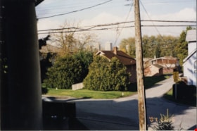
Looking north from 5496 Dominion Street
https://search.heritageburnaby.ca/link/archivedescription91854
- Repository
- City of Burnaby Archives
- Date
- November 2001
- Collection/Fonds
- Small family fonds
- Description Level
- Item
- Physical Description
- 1 photograph : col. ; 10 cm x 15 cm
- Scope and Content
- Photograph of the McLean family's house located at 5493 Dominion Street. The property was later owned by the McFaydens. The photograph was taken from the porch of the house at 5496 Dominion Street, looking north, and the house is largely obscured by trees.
- Repository
- City of Burnaby Archives
- Date
- November 2001
- Collection/Fonds
- Small family fonds
- Physical Description
- 1 photograph : col. ; 10 cm x 15 cm
- Description Level
- Item
- Record No.
- 620-035
- Access Restriction
- No restrictions
- Reproduction Restriction
- No reproduction permitted
- Accession Number
- 2017-01
- Scope and Content
- Photograph of the McLean family's house located at 5493 Dominion Street. The property was later owned by the McFaydens. The photograph was taken from the porch of the house at 5496 Dominion Street, looking north, and the house is largely obscured by trees.
- Subjects
- Buildings - Residential - Houses
- Media Type
- Photograph
- Notes
- Transcribed title
- Title transcribed from donor's notes
- Note in blue ink on verso of photograph reads: "P.35"
- Note in black ink on verso of photograph reads: "McLean's old house Nov. 2001"
- Note in blue ink on verso of photograph reads: "(later, McFayden's)"
- 5493 Dominion Street was previously numbered 3107 Dominion Street and it was later subdivided into two lots: 5491 and 5495 Dominion Street.
- Street Address
- 3107 Dominion Street
- 5493 Dominion Street
- Historic Neighbourhood
- Burnaby Lake (Historic Neighbourhood)
- Planning Study Area
- Ardingley-Sprott Area
Images
Looking north from 5496 Dominion Street
https://search.heritageburnaby.ca/link/archivedescription91855
- Repository
- City of Burnaby Archives
- Date
- 2002
- Collection/Fonds
- Small family fonds
- Description Level
- Item
- Physical Description
- 1 photograph : col. ; 10 cm x 15 cm
- Scope and Content
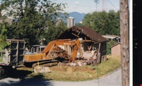
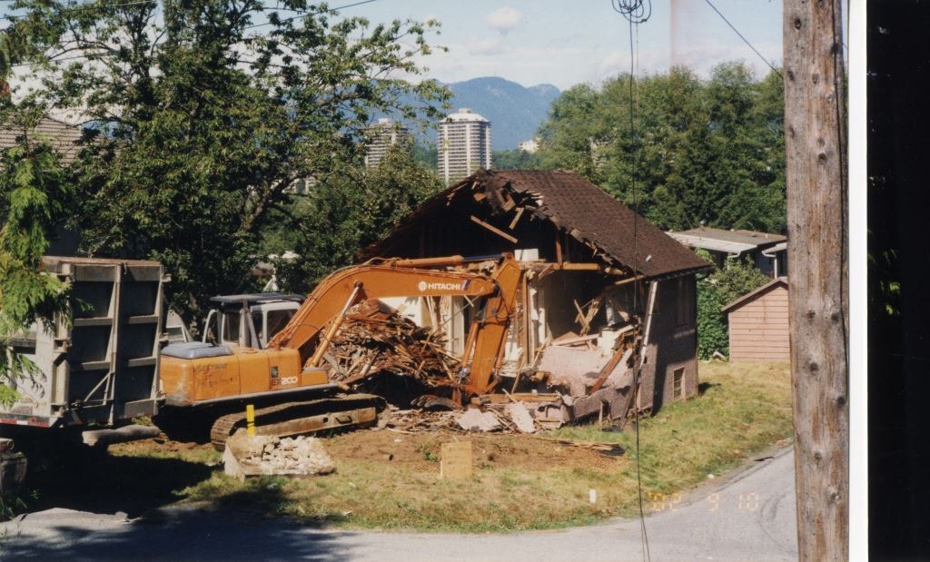
- Photograph of the house at 5493 Dominion Street being demolished. The house was previously owned by the McLean family. The photograph was taken from 5496 Dominion Street, looking north.
- Repository
- City of Burnaby Archives
- Date
- 2002
- Collection/Fonds
- Small family fonds
- Physical Description
- 1 photograph : col. ; 10 cm x 15 cm
- Description Level
- Item
- Record No.
- 620-036
- Access Restriction
- No restrictions
- Reproduction Restriction
- No reproduction permitted
- Accession Number
- 2017-01
- Scope and Content
- Photograph of the house at 5493 Dominion Street being demolished. The house was previously owned by the McLean family. The photograph was taken from 5496 Dominion Street, looking north.
- Media Type
- Photograph
- Notes
- Transcribed title
- Note in blue ink on verso of photograph reads: "P.35"
- Note in blue ink on verso of photograph reads: "2002"
- Note in blue ink on verso of photograph reads: "Farewell [illegible] old house on Dominion Street"
- 5493 Dominion Street was previously numbered 3107 Dominion Street and it was later subdivided into two lots: 5491 and 5495 Dominion Street.
- Street Address
- 3107 Dominion Street
- 5493 Dominion Street
- Historic Neighbourhood
- Burnaby Lake (Historic Neighbourhood)
- Planning Study Area
- Ardingley-Sprott Area
Images

Looking north from 5496 Dominion Street
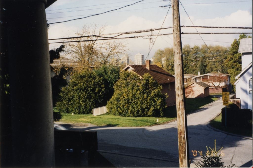
https://search.heritageburnaby.ca/link/archivedescription91856
- Repository
- City of Burnaby Archives
- Date
- December 22, 2008
- Collection/Fonds
- Small family fonds
- Description Level
- Item
- Physical Description
- 1 photograph : col. ; 10 cm x 15 cm
- Scope and Content
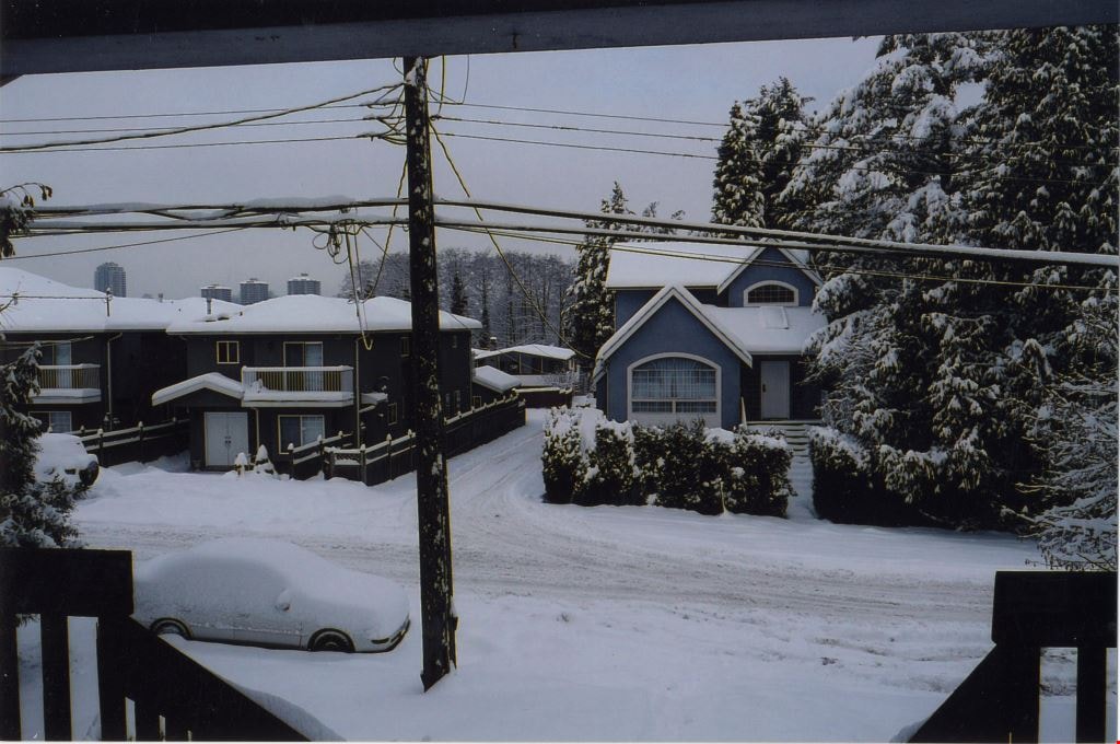
- Photograph of two duplexes located at 5491 and 5495 Dominion Street (left) and house at 5505 Dominion Street (right) after a snowfall. The duplexes replaced a single-family home located at 5493 (previously 3107) Dominion Street following the lot's subdivision. The photograph was taken from the po…
- Repository
- City of Burnaby Archives
- Date
- December 22, 2008
- Collection/Fonds
- Small family fonds
- Physical Description
- 1 photograph : col. ; 10 cm x 15 cm
- Description Level
- Item
- Record No.
- 620-037
- Access Restriction
- No restrictions
- Reproduction Restriction
- No reproduction permitted
- Accession Number
- 2017-01
- Scope and Content
- Photograph of two duplexes located at 5491 and 5495 Dominion Street (left) and house at 5505 Dominion Street (right) after a snowfall. The duplexes replaced a single-family home located at 5493 (previously 3107) Dominion Street following the lot's subdivision. The photograph was taken from the porch at 5496 Dominion street, looking north.
- Media Type
- Photograph
- Notes
- Title based on contents of photograph
- Note in blue ink on verso of photograph reads: "P.36"
- Note in blue ink on verso of photograph reads: "Dec. 22, 2008 / 2 New Duplex's replace 5493 Dominion Street"
- 5493 Dominion Street was previously numbered 3107 Dominion Street and it was later subdivided into two lots: 5491 and 5495 Dominion Street.
- Photograph 620-034 depicts the same house at 5505 Dominion Street and the previous house located at 5495 Dominion Street.
- Historic Neighbourhood
- Burnaby Lake (Historic Neighbourhood)
- Planning Study Area
- Ardingley-Sprott Area
Images
Rayside Drive and Canada Way
https://search.heritageburnaby.ca/link/archivedescription38433
- Repository
- City of Burnaby Archives
- Date
- 2002
- Collection/Fonds
- Burnaby Historical Society fonds
- Description Level
- Item
- Physical Description
- 1 photograph : colour ; 10 x 15 cm
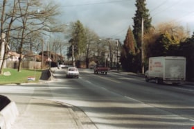
- Scope and Content
- Photograph shows truck driving along Canada Way just past the Rayside Drive intersection.
- Repository
- City of Burnaby Archives
- Date
- 2002
- Collection/Fonds
- Burnaby Historical Society fonds
- Subseries
- Photographs subseries
- Physical Description
- 1 photograph : colour ; 10 x 15 cm
- Description Level
- Item
- Record No.
- 442-001
- Access Restriction
- No restrictions
- Reproduction Restriction
- Reproduce for fair dealing purposes only
- Accession Number
- BHS2007-04
- Scope and Content
- Photograph shows truck driving along Canada Way just past the Rayside Drive intersection.
- Subjects
- Geographic Features - Roads
- Media Type
- Photograph
- Notes
- Title based on contents of photograph.
- Geographic Access
- Canada Way
- Rayside Street
- Historic Neighbourhood
- Burnaby Lake (Historic Neighbourhood)
- Planning Study Area
- Morley-Buckingham Area
Images


Rayside Drive and Canada Way
https://search.heritageburnaby.ca/link/archivedescription39753
- Repository
- City of Burnaby Archives
- Date
- 2002
- Collection/Fonds
- Burnaby Historical Society fonds
- Description Level
- Item
- Physical Description
- 1 photograph : col.; 10 x 15 cm
- Scope and Content
- Photograph of vehicle traffic along Canada Way just past the Rayside Drive intersection.
- Repository
- City of Burnaby Archives
- Date
- 2002
- Collection/Fonds
- Burnaby Historical Society fonds
- Subseries
- Photographs subseries
- Physical Description
- 1 photograph : col.; 10 x 15 cm
- Description Level
- Item
- Record No.
- 442-002
- Access Restriction
- No restrictions
- Reproduction Restriction
- Reproduce for fair dealing purposes only
- Accession Number
- BHS2007-04
- Scope and Content
- Photograph of vehicle traffic along Canada Way just past the Rayside Drive intersection.
- Media Type
- Photograph
- Notes
- Title based on contents of photograph.
- Geographic Access
- Canada Way
- Rayside Street
- Historic Neighbourhood
- Burnaby Lake (Historic Neighbourhood)
- Planning Study Area
- Morley-Buckingham Area
Images
