Narrow Results By
Person / Organization
- Army, Navy and Air Force Veterans in Canada, Pompier Unit #314 1
- Baker, Ronald J. "Ron" 2
- Bossort, Kathy 2
- Bridge Studios 2
- Burnaby Fire Department 1
- Burnaby Historical Society 2
- Burnaby Village Museum 2
- Damer, Eric 1
- Elliot, Ken 1
- Gardner, Bob 1
- Hagen, Judith "Judy" Robins 1
- Hill, Louis Claude "Claude" 1
Financial Assistance for Play Structures on School Sites
https://search.heritageburnaby.ca/link/councilreport11955
- Repository
- City of Burnaby Archives
- Report ID
- 8338
- Meeting Date
- 11-Jun-1990
- Format
- Council - Manager's Report
- Manager's Report No.
- 40
- Item No.
- 12
- Collection/Fonds
- City Council and Office of the City Clerk fonds
- Repository
- City of Burnaby Archives
- Report ID
- 8338
- Meeting Date
- 11-Jun-1990
- Format
- Council - Manager's Report
- Manager's Report No.
- 40
- Item No.
- 12
- Collection/Fonds
- City Council and Office of the City Clerk fonds
Documents
Moving of Eight Pan-Abode Structures
https://search.heritageburnaby.ca/link/councilreport13728
- Repository
- City of Burnaby Archives
- Report ID
- 9355
- Meeting Date
- 11-Jul-1988
- Format
- Council - Manager's Report
- Manager's Report No.
- 47
- Item No.
- 12
- Collection/Fonds
- City Council and Office of the City Clerk fonds
- Repository
- City of Burnaby Archives
- Report ID
- 9355
- Meeting Date
- 11-Jul-1988
- Format
- Council - Manager's Report
- Manager's Report No.
- 47
- Item No.
- 12
- Collection/Fonds
- City Council and Office of the City Clerk fonds
Documents
Permanent Roof Structures Covering Restaurant Outdoor Patios - Burnaby Smoking Regulation Bylaw 1987
https://search.heritageburnaby.ca/link/councilreport7132
- Repository
- City of Burnaby Archives
- Report ID
- 6470
- Meeting Date
- 10-Jun-1996
- Format
- Council - Manager's Report
- Manager's Report No.
- 16
- Item No.
- 15
- Collection/Fonds
- City Council and Office of the City Clerk fonds
- Repository
- City of Burnaby Archives
- Report ID
- 6470
- Meeting Date
- 10-Jun-1996
- Format
- Council - Manager's Report
- Manager's Report No.
- 16
- Item No.
- 15
- Collection/Fonds
- City Council and Office of the City Clerk fonds
Documents
Request for Demolition Permit; Metro-Centre Hotel and Associated Structures; Rezoning Reference #21/96 and #22/96; Subdivision Reference #37/96
https://search.heritageburnaby.ca/link/councilreport6572
- Repository
- City of Burnaby Archives
- Report ID
- 60563
- Meeting Date
- 3-Mar-1997
- Format
- Council - Manager's Report
- Manager's Report No.
- 7
- Item No.
- 12
- Collection/Fonds
- City Council and Office of the City Clerk fonds
- Repository
- City of Burnaby Archives
- Report ID
- 60563
- Meeting Date
- 3-Mar-1997
- Format
- Council - Manager's Report
- Manager's Report No.
- 7
- Item No.
- 12
- Collection/Fonds
- City Council and Office of the City Clerk fonds
Documents
Request for Financial Assistance for Play Structures on School Sites
https://search.heritageburnaby.ca/link/councilreport9535
- Repository
- City of Burnaby Archives
- Report ID
- 6384
- Meeting Date
- 21-Jun-1993
- Format
- Council - Manager's Report
- Manager's Report No.
- 41
- Item No.
- 1
- Collection/Fonds
- City Council and Office of the City Clerk fonds
- Repository
- City of Burnaby Archives
- Report ID
- 6384
- Meeting Date
- 21-Jun-1993
- Format
- Council - Manager's Report
- Manager's Report No.
- 41
- Item No.
- 1
- Collection/Fonds
- City Council and Office of the City Clerk fonds
Documents

Charles R. Shaw House
https://search.heritageburnaby.ca/link/landmark525
- Repository
- Burnaby Heritage Planning
- Description
- The Charles R. Shaw House is a one and one-half storey plus basement wood-frame late Victorian era residence, located on the grounds of the Normanna Rest Home development in East Burnaby, near its original location on this site. Originally a modest vernacular Victorian structure, it has been enlarg…
- Associated Dates
- 1891
- Formal Recognition
- Heritage Designation, Community Heritage Register
- Other Names
- Charles R. & Mary Shaw House
- Street View URL
- Google Maps Street View
- Repository
- Burnaby Heritage Planning
- Other Names
- Charles R. & Mary Shaw House
- Geographic Access
- 12th Avenue
- 4th Street
- 13th Avenue
- Associated Dates
- 1891
- Formal Recognition
- Heritage Designation, Community Heritage Register
- Enactment Type
- Bylaw No. 10739
- Enactment Date
- 06/04/1998
- Description
- The Charles R. Shaw House is a one and one-half storey plus basement wood-frame late Victorian era residence, located on the grounds of the Normanna Rest Home development in East Burnaby, near its original location on this site. Originally a modest vernacular Victorian structure, it has been enlarged and embellished through later additions.
- Heritage Value
- The Shaw House is one of the oldest surviving houses in Burnaby, and is valued as a representation of a typical vernacular pioneer house in Burnaby, and a rare survivor from the late Victorian era. The original portion of the house displays a simplicity of form and detail consistent with early local construction, while the later additions display a more sophisticated approach. Originally built in 1891, this house is valued for its association with first owner, Charles R. Shaw (1834-1916) and Mary D. Shaw (1848-1897), one of Burnaby’s earliest settlers. Born in England, Shaw immigrated to Toronto in 1869, and relocated to New Westminster in 1889, where he worked as an employee of the Mechanic's Mill Company, an early woodworking plant. After moving to Burnaby, he was unanimously elected by acclamation as first reeve (mayor) of the new municipality in 1892. In 1894, Shaw sold his house and farm and moved his family to Kamloops due to his wife Mary's failing health. After Mary died in 1897, the Shaw family returned to Toronto. The Shaw House is additionally valued for its association with a later owner, James Brookes (1884-1953), founder of James Brookes Woodworking Ltd., a mill that was a major employer in East Burnaby. Brookes bought and renovated the house in 1917. In 1927, he built a much larger house on the property (now demolished), and the original house was moved to the corner of the property to serve as a gardener's cottage for Brookes' estate. The additions made to the house at this time employed sash and milled products produced by the Brookes plant. Although altered, this Victorian era residence remains largely intact, with Brookes’s later additions.
- Defining Elements
- Key elements that define the heritage character of the Shaw House include its: - modest vernacular residential form, scale and massing, as exemplified by its one and one-half storey plus basement height, front gabled roof, shed roofed verandah and asymmetrical plan - asymmetrical front entrance - cladding: horizontal wooden drop siding on the original portion of the house; cedar shingles on additions; decorative octagonal cedar shingles in the front gable; original decorated bargeboards at front, with cut-out details - later renovations to the front verandah and side addition which resulted in a partially glazed porch entrance and addition with large window assemblies - square verandah columns - irregular fenestration: double-hung wooden-sash windows in a variety of configurations such as 6-over-1 and 4-over-1 windows in the original portion of the house, 12-over-1 windows, and one 24-over-1 window in the front addition - small window at front entry - fifteen-pane French front entry door - internal red brick chimney with corbelled cap
- Historic Neighbourhood
- East Burnaby (Historic Neighbourhood)
- Planning Study Area
- Edmonds Area
- Function
- Primary Historic--Single Dwelling
- Primary Current--Single Dwelling
- Community
- Burnaby
- Cadastral Identifier
- 003-253-848
- Boundaries
- The Shaw House is comprised of a single residential lot located at 7725 Fourth Street (legal address), Burnaby
- Area
- 9199.27
- Contributing Resource
- Building
- Ownership
- Private
- Names
- Shaw, Charles R
- Street Address
- 7725 4th Street
- Street View URL
- Google Maps Street View
Images


Jesse Love House
https://search.heritageburnaby.ca/link/landmark540
- Repository
- Burnaby Heritage Planning
- Description
- The Jesse Love House is a vernacular example of a late Victorian-era wood-frame farmhouse with later Arts and Crafts alterations and additions, that has been relocated to the Burnaby Village Museum. This two-storey house has an L-shaped plan, with a compound gabled roof, overhanging eaves and a lar…
- Associated Dates
- 1893
- Formal Recognition
- Heritage Designation, Community Heritage Register
- Other Names
- Jesse & Martha Love Farmhouse
- Street View URL
- Google Maps Street View
- Repository
- Burnaby Heritage Planning
- Other Names
- Jesse & Martha Love Farmhouse
- Geographic Access
- Deer Lake Avenue
- Associated Dates
- 1893
- Formal Recognition
- Heritage Designation, Community Heritage Register
- Enactment Type
- Bylaw No. 9807
- Enactment Date
- 23/11/1992
- Description
- The Jesse Love House is a vernacular example of a late Victorian-era wood-frame farmhouse with later Arts and Crafts alterations and additions, that has been relocated to the Burnaby Village Museum. This two-storey house has an L-shaped plan, with a compound gabled roof, overhanging eaves and a large wraparound verandah.
- Heritage Value
- The value of the Jesse Love House lies in its comprehensive representation of an early Burnaby farmhouse, and the typical additive growth of a home as the resident family prospered. Jesse Love (1849-1928) and his wife Martha Love (1858-1920) moved to Burnaby in 1893 with their family to start a fruit ranch and market garden on Cumberland Road in the East Burnaby district. Jesse Love was actively involved in community affairs, serving on the Burnaby School Board and also as a District Councillor in 1901 and from 1904-07. The original house was constructed by local builder George Salt and consisted of an entrance hall, dining room, lean-to kitchen, master bedroom and several rooms upstairs. As the family grew and prospered, additions were made to the house including a parlour, more bedrooms upstairs, and a large permanent kitchen. Jesse Love was actively involved in community affairs, and the kitchen became a local gathering spot for political discussion and civic organizations. The verandah, exterior shingle cladding, large windows, running water and electricity were eventually added as well. The heritage value for this house also lies in its interpretive value within the Burnaby Village Museum. The site is an important cultural feature for the interpretation of Burnaby’s heritage to the public. The house was moved to the Burnaby Village Museum in 1988 and both the interior and exterior were restored and interpreted to their 1925 period, including reproduction wallpaper.
- Defining Elements
- The character defining features of the Jesse Love House include its: - irregular form and massing - compound gable roof with cedar shingle cladding - Craftsman-style exterior features such as a shingled exterior and triangular eave brackets - multi-paned double-hung 2-over-2 wooden-sash windows; casement window assemblies with transoms in the Living Room - large wrap-around verandah - interior features such as pressed tin ceilings, original wallpapers and cedar panelled kitchen - reproduction Arts and Crafts parlour document wallpaper and border
- Locality
- Deer Lake Park
- Historic Neighbourhood
- Burnaby Lake (Historic Neighbourhood)
- Planning Study Area
- Morley-Buckingham Area
- Organization
- Burnaby Village Museum
- Builder
- George Salt
- Function
- Primary Current--Museum
- Primary Historic--Single Dwelling
- Community
- Burnaby
- Cadastral Identifier
- P.I.D. No. 011-030-356 Legal Description: Parcel 1, District Lot 79 and District Lot 85, Group 1, New Westminster District, Reference Plan 77594
- Boundaries
- Burnaby Village Museum is comprised of a single municipally-owned property located at 6501 Deer Lake Avenue, Burnaby.
- Area
- 38,488.63
- Contributing Resource
- Building
- Landscape Feature
- Structure
- Ownership
- Public (local)
- Documentation
- Heritage Site Files: PC77000 20. City of Burnaby Planning and Building Department, 4949 Canada Way, Burnaby, B.C., V5G 1M2
- Street Address
- 6501 Deer Lake Avenue
- Street View URL
- Google Maps Street View
Images


Joseph & Jane Wintemute House
https://search.heritageburnaby.ca/link/landmark523
- Repository
- Burnaby Heritage Planning
- Description
- The Wintemute House is a large two-storey wood-frame Victorian era country farm house with Victorian Italianate detailing. Designed in a symmetrical Foursquare form, it features a low-pitched hipped roof with deep eaves. Later additions to the rear of the house, and the extensive wraparound veranda…
- Associated Dates
- 1891
- Formal Recognition
- Heritage Designation, Community Heritage Register
- Other Names
- Burnett House
- Street View URL
- Google Maps Street View
- Repository
- Burnaby Heritage Planning
- Other Names
- Burnett House
- Geographic Access
- Berkley Street
- Associated Dates
- 1891
- Formal Recognition
- Heritage Designation, Community Heritage Register
- Enactment Type
- Bylaw No. 6889
- Enactment Date
- 07/03/1977
- Description
- The Wintemute House is a large two-storey wood-frame Victorian era country farm house with Victorian Italianate detailing. Designed in a symmetrical Foursquare form, it features a low-pitched hipped roof with deep eaves. Later additions to the rear of the house, and the extensive wraparound verandah and porte-cochere, were Edwardian era additions. It is located on its original site, in the modern subdivision of Buckingham Heights in southeast Burnaby. The Burnett House is one of the oldest surviving houses in Burnaby.
- Heritage Value
- Built circa 1891, the Joseph and Jane Wintemute House is valued as a representation of the early history of Burnaby and its agricultural origins. Built prior to the civic incorporation of Burnaby in 1892, the house was situated to face Douglas Road (now Canada Way), one of the first roads built to connect the rural farmlands of Burnaby to New Westminster. The original large property has been extensively subdivided and the house is now isolated in a modern subdivision. Designated in 1977, the Wintemute House is also significant as Burnaby's first protected municipal heritage site. The house is valued for its association with Joseph S. Wintemute (1832-1911) and Jane Wintemute (1832-1910), who came to British Columbia from Port Stanley, Ontario in 1865, traveling via the Isthmus of Panama. Joseph Wintemute, a skilled carpenter and contractor by trade, operated the Wintemute Furniture Factory in New Westminster, the first furniture plant established on the mainland of British Columbia. In 1891, he acquired this property, where he set up a cord wood sawmill to supply his factory. Wintemute was likely responsible for the design and construction of this commodious structure, as it was built in an Eastern Canadian style he would have been familiar with. After the lands were cleared of timber, the Wintemutes developed the property into a typical small-scale 'market garden,’ involved in the production of vegetables and fruits, such as strawberries, for sale at the New Westminster City Market. The Wintemute House is additionally significant for its association with the speculative land boom that occurred prior to the First World War, and ongoing suburban subdivision. Charles Gordon, a real estate agent, acquired the Wintemute farm and subdivided the acreage, which he marketed through the People’s Trust Company as 'Montrelynview' and offered this house as a draw prize to lot purchasers. With the collapse of the land boom, the house remained in Gordon’s possession until 1929 when it was purchased by his brother-in-law, Geoffrey Burnett, a local surveyor responsible for many of the original land surveys of Burnaby. David Burnett, Geoffrey's son, requested designation of the house when the family decided to subdivide the remaining 1.4 hectares of property in 1977. Furthermore, the Wintemute House is valued as an excellent example of a Victorian era country farm house, based loosely on the traditional farmhouses seen commonly in nineteenth century Ontario. Designed in a vernacular version of the Victorian Italianate style, the house displays restrained detailing, including several original multi-paned windows notable for their vertical proportions. The house retains many original exterior features, and the original interior layout, although modernized during the Edwardian era, is substantially intact, including finely crafted maple and cedar interior millwork that was produced by the Wintemute Furniture Factory. From 1904 to 1910, Charles Gordon, the second owner, made a number of alterations to the house including the addition of the wrap-around verandah, a porte-cochere and a 7.6 metre by 9 metre billiard room in the Arts and Crafts style, beamed and panelled in Douglas Fir. These later additions and alterations have value in demonstrating the evolution of the house and property and changing tastes at the turn of the nineteenth century.
- Defining Elements
- Key elements that define the heritage character of the Wintemute House include its: - picturesque original setting with views to the North Shore - residential form, scale and massing as expressed by its symmetrical cubic form and two-storey height, with later additions to the rear - Victorian Italianate architectural features such as the vertically-proportioned original windows with vestigial window hoods, low-pitched hipped roof and Classical Revival details such as the corner boards articulated as pilasters - hipped roof with deep boxed eaves - horizontal lapped narrow wooden siding - second storey balcony over front entry - wide wraparound columned verandah with porte-cochere, with square trimmed columns - irregular fenestration: original Victorian era double-hung 6-over-6 wood-sash windows with vertical proportions and segmental arched tops; Edwardian era double-hung 1-over-1 wooden-sash windows; and Edwardian era wooden-sash casement window assemblies with leaded transoms - central front entry with sidelights and transom - multi-paned French doors opening out to verandah - interior features such as its 3.7 metre ceiling height on the main and second floors; the coal grate fireplace with elaborate woodwork and glazed tile surround in the front parlour; five other fireplaces throughout the house; maple and cedar interior millwork; and the Douglas Fir panelled and beamed billiard room with hidden doors, seven-panelled doors, original light fixtures and mouldings - internal red brick chimneys with corbelled caps
- Historic Neighbourhood
- Burnaby Lake (Historic Neighbourhood)
- Planning Study Area
- Morley-Buckingham Area
- Function
- Primary Historic--Single Dwelling
- Primary Current--Single Dwelling
- Community
- Burnaby
- Cadastral Identifier
- 003-297-152
- Boundaries
- The Wintemute House is comprised of a single residential lot located at 7640 Berkley Street, Burnaby.
- Area
- 1566.73
- Contributing Resource
- Building
- Ownership
- Private
- Names
- Wintemute, Joseph
- Street Address
- 7640 Berkley Street
- Street View URL
- Google Maps Street View
Images


South Burnaby Cenotaph
https://search.heritageburnaby.ca/link/landmark860
- Repository
- Burnaby Heritage Planning
- Description
- The South Burnaby Cenotaph is located in Bonsor Park at the corner of Nelson Avenue and Imperial Street. The cenotaph commemorates those lost in the First World War, Second World War and the Korean War.
- Associated Dates
- 1988
- Other Names
- Bonsor Park Cenotaph
- Street View URL
- Google Maps Street View
- Repository
- Burnaby Heritage Planning
- Other Names
- Bonsor Park Cenotaph
- Geographic Access
- Nelson Avenue
- Associated Dates
- 1988
- Description
- The South Burnaby Cenotaph is located in Bonsor Park at the corner of Nelson Avenue and Imperial Street. The cenotaph commemorates those lost in the First World War, Second World War and the Korean War.
- Historic Neighbourhood
- Central Park (Historic Neighbourhood)
- Planning Study Area
- Marlborough Area
- Community
- Burnaby
- Cadastral Identifier
- P.I.D. No. 027-719-375
- Boundaries
- The property (Bonsor Park) is comprised of a single municipally-owned property located at 6749 Nelson Avenue.
- Area
- 3570.00
- Contributing Resource
- Landscape Feature
- Structure
- Ownership
- Public (local)
- Street Address
- 6749 Nelson Avenue
- Street View URL
- Google Maps Street View
Images

![Painting the wall, [1999] thumbnail](/media/hpo/_Data/_Archives_Images/_Unrestricted/535/535-3157.jpg?width=280)
Painting the wall
https://search.heritageburnaby.ca/link/archivedescription98077
- Repository
- City of Burnaby Archives
- Date
- [1999]
- Collection/Fonds
- Burnaby NewsLeader photograph collection
- Description Level
- Item
- Physical Description
- 1 photograph (tiff) : col.
- Scope and Content
- Photograph of an unidentified person painting the wall beneath a brick arch.
- Repository
- City of Burnaby Archives
- Date
- [1999]
- Collection/Fonds
- Burnaby NewsLeader photograph collection
- Physical Description
- 1 photograph (tiff) : col.
- Description Level
- Item
- Record No.
- 535-3157
- Access Restriction
- No restrictions
- Reproduction Restriction
- No restrictions
- Accession Number
- 2018-12
- Scope and Content
- Photograph of an unidentified person painting the wall beneath a brick arch.
- Subjects
- Structures
- Structures - Arches
- Media Type
- Photograph
- Notes
- Title based on original file name
- Collected by editorial for use in an April 1999 issue of the Burnaby NewsLeader
Images
![Painting the wall, [1999] thumbnail](/media/hpo/_Data/_Archives_Images/_Unrestricted/535/535-3157.jpg)

Barnet Marine Park
https://search.heritageburnaby.ca/link/archivedescription91581
- Repository
- City of Burnaby Archives
- Date
- August 9, 1996
- Collection/Fonds
- Doreen Lawson fonds
- Description Level
- File
- Physical Description
- 18 photographs : col. slides ; 35 mm
- Scope and Content
- File consists of photographs of Barnet Marine Park, including Barnet Beach pilings, overpass and people preparing kayaks on the shore.
- Repository
- City of Burnaby Archives
- Date
- August 9, 1996
- Collection/Fonds
- Doreen Lawson fonds
- Physical Description
- 18 photographs : col. slides ; 35 mm
- Description Level
- File
- Record No.
- 605-014
- Access Restriction
- No restrictions
- Reproduction Restriction
- No restrictions
- Accession Number
- 2003-30
- Scope and Content
- File consists of photographs of Barnet Marine Park, including Barnet Beach pilings, overpass and people preparing kayaks on the shore.
- Names
- Lawson, Doreen A.
- Media Type
- Photograph
- Photographer
- Lawson, Doreen A.
- Notes
- Title based on contents of photographs
- Note in black in on recto of slide frames of photographs 605-014-1 : 605-014-7, 605-014-9 : 605-014-11, and 605-014-13 reads: "Barnet Beach Pilings"
- Note in black ink on recto of slide frames of photographs 605-014-8 and 605-014-12 reads: "Barnet Beach Kayaks"
- Note in black ink on recto of slide frames of photographs 605-014-14 : 605-014-18 reads: "Barnet Beach Overpass"
- Geographic Access
- Barnet Marine Park
- Historic Neighbourhood
- Barnet (Historic Neighbourhood)
- Planning Study Area
- Burnaby Mountain Area
Images

![Bridge over South Creek on Burnaby Mountain, [1995] thumbnail](/media/Hpo/_Data/_Archives_Images/_Unrestricted/629/629-009.jpg?width=280)
Bridge over South Creek on Burnaby Mountain
https://search.heritageburnaby.ca/link/archivedescription97808
- Repository
- City of Burnaby Archives
- Date
- [1995]
- Collection/Fonds
- Burnaby Mountain Preservation Society fonds
- Description Level
- Item
- Physical Description
- 1 photograph : col. slide ; 35 mm
- Scope and Content
- Photograph of a creek bridge.
- Repository
- City of Burnaby Archives
- Date
- [1995]
- Collection/Fonds
- Burnaby Mountain Preservation Society fonds
- Physical Description
- 1 photograph : col. slide ; 35 mm
- Description Level
- Item
- Record No.
- 629-009
- Access Restriction
- No restrictions
- Reproduction Restriction
- Reproduce for fair dealing purposes only
- Accession Number
- 2006-13
- Scope and Content
- Photograph of a creek bridge.
- Media Type
- Photograph
- Notes
- Handwritten note on slide reads: "Bridge Over S. Creek."
- Geographic Access
- Burnaby Mountain Conservation Area
- Planning Study Area
- Burnaby Mountain Area
Images
![Bridge over South Creek on Burnaby Mountain, [1995] thumbnail](/media/Hpo/_Data/_Archives_Images/_Unrestricted/629/629-009.jpg)

Central Park Entrance
https://search.heritageburnaby.ca/link/archivedescription34860
- Repository
- City of Burnaby Archives
- Date
- March 23, 1985
- Collection/Fonds
- Burnaby Historical Society fonds
- Description Level
- Item
- Physical Description
- 1 photograph : col. ; 8.8 x 11.3 cm
- Scope and Content
- Photograph of the Central Park entrance on Kingsway. A car can be seen exiting the park, and the tracks of the Skytrain Expo line are in the background.
- Repository
- City of Burnaby Archives
- Date
- March 23, 1985
- Collection/Fonds
- Burnaby Historical Society fonds
- Subseries
- Evelyn Salisbury subseries
- Physical Description
- 1 photograph : col. ; 8.8 x 11.3 cm
- Description Level
- Item
- Record No.
- 145-008
- Access Restriction
- No restrictions
- Reproduction Restriction
- Reproduce for fair dealing purposes only
- Accession Number
- BHS1985-15
- Scope and Content
- Photograph of the Central Park entrance on Kingsway. A car can be seen exiting the park, and the tracks of the Skytrain Expo line are in the background.
- Subjects
- Structures - Arches
- Media Type
- Photograph
- Notes
- Title based on contents of photograph
- Geographic Access
- Central Park
- Imperial Street
- Street Address
- 3883 Imperial Street
- Historic Neighbourhood
- Central Park (Historic Neighbourhood)
- Planning Study Area
- Maywood Area
Images


Central Park Entrance
https://search.heritageburnaby.ca/link/archivedescription34861
- Repository
- City of Burnaby Archives
- Date
- March 23, 1985
- Collection/Fonds
- Burnaby Historical Society fonds
- Description Level
- Item
- Physical Description
- 1 photograph : col. ; 8.8 x 11.3 cm
- Scope and Content
- Photograph of the Central Park entrance on Kingsway. The tracks of the Skytrain Expo line can be seen in the background.
- Repository
- City of Burnaby Archives
- Date
- March 23, 1985
- Collection/Fonds
- Burnaby Historical Society fonds
- Subseries
- Evelyn Salisbury subseries
- Physical Description
- 1 photograph : col. ; 8.8 x 11.3 cm
- Description Level
- Item
- Record No.
- 145-009
- Access Restriction
- No restrictions
- Reproduction Restriction
- Reproduce for fair dealing purposes only
- Accession Number
- BHS1985-15
- Scope and Content
- Photograph of the Central Park entrance on Kingsway. The tracks of the Skytrain Expo line can be seen in the background.
- Subjects
- Structures - Arches
- Media Type
- Photograph
- Notes
- Title based on contents of photograph
- Geographic Access
- Central Park
- Imperial Street
- Street Address
- 3883 Imperial Street
- Historic Neighbourhood
- Central Park (Historic Neighbourhood)
- Planning Study Area
- Maywood Area
Images


Interview with Judy Hagen by Eric Damer November 7, 2012 - Track 6
https://search.heritageburnaby.ca/link/oralhistory337
- Repository
- City of Burnaby Archives
- Date Range
- 1944-2012
- Length
- 0:12:18
- Summary
- This portion of the recording pertains to Judith "Judy" (Robins) Hagen's memories of taking dance lessons and being in Girl Guides. She tells a story of seeing the Second Narrows Bridge collapse in 1958.
- Repository
- City of Burnaby Archives
- Summary
- This portion of the recording pertains to Judith "Judy" (Robins) Hagen's memories of taking dance lessons and being in Girl Guides. She tells a story of seeing the Second Narrows Bridge collapse in 1958.
- Date Range
- 1944-2012
- Photo Info
- Judith "Judy" Robins (later Hagen) posing in a dance costume, 1949. Item no. 549-036.
- Length
- 0:12:18
- Interviewer
- Damer, Eric
- Interview Date
- November 7, 2012
- Scope and Content
- Recording is an interview with Judith "Judy" (Robins) Hagen conducted by Burnaby Village Museum employee Eric Damer, November 7, 2012. Major theme discussed: the neighbourhood of Dover Street.
- Biographical Notes
- Judy Robins (later Hagen) was born in 1941 and grew up in South Burnaby. Her paternal grandfather, a master stone mason from Devon, moved to Vancouver in 1912 to find work before bringing over the rest of the family. He bought three lots in Burnaby and in 1918 moved his family to a small house on Dover Street (formerly Paul Street). Judy’s father, Jack, married, bought one of his father’s lots and built a new home for his family. Judy attended school and church nearby, took dance and piano lessons and participated actively in Girl Guides. After high school, she attended the University of British Columbia (UBC) and then Simon Fraser University (SFU), worked for a few years and then married in 1967 before moving to Courtaney, British Columbia.
- Total Tracks
- 7
- Total Length
- 1:09:51
- Interviewee Name
- Hagen, Judith "Judy" Robins
- Interview Location
- Nanaimo Museum on Vancouver Island
- Interviewer Bio
- Eric Damer is a lifelong British Columbian born in Victoria, raised in Kamloops, and currently residing in Burnaby. After studying philosophy at the University of Victoria, he became interested in the educational forces that had shaped his own life. He completed master’s and doctoral degrees in educational studies at the University of British Columbia with a particular interest in the history of adult and higher education in the province. In 2012, Eric worked for the City of Burnaby as a field researcher and writer, conducting interviews for the City Archives and Museum Oral History Program.
- Collection/Fonds
- Community Heritage Commission Special Projects fonds
- Transcript Available
- None
- Media Type
- Sound Recording
Images

Audio Tracks
Track six of recording of interview with Judy Hagen
Track six of recording of interview with Judy Hagen
https://search.heritageburnaby.ca/media/hpo/_Data/_Archives_Oral_Histories/_Unrestricted/MSS171-011/MSS171-011_Track_6.mp3
Jubilee Arch
https://search.heritageburnaby.ca/link/archivedescription34858
- Repository
- City of Burnaby Archives
- Date
- March 7, 1985
- Collection/Fonds
- Burnaby Historical Society fonds
- Description Level
- Item
- Physical Description
- 1 photograph : col. ; 8.8 x 11.4 cm
- Scope and Content
- Photograph of the back of the Central Park Arch at Patterson Avenue and Kingsway.
- Repository
- City of Burnaby Archives
- Date
- March 7, 1985
- Collection/Fonds
- Burnaby Historical Society fonds
- Subseries
- Evelyn Salisbury subseries
- Physical Description
- 1 photograph : col. ; 8.8 x 11.4 cm
- Description Level
- Item
- Record No.
- 145-006
- Access Restriction
- No restrictions
- Reproduction Restriction
- Reproduce for fair dealing purposes only
- Accession Number
- BHS1985-15
- Scope and Content
- Photograph of the back of the Central Park Arch at Patterson Avenue and Kingsway.
- Media Type
- Photograph
- Notes
- Title based on contents of photograph
- Geographic Access
- Central Park
- Imperial Street
- Street Address
- 3883 Imperial Street
- Historic Neighbourhood
- Central Park (Historic Neighbourhood)
- Planning Study Area
- Maywood Area
Images


Jubilee Arch
https://search.heritageburnaby.ca/link/archivedescription34859
- Repository
- City of Burnaby Archives
- Date
- March 7, 1985
- Collection/Fonds
- Burnaby Historical Society fonds
- Description Level
- Item
- Physical Description
- 1 photograph : col. ; 8.8 x 11.3 cm
- Scope and Content
- Photograph of the front of the Central Park Arch at Patterson Avenue and Kingsway.
- Repository
- City of Burnaby Archives
- Date
- March 7, 1985
- Collection/Fonds
- Burnaby Historical Society fonds
- Subseries
- Evelyn Salisbury subseries
- Physical Description
- 1 photograph : col. ; 8.8 x 11.3 cm
- Description Level
- Item
- Record No.
- 145-007
- Access Restriction
- No restrictions
- Reproduction Restriction
- Reproduce for fair dealing purposes only
- Accession Number
- BHS1985-15
- Scope and Content
- Photograph of the front of the Central Park Arch at Patterson Avenue and Kingsway.
- Media Type
- Photograph
- Notes
- Title based on contents of photograph
- Geographic Access
- Central Park
- Imperial Street
- Street Address
- 3883 Imperial Street
- Historic Neighbourhood
- Central Park (Historic Neighbourhood)
- Planning Study Area
- Maywood Area
Images

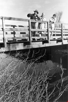
Liz Thurstrom, Bob Gardner, and Ken Elliot
https://search.heritageburnaby.ca/link/archivedescription78731
- Repository
- City of Burnaby Archives
- Date
- December 10, 1995
- Collection/Fonds
- Burnaby NewsLeader photograph collection
- Description Level
- Item
- Physical Description
- 1 photograph : b&w ; 23.5 x 16 cm
- Scope and Content
- Photograph of Liz Thurstrom, of the Wildlife Rescue Association of British Columbia, Bob Gardner, of the Burnaby Lake advisory council and Ken Elliot, of the Greater Vancouver Regional District (GVRD) atop the new footbridge completing the Burnaby Lake Trail.
- Repository
- City of Burnaby Archives
- Date
- December 10, 1995
- Collection/Fonds
- Burnaby NewsLeader photograph collection
- Physical Description
- 1 photograph : b&w ; 23.5 x 16 cm
- Description Level
- Item
- Record No.
- 535-0088
- Access Restriction
- No restrictions
- Reproduction Restriction
- No reproduction permitted
- Accession Number
- 2012-11
- Scope and Content
- Photograph of Liz Thurstrom, of the Wildlife Rescue Association of British Columbia, Bob Gardner, of the Burnaby Lake advisory council and Ken Elliot, of the Greater Vancouver Regional District (GVRD) atop the new footbridge completing the Burnaby Lake Trail.
- Media Type
- Photograph
- Photographer
- Bartel, Mario
- Notes
- Title based on contents of photograph
- Note in black and blue ink on recto of photograph reads: "3454 A Bby Mario / 95% Bby p.1"
- Trim marks and/or reproduction instructions on recto (scan is cropped)
- Geographic Access
- Burnaby Lake
Images

![Local construction, [1999] thumbnail](/media/hpo/_Data/_Archives_Images/_Unrestricted/535/535-3205-1.jpg?width=280)
Local construction
https://search.heritageburnaby.ca/link/archivedescription98126
- Repository
- City of Burnaby Archives
- Date
- [1999]
- Collection/Fonds
- Burnaby NewsLeader photograph collection
- Description Level
- File
- Physical Description
- 2 photographs (tiff) : col.
- Scope and Content
- File contains photographs of two unidentified people observing evidence of construction. One photograph depicts a person looking at a crack in a floor tile while holding a land survey map, and the other depicts an individual looking at a piece of construction equipment on the other side of a chain …
- Repository
- City of Burnaby Archives
- Date
- [1999]
- Collection/Fonds
- Burnaby NewsLeader photograph collection
- Physical Description
- 2 photographs (tiff) : col.
- Description Level
- File
- Record No.
- 535-3205
- Access Restriction
- No restrictions
- Reproduction Restriction
- No restrictions
- Accession Number
- 2018-12
- Scope and Content
- File contains photographs of two unidentified people observing evidence of construction. One photograph depicts a person looking at a crack in a floor tile while holding a land survey map, and the other depicts an individual looking at a piece of construction equipment on the other side of a chain link fence.
- Media Type
- Photograph
- Notes
- Title based on contents of file
- Collected by editorial for use in a June 1999 issue of the Burnaby NewsLeader
Images
![Local construction, [1999] thumbnail](/media/hpo/_Data/_Archives_Images/_Unrestricted/535/535-3205-1.jpg)

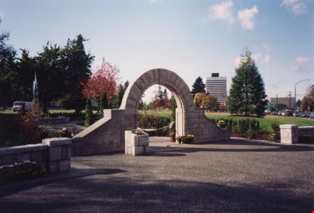
Opening of Lohn Gardens and Restored Jubilee Grove Arch
https://search.heritageburnaby.ca/link/archivedescription37358
- Repository
- City of Burnaby Archives
- Date
- 1994
- Collection/Fonds
- Burnaby Historical Society fonds
- Description Level
- Item
- Physical Description
- 1 photograph : col. ; 10 x 15 cm
- Scope and Content
- Photograph of the Earl and Jennie Lohn Perennial Garden and the restored Jubilee Grove Arch - taken during the opening of the gardens in 1994 after the restoration work was completed. This Central Park landmark was built in 1939 as part of "Jubilee Grove", a garden established in 1935 to commemora…
- Repository
- City of Burnaby Archives
- Date
- 1994
- Collection/Fonds
- Burnaby Historical Society fonds
- Subseries
- Photographs subseries
- Physical Description
- 1 photograph : col. ; 10 x 15 cm
- Description Level
- Item
- Record No.
- 360-001
- Access Restriction
- No restrictions
- Reproduction Restriction
- Reproduce for fair dealing purposes only
- Accession Number
- BHS2007-04
- Scope and Content
- Photograph of the Earl and Jennie Lohn Perennial Garden and the restored Jubilee Grove Arch - taken during the opening of the gardens in 1994 after the restoration work was completed. This Central Park landmark was built in 1939 as part of "Jubilee Grove", a garden established in 1935 to commemorate the Jubilee of King George V and dedicated during Burnaby's May Day Celebration.
- Media Type
- Photograph
- Notes
- Title based on contents of photograph
- Geographic Access
- Kingsway
- Patterson Avenue
- Historic Neighbourhood
- Central Park (Historic Neighbourhood)
- Planning Study Area
- Garden Village Area
Images