More like 'Alfred Bingham's writings - Track 3'
Narrow Results By
Subject
- Aerial Photographs 2
- Animals - Dogs 1
- Animals - Oxen 1
- Buildings - Civic - City Halls 4
- Buildings - Commercial 5
- Buildings - Commercial - Stores 2
- Buildings - Residential - Houses 28
- Buildings - Schools 6
- Construction 44
- Construction - Road Construction 5
- Construction Tools and Equipment 6
- Geographic Features - Lakes and Ponds 1

Birth of a House
https://search.heritageburnaby.ca/link/archivedescription79788
- Repository
- City of Burnaby Archives
- Date
- May 1950
- Collection/Fonds
- Yanko family fonds
- Description Level
- Item
- Physical Description
- 1 photograph : b&w ; 8 x 5.5 cm
- Scope and Content
- Photograph of the construction site for the Yanko family house at 7385 Broadway (later renumbered 7391) in Burnaby.
- Repository
- City of Burnaby Archives
- Date
- May 1950
- Collection/Fonds
- Yanko family fonds
- Physical Description
- 1 photograph : b&w ; 8 x 5.5 cm
- Material Details
- Secured to album page with photo corners
- Description Level
- Item
- Record No.
- 545-438
- Access Restriction
- No restrictions
- Reproduction Restriction
- No restrictions
- Accession Number
- 2012-09
- Scope and Content
- Photograph of the construction site for the Yanko family house at 7385 Broadway (later renumbered 7391) in Burnaby.
- Subjects
- Construction
- Land Clearing
- Media Type
- Photograph
- Notes
- Transcribed title (from album page)
- Note written on album page reads: "'Birth of a House' / Started May 1950 / Moved in April 6, 1951"
- Note in black ink on verso of photograph reads: "#6 House May 1950"
- Street Address
- 7391 Broadway
- Planning Study Area
- Sperling-Broadway Area
Images

![Historic photo of Cariboo Road, [190-] date of original, copied [198_] thumbnail](/media/hpo/_Data/_BVM_Images/2020/2020_0005_0860_001.jpg?width=280)
Historic photo of Cariboo Road
https://search.heritageburnaby.ca/link/museumdescription13516
- Repository
- Burnaby Village Museum
- Date
- [190-] date of original, copied [198_]
- Collection/Fonds
- Century Park Museum Association fonds
- Description Level
- Item
- Physical Description
- 1 photograph : b&w print ; 8.7 x 12.5 cm
- Scope and Content
- Photograph of a historic photograph of an unidentified man standing on a boardwalk on the corner of Cariboo Road in Burnaby. Historic photograph includes a label in the top corner that reads: "Cariboo Rd / Burnaby". The road is made of dirt and a two story house is visible across the road from the …
- Repository
- Burnaby Village Museum
- Collection/Fonds
- Century Park Museum Association fonds
- Description Level
- Item
- Physical Description
- 1 photograph : b&w print ; 8.7 x 12.5 cm
- Scope and Content
- Photograph of a historic photograph of an unidentified man standing on a boardwalk on the corner of Cariboo Road in Burnaby. Historic photograph includes a label in the top corner that reads: "Cariboo Rd / Burnaby". The road is made of dirt and a two story house is visible across the road from the man.
- Subjects
- Construction - Road Construction
- Names
- Burnaby Village Museum
- Geographic Access
- Cariboo Road
- Accession Code
- BV020.5.860
- Access Restriction
- No restrictions
- Reproduction Restriction
- May be restricted by third party rights
- Date
- [190-] date of original, copied [198_]
- Media Type
- Photograph
- Scan Resolution
- 600
- Scan Date
- 25-Aug-2020
- Scale
- 100
- Photographer
- Brown, Cice Chandler
- Notes
- Title based on contents of photograph
Images
![Historic photo of Cariboo Road, [190-] date of original, copied [198_] thumbnail](/media/hpo/_Data/_BVM_Images/2020/2020_0005_0860_001.jpg)

Jubilee Avenue
https://search.heritageburnaby.ca/link/museumdescription1699
- Repository
- Burnaby Village Museum
- Date
- May 1955
- Collection/Fonds
- Burnaby Village Museum Photograph collection
- Description Level
- Item
- Physical Description
- 1 photograph : b&w ; 7.5 x 7.5 cm
- Scope and Content
- Photograph of a section of Jubilee Avenue; the entire span of the paved road has been dug up and two trucks are visible driving over the muddy ground.
- Repository
- Burnaby Village Museum
- Collection/Fonds
- Burnaby Village Museum Photograph collection
- Description Level
- Item
- Physical Description
- 1 photograph : b&w ; 7.5 x 7.5 cm
- Scope and Content
- Photograph of a section of Jubilee Avenue; the entire span of the paved road has been dug up and two trucks are visible driving over the muddy ground.
- Geographic Access
- Jubilee Avenue
- Accession Code
- BV004.7.5
- Access Restriction
- Restricted access
- Reproduction Restriction
- May be restricted by third party rights
- Date
- May 1955
- Media Type
- Photograph
- Historic Neighbourhood
- Alta-Vista (Historic Neighbourhood)
- Planning Study Area
- Sussex-Nelson Area
- Related Material
- For another photograph of roadwork scene at Jubilee Avenue, see BV004.7.6
- Scan Resolution
- 600
- Scan Date
- 09-Jun-09
- Scale
- 100
- Notes
- Title based on contents of photograph
- Note in blue ink on verso of photograph reads: "Jubilee Ave/ May 1955"
Images


Jubilee Avenue
https://search.heritageburnaby.ca/link/museumdescription1700
- Repository
- Burnaby Village Museum
- Date
- May 1955
- Collection/Fonds
- Burnaby Village Museum Photograph collection
- Description Level
- Item
- Physical Description
- 1 photograph : b&w ; 7.5 x 7.5 cm
- Scope and Content
- Photograph of a section of Jubilee Avenue; the entire span of the paved road has been dug up and a line of dump trucks are driving over the muddy ground in the distance.
- Repository
- Burnaby Village Museum
- Collection/Fonds
- Burnaby Village Museum Photograph collection
- Description Level
- Item
- Physical Description
- 1 photograph : b&w ; 7.5 x 7.5 cm
- Scope and Content
- Photograph of a section of Jubilee Avenue; the entire span of the paved road has been dug up and a line of dump trucks are driving over the muddy ground in the distance.
- Geographic Access
- Jubilee Avenue
- Accession Code
- BV004.7.6
- Access Restriction
- Restricted access
- Reproduction Restriction
- May be restricted by third party rights
- Date
- May 1955
- Media Type
- Photograph
- Historic Neighbourhood
- Alta-Vista (Historic Neighbourhood)
- Planning Study Area
- Sussex-Nelson Area
- Related Material
- For another photograph of roadwork scene at Jubilee Avenue, see BV004.7.5
- Scan Resolution
- 600
- Scan Date
- 09-Jun-09
- Notes
- Title based on contents of photograph
- Note in blue ink on verso of photograph reads: "At its worst/ Jubilee Ave/ South Burnaby/ May 1955"
Images

![Overpass, [195-] (date of original), copied 1976 thumbnail](/media/hpo/_Data/_BVM_Images/1974/197602510029.jpg?width=280)
Overpass
https://search.heritageburnaby.ca/link/museumdescription1624
- Repository
- Burnaby Village Museum
- Date
- [195-] (date of original), copied 1976
- Collection/Fonds
- Burnaby Village Museum Photograph collection
- Description Level
- Item
- Physical Description
- 1 photograph : col. negative ; 4.5 x 6.5 cm
- Scope and Content
- Photograph of a newly constructed overpass, with a roadway below prepared for construction. An unidentified man is standing on the right side. The location is unidentified, but it is likely that the photograph was taken in Burnaby.
- Repository
- Burnaby Village Museum
- Collection/Fonds
- Burnaby Village Museum Photograph collection
- Description Level
- Item
- Physical Description
- 1 photograph : col. negative ; 4.5 x 6.5 cm
- Scope and Content
- Photograph of a newly constructed overpass, with a roadway below prepared for construction. An unidentified man is standing on the right side. The location is unidentified, but it is likely that the photograph was taken in Burnaby.
- Accession Code
- HV976.251.29
- Access Restriction
- No restrictions
- Reproduction Restriction
- May be restricted by third party rights
- Date
- [195-] (date of original), copied 1976
- Media Type
- Photograph
- Scan Resolution
- 300
- Scan Date
- 22/8/2006
- Scale
- 100
- Notes
- Title based on contents of photograph
- The print is made as a black and white print from a colour negative film
Images
![Overpass, [195-] (date of original), copied 1976 thumbnail](/media/hpo/_Data/_BVM_Images/1974/197602510029.jpg)
![Street clearing, [195-] (date of original), copied 1976 thumbnail](/media/hpo/_Data/_BVM_Images/1974/197602510027.jpg?width=280)
Street clearing
https://search.heritageburnaby.ca/link/museumdescription1622
- Repository
- Burnaby Village Museum
- Date
- [195-] (date of original), copied 1976
- Collection/Fonds
- Burnaby Village Museum Photograph collection
- Description Level
- Item
- Physical Description
- 1 photograph : col. negative ; 4.5 x 6.5 cm
- Scope and Content
- Photograph of the Grandview ramp off of the Trans Canada Highway in Burnaby that is cleared, possibly in preparation for the highway. The clearing for the street is several lanes wide, and in the distance, an overpass bridge can be seen. There are houses and along both sides of the cleared street.
- Repository
- Burnaby Village Museum
- Collection/Fonds
- Burnaby Village Museum Photograph collection
- Description Level
- Item
- Physical Description
- 1 photograph : col. negative ; 4.5 x 6.5 cm
- Scope and Content
- Photograph of the Grandview ramp off of the Trans Canada Highway in Burnaby that is cleared, possibly in preparation for the highway. The clearing for the street is several lanes wide, and in the distance, an overpass bridge can be seen. There are houses and along both sides of the cleared street.
- Accession Code
- HV976.251.27
- Access Restriction
- No restrictions
- Reproduction Restriction
- May be restricted by third party rights
- Date
- [195-] (date of original), copied 1976
- Media Type
- Photograph
- Scan Resolution
- 300
- Scan Date
- 22/8/2006
- Scale
- 100
- Notes
- Title based on contents of photograph
- The print is made as a black and white print from a colour negative film
Images
![Street clearing, [195-] (date of original), copied 1976 thumbnail](/media/hpo/_Data/_BVM_Images/1974/197602510027.jpg)
![Aerial photograph of Burnaby Mountain, [1957 or 1958] thumbnail](/media/hpo/_Data/_Archives_Images/_Unrestricted/371/476-025.jpg?width=280)
Aerial photograph of Burnaby Mountain
https://search.heritageburnaby.ca/link/archivedescription39742
- Repository
- City of Burnaby Archives
- Date
- [1957 or 1958]
- Collection/Fonds
- Burnaby Historical Society fonds
- Description Level
- Item
- Physical Description
- 1 photograph : b&w ; 14 x 14 cm
- Scope and Content
- Aerial photograph of the Burnaby Mountain park and Centennial Pavilion, under construction.
- Repository
- City of Burnaby Archives
- Date
- [1957 or 1958]
- Collection/Fonds
- Burnaby Historical Society fonds
- Subseries
- North Burnaby Board of Trade subseries
- Physical Description
- 1 photograph : b&w ; 14 x 14 cm
- Description Level
- Item
- Record No.
- 476-025
- Access Restriction
- No restrictions
- Reproduction Restriction
- Reproduce for fair dealing purposes only
- Accession Number
- BHS2005-8
- Scope and Content
- Aerial photograph of the Burnaby Mountain park and Centennial Pavilion, under construction.
- Subjects
- Aerial Photographs
- Land Clearing
- Media Type
- Photograph
- Photographer
- Hunting Survey Corporation Limited
- Notes
- Title based on contents of photograph.
- Geographic Access
- Burnaby Mountain Conservation Area
- Centennial Way
- Street Address
- 100 Centennial Way
- Planning Study Area
- Burnaby Mountain Area
Images
![Aerial photograph of Burnaby Mountain, [1957 or 1958] thumbnail](/media/hpo/_Data/_Archives_Images/_Unrestricted/371/476-025.jpg)
Aerial photograph of Burnaby Mountain
https://search.heritageburnaby.ca/link/archivedescription64460
- Repository
- City of Burnaby Archives
- Date
- [1957 or 1958]
- Collection/Fonds
- Burnaby Historical Society fonds
- Description Level
- Item
- Physical Description
- 1 photograph : b&w ; 14 x 14 cm
- Scope and Content
- Aerial photograph of the Burnaby Mountain park and Centennial Pavilion, under construction.
- Repository
- City of Burnaby Archives
- Date
- [1957 or 1958]
- Collection/Fonds
- Burnaby Historical Society fonds
- Subseries
- North Burnaby Board of Trade subseries
- Physical Description
- 1 photograph : b&w ; 14 x 14 cm
- Description Level
- Item
- Record No.
- 476-026
- Access Restriction
- No restrictions
- Reproduction Restriction
- Reproduce for fair dealing purposes only
- Accession Number
- BHS2005-8
- Scope and Content
- Aerial photograph of the Burnaby Mountain park and Centennial Pavilion, under construction.
- Subjects
- Aerial Photographs
- Land Clearing
- Media Type
- Photograph
- Photographer
- Hunting Survey Corporation Limited
- Notes
- Title based on contents of photograph
- Geographic Access
- Burnaby Mountain Conservation Area
- Centennial Way
- Street Address
- 100 Centennial Way
- Planning Study Area
- Burnaby Mountain Area
![Clearing Deer Lake frontage, [1891] thumbnail](/media/hpo/_Data/_Archives_Images/_Unrestricted/477/477-842.jpg?width=280)
Clearing Deer Lake frontage
https://search.heritageburnaby.ca/link/archivedescription39523
- Repository
- City of Burnaby Archives
- Date
- [1891]
- Collection/Fonds
- Peers Family and Hill Family fonds
- Description Level
- Item
- Physical Description
- 1 photograph : b&w ; 9.5 x 14.3 cm on page 21.5 x 8 cm (pasted in album)
- Scope and Content
- Photograph of a man and his dog sitting on a large felled tree along the shore of Deer Lake. The man is most likely Claude Hill, and early resident of the Deer Lake area.
- Repository
- City of Burnaby Archives
- Date
- [1891]
- Collection/Fonds
- Peers Family and Hill Family fonds
- Physical Description
- 1 photograph : b&w ; 9.5 x 14.3 cm on page 21.5 x 8 cm (pasted in album)
- Description Level
- Item
- Record No.
- 477-842
- Access Restriction
- No restrictions
- Reproduction Restriction
- No known restrictions
- Accession Number
- 2007-12
- Scope and Content
- Photograph of a man and his dog sitting on a large felled tree along the shore of Deer Lake. The man is most likely Claude Hill, and early resident of the Deer Lake area.
- Media Type
- Photograph
- Notes
- Title based on caption accompanying photograph
- Geographic Access
- Deer Lake
- Historic Neighbourhood
- Burnaby Lake (Historic Neighbourhood)
Images
![Clearing Deer Lake frontage, [1891] thumbnail](/media/hpo/_Data/_Archives_Images/_Unrestricted/477/477-842.jpg)
![Clearing for shopping centre, [1958] thumbnail](/media/hpo/_Data/_Archives_Images/_Unrestricted/559/564-002.jpg?width=280)
Clearing for shopping centre
https://search.heritageburnaby.ca/link/archivedescription85130
- Repository
- City of Burnaby Archives
- Date
- [1958]
- Collection/Fonds
- Ben Bradley collection
- Description Level
- Item
- Physical Description
- 1 photograph : b&w ; 8.2 x 11.5 cm
- Scope and Content
- Photograph of land being cleared for the Brentwood Mall with Burnaby mountain in the background.
- Repository
- City of Burnaby Archives
- Date
- [1958]
- Collection/Fonds
- Ben Bradley collection
- Physical Description
- 1 photograph : b&w ; 8.2 x 11.5 cm
- Description Level
- Item
- Record No.
- 564-002
- Access Restriction
- No restrictions
- Reproduction Restriction
- Reproduce for fair dealing purposes only
- Accession Number
- 2013-30
- Scope and Content
- Photograph of land being cleared for the Brentwood Mall with Burnaby mountain in the background.
- Subjects
- Buildings - Commercial
- Land Clearing
- Media Type
- Photograph
- Notes
- Transcribed title
- Note on verso reads: "Clearing for shopping centre"
- Street Address
- 4567 Lougheed Highway
- Planning Study Area
- Brentwood Area
Images
![Clearing for shopping centre, [1958] thumbnail](/media/hpo/_Data/_Archives_Images/_Unrestricted/559/564-002.jpg)
![Clearing for shopping centre, [1958] thumbnail](/media/hpo/_Data/_Archives_Images/_Unrestricted/559/564-003.jpg?width=280)
Clearing for shopping centre
https://search.heritageburnaby.ca/link/archivedescription85131
- Repository
- City of Burnaby Archives
- Date
- [1958]
- Collection/Fonds
- Ben Bradley collection
- Description Level
- Item
- Physical Description
- 1 photograph : b&w ; 8.2 x 11.5 cm
- Scope and Content
- Photograph with tree stumps, rocks and dirt of land being cleared for the Brentwood Mall.
- Repository
- City of Burnaby Archives
- Date
- [1958]
- Collection/Fonds
- Ben Bradley collection
- Physical Description
- 1 photograph : b&w ; 8.2 x 11.5 cm
- Description Level
- Item
- Record No.
- 564-003
- Access Restriction
- No restrictions
- Reproduction Restriction
- Reproduce for fair dealing purposes only
- Accession Number
- 2013-30
- Scope and Content
- Photograph with tree stumps, rocks and dirt of land being cleared for the Brentwood Mall.
- Subjects
- Buildings - Commercial
- Land Clearing
- Media Type
- Photograph
- Notes
- Title based on contents of photograph
- Street Address
- 4567 Lougheed Highway
- Planning Study Area
- Brentwood Area
Images
![Clearing for shopping centre, [1958] thumbnail](/media/hpo/_Data/_Archives_Images/_Unrestricted/559/564-003.jpg)
![Clearing for shopping centre, [1958] thumbnail](/media/hpo/_Data/_Archives_Images/_Unrestricted/559/564-005.jpg?width=280)
Clearing for shopping centre
https://search.heritageburnaby.ca/link/archivedescription85133
- Repository
- City of Burnaby Archives
- Date
- [1958]
- Collection/Fonds
- Ben Bradley collection
- Description Level
- Item
- Physical Description
- 1 photograph : b&w ; 8.2 x 11.5 cm
- Scope and Content
- Photograph with tree stumps, rocks and dirt of land being cleared for the Brentwood Mall.
- Repository
- City of Burnaby Archives
- Date
- [1958]
- Collection/Fonds
- Ben Bradley collection
- Physical Description
- 1 photograph : b&w ; 8.2 x 11.5 cm
- Description Level
- Item
- Record No.
- 564-005
- Access Restriction
- No restrictions
- Reproduction Restriction
- Reproduce for fair dealing purposes only
- Accession Number
- 2013-30
- Scope and Content
- Photograph with tree stumps, rocks and dirt of land being cleared for the Brentwood Mall.
- Subjects
- Buildings - Commercial
- Land Clearing
- Media Type
- Photograph
- Notes
- Transcribed title
- Note on verso reads: "Clearing for shopping centre"
- Street Address
- 4567 Lougheed Highway
- Planning Study Area
- Brentwood Area
Images
![Clearing for shopping centre, [1958] thumbnail](/media/hpo/_Data/_Archives_Images/_Unrestricted/559/564-005.jpg)
![Clearing for the shopping centre, [1958] thumbnail](/media/hpo/_Data/_Archives_Images/_Unrestricted/559/564-001.jpg?width=280)
Clearing for the shopping centre
https://search.heritageburnaby.ca/link/archivedescription85125
- Repository
- City of Burnaby Archives
- Date
- [1958]
- Collection/Fonds
- Ben Bradley collection
- Description Level
- Item
- Physical Description
- 1 photograph : b&w ; 8.2 x 11.5 cm
- Scope and Content
- Photograph of children climbing on a large tree stump on land being cleared for the Brentwood Mall.
- Repository
- City of Burnaby Archives
- Date
- [1958]
- Collection/Fonds
- Ben Bradley collection
- Physical Description
- 1 photograph : b&w ; 8.2 x 11.5 cm
- Description Level
- Item
- Record No.
- 564-001
- Access Restriction
- No restrictions
- Reproduction Restriction
- Reproduce for fair dealing purposes only
- Accession Number
- 2013-30
- Scope and Content
- Photograph of children climbing on a large tree stump on land being cleared for the Brentwood Mall.
- Subjects
- Buildings - Commercial
- Land Clearing
- Media Type
- Photograph
- Notes
- Transcribed title
- Note on verso reads: "Clearing for shopping centre"
- Street Address
- 4567 Lougheed Highway
- Planning Study Area
- Brentwood Area
Images
![Clearing for the shopping centre, [1958] thumbnail](/media/hpo/_Data/_Archives_Images/_Unrestricted/559/564-001.jpg)

Clearing land with a team of oxen
https://search.heritageburnaby.ca/link/archivedescription39524
- Repository
- City of Burnaby Archives
- Date
- 1890
- Collection/Fonds
- Peers Family and Hill Family fonds
- Description Level
- Item
- Physical Description
- 1 photograph : sepia ; 15.6 x 23.8 cm on page 21.5 x 28 cm (pasted in album)
- Scope and Content
- Photograph of a team of oxen being used to clear land and haul logs on skid road. Five unidentified lumberjacks can be seen standing alongside the animals.
- Repository
- City of Burnaby Archives
- Date
- 1890
- Collection/Fonds
- Peers Family and Hill Family fonds
- Physical Description
- 1 photograph : sepia ; 15.6 x 23.8 cm on page 21.5 x 28 cm (pasted in album)
- Description Level
- Item
- Record No.
- 477-843
- Access Restriction
- No restrictions
- Reproduction Restriction
- No known restrictions
- Accession Number
- 2007-12
- Scope and Content
- Photograph of a team of oxen being used to clear land and haul logs on skid road. Five unidentified lumberjacks can be seen standing alongside the animals.
- Subjects
- Woodworking Tools and Equipment - Logging Machinery
- Industries - Forestry
- Animals - Oxen
- Occupations - Lumberjacks
- Land Clearing
- Industries - Logging/lumber
- Media Type
- Photograph
- Notes
- Title based on contents of photograph
Images

![Douglas Road, [1897] (date of original), copied 1978 thumbnail](/media/hpo/_Data/_BVM_Images/1978/1978_0001_0001_001.jpg?width=280)
Douglas Road
https://search.heritageburnaby.ca/link/museumdescription447
- Repository
- Burnaby Village Museum
- Date
- [1897] (date of original), copied 1978
- Collection/Fonds
- Burnaby Village Museum Photograph collection
- Description Level
- Item
- Physical Description
- 1 photograph : b&w ; 20.2 x 25.2 cm print
- Scope and Content
- Photograph of Douglas Road (later renamed in part Canada Way), near Stanley Street. To the right is the Sprott family property, where a few wooden buildings are visible in the cleared area. Charles Sprott, head of the Sprott family, was an important Burnaby politician who was continuously elected t…
- Repository
- Burnaby Village Museum
- Collection/Fonds
- Burnaby Village Museum Photograph collection
- Description Level
- Item
- Physical Description
- 1 photograph : b&w ; 20.2 x 25.2 cm print
- Scope and Content
- Photograph of Douglas Road (later renamed in part Canada Way), near Stanley Street. To the right is the Sprott family property, where a few wooden buildings are visible in the cleared area. Charles Sprott, head of the Sprott family, was an important Burnaby politician who was continuously elected to serve in the municiality as councillor from 1895 to 1903 and as Reeve from 1904 to 1905.
- Subjects
- Geographic Features - Roads
- Land Clearing
- Geographic Access
- Douglas Road
- Canada Way
- Stanley Street
- Accession Code
- HV978.1.1
- Access Restriction
- No restrictions
- Reproduction Restriction
- No known restrictions
- Date
- [1897] (date of original), copied 1978
- Media Type
- Photograph
- Historic Neighbourhood
- Burnaby Lake (Historic Neighbourhood)
- Planning Study Area
- Lakeview-Mayfield Area
- Scan Resolution
- 600
- Scan Date
- 2023-07-25
- Notes
- Title based on contents of photograph
Images
![Douglas Road, [1897] (date of original), copied 1978 thumbnail](/media/hpo/_Data/_BVM_Images/1978/1978_0001_0001_001.jpg)

People next to a large fallen tree
https://search.heritageburnaby.ca/link/archivedescription39514
- Repository
- City of Burnaby Archives
- Date
- 1898
- Collection/Fonds
- Peers Family and Hill Family fonds
- Description Level
- Item
- Physical Description
- 1 photograph : sepia ; 9.8 x 13.5 cm on page 21.5 x 28 cm (pasted in album)
- Scope and Content
- Photograph of a group of people next to a very large fallen tree. The photograph was taken just above Deer Lake Avenue and the home of Bernard Hill can be seen in the background. Identified in the picture are Mrs. Sprott (standing in front of tree to the left), directly in front of her, lying on th…
- Repository
- City of Burnaby Archives
- Date
- 1898
- Collection/Fonds
- Peers Family and Hill Family fonds
- Physical Description
- 1 photograph : sepia ; 9.8 x 13.5 cm on page 21.5 x 28 cm (pasted in album)
- Description Level
- Item
- Record No.
- 477-833
- Access Restriction
- No restrictions
- Reproduction Restriction
- No known restrictions
- Accession Number
- 2007-12
- Scope and Content
- Photograph of a group of people next to a very large fallen tree. The photograph was taken just above Deer Lake Avenue and the home of Bernard Hill can be seen in the background. Identified in the picture are Mrs. Sprott (standing in front of tree to the left), directly in front of her, lying on the ground is Bernard Hill. The woman standing farthest to the right (next to man holding child) is Marian Hill and next to her is Claude Hill holding his daughter Kitty. The man farthest to the right is Mr. Sprott. The rest are unidentified.
- Subjects
- Land Clearing
- Plants - Trees
- Names
- Hill, Bernard R.
- Hill, Marian Berkeley
- Hill, Louis Claude "Claude"
- Peers, Katherine Maude Hill "Kitty"
- Media Type
- Photograph
- Notes
- Title based on caption accompanying photograph
- Geographic Access
- Deer Lake Avenue
- Historic Neighbourhood
- Burnaby Lake (Historic Neighbourhood)
- Planning Study Area
- Douglas-Gilpin Area
Images

![Start of Brentwood Shopping Centre 1958, [1958] thumbnail](/media/hpo/_Data/_Archives_Images/_Unrestricted/559/564-004.jpg?width=280)
Start of Brentwood Shopping Centre 1958
https://search.heritageburnaby.ca/link/archivedescription85132
- Repository
- City of Burnaby Archives
- Date
- [1958]
- Collection/Fonds
- Ben Bradley collection
- Description Level
- Item
- Physical Description
- 1 photograph : b&w ; 8.2 x 11.5 cm
- Scope and Content
- Photograph with tree stumps, rocks and dirt of land being cleared for the Brentwood Mall.
- Repository
- City of Burnaby Archives
- Date
- [1958]
- Collection/Fonds
- Ben Bradley collection
- Physical Description
- 1 photograph : b&w ; 8.2 x 11.5 cm
- Description Level
- Item
- Record No.
- 564-004
- Access Restriction
- No restrictions
- Reproduction Restriction
- Reproduce for fair dealing purposes only
- Accession Number
- 2013-30
- Scope and Content
- Photograph with tree stumps, rocks and dirt of land being cleared for the Brentwood Mall.
- Subjects
- Buildings - Commercial
- Land Clearing
- Media Type
- Photograph
- Notes
- Transcribed title
- Note on verso reads: "Start of Brentwood Shopping Centre 1958"
- Street Address
- 4567 Lougheed Highway
- Planning Study Area
- Brentwood Area
Images
![Start of Brentwood Shopping Centre 1958, [1958] thumbnail](/media/hpo/_Data/_Archives_Images/_Unrestricted/559/564-004.jpg)
![Brick Houses under Construction, [between 1899 and 1910] thumbnail](/media/hpo/_Data/_Archives_Images/_Unrestricted/513/514-003.jpg?width=280)
Brick Houses under Construction
https://search.heritageburnaby.ca/link/archivedescription64654
- Repository
- City of Burnaby Archives
- Date
- [between 1899 and 1910]
- Collection/Fonds
- Ernest Winch fonds
- Description Level
- Item
- Physical Description
- 1 photograph : b&w cabinet card ; 10 x 14.5 cm, mounted on card 10.5 x 16.5 cm
- Scope and Content
- Photograph of two brick houses under construction on High Street at Epping, Essex, England. These buildings were constructed by Ernest E. Winch.
- Repository
- City of Burnaby Archives
- Date
- [between 1899 and 1910]
- Collection/Fonds
- Ernest Winch fonds
- Physical Description
- 1 photograph : b&w cabinet card ; 10 x 14.5 cm, mounted on card 10.5 x 16.5 cm
- Description Level
- Item
- Record No.
- 514-003
- Access Restriction
- No restrictions
- Reproduction Restriction
- No known restrictions
- Accession Number
- 2010-06
- Scope and Content
- Photograph of two brick houses under construction on High Street at Epping, Essex, England. These buildings were constructed by Ernest E. Winch.
- Subjects
- Construction
- Buildings - Residential - Houses
- Construction Tools and Equipment
- Occupations - Labourers
- Media Type
- Photograph
- Photographer
- Challoner-Courtenay, E.J.
- Notes
- Title based on contents of photograph
Images
![Brick Houses under Construction, [between 1899 and 1910] thumbnail](/media/hpo/_Data/_Archives_Images/_Unrestricted/513/514-003.jpg)
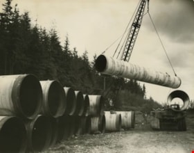
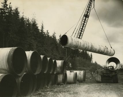
Dominion Bridge Co. Ltd.
https://search.heritageburnaby.ca/link/archivedescription34680
- Repository
- City of Burnaby Archives
- Date
- 1957
- Collection/Fonds
- Burnaby Historical Society fonds
- Description Level
- Item
- Physical Description
- 1 photograph : b&w ; 20.5 x 25.0 cm mounted on cardboard
- Scope and Content
- Photograph of a crane lifting a large pipe on or off a truck at the Dominion Bridge Co. Ltd. A number of other pipes are piled at the left side of the photograph.
- Repository
- City of Burnaby Archives
- Date
- 1957
- Collection/Fonds
- Burnaby Historical Society fonds
- Subseries
- Photographs subseries
- Physical Description
- 1 photograph : b&w ; 20.5 x 25.0 cm mounted on cardboard
- Description Level
- Item
- Record No.
- 092-001
- Access Restriction
- No restrictions
- Reproduction Restriction
- Reproduce for fair dealing purposes only
- Accession Number
- BHS2007-04
- Scope and Content
- Photograph of a crane lifting a large pipe on or off a truck at the Dominion Bridge Co. Ltd. A number of other pipes are piled at the left side of the photograph.
- Names
- Dominion Bridge Company
- Media Type
- Photograph
- Photographer
- Graphic Industries Limited
- Notes
- Title based on contents of photograph
- Printed on bottom of photo, "Dominion Bridge Co., Limited / Pacific Division"
- Printed on back of cardboard "GIL: Graphic Industries Ltd. / Vancouver's Most Complete Photographic Service / 54 West Hastings, Vancouver 4, B.C. / Phone Pacific 4174 File No: 3850-4"
- Geographic Access
- Henning Drive
- Street Address
- 3880 Henning Drive
- Historic Neighbourhood
- Broadview (Historic Neighbourhood)
- Planning Study Area
- West Central Valley Area
Images
Dominion Bridge Co. Ltd.
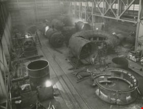
https://search.heritageburnaby.ca/link/archivedescription34681
- Repository
- City of Burnaby Archives
- Date
- January 1956
- Collection/Fonds
- Burnaby Historical Society fonds
- Description Level
- Item
- Physical Description
- 1 photograph : b&w ; 20.5 x 25.3 cm
- Scope and Content
- Photograph of the fabrication of large construction industry components inside a Dominion Bridge Co. Ltd. building.
- Repository
- City of Burnaby Archives
- Date
- January 1956
- Collection/Fonds
- Burnaby Historical Society fonds
- Subseries
- Photographs subseries
- Physical Description
- 1 photograph : b&w ; 20.5 x 25.3 cm
- Description Level
- Item
- Record No.
- 092-002
- Access Restriction
- No restrictions
- Reproduction Restriction
- Reproduce for fair dealing purposes only
- Accession Number
- BHS2007-04
- Scope and Content
- Photograph of the fabrication of large construction industry components inside a Dominion Bridge Co. Ltd. building.
- Names
- Dominion Bridge Company
- Media Type
- Photograph
- Photographer
- Graphic Industries Limited
- Notes
- Title based on contents of photograph
- Printed on bottom of photo, "Dominion Bridge Co., Limited / Pacific Division"
- Printed on back of cardboard "GIL: Graphic Industries Ltd. / 54 West Hastings, Vancouver 4, B.C. / Phone Pacific 4174 File No: 2844 1"
- Stamped and annotated on back of cardboard, "Dominion Bridge Co. Ltd. / Vancouver, B.C. / Neg./Print #55-DB-3-32" and "Jan. /56"
- Geographic Access
- Henning Drive
- Street Address
- 3880 Henning Drive
- Historic Neighbourhood
- Broadview (Historic Neighbourhood)
- Planning Study Area
- West Central Valley Area
Images
